竹島問題の歴史

29.1.08

Dong-A Ilbo: "Japanese Netizens Actively Promote 'Takeshima'"

The following is my translation of a January 28 article in the Korean newspaper, "Dong-a Ilbo":
"Japanese Netizens Actively Promote 'Takeshima'"

Japanese netizens are actively promoting "Takeshima" (called "Dokdo" in Korea).

According to the Voluntary Agency Network of Korea (VANK), on the 28th, Japanese netizens will use a site entitled "2008 Takeshima project" (sakurasakurasakura3.blog53.fc2.com/blog-entry-342.html) to achieve solidarity and systematically promote Dokdo as "Takeshima."

The site will insist to bloggers and site managers that Dokdo is "Takeshima," and will post such things as articles, pictures, and video. It will also ask that people participate in a survey on an English site that asks about the sovereignty of Dokdo. It is also proposing that people again link to Shimane (島根) Prefecture's multi-lingual information page on Takeshima (dokdo-or-takeshima.blogspot.com).

The site presently has more than 100 bloggers and site managers participating.

The President of VANK, Bak Gi-tae, said, "Moreover, the problem is serious because this site induces anti-Korean content by linking bloggers to sites where they can purchase, "Hating the Korean Wave," which is a book written by Japanese right-wingers."

President Bak said, "If you type '2008 Takeshima' (2008年竹島) into the overseas search engine 'Google' (
www.google.com), you can easily confirm that the Japanese sites participating in this movement are rapidly spreading." He added, "To deal with this, VANK will begin a serious infomation campaign by networking with friendly bloggers, domestically and overseas, and setting up a blogger hub site to promote to the world Dokdo, Goguryo, and pro-Korean-wave information.
Notice that the newspaper gave our site's address as the multi-lingual web site for Shimane Prefecture's Takeshima's information page. Not only is that information wrong, but the Korean sentences in the article seem to be poorly written.

Link to the Korean article

Link to the Japanese blog referred to in the article

18.1.08

Yomiuri Shimbun: "Detailed map of Takeshima completed"

The following is a link to a Yomiuri Shimbun article talking about a new topographical map of Takeshima compiled by Japan's Geographical Survey Institute. This news was talked about before, but this English article explains it in an easy-to-understand way and gives some good background information.

"Detailed map of Takehima completed"

17.1.08

2007 - "Takeshima in Japanese map (1)" by Funasugi Rikinobu _1

In this article, the Japanese maps are examined based on "The right of owning Dokdo for South Korea that Japanese old map proves" of the Korean professor Yuji Hosaka. Mr. Hosaka has enumerated three Japanese maps 「嘉永新増 大日本国郡輿地全図 (1849), 「校正大日本輿地全図」(latter term of Edo period), 「改正日本輿地路程全図」(1779).

1) 「嘉永新増 大日本国郡輿地全図」 (1849)

Takashiba Eisanyu (高柴英三雄) is a person in Edo Iigura(江戸飯倉) town 4, and this map is a Japanese map published by 蔦屋吉蔵 who lived in Edo South Denma town 1 in 1849. He is assumed to be a map editor since he had edited and revised various picture maps like Edo map 「嘉永改正府郷御江戸絵図」(1849), 「芝愛宕下西ノ久保辺絵図」(1849), 「駿河台小川町図」(1849), 「日本橋北神田辺之絵図」(1850), or other maps like 「改正銅鐫安房国全図」(1879: revision), 「下野国輿地全図」,「尾張国輿地全図」 etc,.

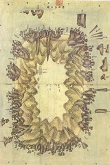
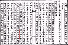
A digital version of this drawing is open to the public on the homepage of the Tohoku University library's Kano pocket edition. The point by Mr. Hosaka, "Dokdo has come off the map though there is an Oki island when studying the map" is incorrect. Matsushima (present Takeshima) and Takeshima (present Ulleundo) are drawn on the west side of Oki islands (Figure 1). However, Takeshima is the south, Matsushima is the north, and the position is inaccurate. However, it is colored in Takeshima and Matsushima, and it is understood that Takashiba recognized both islands within Japanese territory since there is no description of Choson on those islands.

Another point by Mr. Hosaka "And, when the map, on which the entire Japan was drawn, was made at that time, such all those maps should be governmental manufactured or official licensed since the permission of Shogunate Government of Edo was necessary" is important. As a rule, the publication had received the inspection by the Shogunate though it was not able to be said that there was no pirate edition at all. In 1712 (享保6年), the Shogunate placed the order to have publishers report their publishing to the "Bugyosho" (奉行所 : magistrate place). The person who tried to publish the book first had to hand in the drafts and application to "Nengyoji"(年行事 : bakufu supervisors), then if the draft was decided to be good enough to be published, then he had to apply to the "Machidoshiyori"(町年寄 : Town Officials) next, and the applications were passed from 町年寄 to 奉行所, finally to "Gakumonsho"(学問所 : School District). If the 学問所 admitted there were no problems, one were allowed to be licenced to publish (Emori, 1955). .

Actually, the discontinuation was ordered to Hayashi Shihei (林子平)'s map 『三国通覧図説』 in 1792 (寛政4年), six years after it was published in 1786 (天明6年). In the decision sentence by the shogunate for the prohibition of the publish or sale of Hayashi's 『三国通覧図説』, the reason was clearly written that 「地理相違之絵図相添書写又は板行に致し(He had drawn the geographically inaccurate picture maps on the paper attached or the carved on the board)」. Not only Hayashi, but also publisher Suharaya Ichibee(須原屋市兵衛) and even four officers who examined his map became objects for the punishment.

In addition "Tenpo Reform"(天保の改革) strengthened restriction for the publications, and all the drafts of the books were examined at the town magistrate and it was passed to the study place "Gakumonsho"(学問所 : School District), then "Tenmonkata"(天文方 : Astronomical Institute ) and "Igakukan" (医学館 : a Medical School managed directly by the Tokugawa Government) too. It also required to submit the books after it was allowed and published. In other words, the restriction for the prior inspection system and dedication system for the published books as a key point was delivered (Fujita and Sato, 1987). According to 「市中取締類集( the compilation for the town management cases)」 in 1853 (嘉永6年), when Suzuki Hikojirou (鈴木彦次郎 or 驥園), the retainer of Toda Tadanobu (戸田忠偲) , the "Hatamoto"(旗本 : direct retainers of the Shogun) ,applied the publication of the map 「大日本国郡輿地路程全図」, Astronomical Institute permitted on condition that the latitude and longitude line be deleted. In fact, this map has omitted the latitude and longitude line, though the graticule of latitude and longitude are omitted though the longitude is written.

1849 「嘉永新増 大日本国郡輿地全図」
(property of Tohoku University)

日本側作製地図にみる竹島(1)(Takeshima in the Japanese map (1)」 by associate professor Funasugi Rikinobu (舩杉力修) of Shimane University.
Translated by Kaneganese.
Courtesy of Web Takeshima Research Center.

* The abstract of the sentence to Hayashi Shihei and his book which prohibiting the publication of his inaccurate map is as follows ;
"其方儀縦令利欲に不致共一己之名聞に拘り取留も無之風聞又は推察を以て異国より日本を襲う事可有之趣奇怪 異説等取交せ著述致し、且つ右之内には御要害等之儀も認入、其外地理相違之絵図相添書写又は板行に致し室 町二丁目権八店市兵衛へ差使し候始末不憚公儀仕方不届之至に付(中略)蟄居申付並板行物板木共に召上可申 (『六無斎遺草』一八一頁所載)(-248) "

16.1.08

2007 - "Takeshima in the Korean official map" by Funasugi Rikinobu (舩杉力修) - Supplement

Supplement

Well, there were the following counter opinion about the analysis of the map recently. "Originally, maps has huge visual effect, thus it tend to be argued based on only few maps in the territorial debate, but as a matter of fact, inaccurate old maps only have hearsay evidence at most in the international adjudication arena. Especially the map which is not based on the measurement has little evidential ability in fact.(Newsletter No.127 by half moon)."

This person referred the article of Mr. Araki Norio (荒木教夫), who specialises in international law, and concluded that inaccurate old maps are worthless for the international adjudication. However, if you actually read Araki's thesis, it is understood that it is mere a part of quotation.

Araki wrote that the map, which its' value has been admitted in the international adjudication, had been basically the ones which show "Mutual agreement of the country concerned", even they were attached to the border agreement. He also admit that though the official maps of the party in dispute doesn't become the conclusive proof of the dispute solution, but the maps in which the land in concern was diadvantageously drawn and voluntarily admitted it has no sovereignty over the land of concern hold important meanings in dispute. "

However, Korea has absolutely no official maps which described this debatable island favourable to their territorial claim nor sovereignty in the debatable ground. Moreover, there is even no Korean maps which actually described the island in concern (Takeshima/Dokdo) itself at all in the first place. In a word, it can be said that it was clarified that in South Korea, there is no single map that could be used as an evidence in the international adjudication to support their claim.

朝鮮側作製の官製地図にみる竹島(Takeshima in the Korean official map)」 by associate professor Funasugi Rikinobu (舩杉力修) of Shimane University.
Translated by Kaneganese.
Courtesy of
Web Takeshima Research Center.

2007 - "Takeshima in the Korean official map" by Funasugi Rikinobu (舩杉力修) - (5) 『大韓全図』(1899) , 『大韓輿地図』(1900 c.a.)

5)『大韓全図』、『大韓輿地図』

Both "大韓全図" and "大韓輿地図" were published by the faculty of the editing bureau, the Ministry of Education of the Great Korean Empire. The faculty was set up within the government office to rule the school affairs administration in 1895. There were secretariat, a school affairs bureau, and an edit bureau in the faculty, and it had jurisdiction over climate observatory, 成均館(University), the teacher-training school and the junior high school etc. Therefore, it can be said that this map is a government manufactured official map again.

"大韓全図" is a publication in 1899, and the one that latitude and longitude was written for the first time in a Korean complete map. In this map, Ulleundo is recorded, as well as a current Korean map, at the west side and Usando was placed next to the Ulleundo on the east side. In "大韓地誌"published in the same year, the east limit of Korea is declared to be Ulleundo(130° east). The map and the document confirm that the east limit of Korea in 1899 was Ulleundo since present Takeshima/Dokdo locates at 131°52".

"大韓輿地図" is assumed to be publication in about 1900. Ulleundo is recorded at the west side and Usando was placed next to the Ulleundo on the east side just like the description of "大韓全図". South Korea claims that they had promoted the Ulleundo to the county, making "石島", which South Korea insists to be present Takeshima/Dokdo, within their territory at the same time by the Imperial Ordinance No.41 in October, 1900. However, neither "石島" nor the description of Dokdo are seen on the map, though the phantom island in the south of Ulleundo is recorded and Usando as neighbouring island of Ulleundo at the east side. It is thought that having recorded the island in the south of Ulleundo referred to the maps such as "朝鮮地図".

1899 大韓全図 1900 頃 大韓輿地図 old_korea33

As we had seen so far, Korean official maps doesn't have recorded present Takeshima/Dokdo even immediately before Japan incorporates present Takeshima/Dokdo into Shimane, Japan (1905). Prof, Hosaka claims that Japanese official maps in Edo and Meiji era don't include Takeshima/Dokdo, but none of Korean official maps actually didn't drawn Takeshima/Dokdo at all.

*Related articles
1899 Korean Map: "Daehanjeondo" (大韓全圖) (玄采 大韓地誌)
1900 - Imperial Edict Makes Ulleungdo a County of Gangwon Province (大韓勅令第41号)
Lies, Half-truths, and Dokdo Video, Part 8 : "An Yong-bok, Usando, & Matsushima (Songdo)" 肅宗実録(1696), 鬱陵島圖形(1711), 鬱陵島事蹟(1694), 海東地圖(1750s), 輿地圖(1736-67), 朝鮮地圖(1750-1768), 地乘(1776-1800), 東國文獻備考(1770), 日省録(1793), 萬機要覽(1808), 靑邱圖(1835), 朝鮮国交際始末内探書(1869), 高宗実録(1882), 鬱陵島外圖(1882), 大韓全図(1899), 皇城新聞(1899), 大韓勅令勅令第41号(1900)
Lies, Half-truths, and Dokdo Video, Part 11 : 大韓全図(1899), 大韓新地誌(1907), 崔南善「朝鮮常識問答」(1946) 「朝鮮常識」(1948)

朝鮮側作製の官製地図にみる竹島(Takeshima in the Korean official map)」 by associate professor Funasugi Rikinobu (舩杉力修) of Shimane University.
Translated by Kaneganese.
Courtesy of
Web Takeshima Research Center.

2007 -"Takeshima in the Korean official map" by Funasugi Rikinobu (舩杉力修) - (4) 『鬱陵島外図』(1882)

4) 『鬱陵島外図』

It is a map made by 李奎遠, who was dispatched as a prosecutor to Ulleundo by Choson dynasty in 1882. It is which it uses and is sent in 1882. It is currently owned by Kyujangkak of Korean study center, Seoul National University. It can be said that this drawing is a government manufacture map, either.

The document 『鬱陵島検察使日記 (Diary of the inspector to Ulleundo)』 which was made along with this map says that "The islands like Matsu/Take/Usando etc. are all meant to be the small island (of Ulleundo) by the locals. But the neighbouring islands of Ulleundo in this map are only "島頂" and "竹島", and if you compare this map to the present map of Ulleundo, "島頂" is a Kwannundo(観音島) and "竹島" is Jukdo(竹嶼, Korean name 竹島). In a word, it is apparent that inspector 李奎遠 did not investigated present Takeshima/Dokdo at all.

The longtime empty island policy of Ulleundo was ceased by Choson dynasty, and the development of Ulleundo was started in 1882. Thus, it can be said that present Takeshima/Dokdo was not recognized geographically nor furthermore considered to be within their territory by Choson dynasty even when it arrived at time the development of Ulleundo was started in late 19th century.

*Related articles
1882 April 7 - King Kojong says Usando Neighboring Island of Ulleungdo (高宗 19卷, 19年 4月 7日 壬戌)
Lies, Half-truths, and Dokdo Video, Part 3 : 1786 Ulleungdo Inspection : 日省録(1786), 海東地圖(1750 c.a.), 鬱陵島外圖(1882)
Lies, Half-truths, and Dokdo Video, Part 5 : "The King, Lee Gyu-won & Many Names for a Neighboring Island" 高宗19年(1882), 靑邱圖(1834), 英海軍地図(1863), 大日本国沿海略図(1867), 「松島開拓之議」(1877/8), 軍艦「天城」作成地図(1880)
Lies, Half-truths, and Dokdo Video, Part 6 : 海東地圖(1750's), 靑邱圖(1834), 韓国古地図(1800's), 鬱陵島外圖(1882), 日本古地図(1886), 鬱陵島見取図(1905), 韓国水産誌「鬱陵島全図」(1909)
Lies, Half-truths, and Dokdo Video, Part 8 : "An Yong-bok, Usando, & Matsushima (Songdo)" 肅宗実録(1696), 鬱陵島圖形(1711), 鬱陵島事蹟(1694), 海東地圖(1750s), 輿地圖(1736-67), 朝鮮地圖(1750-1768), 地乘(1776-1800), 東國文獻備考(1770), 日省録(1793), 萬機要覽(1808), 靑邱圖(1835), 朝鮮国交際始末内探書(1869), 高宗実録(1882), 鬱陵島外圖(1882), 大韓全図(1899), 皇城新聞(1899), 大韓勅令勅令第41号(1900)
Lies, Half-truths, and Dokdo Video, Maps 2 : "1882 Ulleungdo, an outside view & Seal Cave" 鬱陵島外圖(1882)

朝鮮側作製の官製地図にみる竹島(Takeshima in the Korean official map)」 by associate professor Funasugi Rikinobu (舩杉力修) of Shimane University.
Translated by Kaneganese.
Courtesy of
Web Takeshima Research Center.

2007 -"Takeshima in the Korean official map" by Funasugi Rikinobu (舩杉力修) - (3) 「欝陵島図 in'『朝鮮地図』(1770)

3) 「欝陵島図 in 『朝鮮地図』

"朝鮮地図"is a map which describes 8 prefecture of Choson era and assumed to have been made by the order of the 21th King of Choson, 英祖 in 1770. It is currently owned by Kyujangkak of Korean study center of Seoul National University. It were drawn on ruled paper with relative scale or the graticule, and each county is drawn, and it is assumed that the distance of the location information and accuracy in the direction are expected when it was made. It is said that relative scale is lined in every 20里, and there was 備辺司 sign. Therefore, it can be said that this map is a government manufactured official map, either. The feature of this map is it is a little longer from east to west than the shape of Ulleundo which was described circle up to this, and it drawn the ridge line in the mountainous district. It has been understood that this map draw almost accurately like the port, the river, and the village, etc. as a result of the field investigation, though the island that doesn't exist in the south of the island is drawn.

This map also describes the island labelled as "Usan" about 30里 of Ulleundo on the east side, Both Mr. Bevers and Kyujangkak of Korean study center of Seoul National University admit that this island "Usan"is not a present Takeshima/Liancourt Rocks/Dokdo but the Jukdo which locates in the 2km east of Ulleundo. In a word, present Takeshima/Dokdo is not drawn in figure on this official map of 8 prefecture of Choson made by a Choson dynasty, and it is understood that "Usando" which South Korea insists to be today's Takeshima/Dokdo is actually another island.

*Related articles
1750~1768 - Joseon Jido (朝鮮地圖) - Ulleungdo
Lies, Half-truths, and Dokdo Video, Part 8 : "An Yong-bok, Usando, & Matsushima (Songdo)" 肅宗実録(1696), 鬱陵島圖形(1711), 鬱陵島事蹟(1694), 海東地圖(1750s), 輿地圖(1736-67), 朝鮮地圖(1750-1768), 地乘(1776-1800), 東國文獻備考(1770), 日省録(1793), 萬機要覽(1808), 靑邱圖(1835), 朝鮮国交際始末内探書(1869), 高宗実録(1882), 鬱陵島外圖(1882), 大韓全図(1899), 皇城新聞(1899), 大韓勅令勅令第41号(1900)
Lies, Half-truths, and Dokdo Video, Maps 5 : "Muleungdo (Ullengdo) “also called ‘Usan’” 東輿備攷(1682ca.)輿地圖 (ca. 1730), 地海東地圖(Early 1750s), 朝鮮地圖(1750 - 1768), 地乘(After 1776), 廣輿圖(early 19th century), 靑邱圖(1834)

朝鮮側作製の官製地図にみる竹島(Takeshima in the Korean official map)」 by associate professor Funasugi Rikinobu (舩杉力修) of Shimane University.
Translated by Kaneganese.
Courtesy of
Web Takeshima Research Center.

2007 - "Takeshima in the Korean official map" by Funasugi Rikinobu (舩杉力修) - (2)「欝陵島図形」(1711)

2) 「欝陵島図形」 - "Takeshima in the Korean official map" by Funasugi Rikinobu (舩杉力修)

This map describes the entire Ulleundo and is currently owned by Kyujangkak of Korean study center, Seoul National University. It was made by 朴錫昌, who was the official inspector to Ulleundo in 1711. The stone monument that 朴錫昌 built in 1711 still remains, and has been exhibited in the hometown material pavilion of Ulleundo. It is said that there was a sign of "備辺司" on this map. "備辺司" was the organization that had jurisdiction over the border security at a Choson dynasty, and later, its function was expanded, and strengthened back, and it conferred all the domestic general administration like politics, economy, diplomacy, and the culture, etc. to say nothing of military affairs to be decided. Thus, since this map was made by Choson official commander who were dispatched to clear the illegal squatters from the island, based on his actual survey on Ulleundo, with a official sign of "備辺司" which was the decision making organization at a Choson dynasty, it is safe to say that this map is a official map for Choson dynasty.

Although it is not a modern ordnance map, it has been understood that it is a map where the port, the river, and the village, etc. were drawn almost accurately when you compare the result of the actual field investigation. The most noticeable fact on this map is that there is an island next to Ulleundo on the east side. According to the analysis of Mr. Gerry Bevers, an American resident in Korea, there was a description with "So-called Usando and the field of 海長 bamboo"on this small island. He assumed that "海長 bamboo" was Japanese "女竹", and concluded that this small island (Usando) was Jukdo which locate to the 2km east to Ulleundo, not present Takeshima/Dokdo on which it is impossible to grow the bamboo in any rate. Present Takeshima is located in the southeast from about 90km of Ulleundo.

Therefore, in a so-called official government manufactured map of the Choson dynasty, it is clear that "Usando" is not the present Takeshima/Dokdo on which South Korea insists to be it is.

By the way, there was an counterargument that since there are about hundreds of maps on which Usando was drawn and it is too exaggerated to conclude that it is not Dokdo from only several maps among all. (Takeshima / Dokdo Net News No.6). I wrote an objection to this opinion in the closeout report, saying that "If you insist that there are about hundreds of maps on which Usando was drawn, you have certain obligation to present which maps draw Usando as the today's Takeshima/Dokdo." However, no clear rebuttal is presented by South Korean side yet.

*Related articles ;
1711 - Bak Chang-seok's (朴昌錫) Map of Ulleungdo (「鬱陵島圖形」)
1711 - Ulleungdo Inspector Bak Chang-seok's (朴昌錫) 1711 Inscription
Lies, Half-truths, and Dokdo Video, Maps 7 : 鬱陵島圖形(ca. 1711)

朝鮮側作製の官製地図にみる竹島(Takeshima in the Korean official map)」 by associate professor Funasugi Rikinobu (舩杉力修) of Shimane University.
Translated by Kaneganese.
Courtesy of
Web Takeshima Research Center.

2007 - "Takeshima in the Korean official map" by Funasugi Rikinobu (舩杉力修) - (1) 「八道総図」 in 『新増東国輿地勝覧』(1530)

Sadly, Japanese Government expends only about 10 million yen (90,000-100,000 U.S. dollar) a year though the South Korea government put a huge budget to the Takeshima/Dokdo issue every year. Although Japanese government should be the one who are responsible for the territorial issue essentially, in reality, Shimane Prefecture, which is only one local government with very few budgets is forced to tackle this problem almost alone in Japan. I believe it is more necessary to inform international society of the excellent academic works done by Japanese researchers on this issue in order to let good Korean citizens realize that their governments' and academics' illogical claims over Dokdo/Takeshima cannot be accepted by international society and it is the best way to solve this issue peacefully at the court of ICJ.

The Web Takeshima Research Center, which had succeeded the research activity from Takeshima Research Group of Shimane last year, has lots of interesting articles on their site, which Japanese researchers from many specialized field studied and intensively wrote from many perspective. Luckily, we had a permission to translate and post them on this site recently. Though it is impossible for us to translate all of their fantastic reports, we are honoured to be going to choose some of them and post one by one.

As for the starters, I picked the article 「朝鮮側作製の官製地図にみる竹島(Takeshima in the Korean official map)」 by associate professor Funasugi Rikinobu (舩杉力修) of Shimane University. In the final report by Takeshima Research Group submitted last year,  he studied many Korean old maps. But in this article, he selected 5-6 official Choson maps or maps made by Korean officials as a counterargument against the false claim that Japanese official maps in Edo era and Meiji era didn't include Takeshima/Dokdo, leaving false impression as Korea had any maps which include Takeshima/Dokdo in their official maps, by Prof. Hosaka Yuuji of Korean 世宗大学.

1) 「八道総図」 in 『新増東国輿地勝覧』 - "Takeshima in the Korean official map" by Funasugi Rikinobu (舩杉力修)

The map is assumed to be published in 1530 in the appointment by the government map. Especially, it is often used in the research of South Korea. Two islands (from left to right : Usando and Ulleundo) are drawn, but Usando is drawn to the west and Ulleundo is drawn on the east side. South Korea insists that by this map, it is understood that a Choson dynasty recognized present Takeshima/Dokdo as their territory, since importantly it shows two islands in the Sea of Japan though from immaturity of map making technique, it wrongfully shows Usando which Korean insist as today's Takeshima/Dokdo to the west of Ulleundo. However, this analysis is not accurate.

This is not the map based on the actual measurement or survey, but it is merely the main name of a place or roads were recorded. If you look at the text in 『新増東国輿地勝覧』 itself, the description of Ulleundo is under the Uljin Prefecture, and it clearly says that "Usando, Ulleundo. It is called 武陵 and also called 羽陵. Two islands are in the due East of the Sea of Uljin 縣. ... When it is a fine day, the trees on the mountain and the roots of mountains and seashore can be seen."

According to the analysis by Prof. Shimojou in 2005, this sentence means that two islands should locate in the order of Usando first and Ulleundo next from Korean peninsula and those two islands should be seen from Uljin which locate at mainland of Choson, because there was a "rule" that becomes an edit policy in the compilation of topography document in Choson dynasty, and there also was a principle that describes the distance from the land, clearly in case of the description of islands. The island (Usando) seen from Uljin seems to indicate Ulleundo because there is actually no island between and Ulleundo. Therefore, it is understood that the description of this map was not the one based on an actual field investigation but the one based on the description in the topography documents.

Thus, from this map, it can be said that geographic recognition around Ulleundo by Choson dynasty was not accurate at that time. It is thought that this empty island policy by which Choson dynasty prohibited their people from entering and the residence to Ulleundo after 1417 is related. The investigation to the island was done by a Choson dynasty at intervals of several years. In Choson dynasty's authentic record (朝鮮王朝実録), we can find the descriptions of the islands such as 于山島、武陵島, which is thought to be present Ulleundo from the content of the description. Therefore, it can be said that this map doesn't show that it recognized that there were two island in the Sea of Japan, but only shows that their recognition of the Ulleundo itself were confused.

*Related articles
Lies, Half-truths, and Dokdo Video, Part 1 : Propaganda video, 朝鮮王朝実録, 八道総図 (1530)

朝鮮側作製の官製地図にみる竹島(Takeshima in the Korean official map)」 by associate professor Funasugi Rikinobu (舩杉力修) of Shimane University.
Translated by Kaneganese.
Courtesy of
Web Takeshima Research Center.

Web竹島問題研究所の記事を翻訳する許可を得ました

韓国政府は独島関連事業に巨額の予算を投入していますが、日本政府は竹島関連予算として年間一千万円程度しか支出していません。しかも最近、インターネットで活発な活動をしている在日韓国人の半月城こと朴炳渉氏と東大准教授の玄大松氏が韓国の政府機関である韓国海洋水産開発院独島研究センターの海外諮問委員である事実が判明するなど 、韓国政府の主導による日本国内での工作活動が大変活発に行われているようです。特に朴氏の事実を歪曲した解釈とそれに対する反論に真摯に答えることの全く無い態度には怒りを通り越して呆れるばかりです。また、本来学者として事実に即した研究活動を行うべき玄氏も朴氏の誤りの多いその著作を、その内容の歴史的検証をないがしろにして無批判に採り上げ、あたかもそこに書かれていることが既成事実であるかのように、日本国民の税金を使って国立大学におけるシンポジウムなどで紹介しており、このままでは、日本人が在日韓国人全体はおろか、玄氏を含めた韓国人そのものに対する悪印象を持つ事は必至であると思われ、大変憂慮すべき事態であると思われます。

日韓相互理解に基づく竹島問題の平和的解決のためには、まずは事実に基づいた研究への真摯な取り組みと、なにより日本国民のこの問題に対する関心を呼び起こすことが不可欠だと思われますが、本来国が主体的に取り組むべき領土問題を、実際は大変少ない予算の中で一地方自治体である島根県が取り組まざるを得ないのが実情です。

そうした中、竹島問題研究会とその事業を引き継いだWeb竹島研究所の報告書や記事の中に、各専門分野の研究者達が発表する大変興味深いものが多く、是非紹介したいと思っておりましたところ、最近記事の翻訳許可を得ました。そこで、適宜選んで翻訳し、順次投稿していきたいと思っています。

韓国では竹島に関する日本側の、正当な主張はおろか学術的研究でさえも、一般の国民に知らされることは殆ど無いようです。当ブログは主に研究主体の英文ブログである為か、韓国からのアクセスが大変多く、ここで日本側の学術的な記事や論文を韓国人を始め世界の人々に紹介する機会を持つ事は、相互の理解にとって有効であると考えます。

(追記) これをご覧になった方で、もし翻訳作業にご協力を下さる方がおられましたら、是非こちらへコメントをお寄せ下さい。

2月22日は竹島の日です。
takeshima dokdo dokto tokdo tokto 

12.1.08

1807年5月12日 - 李泰根が鬱陵島を検察する

Gerryの投稿の日本語訳です。原文はこちら↓(English) 原文画像あり
1807 - May 12 - Lee Tae-gun (李泰根) Inspects Ulleungdo

次の文章は、越松の将軍である李泰根が1807年5月12日に鬱陵島を視察した時の記録で、1760年から1910年に渡って朝鮮王朝での出来事が記録された「日省録」に収録されているものです。

この記録では、鬱陵島への密航者が紫香、竹、そしてアシカを採集していた事を記録しています。また、于山島が天底仇味の北にあると言っています。ただし、これは何かの間違いのようで、というのは天底仇味は鬱陵島の北にあり、そこから于山島は東にあるはずだからです(韓国の古地図は于山島を鬱陵島の北東沖に描いている。)。 しかし、どう解釈しても、この1807年の検察記録は于山島が鬱陵島の隣接島であるとしか読めません。つまり、これは于山島が"独島(竹島/Liancourt Rocks)"の古名であると言う韓国側の主張を崩す更なる証拠の一つと言えるでしょう。竹島/Liancourt Rocksは、鬱陵島の東南92kmに有る島なのですから。

江原監司の金履喬が、順天等三村の守令が鬱陵島への密航船に警告しなかった罪を諭した事を報告
四月初七日に本島に到着し宿泊しました。島の形状をあまねく調査したところ、左に黄土窟右に屏風石があり、黄土仇味より中峯まで三十里位でした。そして山々がそびえ立ち清らかで冷たい泉の水のある所に人家の跡と田や畑として耕作可能な土地があり四十余りの石落となっていました(石落、意味不明)。傍らには香木亭があり香木が削って置いてあり、又捕らえたアシカの皮も置いてありましたがこれは密航船のしわざでした。北に向かって十里余りの海中に中央に舟の通れる穴のある石が聳え立っていて其の名をを孔巖といいます。そして錐山巖に向かっていきました。この巖はきりが立っているような形をしていました。南には天底仇味があり、谷の入り口は奥深く十里余りありました。北には于山島があり一周二三里(800m~1200m)ほどの大きさでした。南に行き着いた所に都庄仇味があり谷の入り口から奥のほうまで立ち入ってみると竹林がありましたが密航船によって乱雑に叩き切られていました。(現代語訳:yabutarou)

以下は密航者についての報告ですが、省略しています。

(以下訳注)この検察記録では、于山島の位置について方位が違うようですが、重要なことは、于山島が、検察官が実際に探索した記録の中において鬱陵島の周囲にある島であり、92km離れた島ではないといことがが明確に記録されていることです。天底仇味と都庄仇味の間にあることと、島の周囲が2,3里とあり、二島からなる現在の竹島の記述としては不適切で、この于山島が現在の竹嶼であることは、ほぼ間違いないでしょう。このように、朝鮮王朝から派遣された検察官が、于山島が鬱陵島に隣接する竹嶼である事を明確に記録していることは、彼等が朝鮮王に献上した地図三枚の「鬱陵島圖形」中、1699年と1702年の"大于(干)島"、そして1711年の"所謂于山島"が現在の竹嶼の位置に描かれていることと一致するものです。

1699 - Today's Kwannundo(観音島) and Small Udo(小于島) in 「欝陵島図形」 by Choson Official Inspector, the Identical Figures. (1699年の「鬱陵島図形」)
Went to Samcheok Museum today, and.... (1702年の「鬱陵島図形」)
「石島は独島」説否定 最古の鬱陵島絵図2枚確認 (山陰中央新報 : 1699年と1702年の「鬱陵島図形」) )
1711年 - 朴昌錫「鬱陵島圖形」

1.1.08

Korea to add "Dokdo" to image of old map.

The Korean government has decided to use an image of Kim Jeong-ho's 1861 Korean map, "Daedong Yeojido," on their new 100,000 won bank notes, but instead of using a true image of the famous map, the government will be adding the island of "Dokdo" (Liancourt Rocks), which did not appear on the original map or on any old Korean map. This seems to be yet another example of the Korean government's use of deceit to try to convince Koreans and others that Dokdo was Korean territory.

Here is a quote from and link to a Donga Ilbo article that mentions the Korean government plan:
The Dokdo Islet is not present in the original Daedongyeojido that Kim Jeong-ho drew in the Joseon Dynasty, but the 100,000 won note includes Dokdo Islet.

LINK
If Korea had had any old map that showed "Dokdo," they would have almost certainly put that map on the bank note instead of one that does not show it. The fact that they had to add "Dokdo" to the map should tell you that they did not have even one old map showing Dokdo.

2007 - Index of Posts on Dokdo-or-Takeshima?

Happy New Year !
新年明けましておめでとうございます。

I just came back from countdown event at 増上寺(Zojoji Temple) and local 神社(Jinja : shrine), and received a bottle of お神酒(Omiki : sacred sake) and 破魔矢(Hamaya : An arrow to break Evils) as always. A typical Japanese new year day.

In hindsight, we had done intensive study of numerous maps and documents of Korea, Japan and other western countries since May. So far, we couldn't find any concrete evidence that Korean had sovereignty over the island before Japanese as they claim, while all the evidences we had discussed showed Korean so-called Usando cannot be "Dokdo/Takeshima". As far as we had been studied for the last 8 months, it is clear that Japan is the right owner of the 竹島/Liancourt Rocks because they had owned the island since around the middle of 17th Century.

Although none of us is a professional historian, we did a pretty good job, at least far more than I thought. For example, now we found many evidences that back up Gerry's theory, ""石島(Seokto)" was just a catchall name for the rocky islets around Ulleundo". Secondly, with a great help of GTOMR and Yabutarou, we found new evidences that show Korean official inspector to Ulleundo 300 years ago actually recognized 観音島(Kwannundo) as an island, not a cape, and drew it on the map of official report as 小于(干)島.

We have so many things coming up this year, so I post the list of what we had posted on this site in the year of 2007 so that we can always look back and check all the documents and maps we had studied as a database. (I will update the Index on this URL later on.)

Dokdo-or-Takeshima? Posts (English)

1412 - Koreans on Ulleungdo's neighboring island of Jukdo

1618 - Permission Given to the Oya and Murakawa Families (幕府 鳥取藩主 村川家 大屋家 竹島(欝陵島)渡航許可書)

1662 - Cheokjuji (陟州誌) - Ulleungdo (鬱陵島)

1667 Onshu Shicho Goki (隠州視聴合記)

1692-1693 - The 1692 and 1693 incidents: Ahn Yong-bok's(安龍福) first visit to Japan

1693-1696 - The Takeshima incident: the 1st dispute between Japan and Korea

1694 - Jang Han-sang (張漢相) Finds Sambongdo (三峯島)

1696 - Ordinance Prohibiting Voyages to Takeshima (幕府 渡航禁制令)

1696 - Ahn Yong-bok's(安龍福) second visit to Japan: Part I

1696 - Ahn Yong-bok's (安龍福) second visit to Japan: Part II

1699 - Today's Kwannundo(観音島) and Small Udo(小于島) in 「欝陵島図形」 by Choson Official Inspector, the Identical Figures.

1711 - Bak Chang-seok's (朴昌錫) Map of Ulleungdo (「鬱陵島圖形」)

1711 - Ulleungdo Inspector Bak Chang-seok's (朴昌錫) 1711 Inscription

1724 - Oki's Matsushima in the 18th century (「竹島図説」1751-63)

1736 ~ 1767 - Yeojido (輿地圖) - Ulleung/Usan (鬱陵于山兩島)

1737 ~ 1776: "Gwang Yeodo" (廣輿圖) - Gangwondo & Ulleungdo

Mid 1700s - "Paldo Yeojido" (八道輿地圖) - Ulleungdo Map (鬱陵島圖)

Early 1750s - "Haedong Jido" (海東地圖) - Ulleungdo

1750~1768 - Joseon Jido (朝鮮地圖) - Ulleungdo

1777 ~ 1787 - Haedong Yeojido (海東輿地圖) - Ulleungdo

1786 - June 4 - Kim Chang-yun (金昌胤) Inspects Ulleungdo

1790 - Late 18th & 19th Century Japanese Maps Showed Ulleungdo & Liancourt Rocks as Japanese (華夷一覧図)

1793 - Korean Record: "Songdo another name for Ulleungdo" (日省録)

1794 - June 3 - Han Chang-guk (韓昌國) Inspects Ulleungdo

1795-1800: Dong Yeodo (東輿圖) - Ulleungdo (鬱陵島)

18th/19th? Century Map of Ulleungdo & Usando

1807 - May 12 - Lee Tae-gun (李泰根) Inspects Ulleungdo

1827 - May 19 - Ha Si-myeong (河始明) Inspects Ulleungdo

1831 - May 14 - Lee Gyeong-jeong (李慶鼎) Inspects Ulleungdo

1834 - Korean Map: "Cheonggudo" (靑邱圖) 金正浩

1834 - Cheonggudo (靑邱圖) 1834 Map by Kim Jong-ho 金正浩

1835 - Late 18th & 19th Century Japanese Maps Showed Ulleungdo & Liancourt Rocks as Japanese ( 長久保赤水 唐土歴代州郡沿革地図 亜細亜小東洋圖)

1836 - Japanese Man Executed for Sailing to Ulleungdo (会津屋八右衛門 竹島事件)

1840-1860 c. Matsushima of Oki County (文鳳堂a.k.a 山城屋忠兵衛「文鳳堂雑纂」)

1842 - Okajima Masayoshi Wrote of Ahn Yong-bok's Flag and Claims (岡島正義 因府歴年大雑集)

1855 - Mid-19th c. Map of Samcheok District & Ulleungdo (地圖 江原道 咸鏡道)

What does this 1855 Jpn map of Oki say?

1858 - British Publication "China Pilot," 2nd Edition (1858)

1860 - 1870? - Japanese map of Korea (朝鮮國全図)

1861 - Daedong Yeojido (大東輿地圖) - Ulleungdo Map (韓国国立中央図書館)

1861 & 1864 - Daedong Yeojido (大東輿地圖) - Ulleungdo (筆写本:奎章閣 , 改訂版筆写本:国立国会図書館)

1861 - British Publication "China Pilot," 3rd Edition (1861)

1861 - Late 18th & 19th Century Japanese Maps Showed Ulleungdo & Liancourt Rocks as Japanese (新刊輿地全図)

1863 - Description of Ulleungdo from Kim Jeong-ho's "Daedongjiji" (大東地志)

1864 - Japanese Map shows 2 similar islands (増訂大日本輿地全図)

1864 - British Publication "China Pilot," 4th Edition, 1864

1870 - "How Takeshima & Matsushima Became Part of Joseon"

1873 - British Publication "China Sea Directory," 1st Edition, Vol. 4 (1873)

1873 - Western Map Shows Takeshima & Matsushima as Japanese (Carte de l'empire du Japon publiee par la Commision Imperiale Exposition Universelle de VIENNE 1873 by Japanese Meiji Government)

1876 - "Argument for the Development of Matsushima" (武藤平学 松島開拓之議)

1876 - Shimane prefecture explains the history of Takeshima in 1876 (Part 1/2)

1876 - Shimane prefecture explains the history of Takeshima in 1876 (Part 2/2)

1877 - Argument about "another island": details of the compiled official documents (公文禄) of the Ministry of the Interior (太政官指令)

1877 - Different Japanese Views on Matsushima (田辺太一 「松島巡視要否ノ議」)

1877/8 - Unfinished Translation of an 1878? Document (渡辺洪基 「松島之儀」)

1878 - Watanabe Says Liancourt Rocks are Japanese (竹島考証)

1881 - Oki & Matsushima Same Color on 1881 Japanese Map (大日本府県分轄図)

1881 - Western Map Shows Takeshima & Matsushima as Japanese (大日本全図)

1882 April 7 - King Kojong says Usando Neighboring Island of Ulleungdo (高宗 19卷, 19年 4月 7日 壬戌)

1883 - Japanese "Seaways Magazine" (日本水路誌)

1883 - Japanese Map of Ulleungdo (朝鮮国蔚陵島出張桧垣内務省書記官復命ノ件)

1884 - British Publication "China Sea Directory," 2nd Edition, Vol. 4 (1884)

1886 Dec. - 寰瀛水路誌 第二巻第二版 韓露沿岸

1894 - Any Info on this Japanese Map (實測朝鮮全圖, 1894, 宗孟寬)?

1894 - British Publication "China Sea Directory," 3rd Edition, Vol 4 (1894)

1894 Jan 14 - New Japanese Boat Visits Ulleungdo (漁船改良丸の好果)

1894 February 18 - Article on an Ulleungdo Inspection (朝鮮竹島探檢 (松江佐_狂水生投))

1894-1897 - From "Korea and Her Neighbors" by Isabella Lucy Bird.

1898 - Korean Map of Gangwondo & Ulleungdo (朝鮮地圖 江原道)

1899 Korean Map: "Daehanjeondo" (大韓全圖) (玄采 大韓地誌)

1899 - Did the 1899 "Joseon Seaways Directory" Mention "Dokdo"?

1900 - Imperial Edict Makes Ulleungdo a County of Gangwon Province (大韓勅令第41号)

1901 - "Daehanjiji" (大韓地誌) Map of Korea's Gangwon Province (玄采)

1902 - Japanese Document Describing Ulleungdo (外務省通商局編纂 通商彙纂)

1903 The Fishery Guide of Sea around Korea (黒龍会 韓海通漁指針)

1904 - February 20th Japanese map of Korea and Manchuria(満韓新図 日露戦争実記)

1904 - British Publication "Sailing Directions" (1904)

1904 - September 29 - Petition to Incorporate Ryanko-to (Liancourt Rocks) (中井養三郎 リャンコ島領土編入並二貸下願 )

1904 - Sep 25 - First Record of "Dokdo" for Liancourt Rocks (軍艦新高行動日誌)

1905 - "Trade Documents" by MOFA (外務省通商局編纂 通商彙纂)

1905 - January 28th: the dicision by a Cabinet meeting (閣議決定)

1905 - Feb 24 - Takeshima Incorporated into Shimane Prefecture (隠岐の新島)

1905 - June - Japanese Cruiser Surveys Takeshima (Liancourt Rocks)

1905 Jul 3 - "Postcards to Commemorate Naval Battle" (海戦記念絵葉書)

1905 Aug 6 - Japanese Officials to Visit Takeshima (竹島渡航)

1905 Aug 22 - "Governor Matsunaga Inspects Takeshima" (松永知事の竹島視察)

1905 - Aug 22 - "Sea Pigs" Near Takeshima (県庁内に海豚放養)

1906 - Mar 11 - "Voyage to Takeshima Decided" (竹島行決定)

1906 - Apr 1 - Japanese Tell Koreans of Takeshima Incorporation (竹島土産)

1906 - Apr 8 - "Diary of My Trip to Takeshima" # 3 (竹嶋渡海日記)

1907 - Daehan Shinjiji Attached Maps (大韓新地志附地圖)

1907 - Japan's "Joseon Seaways Directory" (朝鮮水路誌)

1909 - Japan's "Korean Fisheries Guide" (韓海漁業指針 鬱陵島全図)

1917 & 1918 - Maps of Ulleungdo (鬱陵島図 朝鮮総督府)

1918 - Japanese Map of Ulleungdo (鬱陵島図 朝鮮総督府)

1922 - "Map of Daehanminguk" (대한민국 디도) (大韓民国図)

1923 - Shimane Prefecture Journal (島根県誌)

1950's - Japan & Korea Argue Their Claims in 1950s Letters

1950 - USA answers to Australian government

1953 Jul 22 - US Doc. Reconfirms Dean Rusk Letter

1954 - Report of Van Fleet mission to the Far East

Korean Nationalism and so-called "Dokdo"

Geographical Survey Institute of Japan(国土地理院) first displays Takeshima's details in the topographical map.

Korea's NE Asian History Foundation Advertisement

Donggyeong San Cheon (東京山川) - Paldo Jido (八道地圖)

Some "Netizens" Upset New Banknote Has No Dokdo

1894-1948 Korean territory (Revised version)

Good Video of Ulleungdo's Northern Shore

Went to Samcheok Museum today, and....

Can you see "Dokdo" (獨島) from Ulleungdo?

Korean Scholar Says "Usando" Was Ulleungdo's "Jukdo"

Article on "Dokdo Islands" in "Vladivostok News"

"Onshu Shicho Goki" - The different translations

Oh, no, Dokdo. Here we go, again.

한국의 친구 서, 부디 검토해 주십시오

KBS Documentary on "Jukdo," the Real Usando

Daum Urges Koreans to Come Here and Vote "Dokdo"

Inspector's Map of Ulleungdo Shows Jasando (子山嶋)?

Some help with this map, please?

Why did Western Maps Show Ulleungdo as Japanese?

Symposium on "The Life of Dokdo Guardian An Yong-bok"

Where have all the Usandos gone?

Nice picture of Ulleungdo's Jukdo (Usando)

Today's Update September 02, 2007

What do イガ島, まの島 and マノ島, have in common?

Most Popular Article on Sanin-chou Shimpo site?

"Dokdo Must Have Trees to be Internationally Legal Island"

Yonhap News says Dokdo was annexed in 1910

ALERT: Dokdo Under Attack!

Investigation of Japanese maps during Meiji period before the incorporation of Liancourt rocks

General Comments for Suggestions for June 2007

Japanese Articles on Dokdo/Takeshima

Japanese Name Glossary

Japanese Document and Map Links

English/Western Document and Map Links

Korean Document and Map Links

Wikipedia Switches from "Dokdo" to "Liancourt Rocks"

Dokdo Residents Talk about the Islets

"Shimane Prefecture Research Committee Report 'Takeshima is Japanese Land'"

Searching for Solutions or Cheerleaders?

Welcome Message

Korean Articles on Dokdo/Takeshima

Chinese Name Glossary

Japanese Map of Ulleungdo, Date Unknown

General Comments and Suggestions Archive

Links to Western Articles on Dokdo/Takeshima

Indexes/Glossaries

Docs/Maps/Articles

Issues/Events

Timeline

Korean Historical Timeline of Dokdo/Takeshima (English)

History of Dokdo/Takeshima

The Japanese History of Dokdo/Takeshima (English)

Japanese History Timeline (English)

English Word Index

General Comments or Suggestions for May 2007

Dokdo-or-Takeshima? Posts (日本語 : Japanese)

竹島問題の歴史

鬱陵島検察使のこの地図は、子山嶋をあらわしているか?

安龍福の言う倭の松島=子山島(于山島)はやはり竹嶼だった

イガ島、まの島、マノ島に共通するものは?

18世紀の隠岐ノ松島 「竹島図説」

明治期の欝陵島~竹島/独島関連の日本製地図

1894-1948 朝鮮領土の境界

1618年 - 幕府の「渡航許可書」

1696年 -幕府の「渡航禁制令」

1711年 - 朴昌錫「鬱陵島圖形」

1711年 - 鬱稜島に派遣された検察官朴昌錫の残した碑文

1736 ~ 1767年 - 「輿地圖」 - 鬱陵于山両島

1737~1776年 - 廣輿圖 - 江原道と鬱陵島

1700年中期 - 「八道輿地圖」 - 鬱陵島

1793年 - 韓国の記録「日省録」に記された"松島"

1800年代以前(推定) - 東京山川 八道地圖

1836年 - 会津屋八右衛門による竹嶋一件と「竹嶋渡海一件記 全」 (竹島事件 会津屋八右衛門)

1840~1860年頃 - 隠岐国松島 (文鳳堂a.k.a 山城屋忠兵衛「文鳳堂雑纂」)

1861年 - 金正浩「大東輿地圖」 (韓国国立中央図書館)

1861, 1864年 - 金正浩「大東輿地圖」 (筆写本:奎章閣 , 改訂版筆写本:国立国会図書館)

1864年 - 日本の地図に現れる竹島と松島は瓜ふたつ

1876年 - 島根県の報告「渡海禁制のいきさつ」

1876年 - 島根県の報告「(竹島の)由来の概略」

1877年 - "松島"に関する様々な意見:「松島巡視要否ノ議」 外務省公信局長 田邊太一

1878年 - 「松島の儀」外務省記録局長 渡邊洪基

1882年 - 4月7日 高宗が于山島は鬱陵島の隣接島であると述べたこと

1901年 - 大韓帝国地理書「大韓地誌」玄采著附属江原道地図

1902年 - 外務省通商局編纂「通商彙纂」

1903年 - 韓海通漁指針

1904年 - リャンコ島領土編入並二貸下願 (中井養三郎)

1904年2月20日 - 「満韓新図」

1904年9月25日 - 韓国名"独島"が竹島/Liancourt Rocksを示すのに使われた始めての記録

1905年1月28日 - 閣議決定資料

1905年 - 軍艦橋立の竹島調査

1905年 - 外務省通商局編纂「通商彙纂」 第50号

1907年 - (明治四十年)「朝鮮水路誌」

1950年代の竹島をめぐる論争における日韓それぞれの主張

1950年 - オーストラリア政府の質問に対する米国の回答

1954年 - ヴァン・フリート使節団報告書

( Index of Related Posts on Occidentalism )