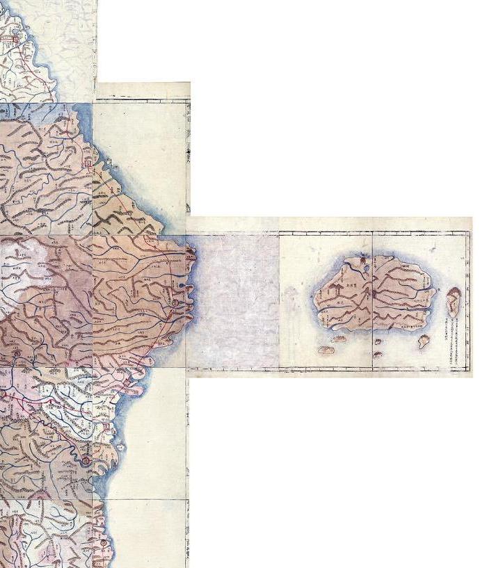
 The "Cheonggudo" (靑邱圖) was made in 1834 by Kim Jong-ho (金正浩), one of Korea's most famous 19th century mapmakers. He also made the "Dongyeodo" (東與圖) and the "Daedongyeojido" (大東與地圖). He also made the following atlases: "Dongyeodoji" (東與圖志 - 1834), "Yeodopigi" (與圖備志), "Daedongjiji" (大東地志 - ca. 1866)
The "Cheonggudo" map is 8.7 meters tall and 4.62 meters wide and is the largest of Korea's old maps still in existence. The map is made up of hundreds of ruled paper panels. It is twenty-nine panels high and twenty-two panels wide. The height of each panel represents a measure of 100 ri (40 kilometers), and the width represents a measure of seventy ri (28 kilometers). The rule along the edge of each panel are measured in segments of ten ri (4 kilometers). That means the map shows the length of the Korean peninsula to be about 3,000 ri, and its width to be about 1,500 ri. The scale of the map is about 1/216,000th of actual size.
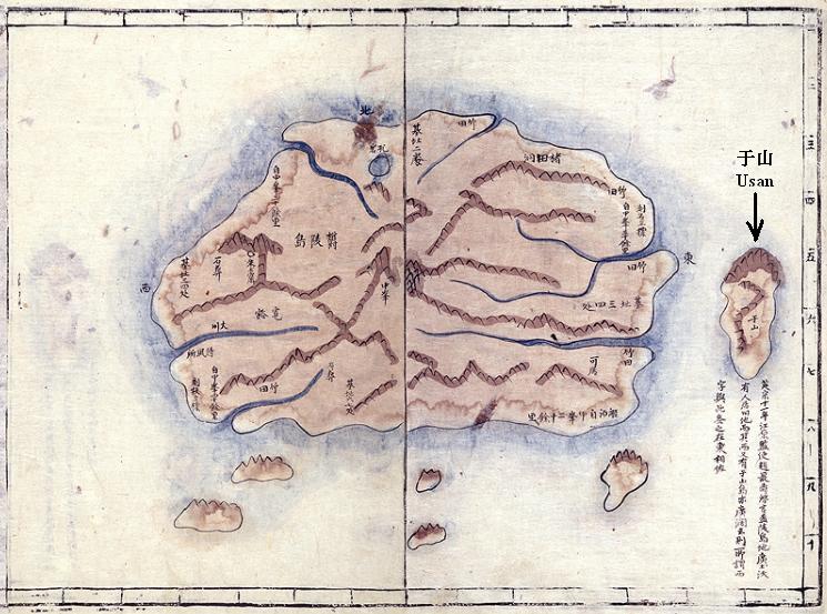
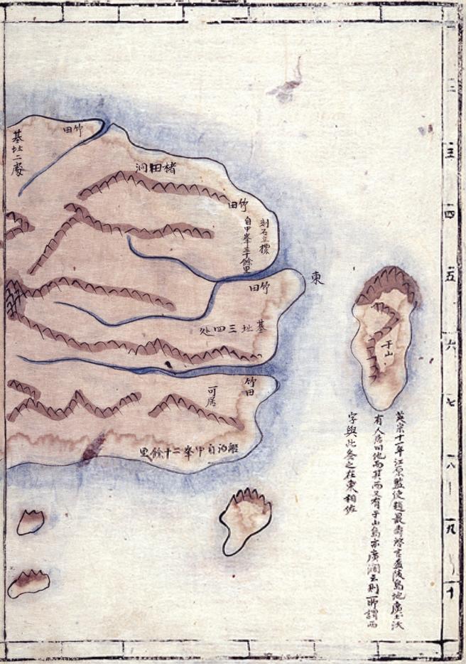
In one of the scans belows, you can see that two panels were used to represent Ulleungdo. Usan (于山) was drawn about one 10 ri (4 kilometers) segment off the east coast of Ulleungdo. Koreans claim that Usando (于山島) was the old name for "Dokdo" (Liancourt Rocks), but this 1834 map shows that Usando was almost certainly Ulleungdo's neighboring island of Jukdo (竹島), which is about 2.2 kilometers off of Ulleungdo's east shore. The islands to the south of Ulleungdo were probably misdrawn since they most likely were supposed to represent the rocks off the northern shore of Ulleungdo, not the southern shore.
By the way, the Chinese text under the island labeled as "Usan" on the Ulleungdo map reads as follows:
“In the 11th year of Yeongjo (1735), Gangwon Provincial Governor Jo Choi-su reported to the king, ‘A survey of Ulleungdo has found that the land is wide and fertile, and there are signs that people have lived there. Also, to its west is Usando, which is also wide and spacious.’ The so-called “west” character is different on this map, where (Usando) is to the east.”


Gerry,
ReplyDeleteDo you have the clear text which can read all of the writings beside Usando?
The first part reads 英米11年江原監使....so it may mentioning the incident when the inspector from 江原道 came to Jukdo and found people there.
pacifist,
ReplyDeleteI can't see clearly, but it looks like the sentence is about 鬱陵島, not 于山島(Jukdo).
By the way, we can see forests on Usando. And 6 small and big islands around Ulluendo and the biggest island is Usando. It reminds me of two documents.
1) An article from 皇城新聞 in August 1899 says that there are 6 small and big islands around Ulleundo and prominent among them was UsandoJukdo.
2) A book 恒屋盛服「朝鮮開化史」1901 which explains that"大小六島あり其中著名なるを于山島(日本人は松島と名く)竹島と云ふ"(There are 6 large and small islets. The largest one is called Usando (Japanese call Matsushima)-Takeshima(Jukdo).)".
Is it possible that this map had influence on the expressions of those documents and 1900 Ordinance 41?
Kaneganese,
ReplyDeleteThanks, you are right. It says Ulleungdo - broad and rich soil...and after that it mentions 又有于山島 (there is also Usando). I can't read after that.
There is clear one and translation below:
ReplyDeletehttp://www.occidentalism.org/?p=328
英宗11年=1735?
Other discription in 1735
備辺司謄録 英祖11年1月
又所啓, 江原監司趙最壽?啓, 鬱陵島搜討, 今年當擧行, 而道?農事不免慘凶, 往來時所入雜物, 皆出民間, 營將及倭學等, 所率甚多, 累朔候風, 所費不貲, 當此荒年, 必多騷擾, 今年姑爲停止, 待年豐擧行事陳請矣, 今年關東年事, 果爲凶歉, 多人治送, 累朔候風, 不無弊端, 而此是定式以三年一往者也, 昨年?不得擧行, 今年又爲停止, 則雖無當初定式之意, 何以爲之, 上曰, 此事何如, 行左參贊金取魯曰, 丁丑・戊寅年間朝家送張漢相, 看審圖形以來, 而聞鬱陵島, 廣闊土沃, 曾有人居基址, 或有往來之痕, 其西又有于山島, 而亦且廣闊云矣, 其後仍有三年一搜討之定式, 此與年例操停止有異, 事係海防申飭, 恐不當以本道凶歉些少弊端, ?年停廢矣, ?曹判書李廷濟曰, 往在丁丑年間, 倭-人請得鬱陵島, 故朝家嚴飭不許, 而使張漢相往見此島, 三年一往仍爲定式矣, 本道凶荒, 固爲可念, 而此事之??停廢, 亦甚可悶矣, 上曰, 兩重臣所達是矣, 候風雖有弊, 而此蓋憚於越海不欲往見之致也, 此地若棄之則已, 不然, 豈可不爲入送耶, 今年則搜討事擧行之意, 分付可也。
GTOMR,
ReplyDeleteThanks a lot!
The parts from the document; "江原監司趙最壽?啓, 鬱陵島搜討" and "而聞鬱陵島, 廣闊土沃", and "其西又有于山島, 而亦且廣闊云矣" etc resemble the text in the map.
Sorry, it says about Usando,too.
ReplyDelete"其西又有于山島, 而亦且廣闊云矣"
It says that Usando is also fertile!!
英祖十一年 江原監司趙最壽啓言 盃(鬱)陵島地廣土沃有人居田他而其西又有于山島 亦廣闊云則所謂西字與此各之在東相佐
ReplyDeleteThis is what I read. I hope someone correct it.
The text below Usando translates as follows:
ReplyDelete“In the 11th year of Yeongjo (1735), Gangwon Provincial Governor Jo Choi-su reported to the king, ‘A survey of Ulleungdo has found that the land is wide and fertile, and there are signs that people have lived there. Also, to its west is Usando, which is also wide and spacious.’ The so-called “west” character is different on this map, where (Usando) is to the east.”
Regarding from the Old detail maps of Ullungdo by Korean, the concept of Ulleungdo seems to be ,
ReplyDelete鬱陵島 + 小6島(最著者于山島+小5島)
Ululngdo + Small six adjunctive islands/rocks(Most prominent island of Usando + 5small islands)
Thank you, Gerry.
ReplyDeleteYes, "闊" means spacious, not fertile. But it still doesn't fit the description of 竹島/Liancourt Rocks/Dokdo. It it apparently Jukdo which has an spacious land on the top. On the other hand, 竹島/Liancourt Rocks has no broad space.
GTOMR,
It's a very interesting obsevation. So those maps below described Ulleundo as main island plus 6 islets including Usando as a prominent one.
鬱陵島圖形(c.a1711/1823)
輿地圖(c.a.1736-67)
海東地圖(c.a.1750's)
大東總図(海東地図)
地乘(c.a.1776-1800)
廣輿圖(c.a early in 19 Century)
靑邱圖 (1834)
大東興地圖の筆写本(1861)
朝鮮地圖(1860頃)
大韓全図(1899)
大韓地誌江原道図(1901)
It(the conception of Ulleundo as main island plus 6 islets including Usando(Jukdo) as a prominent one) could be started by 朴昌錫's inspecion on Ullundo and his map(鬱陵島圖形(c.a1711)).
And your observation of ”倭船倉可居” near 于山島 in Ⅵ.大東總図(海東地図) is also interesting. It supports Japanese were docking their ships at Jukdo and Ahn's testimony of there were Japanese on Usando(Jukdo).
By the way, Gerry said 朝鮮地圖 was made between 1750-1768年 here, and you say "Ⅴ.1860年頃 朝鮮地圖". What do you think ? (細かいことですみません。)
Kaneganese-san,
ReplyDeleteYes,as far as i know, the map by korea, the Small six adjunctive island incrudes most prominent Usando is shown after 1700’s,especially details map of Ullungdo,not whole chosun maps.
I guess the reason Chosun dynasty increase sending inspectors and more detail inspection result after Takeshima(Ulleungdo) Incident late of 17 century.
Except most prominent adjunctive island of Usando, there are not many hints of other 5 adjunctive small islands/rocks from other Korean old maps. Most of them shows Usando in the east of Ullungdo and two rocks nearby Cape Seal,mahybe one in front of Cape seal and other is Turtle Rock.Twoo in front of 道洞 seems to be 北亭岩 and 瓮岩.But I don't know other one rocks betweeb Usando and 道洞.
Mostly the location in mainisland is same but different of adjunctive rocks in each maps.I think they wrote mainland first, then they add the adjunctive rocks when they records the geography or create the maps.
It reminds me that Japanese langing on Iga-shima considered as JUKDO today, when I check 倭船艙 in 大東総図.
I hope korean not to burn old maps anymore,especially Ullungdo's local maps considered written by inspectors.
And thx for yr suggestion ,朝鮮全図 1750-1768.c.a. is right.
GTOMR wrote,
ReplyDelete"It reminds me that Japanese langing on Iga-shima considered as JUKDO today, when I check 倭船艙 in 大東総図."
I think this is a great finding and is one of the proof of Japanese sovereignty over Takeshima/Liancourt Rocks/Dokdo from Korean side. If Usando was Takeshima/Liancourt Rocks as Korean says, it proves Korean officials recognized Japanese were using the island as their boat dock. And if it were Jukdo as we say, well, not only it shows that Ahn's Usando was Jukdo, but also all the bases Korean rely on simply dissapear.
"And thx for yr suggestion ,朝鮮全図 1750-1768.c.a. is right."
Actually, I thought your year was right, since it has grids on it and looks much new.
Thank you, anyway. I think you have special talent in maps. Sometimes, I don't follow what you are trying to say, but I think your perspective is very unique and interesting. Please keep commenting.
Gerry,
ReplyDeleteI don't know whether this map is helpful but, to follow is the 1929 map of Chosun. There is no Liancourt rocks although Ulleungdo can be seen.
http://www.asocie.jp/map/oldmap/gaichi/image/50011.jpg
My post on 2:41 AM has some error.
ReplyDelete>It reminds me that Japanese langing on Iga-shima considered as JUKDO today, when I check 倭船艙 in 大東総図.
It is not Igashima but Mano-shima considered as Jukdo today,most prominent surrounding small island/rock around Ulluengdo ,not only on Korean maps Japanese Map as well. But,in Some Japanese map has two Mano-shima and some Japanese maps are no name attached.
On the other hand, Matsushima's name(Liancourt Rocks) in those map,Japanese clearly recognized the location,shape and the name.
GTM;
ReplyDeleteYou didn't make mistake. Japanese called Jukdo Iga-shima and Mano-shima as well. Murakawa clan said that they docked their boat at Igashima when they saw Korean are fishing on Ulleundo in 1692. I first thought Mano-shima in later maps is 観音島, but it was used for Jukdo. Gerry wrote the article.
What do イガ島, まの島 and マノ島, have in common?
日本語/Japanese
Pacifist,
The map you showed us is very beautiful. It is like a Ukiyoe.
This comment has been removed by the author.
ReplyDelete