Sadly, Japanese Government expends only about 10 million yen (90,000-100,000 U.S. dollar) a year though the South Korea government put a huge budget to the Takeshima/Dokdo issue every year. Although Japanese government should be the one who are responsible for the territorial issue essentially, in reality, Shimane Prefecture, which is only one local government with very few budgets is forced to tackle this problem almost alone in Japan. I believe it is more necessary to inform international society of the excellent academic works done by Japanese researchers on this issue in order to let good Korean citizens realize that their governments' and academics' illogical claims over Dokdo/Takeshima cannot be accepted by international society and it is the best way to solve this issue peacefully at the court of ICJ.
The Web Takeshima Research Center, which had succeeded the research activity from Takeshima Research Group of Shimane last year, has lots of interesting articles on their site, which Japanese researchers from many specialized field studied and intensively wrote from many perspective. Luckily, we had a permission to translate and post them on this site recently. Though it is impossible for us to translate all of their fantastic reports, we are honoured to be going to choose some of them and post one by one.
As for the starters, I picked the article 「朝鮮側作製の官製地図にみる竹島(Takeshima in the Korean official map)」 by associate professor Funasugi Rikinobu (舩杉力修) of Shimane University. In the final report by Takeshima Research Group submitted last year, he studied many Korean old maps. But in this article, he selected 5-6 official Choson maps or maps made by Korean officials as a counterargument against the false claim that Japanese official maps in Edo era and Meiji era didn't include Takeshima/Dokdo, leaving false impression as Korea had any maps which include Takeshima/Dokdo in their official maps, by Prof. Hosaka Yuuji of Korean 世宗大学.
1) 「八道総図」 in 『新増東国輿地勝覧』 - "Takeshima in the Korean official map" by Funasugi Rikinobu (舩杉力修)
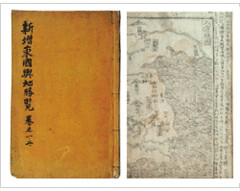
This is not the map based on the actual measurement or survey, but it is merely the main name of a place or roads were recorded. If you look at the text in 『新増東国輿地勝覧』 itself, the description of Ulleundo is under the Uljin Prefecture, and it clearly says that "Usando, Ulleundo. It is called 武陵 and also called 羽陵. Two islands are in the due East of the Sea of Uljin 縣. ... When it is a fine day, the trees on the mountain and the roots of mountains and seashore can be seen."
According to the analysis by Prof. Shimojou in 2005, this sentence means that two islands should locate in the order of Usando first and Ulleundo next from Korean peninsula and those two islands should be seen from Uljin which locate at mainland of Choson, because there was a "rule" that becomes an edit policy in the compilation of topography document in Choson dynasty, and there also was a principle that describes the distance from the land, clearly in case of the description of islands. The island (Usando) seen from Uljin seems to indicate Ulleundo because there is actually no island between and Ulleundo. Therefore, it is understood that the description of this map was not the one based on an actual field investigation but the one based on the description in the topography documents.
Thus, from this map, it can be said that geographic recognition around Ulleundo by Choson dynasty was not accurate at that time. It is thought that this empty island policy by which Choson dynasty prohibited their people from entering and the residence to Ulleundo after 1417 is related. The investigation to the island was done by a Choson dynasty at intervals of several years. In Choson dynasty's authentic record (朝鮮王朝実録), we can find the descriptions of the islands such as 于山島、武陵島, which is thought to be present Ulleundo from the content of the description. Therefore, it can be said that this map doesn't show that it recognized that there were two island in the Sea of Japan, but only shows that their recognition of the Ulleundo itself were confused.
*Related articles
Lies, Half-truths, and Dokdo Video, Part 1 : Propaganda video, 朝鮮王朝実録, 八道総図 (1530)
「朝鮮側作製の官製地図にみる竹島(Takeshima in the Korean official map)」 by associate professor Funasugi Rikinobu (舩杉力修) of Shimane University.
Translated by Kaneganese.
Courtesy of Web Takeshima Research Center.
Gerry and pacifist,
ReplyDeleteCould you please check my translation when you have time? Thank you.
Good job, Kaneganese!
ReplyDeleteBTW, the Japanese version of the posting has a little misprint - "必死" should be "必至".
pacifist,
ReplyDeleteThank you ! If you find anything, please let me know.
Kanganese, this map shows us one thing for sure. The Koreans have a far stronger historical claim to the Dokdo region. Even though this map is not the earliest Korean record is shows the Koreans were administering over Ulleungdo at least 100 years before the first Japanese accidentally voyaged there.
ReplyDeleteSo what we have is the Korean government having incorporated Ulleungdo island (Laincourt Rocks most proximal land mass) within visual proximity of Dokdo at least a century earlier than the Japanese.
Kanganese, the reason the Japanese government doesn't back Shimane's lobbying is because they know they have no right to Liancourt Rocks. They also know the Koreans will never give up this island.
However Shimane is a backwater province whose cabinet is so thick-headed they would rather put their own selfish needs ahead of Japan ~ Korea relations. In fact, when Shimane foolishly declared "Takeshima Day" in 2005, Japan's national government was openly opposed to the plan.
The Japanese Takeshima lobbyist are shooting themselves in the foot. They are trying to disclaim Korea's claim to Dokdo by posting ancient Chosun documents. However, they are inadvertently building an iron-clad proof of Korean administration over the region centuries before the first clumsy Japanese happened into the region in a storm in 1618.
In short, the Japanese are trying to re-annex an island located within visual proximity of Korean territory since the 6th Century!! Ain't gonna happen Kaneganese.
Ulleungdo from Dokdo1
Ulleungdo from Dokdo2
Dokdo from Ulleungdo
Ulleungdo and Dokdo ancient sisters that will always be together.
Steve Barber,
ReplyDeleteIf real Liancourt rocks locate in the middle of Korean peninsula and Ulleungdo as the map shows, your opinion may be right. But Liancourt rocks don't locate at such a place. And the shape of Liancourt rocks is totally different from the map.
Look at the map Steve with holding your glasses tightly. Usando in the map was not Liancourt rocks as normal persons with normal sight should easily recognise.
Steve, why are you so eager to insist such unreasonable theories? What do you want? What for are you telling these unreasonable things?
Pacifist don't put my head in the noose of some Koreans. I dont' hold tight to some Korean theories that Usando is always Liancourt Rocks and you shouldn't dodge those that imply otherwise.
ReplyDeleteWhat I hold steadfast to is what is clear. Koreans have an ironclad claim to Ulleungdo which is Liancourt Rocks closest land mass, since at least 1500 years ago. This is indisputable. Knowing this, how can Japan demand she be allowed to extend her boundary another 160kms to within 87kms of Ulleungdo. It doesn't make sense Pacifist and this is why nobody in their right mind will ever support Japan's claim.
Now when Japan annexed Liancourt Rocks in 1905 it really wasn't a big deal. Japan already had uncontrolled access to the whole Korean peninsula and her surrounding waters, so there really wasn't much of a boundary between Japan and Korea at all. But over a century later Japan still demands to re-impose these boundaries?? Get real man!
Considering the reality of northeast Asia in 2008 don't you think this is absurd? It's like trying to resurrect Checkoslovakia or Yugoslovakia. Geographic features remain static, however national boundaries are fluid and based on the political situation of the day. You can't define today's national limits on yesteryear's politics.
I'm sorry Pacifist, it is you that is unreasonable. You wish to jump into your Meiji Era time machine, revisit Japan's "glorious" expansionist colonial past and redraw a map of Asia on these circumstances. Take off your rising sun headband Pacifist it's 2008.
This comment has been removed by the author.
ReplyDeleteSteve Barber,
ReplyDelete"Considering the reality of northeast Asia in 2008 don't you think this is absurd?"
I completely agree with you.
Now that it has been clear that Korea has no right to own Liancourt rocks, Korea should admit that Rhee Syngmann took mistake to take one of the Japanese islands. To admit one's sin is the fastest way to reconciliation, which may be good to the peace in northeast Asia.
Pacifist, read my quote again and stop playing childish games by partially quoting me. As I've said, In 1905, when Japan annexed Liancourt Rocks the Japanese had a strong military presence on Ulleungdo Island. The Japanese had numerous concessions and control over numerous affairs in Korea both financially and politically.
ReplyDeleteThe political situation in Korea and Asia in 1905 was worlds apart from the reality of 2008. Korea is a free country now, 10,000 people live on Ulleungdo and utilize the seas surrounding the island for their income.
It's unthinkable that Japan would extend her border another 160kms (only 87kms) to Ulleungdo. Also consider Takeshima itself would need a boundary extending probably another 12kms putting the Japanese limits right on Korea's front door. This is a ridiculous proposition, it would create a nightmare scenario not to mention the potential for naval confrontations and renewed friction.
Pacifist says "To admit one's sin is the fastest way to reconciliation, which may be good to the peace in northeast Asia..."
Yes, I agree, so please pass these links on to your bosses in Japan's MOFA.
Japan's Sins 1
Japan's Sins 2
Japan's Sins 3
Japan's Sins 4
Japan's Sins 5
Pacifist, the line Syngman Rhee set up is really the same as the boundary drawn in maps of that accompanied the 1951 draft of the San Francisco Peace Treaty. The boundary he made is identical to the boundaries the British government lobbied for.
Stop the rhetoric by making radical statements.
Steve Barber,
ReplyDeleteI won't argue about militarism and situation of Korea in the early 20th century. We are only argueing about Liancourt rocks.
We are saying that, as for Liancourt rocks, Korea has no right to claim. Rhee Syngmann stole the island although USA tried to persuade him not to do that.
Rhee himself knew what he was doing was stealing because it is now clear from official documents that USA let them know the truth beforehand.
So Rhee Syngmann is to be blamed. The Korean governments after Rhee also took mistake to cover up the Rhee's sin.
We only want to clarify the mistake Korea had taken. To admit that will lead to true friendship of the two countries.
Pacifist, I'm not here to "argue" with you about Japan's military involvement I'm here to present this data. This is to show the fine folks at Shimane Prefecture the real world can see the truth about Japan military and expansionist involvement in the annexation of Liancourt Rocks. Others who are not right wing radicals like you can see this data and make their own determinations.
ReplyDeletePacifist you have to understand America was not, and is not God. I've shown you the process by which the allies reached their decisions in determining ownership of Japan's outlying islands. They were often military decisions and as I've shown Liancourt Rocks was no exception.
Many countries especially regional ones such as China, Russia North and South Korea had problems with the decisions the allies made. India, Burma and Yugoslavia also refused to participate. In other words none of Japan's Asian neighbours had any say on the Disposition of Territories in Article 2 of the S.F. Peace Treaty at all. Still to this day Asian countries dispute many parts of the San Franciso Peace Treaty.
So really Korea should be admired for taking the bull by the horns and claiming Dokdo when she did. America and allies are not the moral authority in deciding the boundaries of Asian nations. Korea should not be vilified and portrayed as a rogue state for having the guts to stand up and not be dictated to by Uncle Sam. Can you imagine China marching into New York State and drawing the Great Lake's boundary between U.S. and Canada?
Korea learned her lesson well. In 1907 the West turned her back on Korea at the Hague when Korea begged for help to remain independent. Never let another nation determine your fate. Ever.
Japan in Korea
Korea in 1905
Steve Barber,
ReplyDeleteI repeat once again that USA was the most important country in the SF peace treaty.
USA was in the impartial situation because Japan was her enemy, USA couldn't show partiality to Japan.
However, when Korea claimed that they wanted to get Liancourt rocks, USA examined the records and concluded that liancourt rocks hadn't ever included to Korean territory before. USA rejected Korean claim.
Steve, you must recognise that USA paid very careful attention when they transmitted this fact to Korea, because they had to fight with communists together. But this modesty was misunderstood by Rhee Syngmann - he thought that USA wouldn't fight back if Korea took the island from Japan. This was the beginning of the Takeshima dispute.
Pacifist, not all American's agreed that Japan had the only historical claim to Dokdo. Some sided with Korea's historical claim to Liancourt Rocks. As you can see by Mr Steeve's memorandum. You can also see, that Allied Military policy took precedent over historical title in the negotiation process. Read this.
ReplyDeleteSteeves Memorandum
A good comparison would be Marcus Island. Japan annexed Marcus Island in 1898 in much the same manner that Liancourt Rocks was seized. However, the Allies did not return Marcus Island to Japan. Why not? Because America wanted osme of Japan's outlying islands for military naval bases. This can be read in the following memorandums later on in the San Francisco Peace Treaty's archives.
Marcus Island 1
Marcus Island 3
The U.S. may have been in an impartial position, however, records show their decisions were strongly, if not solely influenced by military decisions NOT true historical records. Japan was America's enemy, but she had no power to dispute allied command's decisions. America was rightfully worried Korea would fall to Chinese communists so she sided with Japan. This is shown in San Francisco Peace Treaty records that were pondering even giving Cheju Island to Japan.
Japanese Chejudo ?
Pacifist, it's time you accepted the truth of the San Francisco Peace Treaty. The Takeshima documents that are cited here are only American confidential decisions all based on military decisions.
Steve
ReplyDeleteGet Gerry back on line, will you?
You miss him, don't you?
I have an important message to him.