竹島問題の歴史

31.10.10

1893 Map of Samcheok (三陟) and Ulleungdo (鬱陵島)

Below is a map of Samcheok (三陟 - 삼척) and Ulleungdo (鬱陵島 - 울릉도), from the 1893 atlas "Yeoljae Chwalyo" (輿載撮要 - 여재촬요). The map shows that Ulleungdo was associated with Samcheok in 1893. The map also shows a single island off Ulleungdo's east shore labelled Usan (于山). Usan was the old Korean name for Ulleungdo's neighboring island of Jukdo (竹島), which is 2 kilometers off Ulleungdo's east shore.

The map is important because it shows that Ulleungdo's neighboring island of Jukdo was still being referred to as Usando in 1893, ten years after Ulleungdo was opened to settlement.


Below is a similar map, which was made sometime between 1888 and 1894.


Thanks, GTOMR, for telling me about the 1893 map.

30.10.10

Joseon Paldo Jido (朝鮮八道地圖) - Ulleungdo (鬱陵島)

The following is a map of Ulleungdo, from a book entitled "Joseon Paldo Jido (朝鮮八道地). It is a cutout from a map of Pyongando (平安道), Hwanghaedo (黃海道), and Gangwondo (江原道). As far as I know, the date of the map is unknown. The map is stored in the Kyujanggak Institute for Korean Studies at Seoul National University.

Notice that it shows a small island just off the east shore of Ulleungdo labelled 于山 (Usan). Today, Koreans call the island Jukdo (竹島 - 죽도), which is about two kilometers off Ulleungdo's northeast shore. Some Koreans claim that Usan was the old Korean name for Liancourt Rocks (Dokdo / Takeshima), but there is no Korean map or documentary evidence to support the claim.


Let me know if this map has already been posted here.

28.10.10

1950 -中央人民政府人民革命軍事委員会作戦部測絵局 『朝鲜地图』 - People's Republic of China excluded Takeshima/Dokdo from " Map of Korea"

It looks like 中華人民共和国 (People's Republic of China) considered Ulleungdo is the easternmost of Korea.

1950.09.朝鲜地图 中央人民政府人民革命軍事委員会作戦部測絵局 新華書店
1950 Sep. 朝鲜地图 中央人民政府人民革命軍事委員会作戦部測絵局 新華書店

1950.朝鮮民主主義人民共和国新地圖 中国史地学社刘思源、董石声编制,金擎宇校订
1950 朝鮮民主主義人民共和国新地圖 中国史地学社刘思源、董石声编制,金擎宇校订

1950.07.28 最新朝鲜形势地图(1950年7月28日初版) 上海 百新书店 新文化书社 锦章书局 联合出 编绘者 杨景雄
1950 Jul. 28 最新朝鲜形势地图 上海 百新书店 新文化书社 锦章书局 联合出 编绘者 杨景雄

Thanks for the information, GTOMR !!

1.10.10

Are Koreans still interested in "Dokdo"?

In August 2009, the hit counter for this site showed more than 1.1 million hits, most of which were probably from Koreans coming to this site to vote in an online survey asking if Liancourt Rocks (Takeshima/Dokdo) belonged to Korea or Japan.

Before 2009, there was a great deal of Korean media and public interest in the Takeshima/Dokdo dispute, with almost weekly reports on Korean "Dokdo" protests or on some "newly discovered" map supposedly "proving" Korean claims, but that all but ended in 2009. Now the Korean media and Dokdo advocates have pretty much gone silent on Dokdo. Why? And what has happened over the past year?

Sometime in September 2009, our hit counter mysteriously reset itself from about 1.1 million hits to about 12,000. Today, our hit counter shows over 100,800 hits, which means that over the past year, this site has had about 88,000 hits. That averages out to about 240 hits a day for the past year, which is a pretty respectable hit count. Therefore, there still seems to be some interest in the Takeshima/Dokdo dispute, but it seems to be silent interest on Korea's part. Koreans and their Dokdo advocates no longer come to this site to argue Korea's silly claims. Why? Probably because they no longer believe them, though they will probably never admit it.

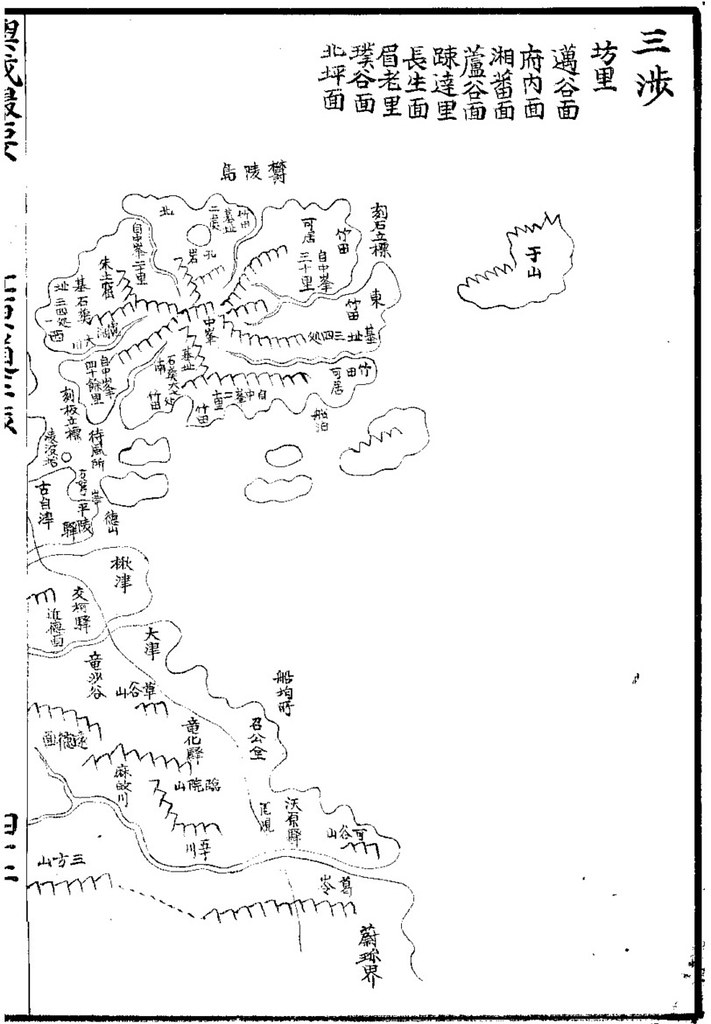
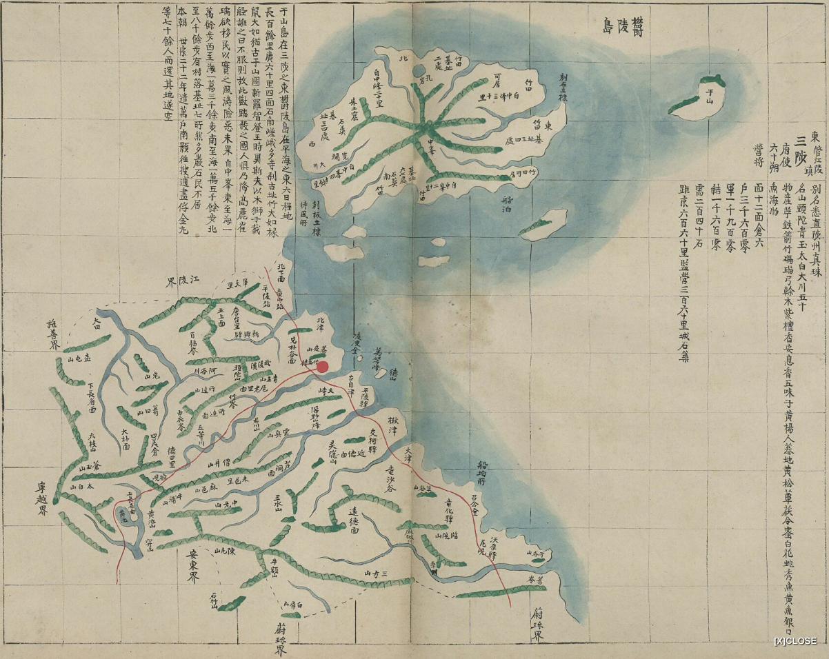
I think the Korean media and Korea's Dokdo advocates have gone silence on "Dokdo" because they and the Korean government finally came to realize that making "Dokdo" an issue was hurting Korea more than helping her. Thanks to this site and others, Korean historical claims on Dokdo have been shown to be false by using Korea's own documents and maps. Few Koreans are still arguing Korea's wild Dokdo claims because evidence disproving such claims is now scattered all over the Internet.

Japan may never get back the islands that Korea illegally occupied in the 1950s, but, at least, the world is slowly coming to realize the truth about Korea's false historical claims.

1893 - Lanier "L'Asie" excluded Takeshima/Liancourt Rocks (Dokdo) from Korean territory

1893 L'Asie, choix de lectures de géographie... par M. L. Lanier
This French book of Geography "L'Asie, choix de lectures de géographie-Deuxième Partie" was written by Lanier, Lucien (1848-1908) in 1893. (There are more editions as 1892, 1908 on Google books.)

The description of the Korean geography only describes "Korean peninsula", but the description of the "islets", as shown below, included Dagelet/Ulleungdo/Matsushima, but not "Liancourt Rocks" which was found and named by French in 1949. However, the map attached to the book clearly excluded Liancourt Rocks from Korean territory. Apparently, the author Lanier considered Liancourt Rocks is not Korean territory.

La Corée.

I. Geographie Physique

Limites; situation; étendue. -La presqu'île de Corée...Elle est comprise entre 34°20′et 42°30′de latitude nord, entre 122°15′et 127°14′longitude est. ...
( 127°14’ E+ 2°20’(Eastern longitude of Paris) = 129°34’E (Greenwich Meridian))

Littoral; îles
...Telle est L'île. Matsou-Sima ou Ollouto, que La Perouse découvrit en 1787 et appela Dagelet, haute de 1219 mètres, et couverte de forèts utilisées par les Japonais pour la construction de leur établissment de Gensanshin, dans la baies Broughton; telle aussi, ...

1893 L'Asie, choix de lectures de géographie... par M. L. Lanier_p_La Coree
1893 L'Asie, choix de lectures de géographie... par M. L. Lanier_p644_La Corée, le littoral de la mer Jaune (carte en couleur)
The Volume I of the book is available on Google Books. "L'Asie: Choix de lectures de geographie, accompagnées de résumés, ..."

References;