3) 「欝陵島図 in 『朝鮮地図』
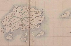
This map also describes the island labelled as "Usan" about 30里 of Ulleundo on the east side, Both Mr. Bevers and Kyujangkak of Korean study center of Seoul National University admit that this island "Usan"is not a present Takeshima/Liancourt Rocks/Dokdo but the Jukdo which locates in the 2km east of Ulleundo. In a word, present Takeshima/Dokdo is not drawn in figure on this official map of 8 prefecture of Choson made by a Choson dynasty, and it is understood that "Usando" which South Korea insists to be today's Takeshima/Dokdo is actually another island.
*Related articles
1750~1768 - Joseon Jido (朝鮮地圖) - Ulleungdo
Lies, Half-truths, and Dokdo Video, Part 8 : "An Yong-bok, Usando, & Matsushima (Songdo)" 肅宗実録(1696), 鬱陵島圖形(1711), 鬱陵島事蹟(1694), 海東地圖(1750s), 輿地圖(1736-67), 朝鮮地圖(1750-1768), 地乘(1776-1800), 東國文獻備考(1770), 日省録(1793), 萬機要覽(1808), 靑邱圖(1835), 朝鮮国交際始末内探書(1869), 高宗実録(1882), 鬱陵島外圖(1882), 大韓全図(1899), 皇城新聞(1899), 大韓勅令勅令第41号(1900)
Lies, Half-truths, and Dokdo Video, Maps 5 : "Muleungdo (Ullengdo) “also called ‘Usan’” 東輿備攷(1682ca.)輿地圖 (ca. 1730), 地海東地圖(Early 1750s), 朝鮮地圖(1750 - 1768), 地乘(After 1776), 廣輿圖(early 19th century), 靑邱圖(1834)
「朝鮮側作製の官製地図にみる竹島(Takeshima in the Korean official map)」 by associate professor Funasugi Rikinobu (舩杉力修) of Shimane University.
Translated by Kaneganese.
Courtesy of Web Takeshima Research Center.
Gerry and pacifist,
ReplyDeleteCould you please check my translation when you have time? Thank you.