

Below is a list of old Japanese, British, French and even Korean books and documents that clearly excluded Takeshima/Liancourt Rocks/Dokdo (131º 52'E longitude) from Korean territory. There is no single, concrete document or map, whatsoever, that shows Korea had ever recognized the disputed island to be within their territory before Japan officially incorporated it into Shimane Prefecture in 1905.

Especially interesting among the books in the list is Choi Nam-seon's (崔南善) 1948 book, "Common Knowledge of Joseon" (朝鮮常識), which specifically says that Korea's easternmost island was Ulleungdo's "Jukdo" in North Gyeongsan Province (慶尚北道鬱陵島竹島). Jukdo is a small island located about two kilometers off Ulleungdo's eastern shore, which matches up with old Korean maps and documents that showed Usando (于山島) to be Korea's eastern most island. Though Koreans claim Usando was Korea's old name for "Dokdo," Korea's old maps and documents show that Usando was actually Ulleungdo's neighboring island of Jukdo, which is at an east longitude of approximately 130º 56' 23." Again, that longitude essentially matches up with longitudes mentioned in the documents below.
As we have seen, many western and Japanese maps around 1900 clearly depicted Takeshima(on-existant Argonaut), which is nearest to peninsula to be Korean, but other islands, "Matsushima(which is actually today's Ulleungdo)" and Takeshima/Liancourt Rocks, to be Japanese territory. It matchs with a fact that so many documents described Korean eastern limit as 130º 35' - 130º 50' which exclude whole or part of Ulleungdo.
1874 "Histoire de L'Eglise de Corée (History of the Korean Catholic Church) by Claude-Charles Dallet
130º 50' E. longitude (東経130度50分)
1876 "Keirinjiryaku(鶏林事略)" by Sewaki Hisato (瀬脇寿人)
130º 35' E. longitude (東経130度35分)
1880 "朝鮮地誌" by 坂根達郎
130º 45' E. longitude (東経130度45分)
1882 "The Joseon Situation" (朝鮮事情) by Enomoto Takeaki(榎本武揚) (Originally published in 1876-77)
130º 50' E. longitude (東経130度50分)
1887 "朝鮮八道誌" by 小松運
130º 35' E. longitude (東経130度35分)
1890 "外国地理" by 高木怡荘
130º E. longitude (東経130度)
1891 "受験応用万国小地誌" by 谷口流鶯
130º E. longitude (東経130度)
1894 "新撰朝鮮地理誌" by 大田才次郎
130º 35' E. longitude (東経130度35分)
1894 "朝鮮志" by 足立栗園
130º 36' E. longitude (東経130度36分)
1894 Jun. "朝鮮地理圖" by 岩崎茂吉
130º 35' E. longitude (東経130度35分)
1894 Jun "朝鮮地誌要略" by 松本仁吉
130º 35' E. longitude (東経130度35分)
1894 Jun. "新撰朝鮮国地図" by 林正
130º 35' E. longitude (東経130度35分)
1894 Nov. "朝鮮水路誌" by Waterway Section of Japanese Navy (海軍水路部)
130º 35' E.longitude (東経130度35分) (序 : 肝付兼行 海軍省水路部長 Preface by Kimotsuki)
1894~1897 "Korea and Her Neighbours" by Isabella Lucy Bird
130º 33' E. longitude (東経130度33分)
1895 "外国地誌" by 秋山四郎
130º 40' E. longitude (東経130度40分)
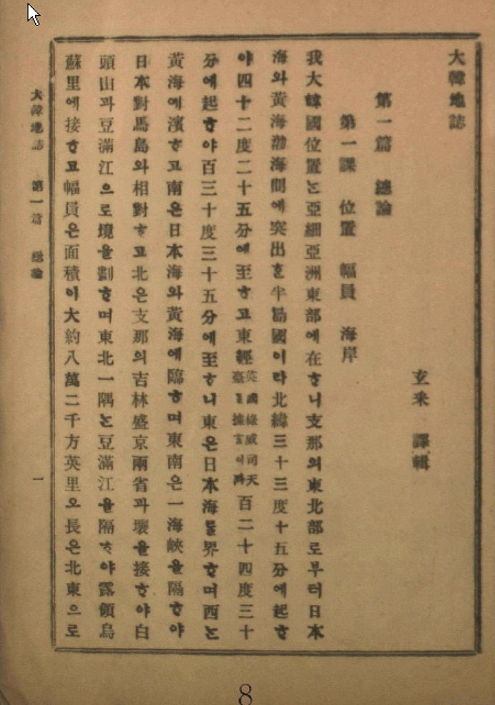
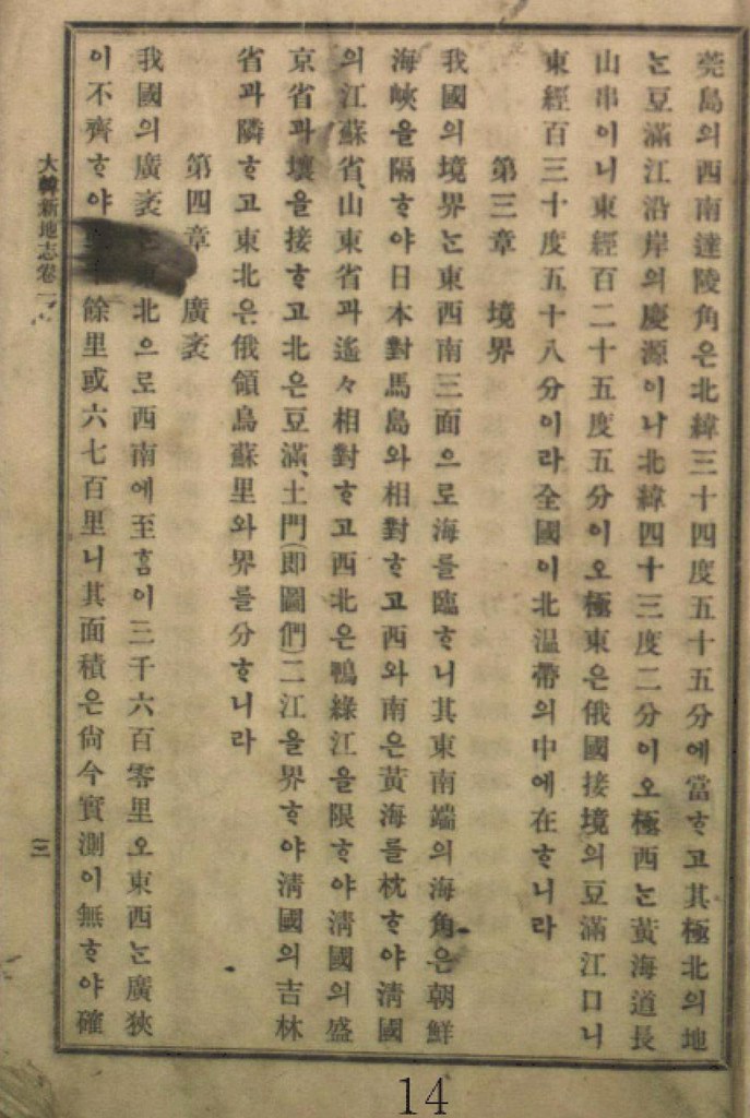
1899 "大韓地誌" by 玄采 (Korean Geography Textbook)
130º 35' E. longitude (東経130度35分)
1899 "新式万国地理" by 岩崎重三
130º 35' E. longitude (東経130度35分)
1900 "新撰大地誌 前編(世界之部)" by 山上万次郎
130º 35' E. longitude (東経130度35分 : 図満江〔註:豆満江) 教師用参考書)
1901 "大韓地誌" by 玄采 (Korean Geography Textbook)
130º 35' E. longitude (東経130度35分)
1901 "朝鮮開化史" by 恒屋盛服
130º 35' E. longitude (東経130度35分)
1902 "高等地理学講義" by 永田健助編
131º E. longitude (東経131度)
1902 "新撰世界地理問答" by 武田鶯塘
130º 40' E. longitude (東経130度40分)
1903 "韓海通漁指針" by 東京 黒龍会 葛生修吉
130º 35' E. longitude (東経130度35分)(序 : 牧朴真 農商務省水産局長 Preface by Maki)
1904 "韓国地理" by 矢津昌永
130º 58' E. longitude (東経130度58分)
1904 "最新韓国実業指針" by 岩永重華
130º 35' E. longitude (東経130度35分)(序 : 山座円次郎 外務省政務局長 Preface by Yamaza)
1904 "朝鮮移住案内" by 山本庫太郎
130º 35' E. longitude (東経130度35分)
1905 "日本民族の新發展場萬韓露領地誌" by 岡部福蔵
130º 35' E. longitude (東経130度35分)
1905 "韓国新地理" by 博文館
130º 58' E. longitude (東経130度58分)
1906 "大韓地誌" by 玄采 (Korean Geography Textbook)
130º 35' E. longitude (東経130度35分)
1906 "韓国水産業調査報告" by 農商務省水産局
130º 35' E. longitude (東経130度35分)
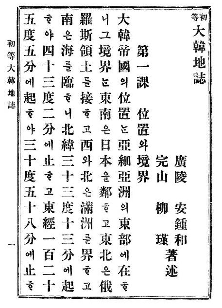
1907 "初等大韓地誌" by 安鍾和 (Korean Geography Textbook)
130º 58' E. longitude (東経130度58分)
1907 "大韓新地志" by 張志淵 (Korean Geography Textbook)
130º 58' E. longitude (東経130度58分)
1907 "外国地理表解" by 小林杖吉
130º 35' E. longitude (東経130度35分)
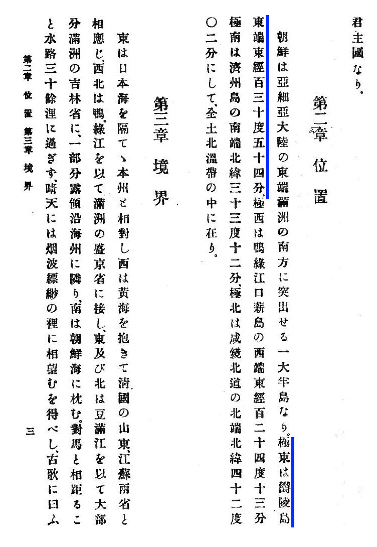
1908 "初等大韓地誌" by 安鍾和 柳柳瑾 (Korean Geography Textbook)
130º 58' E. longitude (東経130度58分)
1909 "最新高等大韓地誌" by 鄭寅琥 (Korean Geography Textbook)
130º 35' E. longitude (東経130度35分 慶尚南道鬱島郡鬱陵島 : Ulleundo, Ulleudo County)
1909 "韓国水産誌" by 統監府農商工部水産局
130º 42' E. longitude (東経130度42分)
1909 Mar. "大韓協会会報第12号 地誌" (Korean Geography journal) cache
130º 35' E. longitude (東経130度35分)
1910 Feb. "朝鮮新地誌" by 足立栗園
130º 58' E. longitude (東経130度58分)
1911 "朝鮮及南満洲地理教授備考" by 亀井忠一
130º 54' E. longitude (東経130度54分 極東 鬱陵島東端 : Easternmost of Ulleundo)
1911 "最新日本地理資料" by 井原儀
130º 54' E. longitude (東経130度54分 極東 鬱陵島(松島)の東端 : Easternmost of Ulleundo(=Matsushima))
1911 Apr. "大日本地理集成" by 矢津昌永等
130º 58 E. longitude (東経130度58分 豆門江の江口)
1911 "韓国通覧" by 統監府農商工部
130º 54' E. longitude (東経130度54分 鬱陵島東端 : Easternmost of Ulleundo)
1912 "最近朝鮮事情要覧" by 朝鮮総督府 2版渡辺為蔵
130º 54' E. longitude (東経130度54分)
1912 "小学地理教材" by 北垣恭次郎
130º 54' E. longitude (東経130度54分 鬱陵島の東端 : Easternmost of Ulleundo)
1912 "最新 朝鮮地誌" by 日韓書房編集部
130º 54' E. longitude (東経130度54分 鬱陵島東端 : Easternmost of Ulleundo)
1936 "朝鮮現勢便覧" by 朝鮮総督府
130º 56' 23" E. longitude (東経130度56分23秒)
1947 "朝鮮常識問答" (Qs & As for General Knowledge of Joseon) by 崔南善 (Korean Geography Textbook)
130º 56' 23" E. longitude (東経130度56分23秒 )
1948 "朝鮮常識" (General Knowledge of Joseon)" by 崔南善 (Korean Geography Textbook)
130º 56' 23" E. longitude (東経130度56分23秒 慶尚北道鬱陵島竹島 : Jukdo of Ulleundo, (*not Japanese Takeshima)
This is a revised version of Korean Eastern limits described in various books exclude Takeshima/Dokdo from Korean Territory, which is a re-revised version of "1894-1948 Korean territory (Revised version)," by Pacifist. As we can see, the oldest document now dates back to 1874 now. The newly added documents are marked red in their published year.
The Dokdo Islets, which had been part of Korean territory since the sixth century, were illegally occupied by Japan during the colonial period but returned to Korea under the Directive SCAPIN-677 issued by the General Headquarters Supreme Commander for the Allied Powers on Jan. 29, 1946, which specifically excluded Dokdo from Japanese territory. However, Japan continued to trespass into waters near Dokdo, marking it as Japanese.
To view the original letter, click HERE.Official - Informal
Confidential Security Information
Dear Al;
I have read both Tokyo's despatch No.659 of 3, 1952,of October 15, 1952, entitled, "Use of Disputed Territory (Tokto Island) as Live Bombing Area" enclosed in your letter of October 16, 1952 to Ambassador Murphy.
It appears that the Department has taken the position that these rocks belong to Japan and has so informed the Korean Ambassador in Washington. During the course of drafting the Japanese Peace Treaty the Republic of Korea's views were solicited, in consequense of which, the Korean Ambassador requested the Secretary of State in a
letter of July 19, 1951 to amend Article2 (a) of the draft treaty so as to include the islands of Dokdo (Liancourt Rocks) and Parangdo as well as Quelpart, Port Hamilton and Dagelet among those islands over which Japan would renounce right, title and claim by virtue of recognizing Korea's independence. In his reply to the Korean Ambassador the Secretary stated in a letter dated August 10, 1951 that the United states could not concur in the proposed amendment as it applied to the Liancourt Rocks since according to his information the Liancourt Rocks had never been treated as a part of Korea, they had been under the jurisdiction of the Oki Islands Branch Office of Japan's Shimane Prefecture since 1905 and it did not appear that they had over before been claimed by Korea. As a result Article2 (a) of the Treaty of Peace with Japan makes no mention of the Liancourt Rocks;"Japan, recognizing the independence of Korea, renounces all right, title, and claim to Korea, including the islands of Quelpart, Port Hamilton and Dagelet."E. Allan Lightner, Esquire
Charge D'affaires, a.i.,
American Embassy
,Pusan, Korea. page2Official - Informal
Confidential Security Information
The action of the United States-Japan Joint Committee in designating these rocks as a facility of the Japanese Government is therefore justified. The Korean claim, based on SCAPIN677 of January 29, 1946, which suspended Japanese administration of various island areas, including Takeshima (Liancourt Rocks), did not preclude Japan from exercising sovereignty over this area permanently. A later SCAPIN, No.1778 of September 16, 1947 designated the islets as a bombing range for the Far East Air Force and further provided that use of the range would be made only after notification through Japanese civil authorities to the inhabitants of the Oki Islands and certain ports on Western Honbu.
Sincerely yours,
Kenneth T. Young, Jr.,
Director
Office of Northeast Asian Affairs,
The Island of Dokto (otherwise called Liancourt and Take Shima) is in the Sea of Japan approximately midway between Korea and Honshu (131.80E, 36.20N). This Island is, in fact, only a group of barren, uninhabited rocks. When the Treaty of Peace with Japan was being drafted, the Republic of Korea asserted its claims to Dokto but the United States concluded that they remained under Japanese sovereignty and the Island was not included among the Islands that Japan released from its ownership under the Peace Treaty. The Republic of Korea has been confidentially informed of the United States position regarding the islands but our position has not been made public. Though the United States considers that the islands are Japanese territory, we have declined to interfere in the dispute. Our position has been that the dispute might properly be referred to the International Court of Justice and this suggestion has been informally conveyed to the Republic of Korea.Ambassador Van Fleet also wrote the following about Korea's so-called "Peace Line":
The position of the Republic of Korea Government has been to insist on the recognition of the agreed "Peace Line." The United States Government has consistently taken the position that the unilateral proclamation of sovereignty over the seas is illegal, without wanting to upset any of the two respective nations and that the fisheries dispute between Japan and Korea should be settled on the basis of a fisheries conservation agreement that would protect the interests of both countries. The chronology and other aspects of the fisheries is discussed in more detail in Enclosure No. 1.
Japanese Article
May 18 - "Takeshima is going to be described in the manual for teacher's guidebooks for Junior High School textbooks" - 読売新聞(Yomiuri Shinbun)cache
May 18 - "Takeshima is going to be described in the manuarl for teacher's gudebooks for Junior High School textbooks" - 産経新聞(Sankei Shinbun) cache
Below is a translation of The 11th column “Seeking Truth Based Solely on Facts(実事求是)” by Prof. Shimojo Masao
" South Korea's Misunderstanding of 'A Map of Three Adjoining Countries (Sangoku Setsujozu 三国接壌図)' by Hayashi Shihei(林子平)”"Chosun Ilbo" dated May 2 introduced the thesis by Hosaka Yuji of the Yonsei University, and reported "Edo Shogunate of Japan used the map which "depicted Dokdo as Korean territory" during the territorial dispute between America." According to the report, Mr. Hosaka claimed that when Edo Shogunate disputed over the sovereignty of Ogasawara Islands(小笠原諸島), which include Bonin Islands(無人島 : 小笠原群島), Shogunate used French version of “Sangoku Setsujozu” as a basis for its' sovereignty. And he continued that this makes Hayashi's map, which "depicted Takeshima as Choson's territory" an official map, thus it is considered that Bakuhu then already recognized Takeshima as Choson's territory in 19C.
However, there is no historical grounds in Mr. Hosaka's claim. In November 1861, Edo Shogunate notified to each minister of both U.S. and Britain in Japan that that foreign magistrate (外国奉行) Mizuno Chikugonokami Tadanori (水野筑後守忠徳) and superintendent (目付) Hattori Munekazu ( 服部帰一) would head to investigate Ogasawara island. But in his reply letter, Harris, a U.S. minister to Japan, stated Ogasawara island as Japanese territory and only requested Shogunate of the rights of the American who reside on the island. Apparently, there were no such things as "territorial dispute between America". Because Ogasawara island(小笠原島) was widely recognized as Japanese territory among foreign countries, as is seen in the Mizuno's letter "The letter of the planned expedition to the islands of Izu Country on behalf of Shogunate"("伊豆国附島々其外へ御用のため差遣され候につき見込の趣申上候書付")" in October, which was submitted to Bakuhu. It said that "As for Ogasawara island(s), Dutch and other countries' books state that it is Japanese island. Foreigners certainly recognize this. (小笠原島の儀、御国属島の儀と蘭書等にも相見へ、外国人ども弁知罷り在り候)"
It is also confirmed by Commodore Perry's "The Japan Expedition, 1852-1854 The Personal Journal of Commodore Matthew C. Perry." or "Narrative of the Expendition of an Squadron to the China Seas and Japan (1856)". In the book, Commodore Perry quoted translated version of Hayashi's “Sangoku Tsuran Zusetsu (三国通覧図説) ” and clearly stated that "It is quite clear that the Japanese were the first discoverers of these islands." Hosaka's claim that "Edo Bakuhu(Shogunate) used French version of “Sangoku Setsujozu” as a basis for sovereignty over Ogasawara Islands" is apparently nothing but just a fictitious story, or fantasy.
Likewise, his claim “ 'Sangoku Setsujozu' depicted Takeshima as Choson's territory" is groundless from the view of historical facts, since there is no Takeshima/Liancourt Rocks depicted on the map. Hosaka interpreted Ulleundo and Takeshima were recognized as Choson territory, since there is a notation "Choson's land (朝鮮ノ持也)" near "Takeshima(today's Ulleungdo)" depicted in Hayashi's map. However, "Takeshima(Ulleungdo)" on the map has another notation, in fact. "From this island Onshu(Oki) can be viewed/Choson can be viewed too. (此嶋ヨリ隠州ヲ望/朝鮮ヲモ見ル)." This sentence was derived from "Whole Map of Japan (日本輿地路程全図)" by Nagakubo Sekisui(長久保赤水), which Hayashi mainly used when he made the map.
Moreover, the sentence itself is actually the quotation from Saito Hosen's "Onshu Shicho Goki (隠州視聴合記)". The reason Hayashi annotated "Choson's land" afresh is because "Whole Map of Japan (日本輿地路程全図)" described Ulleungdo as Japanese territory and the a subject of the context of annotation was Ulleungdo alone. Moreover, if you compare “Sangoku Setsujozu” with "Whole Map of Japan (日本輿地路程全図)" by Nagakubo Sekisui(長久保赤水), Hayashi's map actually lacks today's Takeshima. That is because not all of islands and places in "Whole Map of Japan (日本輿地路程全図)" were copied into “Sangoku Setsujozu” as Hayashi clearly stated as follows. " I didn't enumerate all shapes of subjects(全形を挙げず)". Despite those facts, Hosaka still intentionally misreads a tiny island upper right of Ulleundo as today's Takeshima at his own discretion without criticizing documents logically, nor on the basis of historical documented facts.
Actually, Ulleungdo in Hayashi's map has its roots in 朴錫昌's 「欝陵島図形」(1711) and it is appropriate to consider it as Jukdo, not today's Takeshima/Liancourt Rocks/Dokdo. Despite those facts, Hosaka claims that Hayashi's map depicted "Takeshima" as Choson's territory and criticises the final report by Shimane's Takeshima Research Group, but those Hosaka's claim are apparently misdirected.
Mr. 金和経, a director of Dokdo Institute of 領南 University, commented, on this Hosaka's thesis, that "“Sangoku Setsujozu” was used as a official document in the bilateral territorial dispute" and it "has important meaning as a historical document." However, this comment is a reckless remark(妄言) which follows blindly claims by Hosaka who neglected criticizing historical documents properly.

p 198 "Extract from Klaproth's translation of San Kokp Tsoir Ran To Sits(三国通覧図説)."
“実事求是 〜日韓のトゲ、竹島問題を考える〜 第11回 「林子平の「三国接壌図」に対する韓国側の誤解」 下條正男”
Courtesy of Web Takeshima Research Center.
Other Column of the Series:
The 22th column “ Refutation against "The Meiji Government's recognition of Takeshima=Dokdo" by Mr. Park Byeong-seop(朴炳渉)””, Part 1, Part 2, Part 3, Part 4
The 20th column “Act of Folly by "Northeast Asian History Foundation"”
The 16th column ""Dokdo Month" without any historical grounds."
The 15th column " South Korea's Groundless Claim of "Inherent Part of (Korean) Territory"
The 12th column “Northeast Asian History Foundation and Dokdo Research Center's Misunderstanding”
The 10th column " A Blunder of Sokdo(石島) = Dokto(独島) Theory”
The 9th column "Criticism on Dokdo Research Center”
The 8th column “The Historical Facts" The 6th column “Onshu-shicho-goki (隠州視聴合記)" and the "Nihon Yochi Totei Zenzu (日本輿地路程全図)" by Nagakubo Sekisui(長久保赤水)"Below is a translation of The 10th column “Seeking Truth Based Solely on Facts(実事求是)” by Prof. Shimojo Masao
" A Blunder of Sokdo(石島) = Dokto(独島) Theory”On 3 April, 2008, Korean Maritime Institutes's (韓国海洋水産開発院) "Oceanic fishery trend(海洋水産動向)" (Vol.1256) published the article entitled "Sokdo is Dokdo - Refutation against Japanese negation of "Sokdo=Dokdo" theory" by Ms. Yu (柳美林). This is a rebuttal to the San-in Chuo Shinpo's article on 22 Feb. which reported "Korean newspaper(皇城新聞)'s article on 13 July, 1906 denied Seokdo=Dokdo theory." The article in 1906 said the islands under the authority of the Uldo County were Jukdo (竹島) and Seokdo (石島), and that it was sixty ri(24km) from east to west and forty ri(16km) from north to south for a total of 200 ri (80km), thus the San-in Chuo Shinpo concluded it is impossible for Takeshima/Dokdo, which is 92km apart from Ulleungdo, to be Seokdo in Korean Imperial Ordinance No.41.
Ms. Yu explained that the reason that Dokdo was written as "Seokdo(石島)" in the Ordinance No.41 was because "coastal residents in South Jeolla(全羅南道)" witnessed the island "on the way to and from Ulleundo and also " they named the island to where they sometimes casted away, while collecting seaweeds or fishing on Ulleungdo, as "Dok-do or Tol-do", which is their dialects for "石". She also wrongfully claimed that the sentence " it was sixty ris(24km) from east to west and forty ris(16km) from north to south for a total of 200 ris(80km), "meant for the area of Ulleungdo, not the jurisdiction of Uleudo County.
However, this can't be even a refutation at all, considering Korean side is required to prove when to have started the reference "Dokdo(独島)" empirically. Moreover, it need to be "before" 1900 the year Ordinance No.41 was issued, or it means nothing. However, the fact is, the name "Dokdo(独島)" first appeared in the document of 1904, the year Japanese hired Korean residents on Ulleungdo to hunt sealions on "Ryanko-to(Japanese name for Takeshima/Dokdo back then)". Naturally, the former name of Dokdo was not Seokdo, in fact. Discussion for the phonetic relationship or change between Dokdo and Sokdo has nothing to do with Takeshima/Dokdo dispute after all.
In that sense, it is significant that 皇城新聞 reported that (the Korean Interior Ministry answered to Japanese Resident-General) "area under the authority of the Uldo County were sixty ris(24km) from east to west and forty ris(16km) from north to south for a total of 200 ri s(80km)", Because Ms. Yu had to make it clear How 禹用鼎, who was the official inspector from Interior Ministry, recognized the area of Uldo County, since 禹用鼎 was the one who inspected Ulleungdo in June 1900 and suggested that Ulleungdo to be promoted to the "Uludo County". The suggestion by 禹用鼎 actually lead to the promulgation of the Imperial Ordinance No.41.
However, the fact is, 禹用鼎's inspection area was limited to "the circumference of 140-150 ris(56-60km)", which is clearly Ulleungdo alone. This area clearly included Jukdo(竹島) and Sokdo(石島) as the petition by the Minister of Interior 李乾夏 stated as "The area of the island in concern(該島地方) should be 80 ris(32km) in length and 50 ris(20km) in the width.", the petiotion was submitted a day before the Imperial Ordinance was issued. Besides, the reason 禹用鼎 defined Ulleungdo as "the circumference of 140-150 ris(56-60km)" is that he followed the definition by Lee Gyu-won(李奎遠), who was sent to inspect on Ulleungdo in 1882 by the order of Kojong(高宗), that Ulleungdo is "the circumference of 140-150 ris(56-60km)." Their geographical recognition of Ulleungdo reflect on the map "欝陵島外図" by Lee, who was ordered to draw the precise map of Ulleungdo by Kojong. The map "欝陵島外図" depicted Jukdo(竹島, Japanese name 竹嶼) and Do-hang(島項), and it made the range of Ulluengdo, which is supposed to be "the circumference of 140-150 ris(56-60km)" clear.
Lee Gyu-won reported the livelihood of the residents of Ulleungdo was "building boats, collecting seaweeds, abalones and medicinal herbs", and 禹用鼎 himself reported that the taxes on the island was mainly seaweeds. According to U, the fishery what Korean on Ulleungdo engaged in was collecting seaweeds in 1900 the year Imperial Ordinance No.41 was issued. They just started to go to Ulleungdo only because they were hired by Japanese who had engaged in hunting sealions on Takeshima/Dokdo in 1904. The Korean's claim that Korean fishermen were fishing on Takeshima/Dokdo and Dokdo changed into Sokdo is just a nothing but a imagination. Moreover, the theory which seek the relationship between Dokdo and Sokdo from the dialects of South Jeolla area has no grounds at all. Both of them are far-fetched interpretation in the end.
“実事求是 〜日韓のトゲ、竹島問題を考える〜 第10回 「石島=独島説の誤謬」 下條正男”
Courtesy of Web Takeshima Research Center.
Other Column of the Series:
The 22th column “ Refutation against "The Meiji Government's recognition of Takeshima=Dokdo" by Mr. Park Byeong-seop(朴炳渉)””, Part 1, Part 2, Part 3, Part 4
The 20th column “Act of Folly by "Northeast Asian History Foundation"”
The 16th column ""Dokdo Month" without any historical grounds."
The 15th column " South Korea's Groundless Claim of "Inherent Part of (Korean) Territory"
The 12th column “Northeast Asian History Foundation and Dokdo Research Center's Misunderstanding”
The 10th column " A Blunder of Sokdo(石島) = Dokto(独島) Theory”
The 9th column "Criticism on Dokdo Research Center”
The 8th column “The Historical Facts" The 6th column “Onshu-shicho-goki (隠州視聴合記)" and the "Nihon Yochi Totei Zenzu (日本輿地路程全図)" by Nagakubo Sekisui(長久保赤水)"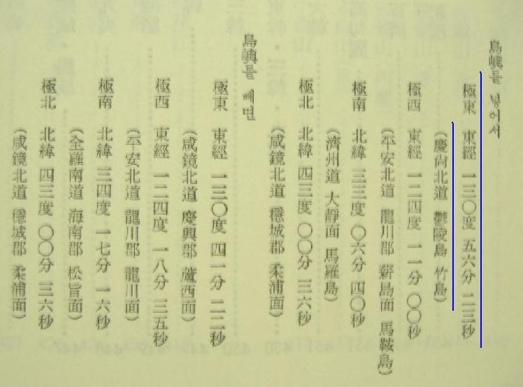