Below are two photos. One is a photo of a stone craved with an old inscription commemorating the 1711 inspection of Ulleungdo by Samcheok Commander Bak Chang-seok (朴昌錫). The other photo shows what could be considered a rubbing of the inscription. (Click on the photos to enlarge.)


The inscription reads as follows:

The inscription reads as follows:
辛卯五月初九日到泊于
倭舡倉以爲日後憑考次
萬里凔溟外將軍駕彩舟
平生仗忠信履險自無憂
搜討官折衡將軍三陟營將
兼僉節制使朴錫昌拙句刻
石于卯方軍官折衝朴省三
折衝金壽元
倭學閑良朴命逸
軍官閑良金元聲
都沙工崔紛
江陵通引金(燮?)
營吏金(?)興
軍色金孝良
中房朴一貫
及唱金時云
庫直金危玄
食母金世長
奴子金禮發
使令金乙奉
I did not translate it because I am not good or confident enough, but it just seems to be saying when and where they craved the stone, and then gives the names and titles of those people in their survey group. I found the photos on the Takeshima Research Center site HERE, so the site may have a translation somewhere.
Bak Chang-seok is an important figure in the Takeshima/Dokdo debate because the map he made of Ulleungdo during his 1711 inspection shows Usando as Ulleungdo's neighboring island of Jukdo. Though many other Korean maps have also shown Usando to be almost certainly Ulleungdo's neighboring island of Jukdo, Koreans have often claimed that the Usando on the maps was just "Dokdo" (Liancourt Rocks) drawn near Ulleungdo for convenience sake. In fact, that is what Steve Barber (Toadface) used to say, though he has not said it recently. :) What makes Bak's map different is that it not only labeled the island as "the so-called Usando" (所謂于山島), but it also labeled it with the words "field(s) of haejang bamboo" (海長竹田). Haejang bamboo is a particular kind of bamboo that can grow up to seven meters tall, which means that Koreans cannot claim, with a straight face, that the Usando on this map was "Dokdo" (Liancourt Rocks) since Dokdo is just barren rocks without the soil needed to grow bamboo.Fortunately, Koreans, including the Director of the Dokdo Museum, have recently started to admit that the Usando on this map and others was Ulleungdo's neighboring island of Jukdo. Instead, they now claim that the maps were drawn in error and people should focus instead on the the words of former boat oarsman An Yong-bok, who said that Japan's Matsushima was Usando. In other words, Koreans want you to ignore the maps drawn by their Ulleungdo inspectors, who were high-ranking officials, and focus, instead, only on the words of a man who was an admitted liar and criminal, which does not seem to bother many Koreans. They also do not seem to be bothered by the fact that An Yong-bok said that Matsushima (Liancourt Rocks) was farther from Ulleungdo than the Korean coast, which is not true, and that Matsushima was much bigger than Ulleungdo, which is also not true. In fact, there are many things in An Yong-bok's testimony that do not add up, but that does not seem to bother Koreans because An Yong-bok is their last great hope, considering that they have no maps and little or no documents to support their claim for "Liancourt Rocks."
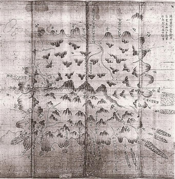
The following is the 1711 map drawn by Pak Chang-seok during his inspection of Ulleungdo. I have also posted a cutout of the Usando portion of the map. By the way, notice the three prominent peaks in the center of the map, which is a clue that another name for this island was "Sambongdo" (Three Peak Island). Koreans claim that "Sambongdo" was another name for "Dokdo," even though there are no maps or documents to support that claim. There are documents, however, that tell us that "Sambongdo" was another name for Ulleungdo.
辛卯五月(初九)日到泊于
ReplyDelete倭舡倉以爲日後港(憑?)考次
萬里滄溟外將軍(駕)彩舟
平生(杖)忠信履險自無(憂)
搜討官折衡將軍三陟營將
兼僉節制使朴錫昌(拙)句刻
石手卯方軍官折衝朴省三
折衝金壽元
倭學閑良朴命遂
軍官閑良金元(聲?)[声殳耳]
This is what I could read. I am not sure they are correct or not, honestly, since they are not clear.
What do you think, pacifist?
Thank you, Kaneganese. Anyway, I think it is just listing the names and titles of the people who went on the trip, including the name of the person who carved the stone.
ReplyDeleteOne thing the stone does do is prove that Bak Chang-seok was on Ulleungdo, so the map he made was made from first-hand observations
Kaneganese,
ReplyDeleteYes, I agree that it is difficult to understand the whole meaning but I think the statement doesn't have grave meaning. It is a record of the party - when they arrived, what did they do, who were the party etc.
BTW, I'm interested in 倭学, is this a subject to learn about Japan?
And I wonder whether did the word 刻石立標 (carved stone standing sign) in the map indicate this stone or not, ...what do you think?
pacifist wrote,
ReplyDelete"And I wonder whether did the word 刻石立標 (carved stone standing sign) in the map indicate this stone or not, ...what do you think?"
That was exactly what I was thinking.
Gerry and pacifist,
I've just finished reading the report by Takeshima Research Centre
They basically explains what is written on the 1711 map, which is similar to what was written on . The only part mentioned about this stone monument script is,
"下條座長のご教示によれば、この絵図の作成年代は、絵図を作成した朴昌錫は「辛卯五月初九日、倭舡倉に到り、泊す」とする石碑を鬱陵島に残しており、その石碑の「辛亥」は、韓国・国立博物館が1963年に刊行した古蹟調査報告書で1711年としている事から、『鬱陵島図形』の「辛亥」は1711年であるとされる。"
"According to Prof.Shimojou, as for the year of this map, the mapmaker Park left stone monument which says 「9th of May in 辛亥, we arrived at 倭舡倉(Japanese Boat Station) and spent night...」. And it says the year was 1711 in the 1963 Korean book of 古蹟調査報告書 by National Museum of Korea. Thus this 辛亥 in 『鬱陵島図形』 should be 1711."
( The final report by Takeshima Research Centre (4)絵図・地図から見た竹島問題 1.韓国側作製の絵図の分析)
I agree that this sentence itself has not such a big meaning, but I also think the most important thing in this inscription is, that it perfectly matches with what was written on the map 『鬱陵島図形』 by Park as pacifist pointed out. As you can clearly see on the last picture, the sentence was written as "刻石立標 (所?) 舡泊所 倭舡倉 民人可居所" in front of Usando(Jukdo). It suggest that Commander Park actually reached today's 臥達里, stayed and saw the island(Usando/Jukdo) in front of the place and reported there were lots of bamboos on the island and he knew it is called Usando.
The report by 張漢相 in 1694 (but rewritten in 壬寅 or 1722 ) also states that there were island with full of bamboos 5-ri (2 km) east to Ulleundo other than one island which is one third as big as Ulleundo and locates 120km to the eastern east-south.
So, we can clearly see that even after Ahn' inconsistant testimony in 1696, Choson official commander Park and Jang clearly knew that "Usando" was not today's Takeshima/Liancourt Rocks, but Jukdo and left those map(辛亥:1711) and document(壬寅:1722 or later) as a official reports.
Correction
ReplyDeleteThey basically explains what is written on the 1711 map, which is similar to what was written on .
→
They basically explains what is written on the 1711 map, which is similar to what was written in the stone inscription by Park.
pacifist wrote;
ReplyDelete"BTW, I'm interested in 倭学, is this a subject to learn about Japan?"
I think it means Japanese translater. It sounds very interesting.
"朝鮮司訳院の日本語教学について
司訳院とは、朝鮮王朝時代に翻訳官を養成するために政府が設立した翻訳学校である。そこには、漢学、蒙学、倭学、女真学などの四つの部門があって、それぞれ漢語、蒙古語、日本語、女真語を教えていた。1393年に初めて司訳院を設立した際には漢学のみであったが、1394年に蒙学を、1414年に倭学を、1426年に女真学を増設した。
本論では、倭学における教育制度・内容や、学生たちの出仕のルートなどに関して考察を行なう。司訳院の倭学では、日本語の教師の定員は二人で、品階は正九品であった。学生の定員は四学の合計が八十人、そのうち倭学の学生は十五人と定められていた。しかし、実際に倭学に入学した学生の人数は、十五人に満たない場合が多かった。
彼らが司訳院で使っていた教科書には、朝鮮王朝の初期・中期・後期で変化があった。初期には『伊路波』など十四冊を用い、中後期には『捷解新語』・『倭語類解』などの本を使うようになった。司訳院の学生たちは会話の練習をする以外に、日本の和歌や俳句などを学ぶこともあった。彼らはその後翻訳科目の試験を受け、その成績いかんによって訳官になった。試験の合格者は成績順で一等、二等、三等にわけられ、それぞれ従七品から従九品の品階を与えられた。(烏雲高娃)" (from the site of Japan Foundation)
Kaneganese & Pacifist,
ReplyDeleteThis is what was written in the back of the book the map was in:
<辛卯五月十四日自倭舡倉移舟待風所拙書 一句以標日後(刻立卯岩木於方上)萬里滄溟外將軍駕桂舟平生伏忠信履險自無漫搜討官折衡將軍三陟營將兼水軍僉節制使朴昌錫軍官折衡朴省三金壽元倭學朴命逸
I think it is saying that when they arrived on the 14th, they found a marker with the strange inscription, "Japanese Boat Storage Area: for storing boats to wait out storms" (自倭舡倉移舟待風所拙書 一句以標). Then, I think it says "the next day we carved on a "standing rabbit rock, just above a tree" (日後(刻立卯岩木於方上):
萬里滄溟外將軍駕桂舟平生伏忠信履險自無漫搜討官折衡將軍三陟營將兼水軍僉節制使朴昌錫軍官折衡朴省三金壽元倭學朴命逸....
I think the above is saying that they carried about an inspection under the orders of "Admiral 駕桂舟" (萬里滄溟外將軍駕桂舟).
Actually, 駕桂舟 does not sound like a name, but I do not know what it means. Maybe it is talking about a kind of boat?
Also, I do not know what a "standing rabbit rock" is, but I am guess it was a rock that looked like a standing rabbit. Of course, I may have misinterpreted. If I did, let me know. At any rate, it looks like they found a marker and decided to carve one of their own.
By the way, here is what is written on the back of the map:
營將朴昌錫所作 鬱陵島地圖
Ulleundgo Map Made by Commander Bak Chang-seok
That means the map was drawn directly by Commander Bak, and not some unnamed mapmaker back home, which gives this map even more credibility.
Kaneganese,
Yes, the 倭学閑良 reference was referring to an "unemployed" Japanese translator.
"刻立卯岩木於方上" "(拙)句刻石手卯方軍官折衝朴省三"
ReplyDelete卯 has several meanings like , direction(East), time(6 o'clock am), rabbit, same as "茂"or "冒". I guess the sentence means that "We carved (the inscription) on one of the many standing rocks on the upper side." or "We carved (the inscription) on a Eastern rock."
The sentence from the map "(拙)句刻石手卯方軍官折衝朴省三"gives us an another clue to understand the "卯", "They carved on the stone on the east." or "They carved on the stone. Eastern commander 朴省三 ..."
"駕桂舟"or "駕彩舟" means ride on the "桂"(Katsura tree, a name of the tree) or colourful boat.
So, the group arrived at "倭舡倉" in front of Jukdo on 9th of May and used it as a harbour. Maybe they inspected on the Eastern side of Ulleundo including Jukdo or at least they checked the distance and appearance of Jukdo and recorded as "所謂于山島 海長竹田". Then, when they left there to "待風所" on 14 th of May, they carved inscription on the rock to commemorate their achievement that they came over a great distance (萬里滄溟外) of the sea all the way from mainland to inspect this island.
Thank you, Kaneganese.
ReplyDeleteYes, the "east standing rock" (立卯岩) makes much more sense.
As for 駕桂舟, I did not realize 駕 meant "to ride" until I rechecked the character in my dictionary. Of course, the 馬 part of the character should have given me a clue. Yes, it does seem to be saying "they rode a 桂舟 (cinnamon tree boat), which appears to have been a specific kind of boat. I have seen the 桂舟combination in other documents, but I have not seen a description.
As you can see, my Chinese reading ability is very basic.
Hi, everybody.
ReplyDeleteWhat I can read in that inscription is this :
辛卯五月初九日到泊于
倭舡倉以爲日後憑考次
萬里凔溟外將軍駕彩舟
平生仗忠信履險自無憂
搜討官折衡將軍三陟營將
兼僉節制使朴錫昌拙句刻
石于卯方軍官折衝朴省三
折衝金壽元
倭學閑良朴命逸
軍官閑良金元聲
都沙工崔紛
江陵通引金(燮?)
營吏金(?)興
軍色金孝良
中房朴一貫
及唱金時云
庫直金危玄
食母金世長
奴子金禮發
使令金乙奉
Good night.
Thank you, MyCoree. I added your transcription to the post.
ReplyDeleteDokdo is land of Korea.
ReplyDeleteI cannot understand why Japanese are keep arguing that Dokdo is theirs... are they stupid or something?
In Dokdo, there is no Japanese...
only Korean live there. Even Japanese keep say that Dokdo is theirs, it cannot change...
dear anonymous,
ReplyDeleteI understand that you believe that Dokdo belongs to your country, but please think it over again, it was owned by Japan since the 17th century.
Your government has educated Korean people that Korea owned it since the ancient times, but it was not true. If you feel doubtful, please read the various postings in this site.
The truth is that President 李承晩 (Rhee Syngmann), the dictator, robbed it from Japan in 1952.
The name Dokdo is very new one, it was named in early 1900's. Until then there was no Korean name for it.
But anyway, I'm thankful for you for saying your opinion.
Please read the various postings and give us your opinion again.