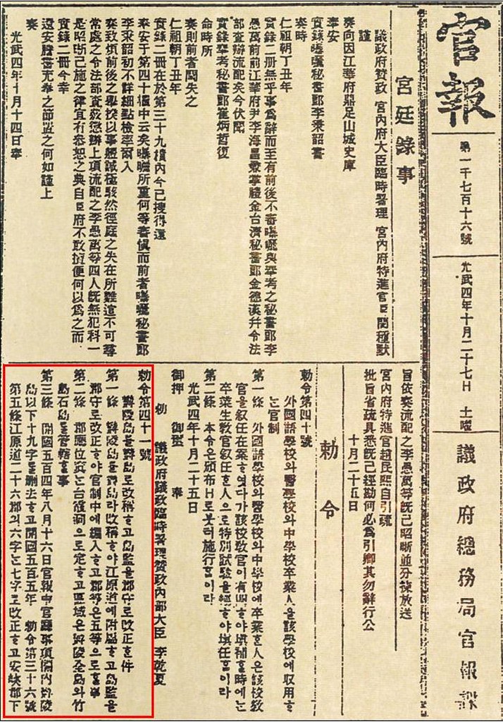
 On October 25, 1900, Korea's highest government agency, the Uijeongbu (議政府), submitted for Korean Emperor Kojong's approval Imperial Edict No. 41, which would make the Korean island of Ulleungdo a county of Gangwon Province (江原道). The Korean emperor stamped his seal to the edict, and on October 27, the edict was announced in the Gwanbo (官報), the official newsletter of the Korean government. The relevant page of the October 27 newsletter is pictured on the left with the annoucement of Imperial Edict No. 41 (勅令第四十一號) outlined in red.
The edict changed the name of Ulleungdo (鬱陵島) to "Uldo" (鬱島) and made it a county of Gangwon Province (江原道). It also established the office of "County Magistrate" (郡守), who would be considered a "level 5" official in Korea's civil service system. The office of the county magistrate would be located on the island in the village of Taehadong (台霞洞), and the magistrate would have jurisdication over the whole island of Ulleungdo (鬱陵全島), Jukdo (竹島), and the "rock islets" (石島). The following is a translation of the first two articles of Imperial Edict No. 41:
Imperial Edict No. 41Koreans claims that the "seokdo" (石島) in the edict was a reference to Liancourt Rocks, which Koreans call "Dokdo" (獨島); however, Korea has no maps or documents to back up that claim. In fact, since there are no Korean maps showing Liancourt Rocks, it is very likely that Korean officials did not even know about Liancourt Rocks in 1900.
Renaming Ulleungdo as Uldo and Changing the Island's Administrator to County Magistrate
ARTICLE 1: Ulleungdo is renamed "Uldo" (鬱島) and is made a part of Gangwon Province (江原道). Island Administrator is changed to "County Magistrate" (郡守) and becomes a "level 5" (五等) offical in the civil service system (官制).
ARTICLE 2: The county office will be located at Taehadong (太霞洞), and will have jurisdiction over the whole island of Ulleungdo (鬱陵全島), Jukdo (竹島), and the rock islets (石島).
 A September 3, 1899 article (pictured on the left) in the Korean newspaper Hwangseong Sinmun (皇城新聞) described Ulleungdo as follows:
In the sea east of Uljin is an island named Ulleung. Of its six, small neighboring islands, Usando/Jukdo (于山島竹島) is the most prominent (崔著者). The Daehanjiji (大韓地誌) says that Ulleungdo is the old Country of Usan. It has an area of 100 ri. Three peaks stand out (律兀). Its products are siho (柴胡 - a variety of dropwort), gobon (藁本 - another variety of dropwort), seoknam (石楠 - kind of camphor), juniper (香木), zelkova (槻木), and nojuk (蘆竹 - a reed-like bamboo). The land is suitable for growing barley (宜麥). In the past, “water animals” (水獸) that looked like “cows without horns” (牛形無角) lived there and were called “gaji” (可之). There are also seabirds called "gwakjo" (霍鳥).Notice in the above article that Ulleungdo was described as having six, small neighboring islands, of which "Usando/Jukdo" (于山島竹島) was the most prominent. It is not known for sure how the reporter came to know that Ulleungdo had six neighboring islands, but since most Korean maps of Ulleungdo did show it with six neighboring islands, it is very likely that the reporter got his information from these maps. In fact, he even mentioned the Daehanjiji, which was a geography textbook that included a map very similar to the following 1898 map of Ulleungdo:
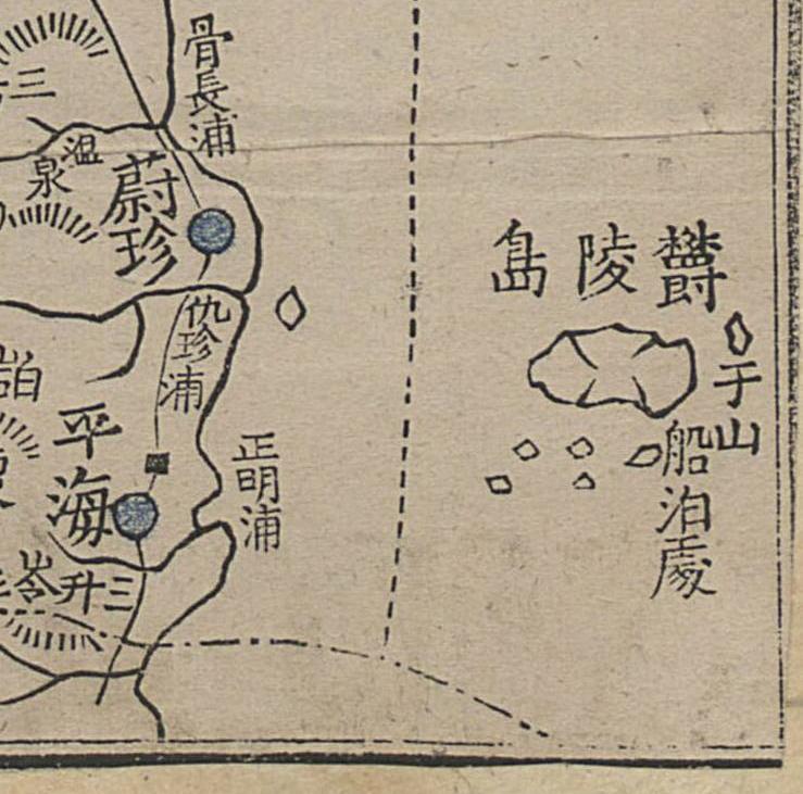
Notice that the map shows Ulleungdo (鬱陵島) with a small island off the east shore labeled as "于山" (Usan). It also shows five other islands off the southern shore of Ulleungdo, which were almost certainly a mapping error since most of Ulleungdo's "rock islets" (石島) are off Ulleungdo's northern shore. At any rate, the above map and many others show Ulleungdo having six, small neighboring islands with "Usan" island (于山島) being the most prominent. Usando was almost certainly an old name for Ulleungdo's neighboring island of Jukdo (竹島), which is about 2.2 kilometers off Ulleungdo's east shore. The 1899 newspaper article most likely used the phase "Usando/Jukdo" (于山島竹島) to show that two names were used to refer to the same island.
The 1899 newspaper article also talked about sea animals (水獸) that looked like "cows without horns" (牛形無角) and were called "gaji" (可之), which was a Korean name for "sea lion." The article said that sea lions "used to" (古에) live on Ulleungdo, which means they were no longer living on Ulleungdo at the time. That fact would eliminate the possibility that one of the neighboring islands referred to in the article was Liancourt Rocks (Dokdo / Takeshima) since sea lions were still living and breeding on Liancourt Rocks at the time.
The 1900 imperial edict mentioned Ulleungdo, Jukdo, and "seokdo" (石島), but it did not mention "Usando" (于山島), even though "Usando/Jukdo" was mentioned as Ulleungdo's most prominent neighboring island in the 1899 Hwangseong Sinmun article. This is more evidence that Usando was just an alternate name for Jukdo. The Korean government obviously decided to make "Jukdo" the official name of Ulleungdo's neighboring island, even though "Usando" was written before "Jukdo" in the 1899 article, and even though most of Korea's old maps used the name "Usando" instead of "Jukdo."
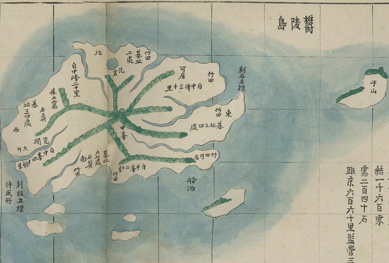
For example, consider the following Korean map of Ulleungdo, which was made sometime between 1884 and 1894. That means it was made after Koreans starting living on Ulleungdo. The map still showed an island off the east shore of Ulleungdo labeled as "Usan" (于山 - 우산) in a position that could only have been Ulleungdo's neighboring island of Jukdo (竹島 - 죽도). It even has a similar shape to Jukdo. Notice that the map also has the same five neighboring islands to the south.
As mentioned above, the Korean government claims that the "seokdo" (石島) mentioned in the 1900 imperial edict was a reference to Liancourt Rocks (Dokdo), but Korean officials do not have any maps or documents to back up that claim. Instead, they give an elaborate linguistic explanation of how the name "seokdo" (石島) evolved into "Dokdo" (獨島). However, since there are no maps that show Ulleungdo with an island named "Seokdo" (石島) and since the name was never mentioned again in any document referring to Uleungdo, the most likely explanation for "seokdo" (石島) is that it was a legal catchall phrase used to include Ulleungdo, Jukdo, and all the other "rock islets" (石島) around Ulleungdo under the jurisdiction of the Uldo (鬱島) County magistrate. That means that the other five neighboring islands mentioned in the 1899 Hwangseong Sinmun article would have been covered by the word "seokdo" (石島).
The following is a cutout from an old Korean map of Korea's Pyeongan Province (平安道), made sometime after 1776, that shows a small group of rocks in the sea labeled as 石島, which means "rock islets." This map is proof that the name "seokdo" (石島) was also used as a descriptive word to refer to "rock islets."

Gerry,
ReplyDeleteThis is really great! It's logical and persuasive with evidences to supprot. And “石島” in 1776 map you cited was a good example that Korean did called and wrote rocky islets as "石島" just like this edict. Looks like Korean wrote "石島" in both way. Rocky island which hanmaumy showed us before and rocky islets or rocks.
Beautiful.
ReplyDeleteThe riddle solved.
Gerry,
ReplyDeleteCongrats! You won!
Awesome Observations!
ReplyDeleteAnd that is the reason why in 1906,Ulleungdo's Officer hadn't protested Japanese about Liancourt Rocks with saying the ground of Seokdo石島 in the Imperial Edict of 41 year 1900.
1. 于山島竹島
ReplyDelete于山島 = 竹島 ? (x)
于山島 and 竹島 (o - 2 islands)
called as "Usan-island-Juk-island" ?
that's very insane name.
"Usan-island" and "Juk-island"
just two islands. ok?
you been incorrect very first start. try again.
in 1906, Ulleungdo's Officer hadn't protested??
ReplyDelete<<<
1905~1945, korea was deprived of their diplomatic authority by japan.
Ministry building was japanese made, minister was all japanese.
how can they protest to japan?
in 1906, korea can't country:country talk.
so, in 1906, Ulleungdo's Officer can't protested to japan.
and you think that map is 100% "precision" and correct map?
ReplyDeleteas you see, that map written poorly and very rough. just see sea-shore line. you think that that map is "very precision" map?
Ullung's east side have usan-island. that's the meaning of this map.
in this map, where is the jukdo?
where is the gwanumdo? huh?
why you compare by this poor map?
also, do you know other 5 island name? you still don't know.
also, why you think
ReplyDelete1776 map's 石島 is 100% same with 1990 edict's 石島?
1776 map is NOT equal with 1900 edict.
石島 name means "stone island" or "rocky island" or "rock islets".
Hwanseong's 石島.
Ulleungdo's 石島.
all possible.
why you think 石島 name must use tiny islets?
your claim no basis.
and do you have any source of south rock name was 石島? no.
Anonymous,
ReplyDeleteGerry showed an example that the word 石島 was used as "rock islets" (plural rock islets) and also showed that the word can be used as a common noun, not a proper noun.
And it has been shown that around the year 1900, Korean maps of Ulleungdo showed Uleungdo and its neighboring island of Jukdo and five other rock islets.
And it has been also shown that Korean empire (1895~1910) recognised its eastern boundary as Ulleungdo and Jukdo, not Liancourt rocks. (British journals and Japanese journals also excluded Liancourt rocks from Korean territory.)
So it is natural to think that the 1900 ordinance may have directed that Ulleungdo, Jukdo and other rock islets as Gerry wrote.
Anonymous, in 1905-1906 Korea was an independent country. It was 1910 when Korea was annexed.
After the China-Japanese war, Russia had increased its power in Korea and the influence of Japan was decreased at the time. Actually Korea claimed the UK-Japan alliance.
And when the information about Liancourt rocks went to the central government, they ordered the investigation about the shape of the island etc. It shows that they didn't know about the island. And after the investigation, they didn't do anything. They came to know the truth - the neighboring country incorporated two rocks that Korea never had owned.
Gerry showed an example that the word 石島 was used as "rock islets" (plural rock islets) and also showed that the word can be used as a common noun, not a proper noun.
ReplyDelete>>>> korea never called south ulleung rocks as "island".
also, they never called as 石島.
And it has been shown that around the year 1900, Korean maps of Ulleungdo showed Uleungdo and its neighboring island of Jukdo and five other rock islets.
>>> i already tell this,
this guy confused "word".
why this guy think 于山島竹島 is one island?
于山島 = 竹島 (X)
于山島 + 竹島 (O)
it means 于山島 and 竹島. 2 islands.
this guy confused with this.
And it has been also shown that Korean empire (1895~1910) recognised its eastern boundary as Ulleungdo and Jukdo, not Liancourt rocks.
>>>>>>> just read carefully that news, 1. you think news paper is official goverment statement? what a nonsense.
2. already said, 于山島竹島 mean 于山島 + 竹島 (O). two islands.
why this word interpret as same island? i just curious.
(British journals and Japanese journals also excluded Liancourt rocks from Korean territory.)
>>>>>> many russia and japan map and goverment document excluded Liancourt rocks from Japan territory.
So it is natural to think that the 1900 ordinance may have directed that Ulleungdo, Jukdo and other rock islets as Gerry wrote.
>>>>> according to Edict No. 41, Jukdo already included. you confuse this?
Anonymous, in 1905-1906 Korea was an independent country. It was 1910 when Korea was annexed.
>>>>> korea was independence country? are you retarded?
in 1905, korea deprivation of diplomatic rights by japan.
and 5 years after, they annexed with japan.
after 1905, korea diplomatic minister are all japanese.
And when the information about Liancourt rocks went to the central government, they ordered the investigation about the shape of the island etc. It shows that they didn't know about the island.
>>>>> they didn't know about the island? are you retarded? korea inhabit ulleung do since 512. dokdo visible in ulleung island.
they can visible dokdo island but they did not knew dokdo existence? what a nonsense.
"visible dokdo island in ulleungdo" this proved by 1903 japanese record, too.
And after the investigation, they didn't do anything.
>>> are you retarded? they fished that island. and goverment officer adminstrative this island.
They came to know the truth - the neighboring country incorporated two rocks that Korea never had owned.
>>> in japan territory, they can not see dokdo island.
but korean side can.
this prove that 'korean did not know dokdo's existence' is lie.
korean residence ulleungdo for 1700 years. almost 1700 years, they never know visible island?
THIS ISLAND VISIBLE IN ULLEUNGDO, BUT KOREAN NEVER KNOW ISLAND EXISTENCE during 1700 years? what a nonsense.
you think that your claim is normal?
also, so many historical record proved that korean act in this island and use this island.
Gerry write about Hwangseong Sinmun article in 1899. and he said, even Hwangseong Sinmun never know liancourt rocks existence.
ReplyDeletebut,
According to Hwangseong Sinmun (皇城新聞) 1906.5.9 news,
Hwangseong Sinmun protest incorporate dokdo belong to japan.
on the contrary, this is good evedience of dokdo belong to korea.
Dear anonymous,
ReplyDeleteI will answer to your questions one by one.
1)">>>> korea never called south ulleung rocks as "island".
also, they never called as 石島".
Yes, that's right. They never called islets around Ullengdo Seokdo (and also they never called Liancourt rocks as Seokdo), because as Gerry proved Seokdo was a common noun, not a proper noun like Ulleungdo, Jukdo etc.
So the Seokdo that the local governemnt wrote may have meant plural rock islets around Ulleungdo.
2) ">>> i already tell this,
this guy confused "word".
why this guy think 于山島竹島 is one island?"
This is because there are many examples in Korean old documents to write two names in sucession to show one island with two names.
3)">>>>>> many russia and japan map and goverment document excluded Liancourt rocks from Japan territory."
No, please read the following documents and maps.
http://dokdo-or-takeshima.blogspot.com/2007/06/1870-report-how-tamkshima-matsushima.html
http://dokdo-or-takeshima.blogspot.com/2007/06/1876-argument-about-development-work-of.html
http://dokdo-or-takeshima.blogspot.com/2007/05/japanese-document-and-map-links.html
The Meiji governemnt was once in turmoil and couldn't know about Takeshima and Matsushima, but they investigated the area by warship Akagi and found the truth.
4) ">>>>> according to Edict No. 41, Jukdo already included. you confuse this?"
欝陵島全島 = The whole Ulleungdo,
竹島 = Jukdo
石島 (Seokdo) = plural rock islands
Do you understand?
5) ">>>>> korea was independence country? are you retarded?"
No, I'm not retarded. Korean empire was an independent country, the first independent Korea after being a tributary to Ming and Qing for 500 years. Although unfortunaletly you were made to believe that Japan deprived of all the government function before the annexation, it was not true. Korea was not totally controlled by Japan.
If Japan really totally controlled Korean empire, how they could order the investigation about the shape of the island Japan incorporated, or about what Japanese officials did in Ullengdo?
And if Korea was under control of Japan, why Japan had to annex Korea in 1910?
6) ">>>>> they didn't know about the island? are you retarded? korea inhabit ulleung do since 512".
anonymous, we are talking about Liancourt rocks (Takeshima/Dokdo), not Ulleungdo.
As we have already shown, Usando was not Liancourt rocks, Sambongdo was not Liancourt rocks and Seokdo was not Liancourt rocks. And the name Dokdo is a new name, whcih was made in the 1900's.
Korean people didn't know about Liancourt rocks until 1900's. There is only one depiction about it in the 17th century, but it says that they only saw it from Ullengdo and it was no name and they hadn't exact information about it.
7) "visible dokdo island in ulleungdo" this proved by 1903 japanese record, too".
Please read the following. It's not a proof of the ownership of Liancourt rocks. (Sorry, it's in Japanese)
http://dokdo-or-takeshima.blogspot.com/2007/06/361903liancourt-rocks-liancourt-rocks.html
8) ">>> are you retarded? they fished that island. and goverment officer adminstrative this island."
No, I'm not retarded, but I can't understand what you say. Korean officials ordered the investigation but after that they didn't claim. Because they came to know that it was their island.
9)"korean residence ulleungdo for 1700 years. almost 1700 years, they never know visible island?"
The island had been empty for hundreds of years and there were people now and then but not continuously.
10) "Hwangseong Sinmun protest incorporate dokdo belong to japan."
Have you read the newspaper article? It says Japanese officials asked about population and amount of total products in Dokdo. But as you may notice, it was misunderstnading. Japanese officials asked the chief of the Ullengdo about the population and the amount of products as a greeting. It was transmitted to the local government and the misunderstanding occured.
But think it over again. If they truly knew about Liancourt rocks, such a misunderstanding had never occured because, as you know, Liancourt rocks (Takeshima/Dokdo) had no population, no products.
And anonymous, the newspaper article is not a protest, it was a news, and the news was misunderstood one. How do you say this was a protest?
Sorry, correction:
ReplyDelete"Because they came to know that it was their island". (in the item 8)
SHOULD BE ....that it was not their island.
It is because Why 于山島竹島 is one island, no two islands is;
ReplyDeleteCheck the text of 皇城新聞 1899.
1.皇城新聞 said Usando is MOST最 prominent著者 of small six adjunctive islets.
MOST Prominent= One.
cf:鬱陵X其附属一小六島中X最著者X干山島竹島XX.
In addition, most of all the Korean map with detail of Ulllungdo, there is small six adjunctive rocks includes Usando.But there are only one island attached the name-only Usan/Usando name. Other 5 rocks have no name. It shows Usando is only one most prominent adjunctive island within 6 small adjunctive rocks.
2.皇城新聞 wrote that 于山島竹島 without "Comma".
They introduced Ulleungdo's local products with using comma because there are multiple local products.
cf.律XXX所産X柴故、藁本、石楠、藍竹XXX、
3.The name of Jukdo replaces from name of Usando,after the Lee's inspection of 1882,even though uUsando had commonly been used in the map.
cf.鬱陵島外図.
Those historical maps show clealy tell that.
FIRST OF ALL, SORRY MY POOR ENGLISH.
ReplyDeletePlease understand my poor english skill.
I will answer to your questions one by one.
So the Seokdo that the local governemnt wrote may have meant plural rock islets around Ulleungdo.
>>> 石島 mean Stone island, Rocky island, Rocky islets. but why do you think 石島 "must" described as "plural rock"?
huh?
Like already mentioned,
Pyeongan's 石島 (near Pyeongan's Rocky island)
Ulleung's 石島 (near Ulleung's Rocky island)
all possible.
This is because there are many examples in Korean old documents to write two names in sucession to show one island with two names.
>>> i already tell this,
this guy confused "word".
why this guy think 于山島竹島 is one island?
于山島 = 竹島 (X)
于山島 + 竹島 (O)
it means 于山島 and 竹島. 2 islands.
this guy confused with this.
many russia and japan map and goverment document excluded Liancourt rocks from Japan territory."
>>> oh, you did not know? i do not want explain to you. i'm busy man. find yourself.
The Meiji governemnt was once in turmoil and couldn't know about Takeshima and Matsushima, but they investigated the area by warship Akagi and found the truth.
>>> The meiji Govemrnet "officialy" excluded Liancourt rocks from Japan territory.
http://www.geocities.com/mlovmo/temp24.html
欝陵島全島 = The whole Ulleungdo,
竹島 = Jukdo
石島 (Seokdo) = plural rock islands
>>> 石島 mean Stone island, Rocky island, Rocky islets. but why do you think 石島 "must" described as "plural rock"?
huh?
Like already mentioned,
Pyeongan's 石島 (near Pyeongan's Rocky island)
Ulleung's 石島 (near Ulleung's Rocky island)
all possible.
Do you understand?
Korea was not totally controlled by Japan.
>> like already metioned,
in 1905, Korea deprivation of diplomatic rights by japan.
and 5 years after, they annexed with japan.
after 1905, korea diplomatic minister were all japanese.
i do not explain to you, twice. just find yourself.
乙巳條約
1. 日本國政府ハ在東京外務省ニ由リ今後韓國ノ外國ニ對スル關係及事務ヲ監理指揮スへク日本國ノ外交代表者及領事ハ外國ニ於ケル韓國ノ臣民及利益ヲ保護スへシ
2. 日本國政府ハ韓國ト他國トノ間ニ現存スル條約ノ實行ヲ全フスルノ任ニ當リ韓國政府ハ今後日本國政府ノ仲介ニ由ラスシテ國際的性質ヲ有スル何等ノ條約若ハ約束ヲナササルコトヲ約ス
Korea deprivation of diplomatic rights by japan.
They couldn't protest by country:country talk.
also, check "Hague Secret Emissary Affair"(1907)?
http://www.seoulselection.com/events_read.html?cid=3939
As we have already shown, Usando was not Liancourt rocks
>>> it's just baseless japanese claim.
Sambongdo was not Liancourt rocks and Seokdo was not Liancourt rocks.
>>> it's just baseless japanese claim.
And the name Dokdo is a new name, whcih was made in the 1900's.
>>> then, what do you think takeshima(Bamboo island) name?
the name Takeshima is a new name by japan, whcih was made in the 1905's.
in old times, Japanese call ulleungdo was takeshima.
but, 1905, they called Lian court rocks as takeshima???????
Korean people didn't know about Liancourt rocks until 1900's.
>>> like already metioned, this is just stupid japanese claim.
many historical record prove it. (just find yourself)
they didn't know about the island? are you retarded? korea inhabit ulleung do almost 2000 years. dokdo visible in ulleung island.
they can visible dokdo island but they did not knew dokdo existence? what a nonsense.
"visible dokdo island in ulleungdo" this proved by 1903 japanese record, too.
There is only one depiction about it in the 17th century, but it says that they only saw it from Ullengdo and it was no name and they hadn't exact information about it.
>>> japanese called liancourt rocks as 松島. but, in 1905 japanese made 'new' name. totally irrelevant name in historically.
"visible dokdo island in ulleungdo" this proved by 1903 japanese record, too".
Please read the following.
http://www.dokdo-takeshima.com/dokdo-visual.html
you said, korean people never know liancourt rock existence during 2000 years?
in ulleungdo liancourt rocks is visible island. but they never know existence of island?
korean side can view liancourt rocks. japanese side can not view liancourt rocks.
you japanese claim that "KOREAN NEVER KNOW EXISTENCE OF ISLAND! EVEN CAN SEE IN THEIR TERRITORY!"
that's very insane logic.
No, I'm not retarded, but I can't understand what you say. Korean officials ordered the investigation but after that they didn't claim. Because they came to know that it was their island.
">>> i do not say twice. you just troll without fact. many hitoric record and official govoemrent record said korea have fishery rights in that island.
and goverment officer adminstrative this island.
The island had been empty for hundreds of years and there were people now and then but not continuously.
>>> yeah, that island empty to japanese. the island use as fishery in korea control.
Have you read the newspaper article? It says Japanese officials asked about population and amount of total products in Dokdo
And anonymous, the newspaper article is not a protest, it was a news, and the news was misunderstood one. How do you say this was a protest?
>>> did you read Hwangseong Sinmun (皇城新聞) carefully?
"本部所屬 獨島가"
"本部所屬 獨島가"
"本部所屬 獨島가"
"本部所屬 獨島가"
It was transmitted to the local government and the misunderstanding occured.
But think it over again. If they truly knew about Liancourt rocks, such a misunderstanding had never occured because, as you know, Liancourt rocks (Takeshima/Dokdo) had no population, no products.
>>> huh? you made "new" situation? in that time, who korean said like that? huh?
1. The Japan Govemrnet "officialy" excluded Liancourt rocks from Japan territory. and declared korea's territory.
2. korean goverment officier administration this island. and korean fisher man use this island in korea goverment permission.
3. korean exercised fishery rights.
I DO NOT WANT SINGING TROLL.
SO, IF YOUR ANSWER SAME LIKE THAT, I DO NOT ANSWER TO YOU NO MORE.
I JUST THINK
"A dog can't never stop being a dog."
also, you can't beat it.
i yhink i have no need answer stupid logic.
also, my english skill is poor, i little tired.
whatever you said,
YOUR CLAIM IS.....
1. "have no ground for believing"
2. "can not beat korean claim"
3. "you just attack korean claim by distort the meaning. but also you do not prove that why this island belong to japan"
anonymous,
ReplyDelete1) ">>> 石島 mean Stone island, Rocky island, Rocky islets. but why do you think 石島 "must" described as "plural rock"?
huh?"
anonymous, Gerry pointed out that the word Seokdo can be used as a common noun. Can you understand?
If there is no island called Seokdo around Ulleungdo (and actually there was no island called Seokdo around Ulleungdo as you say), it was not used as a proper noun.
So it is most likely used as a common noun. And if it was used as a common noun, it may have meant the rock islands around Ulleungdo except Jukdo, because many maps around 1900 show that Ulleungdo had 6 islands, Jukdo and five rock islets. It is a logical thinking. Can you understand?
2) ">>> i already tell this,
this guy confused "word".
why this guy think 于山島竹島 is one island?
于山島 = 竹島 (X)
于山島 + 竹島 (O)
it means 于山島 and 竹島. 2 islands.
this guy confused with this".
Can't you understand what I wrote? Should I repeat the same thing again? I wrote that there are many examples in old Korean documents to write two names in succession (just like UsandoJukdo) to show one island with two names. It is not strange to understand this case as the same. Why can you say it was two islands? Your insistency has no ground.
3) ">>> oh, you did not know? i do not want explain to you. i'm busy man. find yourself".
Don't run away, you didn't show your firm evidence of what you mentioned.
4) ">>> The meiji Govemrnet "officialy" excluded Liancourt rocks from Japan territory.
http://www.geocities.com/mlovmo/temp24.html"
anonymous, the site you showed is Pro-Korean Dokdo lobbyist's site. His site and Steve Barber's site are not accurate especially on the Japanese documents.
Please read the following:
http://dokdo-or-takeshima.blogspot.com/2007/06/1870-report-how-tamkshima-matsushima.html
5) >> like already metioned,
in 1905, Korea deprivation of diplomatic rights by japan.
and 5 years after, they annexed with japan.
after 1905, korea diplomatic minister were all japanese.
i do not explain to you, twice. just find yourself.
乙巳條約
1. 日本國政府ハ在東京外務省ニ由リ今後韓國ノ外國ニ對スル關係及事務ヲ監理指揮スへク日本國ノ外交代表者及領事ハ外國ニ於ケル韓國ノ臣民及利益ヲ保護スへシ
2. 日本國政府ハ韓國ト他國トノ間ニ現存スル條約ノ實行ヲ全フスルノ任ニ當リ韓國政府ハ今後日本國政府ノ仲介ニ由ラスシテ國際的性質ヲ有スル何等ノ條約若ハ約束ヲナササルコトヲ約ス
Korea deprivation of diplomatic rights by japan.
They couldn't protest by country:country talk."
Hey can you read the original text above? (Can't you read Japanese/Chinese text?)
It only mentions that Japanese representaives and consuls should protect Korean people and their profits in abroad (item#1) and that Korea should not conclude any treaties with international character without intervention by Japannese governemnt in order to complete the present treaties between Korea and other countries (item #2).
Where did they write that Japan deprived all of the diplomatic rights?
Where did they write that Korea should not claim about territories?
Nothing.
The treaty was done to protect Korea, it was made for Korea.
6) "also, check "Hague Secret Emissary Affair"(1907)?
http://www.seoulselection.com/events_read.html?cid=3939"
Don't you know that the Koreans' claim in Hague was recognised as unfair thing by western countries, it was rejected by international society.
Please look at this Wikipedia (although it was written in Japanese):
http://ja.wikipedia.org/wiki/%E3%83%98%E3%83%BC%E3%82%B0%E5%AF%86%E4%BD%BF%E4%BA%8B%E4%BB%B6
7) "As we have already shown, Usando was not Liancourt rocks
>>> it's just baseless japanese claim."
Please read the various posters in Gerry's site. You will see the truth.
About Usando, please read this:
http://dokdo-or-takeshima.blogspot.com/2007/10/where-have-all-usandos-gone.html
8)"Sambongdo was not Liancourt rocks and Seokdo was not Liancourt rocks.
>>> it's just baseless japanese claim."
You should read Korean old documents by yourself, not relying on Dokdo lobbyists' sites. If you have an ability to read Chinese letters, you will see the truth soon.
9) "And the name Dokdo is a new name, whcih was made in the 1900's.
>>> then, what do you think takeshima(Bamboo island) name?
the name Takeshima is a new name by japan, whcih was made in the 1905's.
in old times, Japanese call ulleungdo was takeshima.
but, 1905, they called Lian court rocks as takeshima???????"
Yes, that's true. Takeshima was a new name for Liancourt rocks named in 1905, but Japanese had old names for Liancourt rocks - Matsushima in the 17th, 18th centuries and Ryanko or Yanko island in the late 19th century. It is a fact that Japan recognised Liancourt rocks and used the rocks for centuries.
But Korea didn't recognise Liancourt rocks until 1900's. There was no Korean name for it until 1900's.
If you refute, please show the evidence to show that Korea knew Liancourt rocks before the 1900's. Historians had failed to find such evidence.
9)"visible dokdo island in ulleungdo" this proved by 1903 japanese record, too".
Please read the following.
http://www.dokdo-takeshima.com/dokdo-visual.html"
Don't believe Steve Barber's site. His site seems to be full of distorted information. Visibility is not equal to ownership, anonymous. If visibility means ownership, Japan may claim for Ulleungdo (visible from Liancourt rocks), and for Busan (visible from Tsushima island). It is meaningless.
And only one record that a Korean saw the island far away from Ullengdo was the only report. they didn' even go to the island, they didn't have exact information (they didn't know that Liancourt rocks comprised of two rock islets), they didn't have a name for the island, according to the record.
10) "you said, korean people never know liancourt rock existence during 2000 years?
in ulleungdo liancourt rocks is visible island. but they never know existence of island?
korean side can view liancourt rocks. japanese side can not view liancourt rocks.
you japanese claim that "KOREAN NEVER KNOW EXISTENCE OF ISLAND! EVEN CAN SEE IN THEIR TERRITORY!"
that's very insane logic".
If you really think so, you should prove it. But there is no evidence to show that Korean came to Liancourt rocks. Koreans didn't have exact maps of Liancourt rocks, while Japanese have various maps of Matsushima (Liancourt rocks) with two rocky islets.
If really Koreans came to Liancourt rocks, they should have noted in some documents and should have made maps. But such an evidence had never ever appeared in history. If you have, you will be a Korean hero.
11)"">>> i do not say twice. you just troll without fact. many hitoric record and official govoemrent record said korea have fishery rights in that island.
and goverment officer adminstrative this island".
Fishery rights? There is no such things. If you think so, please show us the evidence.
12) "The island had been empty for hundreds of years and there were people now and then but not continuously.
>>> yeah, that island empty to japanese. the island use as fishery in korea control".
Do you know about the empty policy of islands? Ulleungdo had been empty for hundreds of years, during the period Japanese went there to fish and hunt sea lions. Murakawa's and Oya's families kept going to Ullengdo every year for about 80 years, during the years Korean people didn't come until 1692 when Murakawa's family saw Koreans catching abalones using Murakawa's fishery gears.
13) "Have you read the newspaper article? It says Japanese officials asked about population and amount of total products in Dokdo
And anonymous, the newspaper article is not a protest, it was a news, and the news was misunderstood one. How do you say this was a protest?
>>> did you read Hwangseong Sinmun (皇城新聞) carefully?
"本部所屬 獨島가"
"本部所屬 獨島가"
"本部所屬 獨島가"
"本部所屬 獨島가""
Of course, I know it. But it was a misunderstanding. At first the chief of Ulleungdo misunderstood that it was one of Korean islands, but it was a false information. He didn't know even the location of the island. The information made the central governemnt order to investigate it but at last they didn't claim for it, because they came to know that it was out of Korean territory.
And such an incorrect newspaper article is not a proof of ownership of Liancourt rocks, anonymous.
All you have to do is to find the evedence that Korea really knew Liancourt rocks and reached them and controlled them. We kept asking Steve Barber to do this but he had not succeeded in it.
14) "It was transmitted to the local government and the misunderstanding occured.
But think it over again. If they truly knew about Liancourt rocks, such a misunderstanding had never occured because, as you know, Liancourt rocks (Takeshima/Dokdo) had no population, no products.
>>> huh? you made "new" situation? in that time, who korean said like that? huh?
I can't understand your opinion above. I only told about the incorrect newspaper article. The article says that Japanese officials asked about the population and amount of products of Dokdo. Can't you understand what I wrote?
15)"1. The Japan Govemrnet "officialy" excluded Liancourt rocks from Japan territory. and declared korea's territory".
Japan had never ever excluded Liancourt rocks.
Please llok at the MOFA site.
Japan had never ever declared it's Korean territory. (Maybe you got such false infromation from Dokdo lobyists' sites but these are groundless claims.)
If you really think so, please show us the evidence.
16) "2. korean goverment officier administration this island. and korean fisher man use this island in korea goverment permission".
Yes, they are occupying Liancourt rocks but it was illegal under the international law. Korean government keeps rejecting to go to international court because they know it is a illegal thing.
Don't you know Japanese fishermen were killed and injured by Korean coast guards or Korean soldiers? I think this fact was not informed to Korean people but Rhee Syngman robbed the island brutally and killed Japanese fishermen. Do you know it?
17) "3. korean exercised fishery rights"."
Many Korean people are not informed but after the negotiation between Japan and Korea, both of Japanese and Korean fishermen can tentatively engage in fishery in the sea around Liancourt rocks. But as a matter of fact, if Japanese fish boats approach it, Korean coastal guard shoot them. So Japanese fishermen can't engage in fishing in the area, that was the reason Shimane prefecture made the day of Takeshima, Takeshima was the fishery area for their fathers, grandfathers and grand-grandfathers but now they can't engage in fishing in the area.
The last thing to tell you; anonymous, in this site, you must not use dirty words such as "stupid", "retarded", "singing troll" etc. Please give me the answer in getleman's manner. If you do so I will keep dabating in gentleman's manner too.
Kaneganese-san
ReplyDelete1750~1768 - Joseon Jido (朝鮮地圖) - Ulleungdo"の私の投稿ですが、自分の文章であるにもかかわらず自分自身わかりにくい文章だったので納得いかず取り急ぎ改めて書き直してみました。
同時に、この件は石島により関係あることなので、こっちに投稿を移動しました。
I repost here to rewrite my post on 1750~1768 - Joseon Jido (朝鮮地圖) - Ulleungdo" bcoz It is difficult to read for ME,though I post by myself lol. In additon,it is more related to Seokdo石島.
1711年の地図で、書かれている記述を読んでみると、
R)穴巖,石峯(Jugam,三仙巖 and so on)
L)舡泊所謂楮田洞民人可居●
L)刻石立標●
舡泊所倭舡艙民人可居●+"川"
L/R)所謂于山島 海長竹田(E)
L)窟
R)One rock(SE)
L)舡泊民入可居●,river(長斫之?)
R)Two rocks (S)
L)舡泊民入可居●, river(桶丘尾津?)
R)Two rocks(SW)
L)刻板立標●(W)
舡泊待風所●●一島最大● ,river
(黄土邱尾?)
岩間朱土窟●
が読み取れます。
(L:上陸地点 R:岩/島)
妙な点は、
北東部の岩の形状をきちんと描写しているのに対し、南部の岩の形状は描写されていないところにあります。(これに対し、1882の李の地図は大体すべての目立つ岩の形状が記されております。)
There are some strange issue on the map year 1711 that Southern 5 rocks was discribed without details of its own shapes but just simple shapes,though northeasern rocks discribed with. (In 1882map most of rocks discribed with detail of its own shapes)
北部の岩岩の絵がリアルなのは、実際に見て記憶が鮮明だったと思われます。
南部の岩についてですが、形状が描写されていない事を考えると、地図を書いた人が見なかったのか、印象に残っていなかったと思われます。
Those rocks northeastern discribed with detail because they would watch directly those rocks,I guess.
On the other hand,southern 5 rocks,without any details but just existence of islands.It seems that they didn't watch it or those 5 rocks wouldn't be impressive,or just they heard from other's talk or report,I guess.
地図を見る限り、5岩は2-2-1で南に配列している各岩(前回の文章中のR:Rock)が舡泊民入可居(要は上陸地点、前回の文章中のL:Langing point)と次の舡泊民入可居(L:上陸地点)の間にあります。
とあります。浦と岩が交互に書かれているように感じます。
しかしながら、岩の表記が北部の岩の絵の記述と比較すると単純すぎるのがきになります。これらのことを考えると、「浦Aと浦Bの航路上によくわからないが数えると岩島が二つある」「その浦Bと次の浦Cの航路上には数えると二つの岩島がある」、「浦Cと浦Dの航路上には一つの岩島がある」程度の記述/文章か報告/伝聞を地圖上に具現化したものだと思います。これ等は鬱陵島を外周するときの航路上の視認目標であるので沿岸部にある小岩島と思われ、当然,87.4kmはなれたLiancourt Rocksではない事が確信できます。Liancourt Rocksは鬱陵島南部の浦々の間をを航行するために必要な地理情報では全くありません。南部沿岸部の浅瀬や小岩が、南部浦々の間を航行する上での視認目標になりうるからです。
これら小六島は1900年位まで地図上に継承されていくのは皆さんご存知だと思います。
ここのPostの3つ前、”9:22”に投稿した于山島竹島に関する文章とあわせ、この説明により、小6島を構成する于山(最著者,于山島竹島JUKDO)と南の5小島(大韓勅令41の石島と思われる)の両方に、Liancourt Rocksが含まれない、という説明を更に補完できるのではないでしょうか。
In the map of 1711,the southern 5 rocks, 2-2-1 combination small 5 southern adjunctive rocks,located between a landing point to another landing point.They would just simply shows the existence of "there are a two rocks between the route,landing point X to langing point Y" as the navigation sign. Those "navigation sign" would exist nearby the coast and surely it is never Liancourt rocks,87.4km away from,that is nothing effect on the navigation when when they sail between one langing points to another in southern coast of Ullungdo.Those south 5 rocks succeed to 1900 you know checking from the maps.. In addition,my post here on "9:22" enable to confirm that UsandoJUKDO is one island two names.
Those two shows small six adjunctive islands,includes most prominent Usando is never Liancourt Rocks.
GTOMRさん
ReplyDelete●の漢字ですが、こちらの写真の方がより鮮明に字が映っています。所の旧字体でしょうか?
確かに、このように並べて見ると、上陸可能地点の間の指標、と考えるのも一理あるかもしれませんね。私は、あの辺に海底岩山があるので危険、といっているのかと思っていました。
Just a question
ReplyDeletePlease advise me where are those Rocks in Ulluengdo, and its name.
There is turtle Rk and another one rock behind?
sth like camel?
camel rock 2 and other plain rocks under?
Standing Rk in Chodong?
Could be west part? 3 rocks
3 rocks west side too?
Where is this?
Could be Gwanmundo...
Gwanmundo or west coast caves?
Backside of Turtle rock or another?
Jukam竹岩?
2 rocks,no idea...
Near by Wadari?
I dont know which book and year, the korean boat?
By the way I couldn&t find amateur pics in flicker or panoramio that they shot Liancourt Rocks from Ulleungdo.
Mr.Gerry thx 4 upload the 1711maps.
Kaneganese-san
In that era(1711map and after that till 1882's),fishing is not ”industry" but just personal illelgal actvities for Korean so Korean inspector don't need to know and record the shallows. They would need to record in the map about landing points and flat fields to detect illegal stayer so that they would record landing points,rocks ,rivers,or bamboo for navigation sign on the map.
GTOMR,
ReplyDeleteI couldn't identify most of them, but "Standing Rk in Chodong?" might be 燭台岩 in 苧洞 as you say. Gerry's article "Lies, Half-truths, & Dokdo Video, Maps 3 " might be helpful for you?
There’s a serious distortion in the post above.
ReplyDeleteGerry Bevers translated ARTICLE 2 as follows:
ARTICLE 2: ..... and will have jurisdiction over the whole island of Ulleungdo (鬱陵全島), Jukdo (竹島), and the rock islets (石島).
The correct translation is “..... and will have jurisdiction over the whole island of Ulleungdo (鬱陵全島), Jukdo (竹島), and Seokdo (石島).” (區域은 鬱陵全島와 竹島石島를 管轄할 事 )
Seokdo witten '石島' in Chinese characters literally means ‘rocky islets’, but Seokdo in Edict No. 41is the specific name for one island like Ulleongdo and Jukdo, not the name for several rock islets.
Let’s suppose Seokdo indicates the rocky islets around Ulleongdo as Gerry Bevers insists. Then Dokdo is definitely one of the islands around Ulleongdo, which means Dokdo was included in the Uldo County. Don’t absurdly say Dokdo is about 90km away from Ulleongdo, thus it isn’t around Ulleongdo. The Koreans and Japanese alike had perceived Ulleongdo and Dokdo close in spite of the physical distance of 87km.
If Dokdo was not included in the Uldo County, why did Uldo Governor Shim report Dokdo belonging his county became Japanese land to the central government? Why did the Korean government order to investigate Japanese claiming Dokdo as Japanese land?
It’s understandable Japan desperately denies Seokdo in Korean Edict No. 41 was Dokdo because it is the decisive evidence proving Japan’s incorporation of Dokdo in 1905 was illegal. But any attempt to make Seokdo in Edict No. 41 a collective term for the rocky islets around Ulleongdo can’t be successful.
Japan needs the courage to face with the truth on Dokdo.
sloww,
ReplyDeleteHave you already read the book titled "Introduction to Dokdo Issue (独島問題概論)" published by Ministry of Foreign Affairs of Korea in 1955?
You will find some interesting sentences on Korean Edict No. 41 in the book.
http://www.edaily.co.kr/news/NewsRead.edy?SCD=JF21&newsid=01863046599630272&DCD=A00602
Chaamiey,
ReplyDeleteYes,I have.
Does the so-called "some interesting sentences on Korean Edict No. 41" in that book make any difference? No.