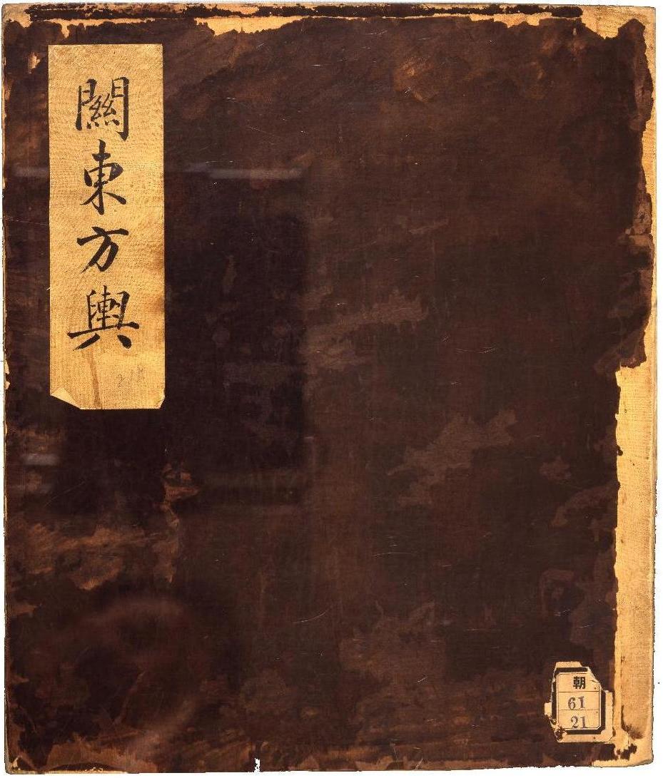
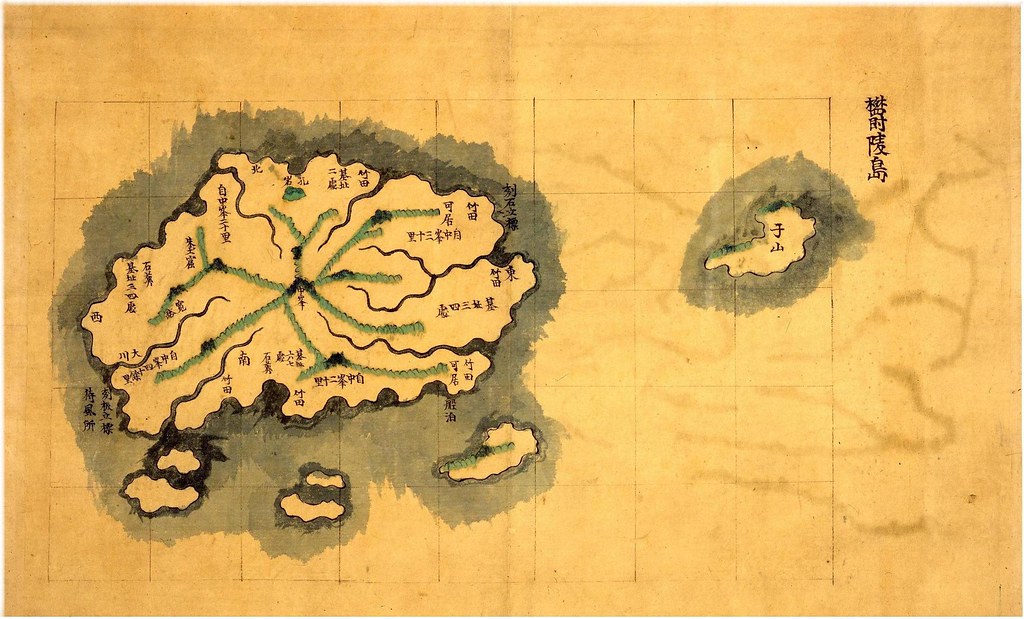
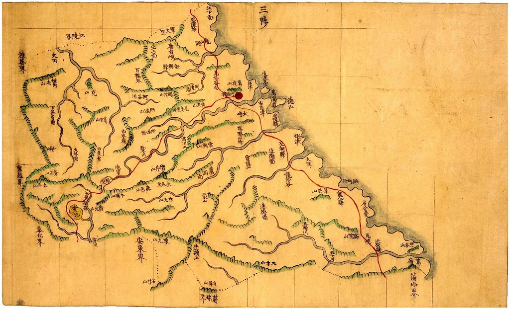
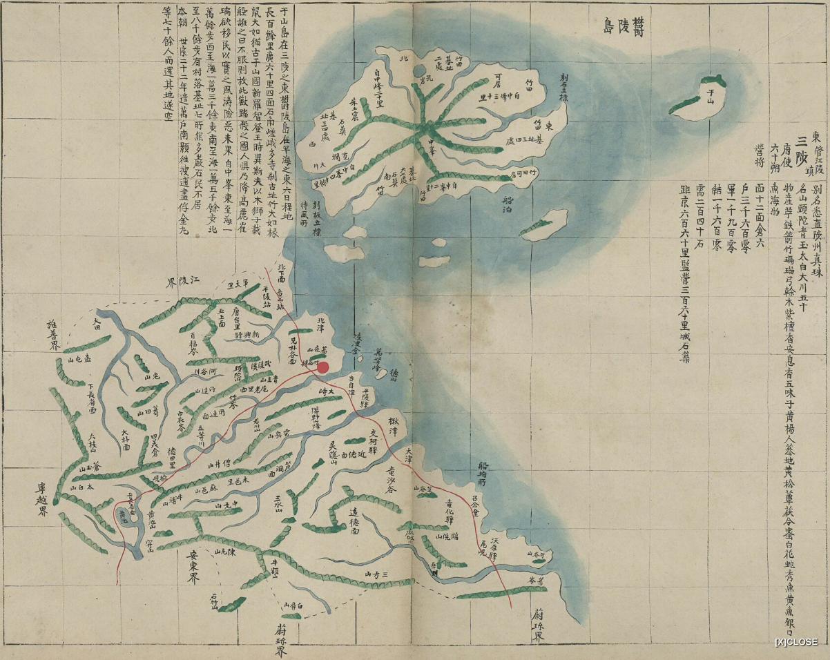
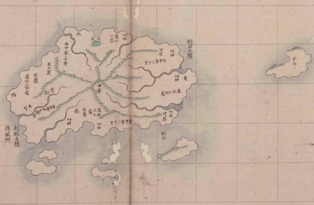
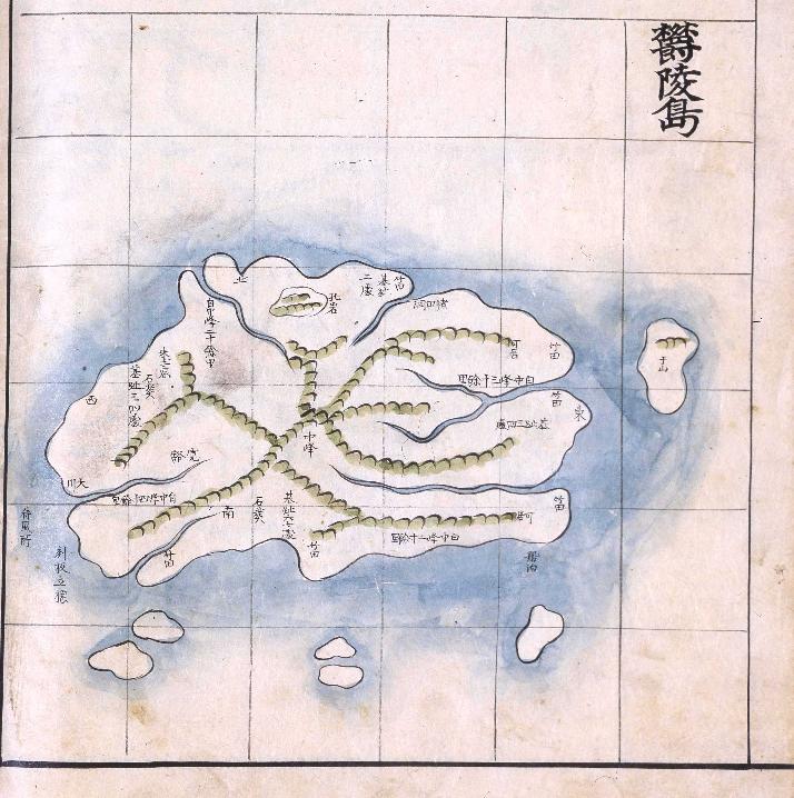
 Below are maps of Ulleungdo (鬱陵島) and Samcheok (三陟) from an atlas entitled "Gwandong Pangyeo" (關東方輿), which I believe was made sometime in the late 1800s. The atlas is stored in the National Library of Korea.
The reason I believe the atlas was made sometime in the late 1800s is that the maps are very similar to the maps that appear in an atlas labeled "地圖" (Maps), which is stored in Korea's Koryo University Musuem. The maps in the Koryo University Museum atlas were made sometime between 1884 and 1994.
If you look at both sets of maps below, you should notice that Ulleungdo was drawn in a similar way in both sets. Also, notice that both sets of maps used gridlines to show relative distance. The maps of Samcheok were also drawn in a similar way.
Both sets of maps of Ulleungdo show it with a neighboring island labeled as Usan (于山). The position of the island suggests that it was almost certainly Ulleungdo's neighboring island of Jukdo (竹島), which is only about two kilometers off Ulleungdo's east shore.
Also, there is an atlas stored in Seoul National University's Kyujanggak Institute of Korean Studies that is also drawn very similar to the other two maps of Ulleungdo shown here, but the people at Kyujanggak entitled "Joseon Jido" (朝鮮地島) that has a map very similar to the two posted here, but the people at Kyujanggak have dated the atlas as having been made sometime between 1750 and 1768, which are dates that I think should be reevaluated considering that we know for sure that the Koryo University Museum map was made after 1884.
Some Korean historians claim that Usando (于山島) was the old Korean name for Liancourt Rocks (Dokdo), but the maps below and all of Korea's other old maps of Ulleungdo showing Usando prove that claim wrong. In fact, Korea has no old maps showing Liancourt Rocks by any name, nor does Korea have any documents indicating that Koreans traveled to Liancourt Rocks before the Japanese started taking them there on Japanese fishing boats in the early 1900s. Moveover, the few Korean documents that do mention an island that is visible in the distance to the east of Ulleungdo refer to it as if it were Japanese territory. See HERE.
By the way, on the "Gwandong Bangyeo" atlas map of Samcheok (三陟), doesn't it look as if something were erased or covered over in the upper right-hand corner of the map? I wonder if there used to be writing similar to the writing that appears on the Koryo University map.
"Gwandong Bangyeo" - Ulleungdo & Samckeok - late 1800s (Korea's National Library)
"Jido" Samcheok & Ulleungdo - between 1884 - 1994 (Koyro Univesity Museum)
"Joseon Jido" -Ulleungdo - 1750-1768? (Seoul Nat'l Univ. Kyujanggak Inst. of Korean Studies)
Here is another gridline Ulleungdo map, but the islands were drawn slightly differently from the maps above, which suggests it was drawn at a different time. In fact, the map is believed to have been drawn sometime between 1776 and 1795.
"Haedong Yeojido" - Ulleungdo - 1776 - 1795 (Korean National Library)
Gerry,
ReplyDeleteDetailed Ulleungdo map with Gridline is exist on (late) 18C.
1776-1795.c.a海東輿地圖 古2107-36(But I forgot who explain the year the map above)
GTOMR,
ReplyDeleteYou are right, GTOMR. I forgot about the "Haedong Yeojido" (海東輿地圖). It was also a grid map. In fact, I think it was supposed to be the first, but I am not so sure about the dates.
The only thing we know for sure about the Haedong Yeojido is that it was made after 1776 because it shows a place in Pyeongan Province labeled as 楚山 (초산). The name was changed from 理山 (이산) to 楚山 (초산) is 1776. See HERE.
Also, it shows the following two placenames, 安義(안의) and 山淸(산청), which used to be 安陰(안음) and 山陰(삼음), respectively. They got their new names in 1767. See HEREBecause the map shows 衿川 (금천) instead of 始興 (시흥) in Gyeonggi Province, the map is assumed to have been made before 1795 since the name was changed to 始興 in 1795. (See HERE.) Of course, the mapmaker could have simply overlooked the name change, which would mean the map could have been made later.
Anyway, the Ulleungdo map in the Haedong Yeojido was drawn differently from the other three Ulleungdo maps. For example, notice how Usan (于山) was drawn differently.
Anyway, I will correct my post. Thanks for pointing out that error.
このポストと直接関係無くて恐縮ですが、
ReplyDelete島根県のWeb竹島問題研究所5月27日付の、4月分質問への回答で紹介している高橋論文の地図は大変面白い地図だと思います。(質問2)
http://www.pref.shimane.lg.jp/soumu/web-takeshima/takeshima08/2007/record200904.html
この地図については、かつてGTOMRさんが、去年の12月ごろにこのサイトで紹介していますが、リンクされたサイトでは高橋論文の文字は読めるものの、地図はつぶれて不鮮明だったため、国会図書館関西館にある論文を取り寄せて実際に地図の図版をみました。
鬱陵島の西南側に「于山島」が描かれ、かつ一方で、鬱陵島の東側には、竹島=独島とみられる小さな島が描かれています。(「地図のしみ」と見えなくもないですが)
韓国の新聞の見出し風に、もじって言えば
「于山島が独島ではないことを証明する古地図、日本で発見!」
ということになると思っています。
論文39p 図2「朝鮮八道全図」-山口県文書館所蔵「毛利家文書 58絵図、22-2」
地図は、寛保2年(1742)のものとみられています。
竹島問題研究所でも関心を示していますが、ネット上でも地図が見えるようになると良いと思います
・・・・・・・・・・・・・・・・・・・・・・・・・・・・・・・
島根県のWeb竹島研究所引用
【質問2】
高橋公明「合成された地図--山口県文書館所蔵朝鮮八道総図」『東アジア海域史研究における史料の発掘と再解釈ー古地図・偽使史料・文学表現ー』(文部科学省科学研究費補助金研究成果報告書2008年3月刊行)に紹介されている朝鮮古地図の情報を求む。特に山口県文書館のホームページ上の目録に「萩藩当職山内広通と浜崎代官清水親全の命により描いた彩色図絵図」とある『朝鮮八道総図』、同じく「長井半左衛門組九郎右衛門より差出候写也とある彩色図」とされる『朝鮮国之図』の鬱陵島部分をカラー画像で見てみたい。
<回答>
ご質問にある山口県文書館所蔵の絵図については、Web竹島問題研究所でも関心を持っております。朝鮮八道総図については、ご指摘の高橋論文以外に、河村克典「朝鮮漂着民との関連で作成された朝鮮図」『山口県文書館研究紀要』24(1997)pp.1-17が、朝鮮国之図については、河村克典「山口県文書館蔵朝鮮国之図」『山口県文書館研究紀要』25(1998)pp.1-18が、それぞれ詳しく紹介しています。河村論文によれば、朝鮮八道総図には、隠岐の付近に「此湊ヨリ天気定竹嶌エ乗ル 凡百五十里余有之ト云」との記事、鬱陵島付近には「元禄六年伯耆国磯竹源左衛門ト云者竹島ヲ見出シ申之由是ヨリ伯耆出雲因幡之猟人参猟仕候所ニ其節朝鮮人も参双方論シ依之江戸御注進相成候所ニ対馬より朝鮮えも段々被取遣り有之終ニ朝鮮之鬱陵島ニ相決シ候事」との記事がそれぞれ記載されている由です。鬱陵島の中にも、山頂からの歩数、新増東国輿地勝覧と同様の記事、今は無人島である旨の記述等があると承知します。また、于山島が鬱陵島の西側に描かれているものの注記はない(朝鮮国之図には于山島そのものが描かれていない)ようです。写真は、今当方からネット提供できるものはありません。(事務局:総務課)
・・・・・・・・・・・・・・・・・・・・・・・・・・
matsu wrote;
ReplyDelete"鬱陵島の西南側に「于山島」が描かれ、かつ一方で、鬱陵島の東側には、竹島=独島とみられる小さな島が描かれています。(「地図のしみ」と見えなくもないですが)"
Tiny island to the east of Ulleungdo with Usando in southwest to Ulleungdo? I'd like to see the map. It is interesting that there are many Japan-made Korean maps in Edo era which shows Usando northwest or southwest of Ulleungdo, but no southeast.
江戸大節用海内蔵
This comment has been removed by the author.
ReplyDelete第24号(1997.3)【研究】・朝鮮漂着民との関連で作成された朝鮮図 河村 克典
ReplyDelete【 書誌情報 】
第25号(1998.3)【研究】山口県文書館蔵「朝鮮国之図」の内容とその系統本 河村 克典
【 書誌情報 】
1742.朝鮮八道総図 萩藩当職山内広通と浜崎代官清水親全の命により描いた彩色図。22-1
1742.朝鮮八道総図 萩藩当職山内広通と浜崎代官清水親全の命により描いた彩色図。22-1
year unknown 朝鮮国之図 58絵図23「長井半左衛門組九郎右衛門より差出候写也」とある彩色図
----------------------------
another interesting old map collection in Tokyo.
some of them we can check it web takeshima, but three map cannot confirm which map they refer to.
「朝鮮図」〔請求番号:史199-4〕
「朝鮮国図」〔請求番号:178-449〕(On Web Takesshima -(1)国立公文書館所蔵- 3)
「朝鮮八道図」〔請求番号:177-0211〕 (On Web Takesshima -(1)国立公文書館所蔵- 1)
「朝鮮国図」〔請求番号:178-446〕(On Web Takesshima -(1)国立公文書館所蔵- 41)
「朝鮮国地図」(外題「亜細亜大洲辰旦属朝鮮輿地図」)〔請求番号:177-0001第201冊〕
「朝鮮輿地図」(外題「朝鮮輿地」、内題「亜細亜大洲之裏陸朝鮮国絵図」)〔請求番号:177-0001、第200冊〕
Kaneganese,
ReplyDeleteI forgot where the 高橋's article.
But the Korean peinsula map on his article is traditional-style Joseon design map , not japanese -draw nJapanese/chinese style map like 江戸大節用海内蔵.
Also 高橋's survey on 天理大学,there are some map.
ReplyDelete高橋公明論文
ReplyDeletehttp://ir.nul.nagoya-u.ac.jp/dspace/bitstream/2237/10609/1/%E5%90%88%E6%88%90%E3%81%95%E3%82%8C%E3%81%9F%E5%9C%B0%E5%9B%B3.pdf
・・・・・・・・・・・・・・・・・・・・・・・・・・・・・・・・・・・
GTOMRさんの紹介
http://dokdo-or-takeshima.blogspot.com/2008/06/11th-column-seeking-truth-based-solely.html?showComment=1229321820000
(12月15日) 3.17pm 現状で下から4番目
By the way any1 doesn't know this 2 korean peninsula map in the doccument below?
http://ir.nul.nagoya-u.ac.jp/dspace/bitstream/2237/10609/1/%E5%90%88%E6%88%90%E3%81%95%E3%82%8C%E3%81%9F%E5%9C%B0%E5%9B%B3.pdf
1742.朝鮮八道総図 58絵図22-1 と22-2
http://ymonjo.ysn21.jp/show/sh_ref_data.asp?refno=58%8AG%90}22-1
http://ymonjo.ysn21.jp/show/sh_ref_data.asp?refno=58%8AG%90}22-2
萩藩当職山内広通と浜崎代官清水親全の命により描いた彩色図
? 朝鮮国之図 58絵図23
http://ymonjo.ysn21.jp/show/sh_ref_data.asp?refno=58%8AG%90}23
「長井半左衛門組九郎右衛門より差出候写也」とある彩色図
・・・・・・・・・・・・・・・・・・・・・・・・・・・・・・・・・・・・・・・・・・
高橋公明論文
国会図書館
http://opac.ndl.go.jp/recordid/000009581540/jpn
請求記号 Y151-H17320093
タイトル 東アジア海域史研究における史料の発掘と再解釈 : 古地図・偽使史料・文学表現
責任表示 高橋公明,名古屋大学[著]
出版者 [高橋公明]
出版年 2005-2007
出版年 2008.3
形態 198p
注記 文部科学省科学研究費補助金研究成果報告書
注記 その他のタイトル: 研究種目 基盤研究(B)
科研費課題番号 17320093
個人著者標目 高橋, 公明 ∥タカハシ,キミアキ
団体・会議名標目 名古屋大学 ∥ナゴヤ ダイガク
非統制件名 海域史 / テキスト / 地図 / 文学 / 偽使
NDLC Y151
本文の言語コード jpn: 日本語
書誌ID 000009581540
・・・・・・・・・・・・・・・・・・・・・・・・・・・・・・・・・
Thanks, I forgot where I did post about the 高橋 Article. The interesting point is as follows;
ReplyDeleteP37.
隠岐諸島と鬱陵島の間の海域の描き方に明確な違いが認められる。まず、共通点から確認する。日本側の地域では、海路を現わす赤い線が多くひかれている
島前、「ミオ」(美穂関)から島後に日本の線がひ
ほとんど陸路を現わしており、海路では対馬島と「釜山浦」を結ぶ線と、この「蔚珍浦」から「于山島」を経由して鬱陵島の西側まで引かれている線しかない。この例外的な表現から推定すると、朝鮮半島から延びる日本の赤い線は、この地図作成時に追加されたのではないだろうか。地図製作者の海路に関する関心の高さを表すものであろう。
「全図」になると、さらに海路への深い関心が表現される。隠岐の島後と鬱陵島の東側も赤い線で結んでしまうのである。隠岐諸島から鬱陵島への漁民が頻繁に出漁などこの海域における人々の活動が地図の中で視覚化されたということである。
はないだろうか。
This is from matsu.
ReplyDelete1742 朝鮮八道総図 58絵図 萩藩当職山内広通と浜崎代官清水親全の命により描いた彩色図
22-122-2From the map, it is apparent Japanese in Hagi(today's one of Yamaguchi Pref. and next to Shimane) country in mid 1700s considered Usando locates Southwest of Ulleungdo and nearer to Korean peninsula.
GTOMR,
ReplyDeleteThank you for the information.
Gerry,
I think "島" in "地島" (Maps), "Joseon Jido" (朝鮮地島) should be "圖".
Thank you Kaneganese,
ReplyDeleteIn the map, the red line (ship line) from Oki to Ulleungdo first goes straight to the “island”, and then goes southwestward to Ulleungdo.
That’s why I think it shows Takeshima/Dokto.
But still it might be just a “spot”.
I hope 山口県文書館 will open clear picture of the map.
http://ymonjo.ysn21.jp/show/sh_ref_data.asp?refno=58%8AG%90}22-2
Thanks uploading the images.
ReplyDeleteI tried zoom up with some trimming analysis
1.
2.
3.
Zooming up with some trimming analysis, The spot seems some small rocks.But It is difficult to consider the spot is island ,compared with the size of text on Ulluengdo.
anyway need to check there.
if sending application and go there with camera, they will allow to took photo. But no giveaway service there.
If the spot is island, they would already have announced "we found a map described Liacnourt Rocks is territory of Japan",so I guess it is just a spot or bites.
Kaneganese wrote,
ReplyDelete1742 朝鮮八道総図 58絵図 萩藩当職山内広通と浜崎代官清水親全の命により描いた彩色図
Kaneganese,
That is an interesting map. See HERE. Is there anyway we can get a closeup of the Ulleungdo area?
Do you know what is written in the text box surrounding the small island to the east of Ulleungdo?
What else can you tell me about the map?
Gerry,
ReplyDeleteThe map is 「朝鮮八道総図」(1742 : 寛保二年) written by Japanese based on the story of castaways from Joseon to 長門国(Nagato Country : part of today's Yamaguchi Prefecture, which is next to Shimane, and it is a prorpety of Yamaguchi Prefectural Archives. Unfortunately, it isn't open to public on the web, so we have to go there to look closely. But Ulleungdo is between Usando and Oki. The other one (「朝鮮八道全図」) is much more interesting since it has red line from Oki through Ulleungdo and Usando to Korean peninsula.
I've just borrowed the article of the academic jounals, which has long explanation of the map in detail. I've been scanning all the photocopies matsu kindly lend to me for whole day and haven't really read what it says, yet. I'll read it tomorrow and comment on what the article says.
GTOMR,
I'll send you articles after I get a permission.
I've been talking about this map for the last few weeks if we should post this map or not. But I think we need clearer image of the map and professional opinion, so I am kind of waiting for the Shimane's Web Takeshima Center's study report or at least getting more good images. After reading Prof. Takahashi and Mr. Kawakami's article, it is very possible that they don't realize the importance of this map for the issue of Takeshima, unfortunately.
ReplyDeleteAnyway, below are the summary of the two articles on the maps.
1742「朝鮮八道總圖」(「毛利家文庫、五八絵図、22-1」)
1742「朝鮮八道全圖」(「毛利家文庫、五八絵図、22-2」)
萩藩当職山内広通と浜崎代官清水親全の命により描いた彩色図。
The colour map drawn by orders of principal retainer(当職) Yamauchi(山内広通) and Hamazaki prefectural governor (浜崎代官) Shimizu(清水親全).
According to Mr. Kawamura, a curator of the Archives, the explanation of this map written near Oki says,
「此湊ヨリ天気定竹嶌エ乗ル 凡百五十里余有之ト云」
From this port, they set sail to Takeshima. It is said that approximately 150-ris(300km).
And to the east of Ulleungdo, it says that
「元禄六年伯耆国磯竹源左衛門ト云者竹島ヲ見出シ申之由是ヨリ伯耆出雲因幡之猟人参猟仕候所ニ其節朝鮮人も参双方論シ依之江戸御注進相成候所ニ対馬より朝鮮えも段々被取遣り有之終ニ朝鮮之鬱陵島ニ相決シ候事」
In 1693(元禄六年), a Hohki Country(伯耆国) man, name of Isotake Genzaemon(磯竹源左衛門), declared discovery of Takeshima. And since then, hunters from the countries of Hohki, Izumo and Inaba(伯耆出雲因幡) went for hunting. Howver, Korean also joined. Both parties debated. The information was passed to Edo Bakuhu and Tshushima domain also dealed the matter only to decide the island was Joseon's Ulleungdo.
The descriptions on the map are categorized in to four.
1. Geography and the history of each part of Joseon.
2. Articles on Imjin War(文禄慶長の役)
3. Japanese embassy/settlement(倭館) in Busan
4. Article on Takeshima
In the explanation of "Article on Takeshima", Mr.Kawakami noted that "ここでは竹島のことが記されているが、本図の隠岐と鬱陵島の間には現在の竹島は描かれていない。( Although Takeshima was recorded on those maps, today's Takeshima was not drawn between Oki and Ulleungdo. )"
河村克典「朝鮮漂着民との関連で作成された朝鮮図」『山口県文書館研究紀要』24(1997)pp.1-17
This comment has been removed by the author.
ReplyDeleteAnd Prof. Takahashi of Nagoya University also wrotean article on this maps.
ReplyDeleteAccording to his article, the maps are distinctive of Tshushima, which usually drawn as a part of 慶尚道 (in Korean maps) but is drawn as a part of Japan with a different colour from 慶尚道. Two maps are almost the same except for some description. But a clear difference is admitted in the drawing style of the sea area between Oki Islands and Ulleungdo.
He commented on the red lines from Oki to Uljin, via Ulleungdo(Takeshima) and Usando.
"隠岐諸島と鬱陵島の間の海域の描き方に明確な違いが認められる。まず、共通点から確認する。日本側の地域では、海路を現わす赤い線が多くひかれているが、「総図」「全図」ともに「宇龍」から島前、「ミオ」(美穂関)から島後に二本の線がひかれている。朝鮮側の地域では赤い線はほとんど陸路を現しており、海路では対馬島と「釜山浦」を結ぶ線と、この「蔚珍浦」から「于山島」を経由して鬱陵島の西側まで引かれている線しかない。この例外的な表現から推定すると、朝鮮半島から延びる日本の赤い線は、この地図作成時に追加されたのではないだろうか。地図製作者の海路に関する関心の高さを表すものであろう。
「全図」になると、さらに海路への深い関心が表現される。隠岐の島後と鬱陵島の東側も赤い線で結んでしまうのである。隠岐諸島から鬱陵島への漁民が頻繁に出漁などこの海域における人々の活動が地図の中で視覚化されたということである。"
A clear difference (between two maps) is admitted in the drawing style of the sea area between Oki Islands and Ulleungdo. First of all, the common features of the description of the sea area in concren are, in the area of Japanese side, there are many red lines which represent searoutes and two lines are drawn from "宇龍" to "島前(Dozen of Oki)" and "Mihogaseki(美穂関)" to "島後(Dogo of Oki). While in the area of Joseon side, almost all red lines are representing land route except for the two lines from Tshushima to Busan Bay and "Uljin Bay(蔚珍浦)" to the west side of "Ulleungdo" via "Usando'. Considring this exceptional expression, it is presumed that the Japanese red lines (or red lines in Japan) streached from Joseon peninsula must have been added when they were made. It shows the mapmaker's strong interest for sea routes. As for 「全図」, more profound concern in the sea routes are described. Surprisingly, Dogo in Oki and the east of Ulleungdo was even connected with red line. In other words, the map visualizes the activity of people around this sea area, such as going out fishing from Oki islands to Ulleungdo frequently.
According to his articel, the explanation of this map written at the bottom says,
①この地図は『東国輿地勝覧』から正確に写し取ったものであること
This map was accuratly copied from "東国輿地勝覧".
②松原正軒が対馬宗家の「訳官」として朝鮮に滞在中に、「韓人」から朝鮮の歴史・地理に関する多くのことを聞き取ったこと、
Matsubara Seikenn(松原正軒) : interviewed "Korean(韓人)" to get many information of the history and the geography in Korea while staying in Joseon as a official translater of Tsushima clan.
③その松原正軒が長門国に来て、毛利家に雇われたこと、
Matsubara came to Country of Nagato(長門国 : part of Hagi/Choshu domain) and hired by Mohri clan.
④正軒の子正英が浜崎の「宰」である清水親全に命じられ、「舩蔵之館」において正確に写したものであること
Matsubara's son Siei or Shoei(正英) accuratly copied, by orders of Hamazaki prefectural governor (浜崎の「宰」) Shimizu(清水親全), at the mansion in ship warehouse "舩蔵之館".
⑤「対馬壱岐五島九州西北海辺」をそれに追加し、朝鮮人漂流民の応対用にしたこと
He added "Tsushima, Iki, Goto and the coast of northwest of Kyushu" to use for the reception of the drifted Korean.
高橋公明「合成された地図--山口県文書館所蔵朝鮮八道総図」『東アジア海域史研究における史料の発掘と再解釈ー古地図・偽使史料・文学表現ー』(文部科学省科学研究費補助金研究成果報告書2008年3月刊行)
By the way, Hagi Domain was also called Choshu Domain and people from this domain played the key role in the process of Meiji Reformation, including Ito Hirobumi(伊藤博文). It is interesting for me to get to know that Samurais in Choshu must have known about Usando being placed to the west of Ulleungdo.
Hagi, Yamaguchi (萩 : 山口)
Choshu Domain(Chōshū : 長州藩)
Kaneganese wrote;
ReplyDeleteAfter reading Prof. Takahashi and Mr. Kawakami's article, it is very possible that they don't realize the importance of this map for the issue of Takeshima, unfortunately.
I agree.
・・・・・・・・・・・・・・・・・・・・・・・・
島根県では、「写真は、今当方からネット提供できるものはありません。」としています。
http://www.pref.shimane.lg.jp/soumu/web-takeshima/takeshima08/2007/record200904.html
(質問2)
これまでも、上のコメントで紹介されていますが、ここでまとめてみます。
いずれも、およそ「畳3枚ぶん」の、とても大きい地図です。
下記高橋論文のPDFの、つぶれてしまっている地図の写真よりは、わかりやすいと思います。
1742「朝鮮八道總圖」(「毛利家文庫、五八絵図、22-1」)
http://farm3.static.flickr.com/2450/3588811031_0071834a5d_o.jpg
図1 高橋論文38p
縦275×横205センチ
1742「朝鮮八道全圖」(「毛利家文庫、五八絵図、22-2」)
http://farm4.static.flickr.com/3623/3588811097_870b1fda95_o.jpg
図2 高橋論文39p
縦266×横192センチ(少し、小さい)(こちらが、やや新しい)
この地図に、以下を結ぶ「赤い線」あり
隠岐―鬱陵島―于山島―蔚珍浦(朝鮮半島)
隠岐と鬱陵島の間に「竹島=独島」あり?(画像が不鮮明で分からない)
「山口県文書館」が鮮明な地図の画像をネットに公開してくれることを望みます。
高橋論文
高橋公明「合成された地図--山口県文書館所蔵朝鮮八道総図」『東アジア海域史研究における史料の発掘と再解釈ー古地図・偽使史料・文学表現ー』(文部科学省科学研究費補助金研究成果報告書2008年3月刊行)
http://ir.nul.nagoya-u.ac.jp/dspace/bitstream/2237/10609/1/%E5%90%88%E6%88%90%E3%81%95%E3%82%8C%E3%81%9F%E5%9C%B0%E5%9B%B3.pdf
Kaneganese,
ReplyDeleteMaybe you could start a post with GTOMR's map HERE, since it is fairly clear, and change the map later when we get a more detailed map?
Starting a new post for the map would give us a place to discuss it. I could start the post, but you know more about the map than I do, so I think it would be better if you started it. What do you think?
This comment has been removed by the author.
ReplyDeleteI guess Prof. Takahashi having a clear image of the map? he is in Nagoya Univ. same with prof.Ikeuchi.
ReplyDeletewhat about try to contact with him? I dont think Yamaguchi document office will upload images if nobody requested or asked them. also they dont do copy giveaway service so need to go directly by ourselves if need detail clear images.
Gerry,
ReplyDeleteGive me two months. I'm going to Shimane in August, and I'll visit Yamaguchi, too. They have many other documents I'd like to see anyway. Besides, the image I uploaded was from Takahashi's article which matsu sent to me. So I'm not sure we can use this or not on the net. I think it would be better I go myself and ask Yamaguchi Prefectural Archives permission directly.
GTOMR,
Please make your request list of documents and maps they have until the end of July. (Don't expect the quality of photo too much. I'm not good at taking photos.)
Gerry Bevers wrote:
ReplyDelete"Both sets of maps of Ulleungdo show it with a neighboring island labeled as Usan (于山). The position of the island suggests that it was almost certainly Ulleungdo's neighboring island of Jukdo (竹島), which is only about two kilometers off Ulleungdo's east shore."
Don't you think you need to give more detailed explanation about your bold concluding the island labeled "于山 (Usna)" is 竹島(Jukdo) for the ignorant readers?