竹島問題の歴史

31.7.08

1530 - "Paldo Chongdo" (八道總圖) - "Map of the Eight Provinces"

The map below is called the "Paldo Chongdo" ((八道總圖 - 팔도총도) and comes from the "Sinjeung Dongguk Yeoji Seungram" (新增東國輿地勝覽 - 신증동국여지승람), which was a 55-volume set of Joseon government geography books published in 1530. The books were an updated version of a 50-volume set of books that were first compiled in 1481, revised to a 55-volume set in 1486, and published in 1487.

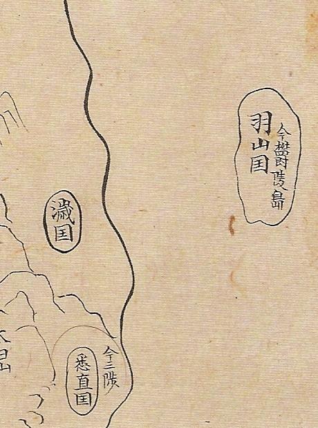
This 1530 map was the first Korean map, still in existence, to show the Korean island of Ulleungdo (鬱陵島 - 울릉도) with a neighboring island off its west shore labeled as "Usando" (于山島 - 우산도), which Koreans claim was the old Korean name for Dokdo (Liancourt Rocks).

Click twice on the map to enlarge.


The problem with using the above map to claim that Usando (于山島) was the old name for Dokdo is that is shows Usando to the west of Ulleungdo, but Dokdo is ninety-two kilometers southeast of Ulleungdo. Look at the following cutout of the section of the map showing Ulleungdo (鬱陵島) and Usando (于山島).


There is no neighboring island to the west of Ulleungdo, so how can the above map be explained?

It can be explained because Ulleungdo has a small neighboring island 2.2 kilometers off its east shore that caused the two islands to be confused. The confusion started in 1412, when a group of twelve people sailed into the habor at Koseong (高城 - 고성) and said they came from an island called "Yusanguk-do (流山國島 - 유산국도), which was a misspelling of the island of Usanguk (于山國 - 우산국). In other words, they were saying they came from Ulleungdo.

So how does this explain why Usando was drawn off the west coast of Ulleungdo on the above map?

In their testimony to Korean officials, the islanders said that sixty of them had lived on an island named "Muleungdo" (武陵島 - 무릉도), but later moved to the "main island" (本島 - 본도). This tells us that Muleungdo was the smaller of the two islands and that Yusanguk-do (Usando) was the main island. Muleungdo (武陵島) was the spelling of Ulleungdo (鬱陵島) during most of the 1400s.

This was the first time that Ulleungdo (Usanguk) had been described as having a neighboring island, and it caused Korean officials to start thinking of Usando as the main island and Ulleungdo (Muleungdo) as its smaller neighboring island. This explains why Usando was drawn to the west of Ulleungdo on almost all of Korea's maps of Ulleungdo before the An Yong-bok (安龍福 - 안용복) incident in the 1690s.

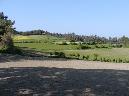
We know that the neigboring island described by the people in the 1412 record was not Dokdo (Liancourt Rocks) because they said that sixty of them had lived on it, but Dokdo is just barren rocks that could not support sixty people. Therefore, the neighboring island described in the record had to be Ulleungdo's neighboring island of Jukdo, which is 2.2 kilometers off Ulleungdo's east shore. Jukdo does not have any water, so they would have had to live by gathering rainwater, but Jukdo would have been much easier to defend than Ulleungdo.

Here is a picture of Ulleungdo's neighboring island of Jukdo from the Ohmynews Web site:


The following is the 1412 record from the "Annals of King Taejong" (太宗實錄 - 태종실록), a Korean translation from the Northeast Asian History Foundation Web site, and my English translation:
命議政府議處流山國島人 江原道觀察使報云 流山國島人 白加勿等十二名 求泊高城 於羅津言曰 予等生長武陵 其島內人戶十一 男女共六十餘 今移居本島 是島自東至西自南至北 皆二息 周 回八息 無牛馬水田 唯種豆一斗出二十石 或三十石 麥一石出五十餘石 竹如大椽 海錯果木皆在焉 竊慮此人等逃還 姑分置于通州高城扞[杆]城

-------------------

의정부(議政府)에 명하여 유산국도(流山國島) 사람을 처리하는 방법을 의논하였다. 강원도 관찰사가 보고하였다. “유산국도(流山國島) 사람 백가물(百加勿) 등 12명이 고성(高城) 어라진(於羅津)에 와서 정박하여 말하기를, ‘우리들은 무릉도(武陵島)에서 생장하였는데, 그 섬 안의 인호(人戶)가 11호이고, 남녀가 모두 60여 명인데, 지금은 본도(本島)로 옮겨 와 살고 있습니다. 이 섬이 동에서 서까지 남에서 북까지가 모두 2식(息) 거리이고, 둘레가 8식(息) 거리입니다. 우마(牛馬)와 논이 없으나, 오직 콩 한 말만 심으면 20석 혹은 30석이 나고, 보리 1석을 심으면 50여 석이 납니다. 대[竹]가 큰 서까래 같고, 해착(海錯)과 과목(果木)이 모두 있습니다.’고 하였습니다. 이 사람들이 도망하여 갈까 염려하여, 아직 통주(通州)·고성(高城)·간성(扞城)에 나누어 두었습니다.”

-------------------

In accordance with Uijongbu orders, methods for dealing with the people of Yusanguk-do were discussed. The governor of Kangwon Province reported, "Twelve people from Yusanguk-do, including Baek Ga-mul, came and anchored at Eorajin in Koseong and said the following:

"Twelve families of us lived on Mu-leungdo with a total of more than sixty men and women, but now we have moved to the main island and are living there. The island's distances from east to west and north to south are each two shik (60 ri), and its circumference is eight shik (240 ri). There are no cows or horses or rice paddies on the island, but if we plant just one mal of beans, we harvest twenty to thirty seok. If we plant one seok of barley, we harvest more than fifty seok. The bamboo are as big as rafters, and there are all kinds of sea products and fruit trees."

Fearing that they may try to run away, they were divided up and put at Tongju, Koseong, and Ganseong, where they are still.


"US Reinstates S. Korean Sovereignty Over Dokdo"

A July 31 Korea Times article entitled, "US Reinstates S. Korean Sovereignty Over Dokdo," reports that the US Board of Geographic Names (BGN) has revised its description of Liancourt Rocks to being under Korean sovereignty. Last week the BGN had changed the description of Ulleungdo to "undesignated sovereignty," angering many South Koreans.

A US government spokesman had said that "undesignated sovereignty" reflected the US view of neutrality in regard to the sovereignty dispute, but after receiving a phone call for a "high-level" Korean government official, President Bush ordered that the description be revised to the way it was before the change.

"US Reinstates S. Korean Sovereignty Over Dokdo"

1600s - Map of Silla, Goguryo, & Baekje Regions

The map below is from a 1600s atlas entitled "Old Maps of China & Joseon" (支那朝鮮古地圖 - 지나조선고지도), which is stored in the National Library of Korea (國立中央圖書館 - 국립중앙도서관). The map is entitled "Map of the Original Regions of Silla, Goguryo, and Baekje" (新羅高勾麗百濟肇造區域之圖 - 신라고구려백제조조구역지도).

Double click on the map to enlarge.


Below is a cutout from the map that shows a single island off the east coast of Korea labeled as "Usan-guk - now Ulleungdo" (羽山國 今 鬱陵島 - 우산국, 지금 울릉도). This map is more evidence that Usan-guk was recognized as only one island, not two, during the time of the Silla Kingdom.

Q1: Has Dokdo been a part of Korea since the sixth century?

Answer: Koreans claim that Liancourt Rocks (Dokdo) has been a part of Korean territory since the time of the Silla Kingdom (512 A.D.), but Korea has no maps or documents to back up the claim. They say, however, that they do have evidence and, as one example, they point to Korea's Samguk Sagi (三國史記: "History of the Three Kingdoms"), which was written in 1145 A.D.
In the Samguk Sagi, a reference was made to an island due east of "Myeongju" (present-day Gangeung) named "Usanguk" (于山國 - 우산국). Koreans claim that Usanguk was referring to both Ulleungdo and Dokdo (Liancourt Rocks); however, though Ulleungdo was mentioned as another name for Usanguk, nothing was mentioned about Dokdo (Liancourt Rocks), by any name. In fact, the text gives the bearing and area for only one island.
The map to the left comes from an atlas made in the 1600s entitled, "Old Maps of China & Joseon" (支那朝鮮古地圖 - 지나조선고지도), which is stored in the National Library of Korea (國立中央圖書館 - 국립중앙도서관). The title of the map is "Map of the Original Regions of Silla, Goguryo, and Baekje" (新羅高勾麗百濟肇造區域之圖 - 신라고구려백제조조구역지도). The map shows a single island off the east coast of Korea labeled as "Usanguk - now Ulleungdo" (羽山國 今 鬱陵島 - 우산국, 지금 울릉도). This map is more evidence that Usanguk was considered to be just one island, not two.
Though later in the Joseon Dynasty, Koreans would discover that Ulleungdo had a neighboring island about 2.2 kilometers off its east shore, which today is called "Jukdo" (竹島), there is no evidence that Dokdo (Liancourt Rocks), which is ninety-two kilometers southeast of Ulleungdo, was ever considered a part of Usanguk, Ulleungdo, or any part of Korean. In fact, Korea has no old maps of Liancourt Rocks under any name and has no documents showing that Koreans ever went there before Japanese fishing boats starting carrying Korean fishermen there in the early 1900s. The Korean claim simply has no evidence to support it.
The follow is a quote from a document on the Korean Embassy Web site entitled "Dokdo: Korean Territory Since the Sixth Century" - PDF or HTML, which claims that Dokdo (Liancourt Rocks) has been a part of Korean territory since the sixth century.
Korean Claim

1. When Did Dokdo Become a Part of Korean Territory?

Korean title to Dokdo dates back to the 6th century. According to the records of Samguk Sagi (History of the Three Kingdoms), Korean sovereignty over the island was established with the incorporation of Usanguk (“guk” means “state”) into the Kingdom of Silla, one of the three ancient kingdoms of Korea, in 512 A.D. Samguk Sagi records that in 512 A.D., Yi Sa-bu, a Silla government official, subjugated the island state on behalf of Silla. The territory of Usanguk comprised the islands of Ulleungdo and Usando (present-day Dokdo)....

1. 언제 독도는 한국의 영토가 되었는가?

독도가 대한민국 고유의 영토라는 근거는 서기 6세기로 거슬러 올라간다. 독도에 관한 최초의 기록은 서기 512년에 신라의 이사부가 나무로 만든 사자를 이용한 계교로써 우산국을 정복하였다는 삼국사기의기록이다. 당시 우산국의 영토는 울릉도 본 섬과 그 부속도서인 독도 등으로 구성되어 있었으며, 동해에 울릉도와 독도 두 개의 섬이 존재하고 있다는 우리 조상들의 지리적 인식은 그 후 조선시대에 간행된 세종실록지리지(1454)와 동국여지승람(1531)에도 잘 나와 있다. 특히 이 두 개의 책에 수록된 팔도총도와 강원도 지도에는 독도가 조선의강원도에 속하는 섬임이 명확하게 표시되어있다.

The Truth
Let's look at what was actually written in Korea's Samguk Sagi.

Here is the section from the "Silla Bongi" (新羅本記 - 신라본기) in Volume 4 (券4) of the Samguk Sagi (三國史記 - 삼국사기) that Koreans claim proves that Dokdo has been Korean territory since the sixth century:

十三年 夏六月 于山國歸服 歲以土宜爲貢 于山國在溟州正東海島 或名鬱陵島 地方一百里 恃嶮不服 伊飡 異斯夫 爲何瑟羅州 軍主 謂 “于山人愚悍 難以威來 可以計服” 乃多造木偶師子 分載戰船 抵 其國海岸 誑告曰 “汝若不服 則放此猛獸踏殺之” 國人恐懼 則降

------------------------

In May in the summer of the 13th year (512 A.D.), Usan-guk surrendered and began paying annual tributes in local products. Usan-guk is an island in the sea due east of Myeongju [present-day Kangneung]. It is also called Ulleungdo. It has an area of 100 ri. The land was believed to be too rugged to conquer.

When government official Lee Sa-bu became commander of Haseullaju, he said, “The people of Usan-guk are ignorant and savage and would be difficult to subdue by force, but we can use cunning.” Then he made many wooden lion figures, divided them up, and loaded them on warships. On the shore of the country, he deceitfully said, “If you do not surrender, we will release these ferocious animals and you will be trampled to death. The country’s people became so frightened that they immediately surrendered.

-----------------------

13년(512) 여름 5월에 우산국(于山國)이 항복하여 해마다 토산물을 바쳤다. 우산국은 명주(溟州)의 정동쪽 바다에 있는 섬으로 혹은 울릉도(鬱陵島)라고도 한다. 땅은 사방 100인데, 지세가 험한 것을 믿고 항복하지 않았다. 이찬 이사부(異斯夫)가 하슬라주(何瑟羅州) 군주가 되어 말하기를 “우산국 사람은 어리석고도 사나워서 힘으로 복속시키기는 어려우나 꾀로는 복속시킬 수 있다.”하고, 이에 나무 사자를 많이 만들어 전함에 나누어 싣고 그 나라 해안에 이르러 거짓으로 “너희가 만약 항복하지 않으면 이 사나운 짐승을 풀어 밟아 죽이겠다.”고 말하자 그 나라 사람들이 두려워 곧 항복하였다.

As you can see from the above translation, nothing was said about Dokdo or Liancourt Rocks under any name. It only said that Usanguk was due east of Myeongju, which was a village on the east coast of Korea that is presently called Gangneung, and that Ulleungdo was another name for Usanguk. This proves false the Korean claim that the Samguk Saji supports Korea's claim to Dokdo.

The following is a scan of the relevant page from the Samguk Sagi (三國史記 - 삼국사기).

28.7.08

"Lee, Bush to Discuss Dokdo"

By trying to take a more neutral stance by describing Liancourt Rocks as "undesignated sovereignty," it appears that the US Board of Geographic Names has created a situation in which the US is in danger of being dragged into the Korea-Japan dispute over the sovereignty of the rocks. "Lee, Bush to Discuss Dokdo"

However, a U.S. expert suggests that it is a bad idea for Korea to make a fuss about "Dokdo."
"The ROK is in possession of Dokdo and that will not change," Straub said, referring to South Korea's official name of the Republic of Korea. "The international community basically isn't even aware of the controversy between Japan and the ROK over Dokdo, much less engaged about it, and it is in the ROK's interests to keep it that way."

"Expert: S. Korea should ignore Dokdo claim"

As the US expert said, it is in South Korea's interests to keep the world unaware of "Dokdo" because if it becomes an international issue, there is a danger that the truth about Dokdo will come out, and the truth will not be on Korea's side. However, the gene that would allow Koreans to be able to ignore Japanese claims on "Dokdo" does not seem to be in Korean DNA.

27.7.08

"US Office No Longer Regards Dokdo as Korean Territory"

The following is a link to a July 27 article from the Korea Times:

"US Office No Longer Regards Dokdo as Korean Territory"

According to the article, the U.S. Board on Geographic Names has revised its description of Liancount Rocks (Dokdo) to take a more neutral stance on the sovereignty of the rocks. Thought the US office has been using the name "Liancourt Rocks" to refer to the islets since 1977, it had been describing the rocks as being under Korean control until recently changing it to "undesignated sovereignty."

Also, according to another article, Koreans are upset that "Takesima" comes before "Tok-to" in a list of alternate names used for the Liancourt Rocks, but that is probably just because "Takesima" comes before "Tokto" alphabetically. (I smell another name war brewing.)

Anyway, as you might expect, Korea's "Netizens" are upset, according to THIS KOREAN ARTICLE. Here are some of the Netizen comments mentioned in the article:
  • How can this happen after having listened to Bush's pet dog barking in the US? Is our alliance broken?
    "미국에서 부시 애완견소리까지 들었는데 이거 어찌 된겁니까. 한미 동맹 깨진겁니까?"
    .
  • "VANK, Netizens! Put pressure on the US. The US was certainly not our friend. They just watched over us for their own defense, but not now."
    "반크여, 네티즌이여! 미국을 압력하라. 미국은 절대 우리친구가 아니었다”며 “자기들의 방위를 위하여 우리를 지켜주었다.이제는 아니다."

  • "Some blood alliance! They seem to be saying that Korea's territory, Dokdo, is ownerless to prepare the way to forcefully take it for themselves."
    "혈맹관계라더니 한국의 영토인 독도를 주인이 없다 하는것은 차제에 자신들도 힘으로 쟁취할 수 있는 길을 만든 셈이다."
Here is what they are upset about. Click to enlarge.

25.7.08

Ampontan Compares Kor & Jpn Editorials on the Current Dispute

Ampontan has come up with another great post that compares how Japanese newspapers are editorializing the current Dokdo/Takeshima dispute with how Korean newspapers are doing it.

"Japanese and South Korean editorials on Takeshima: A comparison"

Ampontan on Korea's Reaction to the Current Takeshima Controversy

The following is a link to an interesting post by Ampontan, who writes about Japan and Japanese issues:

Seoul's choice: Busan or Takeshima

24.7.08

1904 The Seat of the Japan-Russian War

This is an American map of Japan and Korea in 1904, which was called "THE SEAT OF THE JAPAN-RUSSIAN WAR" . It was compiled from the "latest" U.S. Consular, War and Navy Departments' Reports, Railway and Concession Surveys. It was literally published during the Russo-Japanese War.
The year 1904 was four years after the Korea's Imperial Edict #41, which mentioned Seokdo, and one year before the incorporation of Takeshima (Liancourt Rocks) into Shimane prefecture of Japan.
Although it may be a little hard to identify the colour of the islands in the Japanese Sea, all the islands including "Taka I", "Dagelet I", "Matsu I (with Boussole Rocks)", "Liancourt Is. (To France)" and "Hornet I. (To England)" were coloured in pink (horizontal pink line) - the same as Japan's mainland. (Korea was coloured in light purple with longitudinal and horizontal lines)


You may notice that there are two Ulleungdos (Dagelet I and Matsu I) and two Liancourt Rcoks (Liancourt I and Hornet I). Although the information was inaccurate, this map clearly shows that USA didn't think that Liancourt Rocks to be Korean territory even after the 1900 Imperial Edict and before the incorporation of Takeshima (Liancourt Rocks).


Please notice the colour of the islands including Liancourt Rcoks (pink horizontal line) which is the same as Japan (left), and different from Korea (right; purple longitudinal and horizontal crossing lines).

In the Process of Changing the Blog Menu

I have changed the headings in our Blog's Title bar to headings leading to indices of blog articles in English, Korean, and Japanese. It may be a little while before the list of articles in the different indices are completed, however, since I work pretty slow. The Japanese index, however, looks to be pretty well completed.

I am still considering other ways to improve the blog, so if anyone has any ideas, please let me know.

23.7.08

They insist that Tsushima was Korean territory

According to Chosun Online, a professor Song Sun-cheol (may not exact) of Kangwon University insists that Tsushima was Korean territory showing the 1549 Japanese map of Korea, "朝鮮国地理図". http://www.chosunonline.com/article/20080717000015
Actually Tsushima was drawn but it may have been drawn because it is located at near Chosun. One can't claim ownership from this kind of map.

When the local government of Tsushima sent treasure (gold) to the Imperial Court of Japan in 701 AD, emperor was glad to have the gift and gave the name of the era Taiho (大宝, treasure). So at least Tsushima was Japanese territory in 701 AD. And in the 魏志倭人伝, the old record of China (陳寿 233~297 AD) also referred to Tsushima as a part of Japanese counties. So the scholar's theory is out of question.

By the way, in this map Usando was drawn at the west of Ulleungdo. This map was another proof that Usando was not Liancourt Rocks. The professor may have shot his own foot.

Comments will now be moderated.

Too many silly comments have been made on this blog recently, so I have changed the settings to allow me to review comments before they are posted. If comments are serious and related to the topic, regardless of which side of the debate they may be on, they will be posted; otherwise, they will not. This restriction will not apply to my fellow blog managers.

If I had the ability to add approved commenters, I would since we have many regular commenters who contribute a great deal to the blog, but there is no such option in blogger, as far as I know.

I apologize for any inconvenience. Comments will still be posted as soon as I get a chance to review them, so please continue to comment.

22.7.08

New, old map of Ulleungdo?

Can someone tell me what is said HERE about the map shown below?


1894 Jpn Gazetteer: Usando "in the vicinity of Ulleungdo" (于山島:蔚陵島ノ近傍)

HERE is a link a page from a 1894 Japanese gazetteer entitled "Guide to Joseon Placenames" (朝鮮地名案内), which, on page 159, describing Usando (于山島 - 우산도) as follows:

Oul-neung-to 蔚陵島 朝鮮ノ東海岸ニアリ
Oul-neung-to, Ulleungdo (蔚陵島) sits off the east coast of Joseon (朝鮮)

Ou-san 于山島 朝鮮ノ東方 蔚陵島ノ近傍
Ou-san, Usando (于山島), East of Joseon (朝鮮ノ東方), in the vicinity of Ulleungdo (蔚陵島ノ近傍)

Notice that the gazetter describes Usando as being "in the vicinity of Ulleungdo" (蔚陵島ノ近傍) and gives no coordinates for the island, even though coordinates were given for other islands and places. This suggests that Usando was small enough and close enough to Ulleungdo to not need any coordinates. In comparison, notice, on the same page, the description of Jejudo's neighboring island of Udo (牛島 - 우도), which is 3.5 kilometers off Jejudo's east shore:

Ou-to 牛島 濟州ノ東方 北緯 33° 23' 東經 126° 50'
Ou-to, Udo (牛島), East of Jeju (濟州) at 33° 23' N, 126° 50' E"

Even though Udo (牛島) is only 3.5 kilometers off the east shore of Jejudo (濟州島), its coordinates were given instead of describing it as a neighboring island of Jejudo. This may have been because Jejudo and Udo were much larger islands than Ulleungdo and Usando.

At any rate, this 1894 description of Usando (于山島) is more evidence that Usando was not Liancourt Rocks (Dokdo/Takeshima) since it was described as being near Ulleungdo.

21.7.08

Japanese Video Disputing Korean Claim Usando Was "Dokdo"

There were no islands in the Sea of Japan named "Dokdo" (獨島 - 독도) on old Korean maps, so many Korean scholars claim that an island labeled as "Usando" (于山島 - 우산도) on old Korean maps was today's "Dokdo" (Liancourt Rocks), even though the island was drawn as one island, not two, and even though it was drawn just offshore of Ulleungdo in a location very near to where Ulleungdo's neighboring island of Jukdo (竹島 - 죽도) is today. Jukdo is a small island about 2.2 kilometers off Ulleungdo's east shore.

The following is a Japanese video comparing an old Korean map showing "the so-called Usando" (所謂 于山島 - 소위 우산도) just off Ulleungdo's east shore with modern maps of Ulleungdo and Liancourt Rocks (Dokdo/Takeshima).

"Anonymous" comments are no longer allowed.

I have just returned from a 2-week vacation to find almost 1100 notices in my e-mail inbox of comments posted to this blog. I am glad to see the increased interest in the Dokdo-Takeshima debate, but I am disappointed to see so many anonymous postings that include bad language and personal attacks.

We want serious debate on this blog and commenters who post under IDs other than "Anonymous," so I have changed the blog setting to allow only those with Google or Blogger accounts to post comments. Also, comments on subjects unrelated to the Dokdo/Takeshima debate and comments that include bad language or personal attacks will be deleted at my discretion.

Enjoy the blog and the debate.

20.7.08

1953 American map made by the National Geographic Society

This is a map called "China Coast and Korea" which was published in Washington, October 1953. It was compiled and drawn in the Cartographic Section of the National Geographic Society for The National Geographic Magazine. It was published 22 months after Korea's Rhee Syngmann drew the line, Rhee Syngmann Line, which included Liancourt Rocks (Dokdo) in Korean territory. However, American people didn't change the name of Takeshima to the Korean name.

Ulleungdo was labeled as "Ullung Do (Dagelet)" with place names "Chang-dong" and "To-dong", "Namyang-dong". And there is a credit in red "Korea" under the name of "Ullung Do (Dagelet)", while Liancourt Rocks were labeled as "Take Shima (Liancourt Rocks)", not in Korean name.

USA thought that Liancourt Rocks belonged to Japan, as you can see the following letter which was sent in July 1953 - three months before the above map was made:

And in 1954 Van Fleet also reported that Liancourt Rocks remained under Japanese sovereignty:

19.7.08

竹島の歴史入門(日本語版)・History of Dokdo for beginners (Korean version)

初心者のための竹島の歴史入門

초심자를 위한 독도 역사 입문

..

(1) 日本の観点から:

일본의 관점으로부터

..

竹島は17世紀から永く「松島」の名で呼ばれていました。欝陵島は「竹島」または「磯竹島」と呼ばれていました。

독도는 17 세기부터 영원하고 개섬(마츠시마) 불리고 있었습니다.

울능도는 독도(타케시마) 또는 해변 독도(기타케시마) 불리고 있었습니다.

..

しかし、18世紀後半~19世紀前半に西洋の地図に日本海に浮かぶ2つの島、Argonaut島(欝陵島を測量ミスのためにミスマッピングした実在しない島)とDagelet島(欝陵島)が描かれてから島名に混乱が生じました。

그러나, 18 세기 후반 19 세기 전반에 서양의 지도에 일본해에 떠오르는 개의 , Argonaut울능도를 측량 미스 해 그린 실재하지 않는 섬 Dagelet울능도이그려지고 나서 시마나에 혼란이 생겼습니다.

..

日本人はArgonaut島が竹島で、Dagelet島が松島だと思ってしまったのです。

일본인은 Argonaut섬이 타케시마(독도), Dagelet섬이 마츠시마(개섬)이라고 생각해 버렸습니다.

..

それ以来混乱が生じました。この時点では「松島」がDagelet島、つまり欝陵島になってしまったのですから。

이후로, 혼란이 생겼습니다.  시점에서는 개섬(마츠시마) Dagelet, 울능도가 되어 버렸으니까.
http://dokdo-or-takeshima.blogspot.com/2008/07/1817-aaron-arrowsmiths-map-of-japan-and.html
..

西洋の国々が19世紀にLiancourt Rocks(イギリスではHornet Rocks、現在の竹島)を発見すると、この島に新しい名前が必要になりました。そこでリヤンコルド岩、リャンコ島、ヤンコ島、などLiancourt Rocksを日本風に変えた名で呼ばれることになりました。中井養三郎が明治政府に竹島編入を嘆願した時もその名はリャンコ島でした。

서양의 나라들이 19 세기에 Liancourt Rocks(현재의 독도) 발견하면, 섬에 새로운 이름이 필요하게 되었습니다.  거기서, Riyankorudo-iwa, Ryanko island응개섬, Yanko island개섬등과 Liancourt Rocks 일본풍으로 바꾼 이름이 사용되게 되었습니다. 나카이양사부로가 메이지 정부에 탄원 했을 때도 섬의 이름은 Ryanko island였습니다.

..
ですから日本ではLiancourt Rocksに関して300年間にわたって名前があった(松島、リヤンコルド岩、リャンコ島、ヤンコ島)ことになり、最後に1905年に新たに竹島と命名されることになります。この竹島という歴史ある名前は元は欝陵島を指していたのですがArgonaut島と共に消えてしまっていたからです。

그러니까, 일본에서는 Liancourt Rocks에는 300년간에 걸치고 이름이 있던 것이 됩니다.마지막에 1905년에 명명된 것이 타케시마(타케시마)입니다.  타케시마라고 하는 역사적인 이름은 원래는 울능도를 가리키고 있었습니다만, Argonaut섬과 함께 사라져 버렸으므로, 이렇게 이름이 붙여졌습니다.

..

(2) 韓国の観点から:

한국의 관점으로부터

..

韓国の論理:「韓国は独島/竹島である于山島を古代から知っているので、独島は韓国の領土だ。日本が1905年に奪ったものだ。」「独島には于山島、三峰島、石島など様々な呼び名がある。」

한국의 논리:「한국은, 독도인于山島(Usando)를 고대부터 알고 있으므로, 독도는 한국의 영토이다.일본이 이것을 1905년에 빼앗았던 것이다.」、「독도에는于山島(Usando), 三峰島(Sambongdo), 石島(Seokdo)등의 부르는 법이 있다.

..

a) 于山島はLiancourt Rocksなのか?

于山島(Usando)는 Liancourt Rocks인가?

..

韓国は西暦500年代からLiancourt Rocksを知っていると主張しています。しかし、その根拠は薄弱です。彼らは于山島がLiancourt Rocks(現在の竹島)であり、于山島に関する文書もあると言います。しかし、于山島はLiancourt Rocksではなかったのです。韓国の学者も最近はそれを認め始めています。

한국은 서기 500년대부터 Liancourt Rocks 알고 있다고 주장하고 있습니다.  그러나, 근거는 박약입니다.  그들은于山島(Usando) Liancourt Rocks이며, 于山島(Usando) 관한 문서도 있다고 합니다. 그러나, Usando Liancourt Rocks 아니었습니다.최근에는 한국의 학자도 그것을 인정하기 시작하고 있습니다.

http://idaegu.com/index_sub.html?load=su&bcode=AIAA&no=10584

..

これをご覧ください:

이것을 주세요.

http://dokdo-or-takeshima.blogspot.com/2007/10/where-have-all-usandos-gone.html

..

韓国の地図で于山島がLiancourt Rocksと形が違うことも確かめてください:

한국의 지도에서于山島(Usando) Linacourt Rocks 형태가 다른 일도 확인해 주세요.

http://gerrybevers.googlepages.com/Ulleungdodohyeong1711.jpg

http://dokdo-or-takeshima.blogspot.com/2007/05/cheonggudo-1834-by-kim-jong-ho.html

..

b) 三峰島はLiancourt Rocksなのか?

三峰島(Sambongdo) Liancourt Rocks인가?

..

次の記事をご覧ください。三峰島は欝陵島の別名であり、Liancourt Rocksではなかったことは明らかです。

다음의 기사를 주세요.  三峰島(Sambongdo) 울능도의 별명이며, Liancourt Rocks 아니었던 ()것은 분명합니다.

http://dokdo-or-takeshima.blogspot.com/2008/04/1470-sambongdo-was-another-name-of.html
..

c) 石島はLiancourt Rocksなのか?

石島(Seokdo) Liancourt Rocks인가?

..

石島とは1900年の大韓勅令に出てくる名前です。

石島(Seokdo)와는 1900년의 대한제국령에 나오는 이름입니다.

http://dokdo-or-takeshima.blogspot.com/2007/11/1900-imperial-edict-makes-ulleungdo.html

..

この勅令では欝陵島全島と竹島石島を欝島郡の管轄とするとしてあります。ここでいう竹島は竹嶼という名の欝陵島付属の小島です。韓国側の学者は石島(ソクド)がある地方の方言で「ドクド」と訛ることがあることから独島(ドクド)だと信じて疑いません。

칙령에서는 울능도의 전부와 竹島石島Jukdo-Seokdo 欝島(Uldo)군이 관할한다고 하고 있습니다. 여기서 말하는 竹島(Jukdo) 울능도부속의 코지마입니다. 한국측의 학자는 石島(Seokdo) 혹지역의 방언으로 Dokdo 와일로부터 独島(Dokdo)라고 믿어 의심하지 않습니다.

..

しかし、1900年には韓国で独島という固有名詞が使われていたとする文献はどこにもありません。彼らは日本の漁民式にヤンコ島とかリャンコ島と呼んでいたのです。ですから、韓国側の学者の説は容易には信じられません。事実に基づいたものではなく、想像の産物だからです。

그러나, 1900년에 한국에서 Dokdo라고 하는 고유 명사가 사용되고 있었다고 하는 문헌은 어디에도 없습니다.  그들은 일본식에 Ryanko island라든지 Yanko island라고 부르고 있었습니다.  그러니까, 한국의 학자의 설은 용이하게는 믿을 없습니다.  사실에 근거한 것이 아니고, 상상의 산물이기 때문입니다.

..

1900年直前のこれらの島を取り巻く環境を眺めてみましょう。様々な地理学書が竹島を韓国の領土外としています。韓国の国境の東端は欝陵島だったのです。

1900 직전의, 이러한 섬을 둘러싸는 환경을 바라봅시다.  여러가지 지리학서가독도를 한국의 영토외라고 쓰고 있습니다.  한국의 국경의 동단은 울능도였습니다.

http://dokdo-or-takeshima.blogspot.com/2008/06/korean-eastern-limits-described-in.html

..

同時期の西洋の地図も竹島を韓国の領土外に描いています。(多くは日本の領土としているのです。)

동시기의 서양의 지도도 독도를 한국의 영토외에 그리고 있습니다.(많게는 일본의 영토로 하고 있습니다.)

..

1891 & 1894 (American map):

http://dokdo-or-takeshima.blogspot.com/2008/06/1891-1894-american-maps-of-japan.html

1891 (American map):

http://dokdo-or-takeshima.blogspot.com/2008/07/1891-american-map-of-japan.html

1891-1899 (German, British and American maps):

http://dokdo-or-takeshima.blogspot.com/2008/06/1891-1899-four-maps-from-map-library-of.html

1892 (German map):

http://dokdo-or-takeshima.blogspot.com/2008/06/1892-german-made-map-of-east-asia.html

1894 (German map):

http://dokdo-or-takeshima.blogspot.com/2008/06/1897-german-made-map-of-japan-and-korea.html

1894 (British map):

http://dokdo-or-takeshima.blogspot.com/2008/06/1894-british-map-of-japan-and-korea.html

1894 (British map):

http://dokdo-or-takeshima.blogspot.com/2008/07/1894-british-map-of-japan.html

1897 (American map):

http://dokdo-or-takeshima.blogspot.com/2008/06/1897-american-map-of-japan-and-korea.html

1897 (German map):

http://dokdo-or-takeshima.blogspot.com/2008/06/1897-german-map.html

- - - - - - - - - - - - - - - - - - - - - - - - - - - - - - - - - - - - - - - - - - - - - - - - - - - -

ですから、1900年の勅令に出てくる石島がLiancourt Rocksである可能性は極めて薄いと考えられます。

그러니까, 1900년의 칙령에 나오는 Seokdo 독도일 가능성은 지극히 얇다고 생각할 있습니다.

..

つまり、韓国にはLiancourt Rocksに名前がなかったことになります。于山島もLiancourt Rocksではなく、三峰島もLiancourt Rocksではなく、石島もLiancourt Rocksではなかったのですから。

, 한국에는 Liancourt Rocks 이름이 없었던 것이 됩니다. 于山島(Usando) Liancourt Rocks 아니고, 三峰島(Sambongdo) Liancourt Rocks 아니고, 石島(Seokdo) Liancourt Rocks 아니었습니까들.