In spite of the fact that the map shows Usando as a single island just off Ulleungdo's east shore that has groves of bamboo, the author of the book, Lee Sang-tae, still wrote "Dokdo" in parentheses next to Usando on the map. This is an example of just how blind Korean scholars can be when it comes to Dokdo (Liancourt Rocks), which is essentially two large, barren rocks ninety-two kilometers southeast of Ulleungdo.

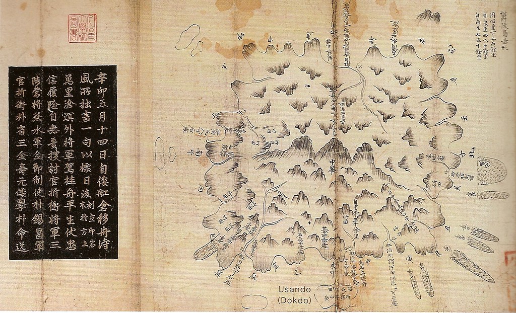
The Chinese characters written on Usando can be seen more clearly on the following closeup of the island. They translate as follows: "groves of haejang bamboo, the so-called Usando" (海長竹田 所謂 于山島).

In 1694, sixteen years before the above map was made, Jang Han-sang (張漢相) also inspected Ulleungdo. In his report, Inspector Jang wrote the following:
東方五里許 有一小島 不甚高大 海長竹叢生於一面Notice that Inspector Jang also wrote about a small island with haejang bamboo two kilometers off Ulleungdo's east shore. The small island was almost certainly the Usando on the 1711 map.
동쪽으로 5리 (2킬로) 쯤에 한 작은 섬이 있는데, 고대(高大)하지 않으며 해장죽 (海長竹)이 한쪽면에 무더기로 자라고 있다.
About five ri (2 km) to the east (of Ulleungdo) is one small island. It is not very big or very high, and it has a grove of haejang bamboo (海長竹) growing on one side.
About 2.2 kilometers off the east shore of present-day Ulleungdo is a small island called "Jukdo" (竹島), which still has groves of tall bamboo growing on it. The Usando on Inspector Bak's 1711 map and the small island mentioned in Inspector Jang's 1694 report were obviously not referring to "Dokdo" (Liancourt Rocks). Instead, they were almost certainly referring to Ulleungdo's present-day neighboring island of Jukdo. (Go HERE to read more about the 1694 inspection.)
The 1711 inspection occurred after the An Yong-bok incident, which means that An Yong-bok's "Usando" ended up being Ulleungdo's neighboring island of Jukdo (竹島), not Liancourt Rocks (Dokdo).
On the left side of the 1711 map is written the following:
辛卯五月十四日自倭舡倉移舟待風所拙書 一句以標日後(刻立卯岩木於方上)萬里滄溟外將軍駕桂舟平生伏忠信履險自無漫搜討官折衡將軍三陟營將兼水軍僉節制使朴錫昌軍官折衡朴省三金壽元倭學朴命逸It seems that the above verse may have been what was written on one of the sign posts that are indicated on many old maps of Ulleungdo.
----------------
On March 14 in the "shin myo" year (辛卯 - 1711), we moved the boat from the Japanese boat house (倭舡倉) to the "wind-waiting place" (待風所). A verse was written and made into a sign for posterity (拙書一句以標日後). It was craved in wood and erected on a rock facing east (刻立卯岩木於方上):
On the distance blue sea, the general sails on a cinnamon tree ship. He has been loyal and faithful all his life, so even if there is hardship, there is no need to worry.Inspector: Jeochung General (折衡將軍), Samcheok Camp Commander (三陟營將) & Navy Cheomjeoljesa (水軍僉節制使) Bak Seok-chang (朴錫昌)
Military Civil Servants (軍官): Bak Seong-sam (朴省三), Kim Su-won (金壽元)
Japanese Interpreter (倭學): Bak Myeong-il (朴命逸)
Gerry, I think the map is a combination of documents and inspections but there some problems here, for sure.
ReplyDeleteFirst the phantom five islands exist on this map showing it is highly unlikely this map is based purely on an on site inspection.
Second is the position of Usando. If Usando is Jukdo Islet on this map then why is it located so far South of what appears to be Jeang Am and Jang Gun Am? It would be impossible to make such a huge error based on a survey. Jukdo Islet is at least 2kms north of these rocks.
See the difference of Jukdo's position relative to these towering rocks on other maps.
Jukdo Position1
Jukdo Position2
Jukdo Position3
Maps of Ulleungdo that are based on actual survey consistently show Jukdo between Three Angels Rocks and the two towering rocks to the South. It seems the map you post shows a big difference in accuracy between Ulleungdo Island’s interior-coast and the surrounding islands. This leads us to believe the map is not entirely a map drawn solely on an on-site inspection.
We also must ask ourselves, why do these early maps say "The So-Called Usando? Why not just "Usando"?
All of these maps point to one conclusion. Korea lost contact with the Ulleungdo region after the vacant island policy was established and the Imjin wars disrupted Chosun activities in the region.
Making a definite judgement on ancient Usando on these maps will never be a slam dunk as they say...
Steve Barber,
ReplyDeleteYou have to change your thought basically - not always maps are drawn in the western style, that means not always upper side is north.
Look at the map closely. There are words "辰" (at left side) and "寅" (at right side).
辰 means east-southeast, and 寅 means east-north east. And the small island can be seen just inbetween 辰 and 寅, which means the island located at almost east side, not south side.
Jukdo is at almost the same direction - east side.
Pacifist, regardless of the direction of "Usando" the point is it cannot be said to be Jukdo Islet when you consider its location relative to Ulleungdo's other prominent rock formations.
ReplyDeleteCheck Leegyuwon's map and the others and note Jukdo's location relative to these other huge rock towers. Others who mapped this region on surveys got it right. Gerry's map didn't.
Other maps based we can verify that were drawn on actual trips to Ulleungdo don't show the "phantom five"
Check the Japanese maps. Jukdo is always between Three Angels rock and the two towers.
Steve,
ReplyDeleteI do not know what those five islands were referring to, but there are several rocks on the southern half of Ulleungdo, too. They could have been referring to some of those. You can see the rocks on this detailed 1917 Map of Ulleungdo. If that link does not work, go HERE and choose 鬱陵島.
I am not sure what you are talking about in regard to the position of Usando since the map does show it just off Ulleungdo's east shore, but as for Jang-am, it could be one of those five islands.
We know that Bak Seok-chang did inspect Ulleungdo not only because of the map, but also because he left markers, including the engraved rock that is shown in THIS PICTURE.
I think the reason it was labeled, "the so-called Usando," is that the location of the island was in question because of An Yong-bok's confusing testimony, and the 1711 inspector wanted to point out that it was the island in question.
What the map confirms is that Usando was not "Dokdo" in 1711 or on any of the Korean or Japanese maps of Korea. That is what I call a slam dunk, and that is why you and other Dokdo advocates are forced to come up with silly theories, not about whether Japan incorporated Liancourt Rocks in 1905, but about her motives for incorporating the Rocks. The motives? I consider that kind of theorizing an act of desperation that is used when you have little or nothing else to support your claim.
Gerry, you didn't answer my question. Can you not see the position of this "Usando" relative to Three Angels Rock and the other two towering rocks shown on this map? Jang Am is one of those two, the other is Jang Geun Am. Both are South of Jukdo not North.
ReplyDeleteAgain, compare it to other maps and you will definitely see the position would indicate this Usando could not be Jukdo when you consider the other rocks. Also compare this map to others. It then becomes apparent this map is not based on a survey but second-hand information. It is also a dead give away when these five islands to the South are added.
This error could be dismissed if on its own however, if you look at other maps of Ulleungdo drawn by both Japanese and Korean, shown above. These maps consistently show Jukdo Islet between Three Angels and the two towers. Please check the maps above again.
The 1711 map is part survey (interior) and part copy (surrounding islands)
Gerry, you are a legend in your own backyard.
Unfortunately outside of your blog it's a far different world and you are held to a different standard. You are not judge and jury. (thank God...)
Steve,
ReplyDeleteYou may not have liked my answer, but I did answer your question.
If you do not think the Usando on the map is Jukdo, then what island do you think it is? Gwaneumdo? Dokdo?
As far as I know, you are the first person to suggest that Bak Chang-seok did not survey Ulleungdo and that he drew his map from hearsay. If that is true, then how do you explain the rock that was found on Ulleungdo with his inscription on it? And what map would he have copied from? Isn't his the most detailed map of Ulleungdo up to that date?
I cannot see the two Japanese maps right now, but the only other Korean map you are comparing it to is Lee Gyu-won's 1882 map. However, if you look at THIS MAP, you will notice that there are no "two towers" on it, either. However, it does show a peak or rock on the southeast corner of Ulleungdo. And if you look at the 1711 map, you should notice that it shows a finger-like peak on the southeast corner of the island, as well.
I do not think anyone on my blog considers me a legend, and I am not a historian. I am just an English teacher with an interest in Korean history.
As for my reputation, all I can say is that I would rather have mine than yours.
Gerry, I didn't say the map was not based on a survey. I said the additional five islands and the inaccurate position of what you say is Jukdo (Usando) shows this map not to be accurately representative of Ulleungdo's surrounding islands.
ReplyDeleteOther maps show these five islands as well. This is clear evidence Chosun cartographers often copied maps and thus passed on these errors. The 1711 map could be a combination of both survey and previous maps but again the islands show it not to be a survey map.
Again, compare other accurate survey maps shwn above.
Gerry, I don't rush to judgement on these Ulleungdo maps. The map you posted before shows two Usandos? Just as Koreans can't definitely say this Usando is Dokdo how can anyone definitely conclude it is Jukdo?
Steve wrote: "It then becomes apparent this map is not based on a survey but second-hand information."
ReplyDeleteNow Steve writes: "Gerry, I didn't say the map was not based on a survey."
The 1711 map was an inspection map. It gives the names of the people in the inspection party, and on the back of the map, it says it was made by Bak Chang-seok, himself.
As I explained, there are rocks and islets on the southern part of Ulleungdo, which could account from those five islands. For example, there is "Sea Lion Rock" at the southern tip of Ulleungdo, which even Western maps show.
By the way, Steve, you did not answer my question. What island do you think the Usando on the map was?
Gerry, don't selectively chose quotes of mine. Read my first quote.
ReplyDeleteMy first quote. "First the phantom five islands exist on this map showing it is highly unlikely this map is based purely on an on site inspection. Note "purely"
My second quote "The 1711 map is part survey (interior) and part copy (surrounding islands).."
My third quote "The 1711 map could be a combination of both survey and previous maps but again the islands show it not to be a survey map.
Do you want me to say it again? O.K. The maps shows a disparity in accuracy between the interior of the island and shore compared to the position of surrounding islets. I came to this conclusion on my own and it seems the Korean historical society you seem to loathe so much did much the same.
Look at the size of these islands to the south Gerry, they are huge and supposedly far off shore from Ulleungdo. They are not drawn as small rocks and most importantly they don't exist. In fact, these islands are shown as the size as "Usando" On top of that, these islands are drawn on other maps you consistently cite for reference.
Aside from the phantom five, you have yet to explain why Usando (Jukdo?) would be located far to the South of such prominent rock formations. This is despite the fact all other Japanese and Korean maps (even very crude) consistently show Jukdo to be between Three Angles rock and the twin towers to their South.
Gerry, I honestly don't know what some of these maps represent. What I do know is many are incorrect copies. Some of these maps with scale show huge errors in distance. These are maps you have wrongfully cited for the distance between "Jukdo" and Ulleungdo. This dispite the fact Ulleungdo is shown to be almost 40kms across when it is really only around 10kms.
Usando historical references have to made on a case by case basis. I'm not going to cite such ambiguous, ass backward maps that show such glaring errors and attempt to make a bold decision such as you and your lobbyists have done.
However, if you want to put your head in a noose for the mayor of Shimane Prefecture knock yerself out Gerry.