竹島問題の歴史

30.12.07

1861年 - 金正浩「大東輿地圖」

Gerryの投稿の日本語訳です。原文はこちら↓(English)
1861 - Daedong Yeojido (大東輿地圖) - Ulleungdo

下に挙げたのは、金正浩「大東輿地図」(1861)に収録された鬱陵島の木版印刷地図です。この地図で興味深いのは、于山島が描かれていないことです。同じ製作者の靑邱圖」(1834)の鬱陵島図には描かれているのに、です。

1861 金正浩「大東輿地図」鬱陵島図 国会図書館版_1

次の地図は、上の金正浩「大東輿地図」(1861)の鬱陵島図を元に作成されたと見られるものですが、鬱陵島に関する情報と共に、于山島が書き加えられている事にお気づきでしょうか。金正浩が1861年の「大東輿地図」を1864年になって改定したとすれば、地図はその改訂版の写しになるのでしょう。
1861 金正浩「大東輿地図」鬱陵島図 国会図書館版_2

この地図の上部に書かれた文章は1834年の「靑邱圖」にも書かれています。

英宗十一年 江原監司趙最壽啓言 盃(鬱)陵島地廣土沃有人居田他而其西又有于山島 亦廣闊云則所謂西字與此各之在東相佐

英宗十一年(1735)江原道監司の趙最壽は国王への報告の際に「鬱陵島は土地が広く肥沃で住居や畑があります。その西の方に于山島があり、これもまた広く開けています。」と語っているが、いわゆる「西」の字は、(于山島が)この地図で東に位置しているのとは異なっている。

上の地図はLee Sang-tae氏の著作、「Historical Evidence of Korean Sovereignty over DOKDO」からの引用です。于山と記された島の下に、ご本人が "Usando (Dokdo)"と書き加えてあります。つまり、彼はこの隣接島が"独島" (竹島/Liancourt Rocks)であると主張しているわけです。しかしながらこの地図は、于山島を一つの島からなる島として描いており、この事からも于山島が"独島" (Liancourt Rocks)ではないことが分かります。"独島" (Liancourt Rocks)は鬱陵島の南東92kmに位置する、主な2つの島からなる島だからです。一つの島ではないのです。これは韓国の学者が盲目的に証拠を無視し、"于山島"が"独島" (Liancourt Rocks)の古名であると主張する、いつものパターンなのです。しかしながら、この地図が示しているように、これも又、于山島が鬱陵島の隣接島に過ぎない事を示しているのです。

(訳者注:地図中の注の現代語訳はYabutarouさんによるものです。)

29.12.07

Korean Nationalism and so-called "Dokdo"

As some of the readers may have noticed, Korean keep commenting on last month's specific post by Pacifist and leaves many unrelated nationalistic comments. I don't understand why they don't even read what it is written or comment on what it is written, instead chanting " It's ours !" "Japan colonized us !". It looks like a religious cult to me. What's going on in Korean educational system? I hope next Korean government stops brainwashing their own kids and train them to be able to debate logically based on facts and evidences.

I found a funny video about recent incident of driver's licence manual in Oregon, U.S. I highly recommend Korean to stop those eccentric acts around the world. It makes not only Korean but whole Asian looks stupid.


Korean news about this video.

1699 - Today's Kwannundo(観音島) and Small Udo(小于島) in 「欝陵島図形」 by Choson Official Inspector, the Identical Figures.

I found the excellent work by our frequent commentator GTOMR over at Enjoy Korea BBS last week. He compared the figures of today's Kwannundo in modern Naver and Small Udomap in 1699 「欝陵島図形」 by Choson Official Inspector. Honestly, I was quite surprised to see those, since they are almost identical.

From his superb work, it is now safe for us to determine that those two are the same island, today's Kwannundo(観音島). The shapes of today's Jukdo in Naver map and Big Udo(大于島) are also similar enough to say they are the same island(竹嶼 or 竹島 in Korean), too. It is now clear that Choson officials knew the existance of Kwanundo and the fact that so-called Usando is today's Jukdo. And they mapped it with accurate shapes and location on the official report. Yabutarou's work is also worth to check.

20071223 小于島とNaver地図 20071223 大于島とNaver地図
20071223 Naver Mapで鬱陵島の北東部を見てみる。 1699 「欝陵島図形」
(Huge thanks to GTOMR for permitting me to use his work.)
GTOMR wrote a excellent summery titled "10 reasons why Usando is not Takeshima/Dokdo", too (Korean)

1800年代以前(推定) - 東京山川 八道地圖

Gerryの投稿の日本語訳です。原文はこちら↓(English)
Donggyeong San Cheon (東京山川) - Paldo Jido (八道地圖)

以下に挙げたのは、「東京山川 八道地圖」の朝鮮半島と江原道の図です。地図帖の作成年代は不明ですが、1800年代以前の辺りであると考えられています。韓国の高麗大学図書館の所蔵です。(地図へのリンク)

朝鮮半島図には、 "于山"と書かれた小さな附属島がある鬱陵島が東海岸に描かれています。韓国側はこの"于山島"が竹島/Liancourt Rocks/独島の古名だと主張しますが、他の多くの地図同様、この地図も、于山島は"独島"などではなく鬱陵島の隣接島であるに過ぎない事をあらわしています。この事実は、同じ地図帖の中の江原道図からも証明できます。

江原道図 (リンク) には、鬱陵島の拡大図があり、すぐ東海岸に"于山島" と書かれた島が描かれています。この地図の于山島が"独島"などではありえないことは明白です。というのも"独島"は鬱陵島の東南92kmにあり、基本的に二つの島嶼からなる島だからです。この地図に描かれているような、単独の島ではないのです。この地図では5つの小さな島が南海岸に描かれており、このことは韓国の鬱陵島の古地図に共通する特徴であると言えます。

鬱陵島の下の文から、島の大きさ(東西80里、南北50里)、動植物が分かります。また、朝鮮半島の蔚珍から船で二日かかることも分かります。
1800年代以前(推定) - 東京山川 八道地圖_2 1800年代以前(推定) - 東京山川 八道地圖_4

27.12.07

Geographical Survey Institute of Japan(国土地理院) first displays Takeshima's details in the topographical map.

(This is a translation of San-in Chuo Shinpo article on 12th December、2007.)

(Original by San-in Chuo Shinpo : 原文)
国土地理院が地形図に竹島の詳細を初表示 (山陰中央新報)http://www.sanin-chuo.co.jp/news/modules/news/article.php?storyid=446064006
(Korean News : 韓国のニュース)http://news.joins.com/article/aid/2007/12/16/3032497.html

(Takeshima, which consists of an east and a west island has now been drawn on detailed Japanese topographical map. The characters "隠岐の島町" (Okinoshima Town) indicate possession.

The Geographical Survey Institute of the Ministry of Land, Infrastructure, and Transport published, for the first time, the topographical map of Takeshima (South Korea: Tokdo) with a scale of 1/25,000, which shows the details of the islets. Both Japan and Korea claim ownership of the islets.

The map was made using a space satellite image, which shows Takeshima more clearly than past maps. Previous maps only showed outlines of the islets since detailed investigations could not be made. The map shows not only Japanese territory, but also the geographical features of the territory.

The need for an updated topographical map was especially felt when the new Oki Airport was opened in July 2006. In addition, to the Okinoshima town's in giving birth by the amalgamation in October, 2004, and having become this town belonging, Geographical Survey Institute reformed after an interval of nine years. Takeshima formerly belonged to Gokasho village(五箇所村), Shimane Prefecture.

It is a topographical map of this town that divides into five pieces that Takeshima who consists of the two island in east and west appears. Among these, the east island (Higashijima : 東島) of the altitude 97 meters and west island (Nishijima : 西島) of 168 meters were published while having shown the Nishimura(西村) district.

Takeshima was impossible to be mapped in detail due to the illegal occupancy of South Korea, since the topographical map of 1/25,000 was usually made based on the photograph and the field investigation. However, it was decided to be possible to supplement because the prospect had looked up in the topographic survey that used the space satellite image.

The PR room of the insititute announced that "It is an obligation of Geographical Survey Institute to arrange Japanese territory on the map. At last, Takeshima's details were able to be displayed though the field investigation etc. were not able to have been done."

To use it to enlighten the Takeshima problem, Shimane Prefecture exhibits this topographical map in the Takeshima Reference room that installed it in old prefectural museum in the Matsue City town

(Huge thanks to pacifist for checking my translation.)

21.12.07

1840~1860年頃 隠岐国松島


江戸時代後期の学者、文鳳堂こと山城屋忠兵衛の編纂した「文鳳堂雑纂」は幕末(おそらく1840~1860年頃か)の編と思われますが、この中に竹島(欝陵島)について触れている項があり、その説明文の中で松島(リアンクール岩、現在の竹島)について言及しています。興味深いことに、ここでは隠岐国の松島と記載されており、江戸時代後期でも松島(リアンクール岩)は隠岐に所属する島と認識されていたことがわかります。

(欝陵島の地図はこの本に収録されたものです)


隠岐国松島ノ西嶋*ヨリ海上道●(規:左が矢)凡ソ四十里許リ北方ニ一島アリ名テ竹島ト云フ 此ノ島日本ニ接シ朝鮮ニ隣シ地形三角ニシテ周囲凡ソ十五里許リ

(*松島ノ一小属島ナリ 土俗呼テ次島=ツキノシマト做ス)

現代語訳:


隠岐の国の松島の西島*から海上およそ40里ほどの北方に一つの島があり、その名を竹島と言う。この島は日本に接しており、朝鮮にも隣している。島の形は三角形で周囲はおよそ15里ほどである。

(*松島に属する小さな島である。地方の人々は次島、「つぎのしま」と呼んでいる)

ca 1840-1860 Matsushima of Oki County


To follow is from the book 文鳳堂雑纂 (Compilation of various things by Bun-ho-do) by Bun-ho-do (文鳳堂) aka Yamashiroya Chubei (山城屋忠兵衛), who was a scholar in the late Edo period. The exact published date is unknown but it may have been mid to late 19th century - perhaps 1840-1860.


In the chapter of Takeshima (Ulleungdo), he referred to Matsushima (Liancourt rocks) as Oki county's Matsushima. This is another evidence to show that Japanese in the Edo period believed that Matsushima (Liancourt rocks) was a part of Oki county.

(The map of Ulleungdo is from this book.)


There is an island at 40-ri north from Nisji-jima *
(western island) of Oki county's Matsushima
, which is called Takeshima. This
island is close to Japan and is next to Chosun, and its shape is triangular with
the circumference about 15-ri.

(*Nishi-jima: a small islet which belongs to Matsushima. People in this area usually call it as "Tsugi-no-shima", the next island.)

13.12.07

1954年 ヴァン・フリート使節団報告書


極東へ赴いたヴァン・フリート使節団の報告書は、米国の特別使節大使の任に着いたジェームズ・ヴァン・フリートの手による秘密報告書です。韓国、日本、台湾、フィリピンを視察した後に書かれ、1954年に第34代米国大統領ドゥワイト・アイゼンハワー大統領の元に送られました。


次の文章はその秘密報告書からのものです:


独島という島(またはリアンクールや竹島とも呼ばれる)は韓国と日本の本州のほぼ中間地点の日本海にある。(東経131度80分、北緯36度20分)この島は実は、無人で不毛の岩の集まりに過ぎない。日本との講和条約の草案が作られた時、大韓民国が独島の領有権を主張したが、米国はこの島は日本の主権下に残るものと結論した。そしてこの島は講和条約下で日本が所有権を放棄した島々には含まれなかった。大韓民国にはこの島に関する米国の立場を秘密裏に伝えたが、米国の立場は公には発表されなかった。米国はこの島は日本領だと考えているが、紛争に干渉することはこれまで断ってきた。米国の立場は紛争は適切に国際司法裁判所(ICJ)に委ねるのが良いとするもので、このことは非公式に大韓民国に伝えられた。

ヴァン・フリート将軍の見解をまとめると次のようになります:
海洋上の一方的な領有権の宣言(李承晩ライン)は違法である。
米国はリアンクール岩(竹島)は日本の領土だと結論づけた。
この島をめぐる紛争は国際司法裁判所に委ねるべきだ。


サンフランシスコ講和条約*に書かれた様に、リアンクール岩(竹島・独島)は日本が韓国に返還する島々のリストには含まれませんでした。


*Japan recognizing the independence of Korea, renounces all right, title and claim to Korea, including the islands of Quelpart, Port Hamilton and Dagelet.


米国はリアンクール岩(竹島・独島)は日本領であり、国際司法裁判所に委ねるよう勧めました。日本もそれ以来韓国に過去2回にわたり国際司法裁判所行きを提案していますが、韓国は拒否し続けています。


For English text, please look at:


1954 Report of Van Fleet mission to the Far East


The Report of Van Fleet Mission to the Far East is a secret report drafted by James Van Fleet, a US special mission ambassador, after a round of visits to South Korea, Japan, Taiwan, and the Philippines, and sent to the 34th U.S. President Dwight Eisenhower in 1954.


To follow is from the report:


The Island of Dokto (otherwise called Liancourt and Take
Shima) is in the Sea of Japan approximately midway between Korea and Honshu
(131.80E, 36.20N). This Island is, in fact, only a group of barren, uninhabited
rocks. When the Treaty of Peace with Japan was being drafted, the Republic of
Korea asserted its claims to Dokto but the United States concluded that they
remained under Japanese sovereignty
and the Island was not included among the
Islands that Japan released from its ownership
under the Peace Treaty. The
Republic of Korea has been confidentially informed of the United States position
regarding the islands but our position has not been made public. Though the
United States considers that the islands are Japanese territory
, we have
declined to interfere in the dispute. Our position has been that the dispute
might properly be referred to the International Court of Justice
and this
suggestion has been informally conveyed to the Republic of Korea.

General Van Fleet's view is as follows:

Unilateral proclamation of sovereignty over the seas (Syngman Rhee line) is illegal.
The United States had concluded Japanese sovereignty over the rocks.
The dispute over the rocks might properly be referred to the International Court of Justice.


As the San Francisco Peace Treaty* shows, Liancourt rocks (Takeshima/Dokdo) were not included in the list of islands which Japan should give back to Korea.


*Japan recognizing the independence of Korea, renounces all right, title and claim to Korea, including the islands of Quelpart, Port Hamilton and Dagelet.


USA meant that Liancourt rocks (Takeshima/Dokdo) are Japanese territory and recommend to go to the International Court of Justice - Japan proposed Korea to go to ICJ twice since then but they kept rejecting the proposal.

1950年 オーストラリア政府の質問に対する米国の回答

以下にご紹介するのはサンフランシスコ講和条約に関してオーストラリア政府の質問にアメリカが答えた文書からのものです。この文書を見ても、アメリカが当時から竹島(リアンクール岩)を日本所属の島と認めていたことが分かります。

米国極東アジア事務局のロバート・A・フィアリー氏のメモ(日付なし)より。(『オーストラリア政府からの質問状に対する回答』より)

As to the English text, please see: http://dokdo-or-takeshima.blogspot.com/2007/12/1950-usa-answers-to-australian.html

内海の島々、隠岐列島、佐渡、奥尻、礼文、利尻、対馬、竹島、五島列島、琉球北部、伊豆諸島、などの永く日本領と認識されていた島々は日本が保持することになるであろうと考えられている。琉球中央部および琉球南部、小笠原諸島(西之島、火山列島、Parece
Vera、南鳥島を含む)は米国を管理機関とする国連の信託統治支配下に置かれることになろう。琉球の人口がかなり多いこと、戦略的信託統治がソビエト連邦の拒否権にあうことがほぼ確実であることなどから、米国はこれらの島々について通常の信託統治を求めることになろう。日本は信託統治のシステムをかつての日本の委任統治の島々まで拡大して国連安全会議の1947年4月12日の決議を受け入れるであろう。この条約には、1947年に中国が正式に統治権を再確認したプラタス・リーフおよび島嶼やこれまでフランスと中国が紛争を継続してきたパラセル諸島やスプラトリー島については含まれないであろう。スプラトリー島については日本も戦前に領有権を主張したが、この無人島についての要求は条約内で正式に保証するほど重要なものではないと思われる。日本政府はこれまでかつて南極の領土を要求したことはない。条約の中で、日本の南極探検隊を根拠に領土を要求することを放棄すると銘記すべきとは考えられていない。


1950 USA answers to Australian government


To follow is from the USA answers to Australian government concerning the SF Peace Treaty. It is apparent that USA thought that Liancourt rocks (Takeshima) belongs to Japan.


Undated Memorandum by Mr. Robert A. Fearey of the Office of Northeast Asian Affairs. (From "Answers to Questions submitted by the Australian government")
1950.


It is thought that the islands of the Inland Sea, Oki
Retto, Sado, Okujiri, Rebun, Riishiri (sic), Tsushima,
Takeshima, the Goto Archipelago, the northern most Ryukyus,
and the Izus,
all long recognised as Japanese
, would
be retained by Japan. The central and southern Ryukyus, the Bonins, including
Rosario Island, the Volacanos, Parece Vera and Marcus would be placed under the
trsuteeship system of the United Nations with the United States as the
administering authority. Because of the considerable population of the Ryukyus
and and the virtual certainty that that strategic trusteeship would be veoted by
the Soviet Union, the United States would seek ordinary trusteeship for these
islands. Japan would accept the United Nations Security Council action of
April2, 1947 extending the trusteeship system to the former Japanese Mandated
Islands. The treaty would contain no reference to Pratas Reef and Island, over
which China formally reasserted sovereignity in 1947 or to the Paracel Islands
or Spratly Island, title to which has been disputed between France and China.
While Japan also claimed Spratly Island before the war its claim to this
uninhabited spot is not believed important enough to warrant mention in the
treaty. The Japanese government never claimed any territories in the Antarctic.
It is not considered that Japan should be required in the treaty to renounce
claims on behalf of Japan made by Japanese Antarctic expeditions.

10.12.07

1953 Jul 22 - US Doc. Reconfirms Dean Rusk Letter

In an August 9, 1951 letter to the Korean Ambassador, US Secretary of State Dean Rusk wrote the following:
"As regards the island of Dokdo, otherwise known as Takeshima or Liancourt Rocks, this normally uninhabited rock formation was according to our information never treated as part of Korea and, since about 1905, has been under the jurisdiciton of the Oki Islands Branch of Shimane Prefecture of Japan. The island does not appear ever before to have been claimed by Korea...."
Some Koreans and Dokdo advocates claim that the US government changed her mind on the status of Liancourt Rocks with the signing of the 1952 treaty between Japan and the US, but the following 1953 letter reconfirms that the US government still considered Liancourt Rocks to be Japanese even after the signing of the treaty. The 1954 Van Fleet report, HERE, also reconfirmed the US position. (For a Japanese explanation of the letter below, see HERE)

1953 Jul 22 - Methods of Resolving LIancourt Rocks Dispute 1

1953 Jul 22 - Methods of Resolving LIancourt Rocks Dispute 2

August 9, 1951 Dean Rusk Letter to Korean Ambassador

1951Aug9 - Dean Rusk Ltr 1
1951Aug9 - Dean Rusk Ltr 2
1951Aug9 - Dean Rusk Ltr 3
1951Aug9 - Dean Rusk Ltr 4

Korea's NE Asian History Foundation Advertisement

I opened my Yahoo! Mail today and noticed an advertisement for Korea's Northeast Asian History Foundation in the sidebar. The ad is using a history quiz contest to get new members for the foundation's Web site. You need to be a member to take the quiz. See HERE.

The categories of the quiz are as follows:
  • History Book Distortion
  • East Sea
  • Dokdo
  • Yasukuni Shine
  • Comfort Women
  • Baekdu Mountain
  • Northeast "Gongjeong" (I do not know what "Gongjeong" means in this case.)

Does that look like a history quiz or a propaganda quiz? Anyway, it seemed a little strange to me that a "history" foundation would be advertising for members like that.

9.12.07

Donggyeong San Cheon (東京山川) - Paldo Jido (八道地圖)

Below are maps of the Korean peninsula and Gangwon Province from the atlas "Donggyeong San Cheon: Paldo Jido" (東京山川 八道地圖). The date of the atlas and maps are unknown, but they were most likely made sometime before the 1800s. The atlas is stored in Korea's Koryo University Library. (Link to Korean Map)

The map of the Korean peninsula shows Ulleungdo (鬱陵島) off the east coast with a small neighboring isand labeled "于山" (Usan). Korea claims that the "island of Usan" (于山島) was the old Korean name for "Dokdo" (Liancourt Rocks), but this map, like many others, shows that Usando was a neighboring island of Ulleungdo, not Dokdo (獨島). This is confirmed by the Gangwondo (江原道) map that was included in the same atlas.

The Gangwondo map (LINK) shows a close-up of Ulleungdo with an island just off its east shore labeled "于山島" (Usando). We know that the Usando on this map was not "Dokdo" because Dokdo is ninety-two kilometers southeast of Ulleungdo and is essentially made up of two islets, not one. The maps also shows Ulleungdo with five other small islands just off its southern shore, which was a common feature of Korea's old Ulleungdo maps.

The writing below Ulleungdo gives the dimensions of the island (80 ri east to west & 50 ri north to south) and the flora and fauna found there. It also says that Ulleungdo was two days away by boat from Uljin (蔚珍), which is a place on the Korean peninsula.

Donggyeong San-cheon - Koreal

Donggyeong San-cheon - Ulleungdo

Donggyeong Sancheon - Gangwondo full

Donggyeon San-cheon - Ulleungdo 2

Donggyeong San-cheon - Ulleungdo 2

1905年1月28日 閣議決定資料

以下は公文類集第29編から1905年の竹島編入の閣議決定の資料です。

口語訳です:


明治38年1月28日

別紙の内務大臣の無人島所属に関する件の請願提案(請議)を審査したが、(この提案の内容は)この北緯37度9分30秒、東経131度55分、隠岐島から西北85海里のところにある無人島はこれまで他国が占領したと認めるべき形跡がなく、一昨年(明治36年、1903年)日本の中井養三郎という者が漁舎を建て、人夫を移して、漁具を備えてアシカ猟に着手し、今回領土編入並びに貸下げを出願したので、この際所属と島名を決める必要があり、この島を竹島と名づけ、これから島根県所属の隠岐司の所管にするということにある。審査したところ、明治36年(1903年)以来、中井養三郎という者がこの島に移住し漁業に従事したことは関係書類から明らかであり、国際法上占領の事実があると認め、これを日本の所属とし島根県所属の隠岐島司の所管として差し支えないと考えられた。よって、提案の通りに閣議決定してよいものと認める。

原文です:


明治38年1月28日

別紙、内務大臣請議無人島所属に関する件を審査するに、右は北緯三十七度九分三十秒、東経百三十一度五十五分、隠岐島を距る西北八十五浬に在る無人島は、
他国に於て之を占領したりと認むべき形跡無く、一昨三十六年、本邦人中井養三郎なる者に於て漁舎を構え人夫を移し、漁具を備えて海驢猟に着手し、今回領土編入並に貸下を出願せし所、此際所属及び島名を確定するの必要あるを以て該島を竹島と名け、自今、島根県所属隠岐司の所管と為さんとすと謂ふに在り。依て審査するに、明治三十六年以来、中井養三郎なる者該島に移住し漁業に従事せることは、関係書類に依り明なる所なれば国際法上占領の事実あるものと認め、之を本邦所属とし、島根県所属隠岐島司の所管と為し差支無之儀と思考す。依て請議の通り、閣議決定相成可然と認む


(お願い:明治時代の古文にお詳しい方、訳におかしな点があればご指摘をお願いします。)

The translated text in English is here:
http://dokdo-or-takeshima.blogspot.com/2007/11/28th-of-january-1905-dicision-by.html

7.12.07

1861 - Daedong Yeojido (大東輿地圖) - Ulleungdo

Below is a is a wood-block printed map of Ulleungdo (鬱陵島) from the "Daedong Yeojido" (大東輿地島) atlas, which was made by Kim Jeong-ho (金正浩) in 1861. The interesting thing about the map is that it does not show the neighboring island of Usan (于山島), even though the island was included on Mr. Kim's 1834 "Cheonggudo" (靑邱圖) map of Ulleungdo.

1861 - Daedong Yeojido - Ulleungdo

Below is another map of Ulleungdo, which looks to be a copy of Kim Jeong-ho's 1861 "Daedong Yeojido" Ulleungdo map shown above, but notice that Usando is added to the map below, as well as other information about Ulleungdo. Supposedly, Mr. Kim revised parts of his 1861 "Daedong Yeojido" map in 1864, so the map below is probably a copy of that revised version.

2nd half of 19th C - Daedong Yeojido

The writing in the uppper part of the map was also written on Kim Jeong-ho's 1834 "Cheonggudo" map and translates as follows:

In the 11th year of Yeongjo (1735), Gangwon Provincial Governor Jo Choi-su reported to the king, ‘A survey of Ulleungdo has found that the land is wide and fertile, and there are signs that people have lived there. Also, to its west is Usando, which is also wide and spacious.’ The so-called “west” character is different on this map, where (Usando) is to the east.
The above map is from Lee Sang-tae's book, "Historical Evidence of Korean Sovereignty over DOKDO. Notice that below the neighboring island labeled as "于山" (Usan), Professor Lee typed "Usando (Dokdo)," which means he is claiming that the neighboring island is "Dokdo" (Liancourt Rocks). The map, however, shows Usando as "one" island right next to Ulleungdo, which means the Usando on this map was not "Dokdo" since Dokdo is ninety-two kilometers southeast of Ulleungdo and is essentiallly made-up of two islets, not one. This is another example of a Korean scholar blindly ignoring the evidence to claim that "Usando" was an old Korean name for Dokdo (Liancourt Rocks); however, the above map shows, once again, that Usando was just a neighboring island of Ulleungdo, not Dokdo.

6.12.07

Mid 1700s - Haedong Chongdo (海東總圖) - Gangwondo

Below is a map of Gwangwon Province (江原道) from the "Haedong Chongdo" (海東總圖) atlas, which is believed to have been made sometime in the mid 1700s. The map and atlas are supposedly stored in the National Library of Korea.

The map clearly shows Usando (于山島) to the west of Ulleungdo (鬱陵島), which means that it could not have been "Dokdo" (Liancourt Rocks), as Korea claims, since Dokdo is ninety-two kilometers southeast of Ulleungdo. Nevertheless, in his book, "Historical Evidence of Korean Sovererignty over DOKDO," Lee Sang-tae (이상태) wrote the following about the map:

울릉도를 표시하고 그 서쪽에 우산도(독도)를 표기하여 두 섬이 우리 영토임을 분명히 아였다.

Here again, Usando (Dokdo) has been situated west of Ulleungdo, thus clearly indicating that the two islands belong to Korea.

Notice that Professor Lee again put "Dokdo" in parentheses next to Usando in spite of the fact that the Usando on this map could not have possibly been referring to Dokdo since Dokdo is east of Ulleungdo, not west. This is another example of how Korean scholars blindly ignore the evidence in their attempt to claim that Usando was the old Korean name for Dokdo.

Mid 1700s - Haedong Chongdo - Gangwondo 1

Mid 1700s - Haedong Chongdo - Gangwondo 2

1923年 島根県誌


以下の記述は島根県誌(1923年6月)に掲載された竹島(リアンクール岩、リャンコ島)についての興味深い読み物で、簡単な竹島の歴史が述べられています。
この文章には中井養三郎が明治政府にリャンコ島を日本に編入して欲しいとの請願を行った前後のいきさつが書かれていて、その点で貴重な資料です。

韓国の学者たちは日本軍が韓国併合の第一歩としてリアンクール岩(竹島・独島)を編入したのだと最近言い始めていますが、この文書を読むと編入の影にそのような邪悪な計画はなかったということが分かります。無主の島であり、無人島であった竹島(リアンクール岩)は、日本の実業家がこの岩島の利用法を思い立ち、その島を安全に開発したいと願ったために編入されたのです。


以下、口語訳です。

(原文をお読みになりたい方は写真をクリックしてご覧ください。)


第5章 竹島

隠岐の西北約85海里(155.1km)、石見の国の浜田から150海里(277.8km)、朝鮮の欝陵島から東南50海里(92.6km)のところにある。朝鮮では独島と書く。日本海にある小島で、朝鮮の欝陵島と共に日本海を東西に横断する海底山脈の上に位置し、その周囲の海は極めて深い。東西2つの主島とその周囲に並ぶ数個の小島とから成り、2つの島のうち一島は周囲15町(1635m)、高さ380尺(115.14m)でもう一つの島は周囲10町(1090m)、高さ226尺(68.478m)である。2つの島を合わせて周囲は約1里(4km)である。一本の狭い海峡(長さ180間=354.6m、巾5~60間=98.5~118.2m、水深5尋=7.6m)をはさんで2つの島が相対峙している。主島の周囲は奇観を呈する洞窟に富み、アザラシやアシカのすみかとなっている。島全体がほとんど不毛の禿岩の状態で、海風の為に樹木一本もなく、南面にだけわずかに雑草が生えているだけである。周囲全体が断崖のため登ることができない。海峡の両側に狭い平地の小石の浜が2~3箇所あるが、いずれも波を避けられない。そのため、船が停泊する場所がなく、さらに、航海する船の目標物として便利でありながら島には飲料水がない。周囲の小島もいずれも扁平で、上端をわずかに海面上に出しているだけである。

竹島は日本海の航路にあたり、1849年(嘉永2年)にフランス艦船リアンクール号による発見以来リアンクール岩の名前で呼ばれた。本県ではこれをリャンコ岩と俗称した。わが国では徳川時代に欝陵島を竹島、リャンコ岩を松島と呼んでいた。ところが明治時代になって、海軍水路部が編纂した水路誌で誤って欝陵島を松島と呼んでしまったため、元の松島つまりリャンコ岩を竹島と転じて呼ぶことになった。しかしながら、本県の海岸地方では今でも昔の名前のまま、欝陵島を竹島と呼ぶことがむしろ普通であり、このように竹島は同名異島の観を呈し、混乱を起こすもとになることがある。明治36年(1903年)に伯耆の国の中井養三郎がこの島(リャンコ岩)の漁獲を企画し、日章旗を建てた。翌37年(1904年)には各方面から競争して濫獲するようになり、種々の弊害が起きそうであった。この時点では中井はこの島を朝鮮の領土だと考え、上京し農商務省に話をして朝鮮政府に貸下げの請願をしようとした。偶々海軍水路部もリャンコ岩の所属を確かめようとして日韓両国からの距離を測定したところ、日本の方が10里(40km)近く、また日本人が島の経営を行っていることから、日本領に編入すべきものとした。そこで中井はリャンコ島の領土編入並びに貸下げ願いを内務、外務、農商務の三省に提出、三省は島根県庁の意見も聞き、閣議で領土編入を決定し、名前を竹島と命名し、隠岐島司の所管とした。


島根県告示第40号(明治38年2月22日)
北緯37度9分30秒、東経131度55分、隠岐から西北85海里にある島嶼を竹島と呼び、ただ今から本県所属の隠岐島司の所管と定める


明治38年(1905年)の日本海海戦の際にわが国の東郷艦隊がロシア艦アリヨール以下第2艦隊を追撃包囲して捕獲したのはこの島の南方18海里の海上であり、当時の戦報にリアンコート岩(リアンクール岩)の名前がしばしば報じられた為、この島は広く日本人に知られるようになった。
アザラシは毎年4~5月ごろから7月まで多く海上に遊泳し、6月ごろ子育てをするので、出漁者は欝陵島を根拠地として漁を行い、隠岐島西郷町にある中井氏経営による竹島漁猟合資会社が猟獲業を経営した。明治38年6月の創立という。

5.12.07

"Wayurok" (臥遊錄) - Ulleungdo (鬱陵島 - 울릉도)

The following is a description of Ulleungdo from the "Wayurok" (臥遊錄), which is a collection of travel logs that was made sometime during the Joseon Dynasty. I am just putting it up for reference, hoping that it gets translated over time. (Link to the Text)

鬱陵島
[주:新羅史曰于山國島名鬱陵]. 地誌
鬱陵或曰武陵. 亦曰羽陵登高望之. 三峰岌嶪, 撑空. 而南峰稍低. 日初出時. 風恬浪靜. 則衆峰攢靑. 岩壑呈露. 沙汀樹木. 歷歷可指. 新羅智證王. 聞于山國負險不服. 命伊湌異斯夫爲阿瑟羅州軍主(阿瑟羅江陵)往討之. 斯夫以爲于山愚頑負險. 難以力服. 易以計下. 乃多造木獅子. 分載戰艦誑之曰. 伱不急下. 當放此獸摶噬之. 國人恐懼來降. 及高麗太祖十三年. 島人使白吉土豆獻方物. 毅宗聞羽陵地肥廣可立州縣, 遣溟州道監倉金柔立往視. 回啓曰島中有大山從山頂向東行至海濱一萬三千餘步向南行一萬五千步向北行八千餘步有村落基址七所或有石佛鐵鍾石塔多生柴胡藁本石南草土多嵓石民不可
居遂寢厥後崔忠獻議以武陵土壤膏沃多珍木海錯遣使視之有村墟屋址宛然於是移東郡民實之使還多以海中珍怪之物來獻其後屢爲風濤所蕩覆舟人多物故乃還其民及我朝太宗大王時聞流民迯入者甚多命三陟人金麟兩爲按撫使刷出空其地麟兩言島中土地沃腴竹大如杠鼠大如猫桃核大於升凡物稱是云世宗大王二十年遣縣人南灝率數百人往搜逋民盡俘金九等七十餘人出來成宗大王二年有告別有三峰島者乃遣朴宗元往覔之因風濤不得泊而還同行一船泊羽陵島只取大竹大鰒魚以歸啓曰島中無人矣嘗遇一僧自稱壬辰之亂俘入日本丙午隨倭船至鬱陵島島
有大山三峰尤峻發島三面皆壁立萬仞南邊稍開豁然亂山若犬牙撑列水底舟道極險狹難入登岸則白沙平鋪長松列植山開望濶而江水流出緣江行十餘里則篔簹作藪不見天日大君梁柱小不减椽杠又穿藪行十餘里則有竹林其脩大若篔簹竹林旣窮而原野夷曠有村居墟落山多珍木藥草倭方伐竹採藥留渠守船鄰船適有同俘七人夜與相語天將曉發船以來日纔晡已到寧海地面云盖二島去此不甚遠一颿風可至于山島勢卑不因海氣極淸朗不登最高頂則不可見鬱陵稍峻風浪息則尋常可見麋鹿態獐往往越海出來朝日纔高三丈則島中黃雀群飛來接竹邊串[주:島中竹實特時漂出形如大慱暴海女拾之爲雜佩篔簹及竹亦或漂出一節有數尺者宜箭筒比多有之] 

蔚陵島說
鵝溪蔚陵島在東海之中距海濱不知其幾百里也每秋冬之交陰曀捲盡海氣澄朗則自嶺東望之如一后蒼烟撗抹於水天之間獨眞珠府與此島最爲相對故行人之登召公臺者或見其林木岡巒之狀了了然可辨以此知不甚遠也箕城人嘗言麋鹿蘆竹往往浮出於沙渚之間禽鳥之不知名者亦翩翩渡海而來及至海濱垂趐自墮爲光童所捕者數矣漁人舟子或凜到島傍見萊根蔬葉隨水出來而四面皆蒼岩鐵壁只有一洞門可捫蘿而入慮有防守者彷徨躅躑不敢近而回棹者有之居是島者未知爲何許人或疑其避役逃罪之輩自相婚嫁漸至繁盛或疑其獠蠻之種據有是島非自近始或疑其果有之

則豈無一番舟楫之往來豈無一物可交貨有無於他境乎疑者不一無所歸宿終置是島於茫昧恍惚無何有之鄕豈退之所謂桃源之說誠荒唐者歟噫仙神之說尙矣所謂蓬萊方丈瀛洲未知果眞有而崑崙玄圃見之者抑誰歟如使神仙不有則已有之則是島也妥知蓬萊崑崙之一而異人仙客之所在耶一幅布帆便風高掛則不過一晝夜之頃可以致身其間而世之羣疑衆惑從此可破旣不得此則令人徒費引領東望而空入於夢想吟咏之中悲夫  


1711 - 朴昌錫「鬱陵島圖形」

Gerryの投稿の日本語訳です。原文はこちら↓(English)
1711 - Bak Chang-seok's (朴昌錫) Map of Ulleungdo

下の地図は朴昌錫が1711年に行った鬱陵島検察の後に描いたとされる「鬱陵島圖形」です。韓国国際文化大学大学院Lee Sang-tae教授の「Hstorical Evidence of Korean Sovereighnty over Dokdo」 という書籍を写したものです。この地図はこの竹島論争において特に重要です。というのは、この地図は于山島を鬱陵島の東岸に隣接島として描いているだけではなく、"海長竹田(海長竹の竹林)"がある、と記述しているからです。この海長竹とは、7メートルにも成長する種類の竹で、しかも竹島/Liancourt Rocksは竹林が成長できる土壌のない島ですから、地図に描かれた于山島が"独島(竹島/Liancourt Rocks)"である可能性をこの地図は全否定するのです。

2086429772_c59068652f

地図が于山島を鬱陵島のすぐ東の沖に竹林を持つ単独の島として描いているのにも関わらず、この本の著者であるLee Sang-tae教授は、地図の于山島のすぐ横に"独島"と書きこんでいます。これは、韓国の学者が"独島"のことになると如何に盲目になってしまうか、のよい例です。独島/竹島/Liancourt Rocksはそもそも二つの大きな不毛な岩で構成される鬱陵島から92km南東にある島なのです。

拡大図で漢字(「海長竹田 所謂 于山島」)がよく読めます。

2086429828_6bf4e03b8d_o

1694年、この地図が作成される16年前に張漢相が鬱陵島を検察しています。その報告書の中で、彼はこう書きました。

(鬱陵島の)東約2kmの処に小さな島がある。それは大きくも高くもなく、海長竹が一面に生えている。

(原文)
東方五里許 有一小島 不甚高大 海長竹叢生於一面

検察使の張漢相も、鬱陵島東2km沖に小さな島があることを書いています。この小さな島はほぼ確実に1711年の地図の于山島だと考えられます。

現在の鬱陵島の東沖約2.2kmの所に、竹嶼(韓国名 竹島)があり、そこにはいまだに背の高い竹が生えています。1711年の朴昌錫の地図の于山島と1694年の張漢相の報告にある小さな島は、明らかに"独島"を指していません。その代わり、ほぼ確実に現在の鬱陵島の隣接島である竹嶼を指していることは間違いありません。(1711年の検察報告についてはこちらを参照→1711年 鬱稜島に派遣された検察官朴昌錫の残した碑文

1711年の検察は安龍福の事件の後に行われました。つまり、安のいう于山島とは、結局鬱陵島の隣接島である竹嶼であり、竹島/Liancourt Rocks/独島では無いということになります。

1711年の地図の左側には次のような文章が載っています。

辛卯(1711)の年の5月14日、倭船倉(日本人の船倉庫)から待風所へ向かった。後代の為の指標として一句読まれ、木に刻まれ、東に向かう岩の上に建立された。

青々とした遥かなる海を将軍は桂舟で渡ってきた。生涯忠誠心を持った人物であり、困難であっても憂えることは無い。
捜討官:折衡將軍 三陟營將兼水軍僉節制使 朴昌錫、軍官 折衡 朴省三、金壽元、倭學(日本語通訳) 朴命逸

(原文)
辛卯五月十四日自倭舡倉移舟待風所拙書
一句以標日後(刻立卯岩木於方上)萬里滄溟外將軍駕桂舟平生伏忠信履險自無漫搜討官折衡將軍三陟營將兼水軍僉節制使朴昌錫軍官折衡朴省三金壽元倭學朴命逸
この句は、鬱陵島の古地図の多くにその存在が示されている標識に刻まれていたものであるようです。

1736 ~ 1767 - 「輿地圖」 - 鬱陵于山両島

Gerryの投稿の日本語訳です。原文はこちら↓(English)


下の地図は1736~1767年の間に作成されたと考えられる朝鮮の地図集である「輿地圖」のうち江原道と鬱陵島を描いたものです。江原道の地図は「關東道」という古称で呼ばれています。これらはソウル大学奎章閣韓国学研究院の所蔵です。

この江原道図について興味深いのは、鬱陵島に"鬱陵干山兩島" ("干"山は"于"山の記述ミスだと思われます。)と書かれている事です。この事実は、この二島が隣り合わせにある事を意味していると考えられます。 このように二島が併記されているということは、于山が鬱陵島の単なる隣接島であるためだと思われます。また鬱陵島の文字が先に来ている事から、鬱陵島の方が大きな島であると考えられます。この考えは同じ地図帖(第五冊)の下の鬱陵島図によって追認されます。その図では于山島は鬱陵島の東岸に小さな島として描かれており、その小島には"所謂 干山島"と書かれています。ところで、鬱陵島図の于山島にも江原道図と同じ記述ミス("干"山島)があることがお分かりでしょうか。また、于山島以外に鬱陵島の南岸に5つの小さな島が描かれていることに注意して下さい。これは、韓国の鬱陵島図に共通する特徴です。似たような地図はここで見られます。

世宗実録 地理志(1454)の中で、鬱陵島は蔚珍縣の項でこう記述されています。

于山武陵二島在縣正東海中二島相去不遠 風日淸明則可望見
韓国はこの記述を"于山"が"独島"(竹島/Liancourt Rocks)である証拠としており、この文中の距離は独島(竹島/Liancourt Rocks)と鬱陵島の間の距離であると主張しています。("武陵島"は鬱陵島の別名です。)しかし、日本はこの距離は蔚珍縣と鬱陵島と于山島二島の距離を意味している、と主張しています。下の二つの地図はこの二島を隣接島として描いており、日本の主張の正しさを裏うちしています。

ちなみに、上記の世宗実録の記述の中で于山が武稜(鬱陵島)の前に来ていますね。つまり、この文が書かれた時代には于山が鬱陵島より大きな島と考えられていた事を意味しています。このことは、朝鮮の鬱陵島古地図では于山が鬱陵島の東ではなく西に描かれていたことを説明しています。

江原道図と鬱陵島図のどちらも下のように注記が添付されています。江原図には域内の人口や田畑の数などが記載されています。又、鬱陵島図には島の大きさと動植物のリストが記載されています。


2070705489_65221858f6 2071520786_6ce78278c3_o 2070705629_bd36bd4708

2071520844_108fe299cb_o 2071499736_f97fd0bd47_o 2070705691_0bb2eb9b3b_o

1700年中期 - 「八道輿地圖」 - 鬱陵島

Gerryの投稿の日本語訳です。原文はこちら↓(English)

下の地図は1700年中頃に作成されたと考えられる朝鮮の地図集である「八道輿地圖」のうち江原道と鬱陵島を描いたものです。これらは韓国国立中央図書館にあります。

この江原道図について興味深いのは、鬱陵島に"鬱陵干山兩島" ("干"山は"于"山の記述ミスだと思われます。)と書かれている事です。この事実は、この二島が隣り合わせにある事を意味していると考えられます。 このように二島が併記されているということは、于山が鬱陵島の単なる隣接島であるためだと思われます。また鬱陵島の文字が先に来ている事から、鬱陵島の方が大きな島であると考えられます。この考えは同じ地図帖の下の鬱陵島図によって追認されます。その図では于山島は鬱陵島の東岸に小さな島として描かれており、その小島には"所謂 干山島"と書かれています。ところで、鬱陵島図の于山島にも江原道図と同じ記述ミス("干"山島)があることがお分かりでしょうか。また、于山島以外に鬱陵島の南岸に5つの小さな島が描かれていることに注意して下さい。これは、韓国の鬱陵島図に共通する特徴-です。似たような地図はここで見られます。

世宗実録 地理志(1454)の中で、鬱陵島は蔚珍縣の項でこう記述されています。

于山武陵二島在縣正東海中二島相去不遠 風日淸明則可望見
韓国はこの記述を"于山"が"独島"(竹島/Liancourt Rocks)である証拠としており、この文中の距離は独島(竹島/Liancourt Rocks)と鬱陵島の間の距離であると主張しています。("武陵島"は鬱陵島の別名です。)しかし、日本はこの距離は蔚珍縣と鬱陵島と于山島二島の距離を意味している、と主張しています。下の江原道図はこの二島を隣接島として描いており、日本の主張を支持しています。

ちなみに、上記の世宗実録の記述の中で于山が武稜(鬱陵島)の前に来ていますね。つまり、この文が書かれた時代には于山が鬱陵島より大きな島と考えられていた事を意味しています。このことは、朝鮮の鬱陵島古地図では于山が鬱陵島の東ではなく西に描かれていたことを説明しています。
下に鬱陵島の産物のリストを挙げます。

2080404990_f7df3e1745 2080405056_b92fcf5f7c_o

2080405138_2e58e2d734 2080405182_29e4e1185f_o

2080405262_c0ba2f852f_o

4.12.07

1711 - Bak Seok-chang''s (朴錫昌) Map of Ulleungdo

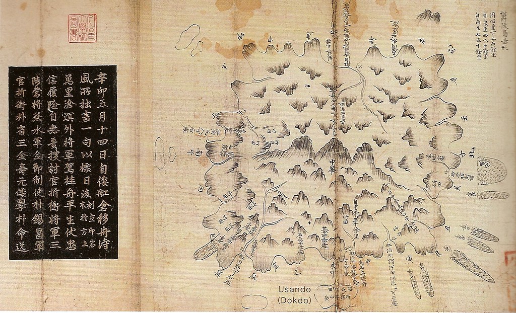
Below is a map of Ulleungdo (鬱陵島圖形) made by Inspector Bak Seok-chang (朴錫昌) after his inspection of the island in 1711. It was scanned from a book entitled, "Historical Evidence of Korean Sovereighnty over Dokdo," by Professor Lee Sang-tae of the Graduate School of Korea International Culture University. The map is important in the Dokdo/Takeshima debate because it not only shows Usando (于山島) as a neighboring island off Ulleungdo's east shore, but it also shows the small island as having grove(s) of haejang bamboo (海長竹田), which is a bamboo that can grow up to seven meters tall. That fact, in itself, eliminates any possibility that the Usando on this map could be "Dokdo" (Liancourt Rocks) since Dokdo does not have the soil needed to grow groves of bamboo.

In spite of the fact that the map shows Usando as a single island just off Ulleungdo's east shore that has groves of bamboo, the author of the book, Lee Sang-tae, still wrote "Dokdo" in parentheses next to Usando on the map. This is an example of just how blind Korean scholars can be when it comes to Dokdo (Liancourt Rocks), which is essentially two large, barren rocks ninety-two kilometers southeast of Ulleungdo.


The Chinese characters written on Usando can be seen more clearly on the following closeup of the island. They translate as follows: "groves of haejang bamboo, the so-called Usando" (海長竹田 所謂 于山島).


In 1694, sixteen years before the above map was made, Jang Han-sang (張漢相) also inspected Ulleungdo. In his report, Inspector Jang wrote the following:

東方五里許 有一小島 不甚高大 海長竹叢生於一面
동쪽으로 5리 (2킬로) 쯤에 한 작은 섬이 있는데, 고대(高大)하지 않으며 해장죽 (海長竹)이 한쪽면에 무더기로 자라고 있다.

About five ri (2 km) to the east (of Ulleungdo) is one small island. It is not very big or very high, and it has a grove of haejang bamboo (海長竹) growing on one side.
Notice that Inspector Jang also wrote about a small island with haejang bamboo two kilometers off Ulleungdo's east shore. The small island was almost certainly the Usando on the 1711 map.

About 2.2 kilometers off the east shore of present-day Ulleungdo is a small island called "Jukdo" (竹島), which still has groves of tall bamboo growing on it. The Usando on Inspector Bak's 1711 map and the small island mentioned in Inspector Jang's 1694 report were obviously not referring to "Dokdo" (Liancourt Rocks). Instead, they were almost certainly referring to Ulleungdo's present-day neighboring island of Jukdo. (Go HERE to read more about the 1694 inspection.)

The 1711 inspection occurred after the An Yong-bok incident, which means that An Yong-bok's "Usando" ended up being Ulleungdo's neighboring island of Jukdo (竹島), not Liancourt Rocks (Dokdo).

On the left side of the 1711 map is written the following:

辛卯五月十四日自倭舡倉移舟待風所拙書 一句以標日後(刻立卯岩木於方上)萬里滄溟外將軍駕桂舟平生伏忠信履險自無漫搜討官折衡將軍三陟營將兼水軍僉節制使朴錫昌軍官折衡朴省三金壽元倭學朴命逸

----------------

On March 14 in the "shin myo" year (辛卯 - 1711), we moved the boat from the Japanese boat house (倭舡倉) to the "wind-waiting place" (待風所). A verse was written and made into a sign for posterity (拙書一句以標日後). It was craved in wood and erected on a rock facing east (刻立卯岩木於方上):

On the distance blue sea, the general sails on a cinnamon tree ship. He has been loyal and faithful all his life, so even if there is hardship, there is no need to worry.
Inspector: Jeochung General (折衡將軍), Samcheok Camp Commander (三陟營將) & Navy Cheomjeoljesa (水軍僉節制使) Bak Seok-chang (朴錫昌)
Military Civil Servants (軍官): Bak Seong-sam (朴省三), Kim Su-won (金壽元)
Japanese Interpreter (倭學): Bak Myeong-il (朴命逸)

It seems that the above verse may have been what was written on one of the sign posts that are indicated on many old maps of Ulleungdo.

1737~1776 - 廣輿圖 - 江原道と鬱陵島

Gerryの投稿の日本語訳です。原文はこちら↓(English)
1737 ~ 1776: "Gwang Yeodo" (廣輿圖) - Gangwondo & Ulleungdo

下の地図は朝鮮の地図集である「廣輿圖 」のうち江原道と鬱陵島を描いたものです。この地図集自体は1737~1776年の間に作成されたと考えられています。江原道の地図は"關東道"という呼称で呼ばれています。これらはソウル大学奎章閣韓国学研究院にあります。

この江原道図について興味深いのは、鬱陵島に鬱陵島と干山島の両方の名前が併記されている事です。それは、この二島が隣り合わせにある事を意味していると考えられます。("干"山島は于山島の記述ミスだと思われます。)このことは同じ地図集(第七冊)の鬱陵島図によって追認されます。于山島は鬱陵島の東岸に小さな隣接島として描かれており、その小島には"所謂 干山島"と書かれています。
ところで、鬱陵島図の于山島にも江原道図と同じ記述ミス("干"山島)があることがお分かりでしょうか。また、于山島以外に鬱陵島の南岸に5つの小さな島が描かれていることに注意して下さい。これは、韓国の鬱陵島図に共通する特徴なのです。

世宗実録 地理志(1454) の中で、鬱陵島は蔚珍縣の項でこう記述されています。
于山武陵二島在縣正東海中二島相去不遠 風日淸明則可望見
韓国はこの記述を"于山"が"独島"(竹島/Liancourt Rocks)である証拠としており、この文中の距離は独島(竹島/Liancourt Rocks)と鬱陵島の間の距離であると主張しています。("武陵島"は鬱陵島の別名です。)しかし、日本はこの距離は蔚珍縣と鬱陵島と于山島二島の距離を意味している、と主張しています。下の江原道図はこの二島を一つの島として描いており、日本の主張の正しさ、つまりこの記述は二島間の距離ではなく、半島本土から二島までの距離を示している事を示唆しています。

江原道図と鬱陵島図のどちらも下のように注記が添付されています。江原図には域内の人口や田畑の数などが記載されています。又、鬱陵島図には島の大きさと動植物について記載されています。


2083031789_ef6536a388   2083031839_5010edd523_o   2083031995_282fa831f5

2083816212_894214069a_o   2083816084_e70e2afd06_o   2083032103_eb9da5fdc8_o