"East Sea and Dokdo in Old Maps " hosted by the Northeast Asian History Foundation The exhibition "East Sea and Dokdo in Old Maps " was held by the Northeast Asian History Foundation, that is research laboratories of the South Korea government, from this March 2 to the 9th at the the second floor of National Diet Library in South Korea. However, it made me feel that I was deceived by the extravagant advertisement, since there were only photographed panels in the hall not originals. According to the brochure distributed in the hall and the explanation of the hall, it seems they wanted to claim as follows.
"Regarding the name "East Sea", it is notable that certain old maps printed in European countries such as Germany, Russia and the United Kingdom had used the name even before it was marked as such in the due sea area on some Korean maps for the meaning of "an east side of Eurasia" at that time."
As for Takeshima, they also claim that "In the past, Korean called "Dokdo" as Usando, Sambongdo, Gajido or Seokdo", and " on those European old maps, Dokdo is referred to as 'Tchian-chan-tao', 'Liancourt Rocks', 'Hornet Rocks', 'Menelai' or 'Olivutsa'." They also seem to further claim that the label "East Sea" is correct for the Sea of Japan and Takeshima/Liancourt Rocks/Dokdo has historically been Korea's.
However, again, there was no grounds of Korea's claim to show why Takeshima is Korea's and Japan Sea should be called East Sea. Though the brochure says that "the name "East Sea" was marked as East Sea in the due sea area", throughout the Joseon Dynasty, the area of East Sea which corresponds to indicates Yellow Sea(黄海), Bohai Sea(渤海) or the eastern seaboard of the Joseon peninsula and those areas don't overlap the area of the "Sea of Japan". How does the Northeast Asian History Foundation" who sponsored this exhibition take this fact?
Their understanding of East Sea can be inferred from the explanation in the brochure, since they interpret the "Map of the Eight Provinces" (八道總圖 - 팔도총도) from "Sinjeung Dongguk Yeoji Seungram" (新增東國輿地勝覽 - 신증동국여지승람) as follows.
"Map of the Eight Provinces" is the complete map of Joseon which is collected first in the "Sinjeung Dongguk Yeoji Seungram". It only recorded simple information that everyone know, such as prominent mountains, rivers, islands and seas, in order to prevent the top secret of the state."
However, this explanation of "Map of the Eight Provinces" is only an arbitrary interpretation that neglects the document criticism. The postspcript of the map says "The complete map is a record for the ritual of worship(祀典)", meaning that the objects that the nation enshrines as spirits/gods of the nature are depicted in "Map of the Eight Provinces". Which means that the "East Sea" in not the label for the name of the sea, but for the places where the shrines of gods/spirits of the sea-waves along the eastern seaboards of Choson peninsula.
In fact, "The map of Kanwondo" from the same "Sinjeung Dongguk Yeoji Seungram" etc. labels the ocean as "東抵大海" (to the East, it reaches to the ocean) and "東北抵大海" (to the Northeast, it reaches to the ocean), making it clear that they are not coastal part, but the open seas far from the land. In short, the majority of the Sea of Japan area was recognized as "大海"(ocean), not "東海(East Sea)" in those old Korean maps.
Moreover, the "East Sea"(東海) defined in the worship(祀典) can be also confirmed in the "Samguk Sagi"'s Monographs part (三国史記 雑志) that was compiled in Goryeo era. And it indicates the coast part of the Korean peninsula's east shore throughout the age of Silla, Goryeo and Joseon. Against this historical fact, Korea's Northeast History Foundation misread the Chinese character "東海", replacing with "日本海"(the Sea of Japan) in the modernistic way of thinking, and falsely claimed that "東海" in the maps are the historical evidence to show ancient Korean called the Sea of Japan as East Sea. However, it was after modern ages that the name's of the Sea of Japan as East Sea became general, and East Sea until a Joseon age indicated the coast part of the Korean peninsula east shore, Yellow Sea and Pohai.
The similar example of their stretching interpretation "East Sea" far to the Sea of Japan can be seen in their explanation of "A Map of Marco Polo's Voyages" as well. The map was produced by British Emanuel Bowen in 1744 and it labeled the area as "EASTAN SEA" on the are of the Sea of Japan. They explained it is the evidence that western society called the Sea of Japan as East Sea in the brochure. However, as was explained, Korea's "East Sea" indicated the coastal part of Korean peninsula's eastern part, and it doesn't overlap with "EASTAN SEA" that corresponds to the Sea of Japan. And yet from the point that "EASTAN SEA" actually is written in "A Map of Marco Polo's Voyages", it should be translated rather as "Eastern Sea" or "Sea in the East" to follow the Marco Polo's "The Book of Marco Polo" which is nicknamed as " Oriente Poliano". But they explain it as "regarding the name "East Sea", it is notable that certain old maps printed in European countries such as Germany, Russia and the United Kingdom had used the name even before it was marked as such in the due sea area on some Korean maps" without any fact as such, in their brochure and the board on the hall. It is because there are overwhelmingly numbers of western old maps which label the sea area concerned to be "Sea of Japan", "Goryeo sea" and "Joseon sea", but "East Sea".
Therefore, the exhibition "East Sea and Dokdo in Old Maps " will, on the contrary to their expectation the world to correct the Sea of Japan as East Sea, have proven the fact that East Sea claimed by South Korea doesn't overlap with the Sea of Japan. Keeping fabricating the history of the lie, and cheating the inside and outside the country only complicate relations between Japan and South Korea fruitlessly. This kind of political advertisement never leave an excellent result to future generations, but simple international reliability to South Korea is lowered and the stain is left for the history, .
The same thing goes to their other explanation that "the claim by Japanese Government that Japan had owned Takeshima before 1905 is false" because "The map of the Great Japan", which the bureau of the staff of a Japanese army(日本陸軍参謀局) produced in 1877, does not depict Takeshima. This kind of sophistry comes from the disregard for the historical fact as is explained later.
It is necessary to clarify to which of historical titles of Takeshima in Japan-South Korea to belong when the Takeshima Issue as the history issue is discussed. They dissemble as if Korea's historical base on Takeshima/Dokdo sovereignty is well-grounded, by explaining that Liancourt Rocks have been "called as Usando, Sambongdo, Gajido and Seokdo, etc..." and the islets were labeled as "Tchian-chan-tao、Liancout Rocks、Hormet Rocks、Menelia or Olivutsa, etc... in old western maps." However, unfortunately, there is anything that shows Korea's historical title on Takeshima at all.
Although Korean claim that they called today's Takeshima as Usando, Sambongdo, Gajido and Seokdo, etc...", but that is absolutely groundless as I have already proved empirically in my article "A Study on the Name of Dokdo". Accordingly, as far as Korean has been keep failing to prove they had owned Takeshima/Dokdo before 1905, the year Japan officially incorporated Takeshima into Shimane Prefecture, Korea does not deserve to criticize Japan. The exhibition and their sophistry practically prove that they don't understand the historical background of Takeshima Issue at all. The origin of the issue can be traced to 18th January, 1952, the day Korean government installed the illegal delineation "The Syngman Rhee Line", encompassing the island of Takeshima and a large area of water with fisheries jurisdiction, over international waters. Afterwords, South Korea was yet able to prove it was historically Korea's territory, and all they talk was big brag "The territorial issue doesn't exist between Japan-South Korea", though the government of two countries exchanged memos, and repeated a formal controversy until the 1960's. This is the reason the government of Japan accuse Takeshima occupation in 1954 by South Korea to be an illegal occupancy. Korea's Takeshima/Dokdo Research has been carried out on the assumption that "Dokdo is our territory (Takeshima is South Korea's territory)", and they interpreted documents and old maps, which has no competence to prove the sovereignty in the first place, arbitrary to claim their legitimacy. The exhibition "East Sea and Dokdo in Old Maps " fall under this category. The background why such events are repeatedly held is it originates in the fact that the past Takeshima controversy between Japan-South Korea was irregular.
Although it is already proven that Takeshima was not Korea's territory in the view of history, there are two opinions concerning of the Takeshima Issue. Shimane Prefecture's Takeshima Research Center, that summarized the point of issue, concluded that Takeshima is Japanese territory on the ground the fact then Meiji government named Liancourt Rocks, of which there were no traces of occupation by any other countries / Terra nullis, and incorporated into a Japanese territory in accordance with International Law in 1905. While Ministry of Foreign Affairs of Japan concludes that Takeshima is Japanese territory from Edo period, from the details of the controversy by the exchange of memos of Japan-South Korea so far.
Then, South Korea that wanted to refute the Japan's claim at any cost disregarded the opinion of the Takeshima Research Center of Shimane Prefecture and made the opinion of the Ministry of Foreign Affairs a subject of discussion. This time, they presented "The complete map of Japan"(大日本全図) as the grounds of an argument that the bureau of the staff of a Japanese army(日本陸軍参謀局) produced in 1877. According to their explanation, it supposed to be "the proof of Japanese Government's opinion that Japan had owned Takeshima before 1905 is false" since Takeshima was not depicted.
However, it is natural that Takeshima that became a Japanese territory in 1905 doesn't exist in the map of Japan produced before 1905. No matter how maps that similar to this "The complete map of Japan" are collected, it hardly become any evidence to prove Takeshima is South Korean territory. South Korea's, who lacks empirical evidence to prove Takeshima is South Korea territory, claim that "Japanese government claim falsely" is just a propaganda maneuvers to justify their illegal occupancy of Takeshima. "False claim" is not on Japanese side, but on Korean side, who herself accuse Japan of false claim.
In fact, there is Korea's deceit behind the words the brochure says, "Dokdo is referred to as 'Tchian-chan-tao', 'Liancourt Rocks', 'Hornet Rocks', 'Menelai' or 'Olivutsa' in western old maps." The name "Liancourt Rocks" originate from the fact French whaler Liancourt found the islets in 1849. "Hornet Rocks" originate from the fact that British warship H.M.S. Hornet identified them and plotted on the nautical-chart in 1855. "Menalai and Olivutsa Rocks" again originate in the fact Russian frigate Paleada have surveyed the island and named it Olivutsa(Оливуца) & Menelai(Менелай) in 1854. Accordingly, there are concrete reason that Takeshima/Dokdo was named as such in western old maps. The point is, "Tchian-chan-tao" (the sound of the Chinese word "千山島") is not today's Takeshima/Dokdo. "Tchian-chan-tao" in western old maps comes from "Map of the Eight Provinces" (八道總圖 - 팔도총도) in ”A Revised Edition of the Augmented Survey of the Geography of Korea” (新增東國輿地勝覽 : The Sinjeung Dongguk Yeoji Seungram) indicates "千山島" and it does correctly indicates "千山島". However, "千山島" in "Map of the Eight Provinces" is the same island with different names of Ulleungdo, and it has no relationship with Takeshima in territorial dispute between Japan-Korea. "千山島" in "Map of the Eight Provinces" is depicted between Joseon peninsula and Ulleungdo, and it is apparent from the description of "Annals of King Taejong" (太宗實錄 - 태종실록) , which was quoted in ”The Sinjeung Dongguk Yeoji Seungram”, that it was another name of Ulleungdo. However, problem is, the incorrect geographical knowledge of "Map of the Eight Provinces" was followed suit by western old maps (Note by translater ; via China) and Usando, which is the same island/different name of Ulleungdo, imparted to as well. "Royaume de Coree" by French royal geographer D'Anville in 1737, which was on display at the exhibition, is one of those maps and it is the ringleader who confuses the Western old maps. "The Chart of Japan" by William Heine, who accompanied the first expedition of the US fleet under Commander Matthew Perry to Japan as an official artist/book illustrator in 1853, depicts three islands, "Takeshima"(Argonaut=non-existant),"Matsushima"(Ulleungdo/Dagelet), "Hornet Rocks"(today's Takeshima), plus two islands "Pan-ling-tao", which indicates Ulleungdo and "Tchian-chan-tao" which originates in "千山島" in the vicinity of the East coast of Joseon peninsula. Same goes to "(U.S) Navy Chart of the Coast of China 、Pacific coast (Asia), Japan islands Copied to ordered by Commandar Mattew Perry(1855)", a foldout map in "The Narrative of the Commodore Matthew Calbraith Perry's Expedition to Japan", and it depicts two Ulleungdos, namely "Dagelet or Matsushima"(=Ulleungdo) and "Pan-ling-tao"(=Ulleungdo), following the geographical knowledge of "Royaume de Coree" by D'Anville.
The exhibition "East Sea and Dokdo in Old Maps " held by the Northeast Asian History Foundation arbitrarily decide ”Tchian-chan-tao” in "Royaume de Coree" by D'Anville is today's Takeshima, but in fact, ”Tchian-chan-tao” only followed the mistake of "Map of the Eight Provinces". Therefore, it can never become a evidence for Korea's sovereignty over Takeshima.
Korean side claim Takeshima is their territory by arbitrary interpreting the documented source or old maps neglecting document criticism, however, this kind of claim, which lacks the technique of a fair historical study, is nothing but just a reckless remark.
 "The New Detailed Map of Japan, Russia, China and Korea"(日露清韓明細新図) which Korea's Dokdo Institute of Yeungnam University opened on this April 1 to the public is not the exception. The map is written as to have been produced by "The Department of Survey of Imperial Army/
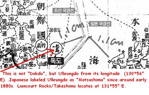
Navy"(帝国陸海測量部) in 1903, and borderline is appearing between Japan and Korea with "Takeshima" and "Matsushima" on Korean side. Dokdo Institute of Yeungnam University claimed that the map "depict what Japanese call "Takeshima=Ulleungdo" and Matsushima=Dokdo" belong to Joseon territory", and Kim Hwa-Kyung(金和経), the head of the Institute, said that "Japan should discontinue the insistence on the sovereignty over Dokdo in the situation with evidence Japan himself divided the border voluntarily recognizing the South Korean territory Dokdo". (Note by translator : There was no such department as "The Department of Survey of Imperial Army/Navy"(帝国陸海測量部) in Military history of Japan. This handy map is apparently produced by non-official Mr. Kurimoto(東京日本橋:栗本長質), the private mapmaker who seems to have tried to sell the map under a fake official name. The map is made for the soldier who goes to war to the oversea land. ) However, "Takeshima" and "Matsushima" in "The New Detailed Map of Japan, Russia, China and Korea"(日露清韓明細新図) are phantom island "Argonaut" and "Ulleungdo", respectively, apparently from their longitude. Because, Ulleungdo had been recognized as "Matsushima" in Japan since about 1883(16th year of Meiji). The remote cause of the confusion is Philipp Franz von Siebold's map "Karte vom japanischen Reiche, nach Originalkarten und astronomischen Beobachtungen der Japaner die Inseln Kiusiu, Sikok und Nippon"(1840) , which depicts "Takasima (I. Argonaute)", the island of uncertain whereabouts (129°50" E) and Ulleungdo as "Matsusima (I. Dagelet)" (130°56" E). Therefore, after this Siebold's map, western maps and charts depict phantom island "Takeshima=Argonaut" and "Matsushima=Dagelet", which is Ulleungdo, and Japan followed it. Takeshima, which is currently occupied illegally by South Korea, locates at 131°55" E. Accordingly, it has nothing to do with "Take(a)sima" (129°50" E) nor "Matsusima" (130°56" E) in Siebold's map "Karte vom japanischen Reiche, nach Originalkarten und astronomischen Beobachtungen der Japaner die Inseln Kiusiu, Sikok und Nippon"(1840).
Therefore, "Takeshima" and "Matsushima" in "The New Detailed Map of Japan, Russia, China and Korea"(日露清韓明細新図) (1903) are phantom island "Argonaut" and "Ulleungdo", respectively, and it is also apparent from their longitude and latitude. For that reason, it is prejudiced opinion to disregard the fact of the history for Kim Hwa-Kyung(金和経), the head of the Institute, to have said that "It is the evidence Japan himself divided the border voluntarily recognizing the South Korean territory Dokdo". Takeshima/Liancourt Rocks, which used to be called as "Matsushima" by Japanese in Edo era, was officially named as "Takeshima" when it was incorporated into official Japanese territory in 1905, being switched by the old name of Ulleungdo, which used to be called as "Takeshima", because of mislabel of Ulleungdo as Matsushima in Siebold's map "Karte vom japanischen Reiche, nach Originalkarten und astronomischen Beobachtungen der Japaner die Inseln Kiusiu, Sikok und Nippon"(1840).
"Takeshima" and another island = "Matsushima" of the Dajokan instruction, which Korean frequently takes up for a subject for discussion, simply meant that phantom island "Takeshima" and "Matsushima" as a another name of Ulleungdo, and it didn't instructed that today's Takeshima to be outside the territory of Japan. South Korean seems tend to interpret documents and maps recklessly in order to make Takeshima/Linancourt Rocks is Korea's territory. However, it is impossible and unreasonable for them to claim Takeshima which have never been their own territory in the first place, as their own.
Finally, both the exhibition "East Sea and Dokdo in Old Maps" and the Dokdo Institute of Yeungnam University are interpreting documents and a part of the old map arbitrary, and fabricating the history of the lie. This kind of act will leave the wound with irreparable relations between Japan and South Korea. This is a reason to dare to give unpleasant but wholesome advice.
The 22th column “ Refutation against "The Meiji Government's recognition of Takeshima=Dokdo" by Mr. Park Byeong-seop(朴炳渉)””,


