 Answer: Ulleungdo (鬱陵島 - 울릉도) has two neighboring islands, Jukdo (竹島 - Jukdo) and Gwaneumdo (觀音島 - 관음도), but Jukdo is the largest. Korea also considers Dokdo (獨島 - 독도) a part of Ulleungdo county, but Dokdo would not be considered a neighboring island since it is about ninety-two kilometers southeast of Ulleungdo. Dokdo is called Liancourt Rocks in the West and Takeshima (竹島) by the Japanese. Koreans use the same Chinese characters for Ulleungdo's neighboring island of Jukdo (竹島) as the Japanese use for Takeshima (竹島), which causes confusion for some people.
Geography
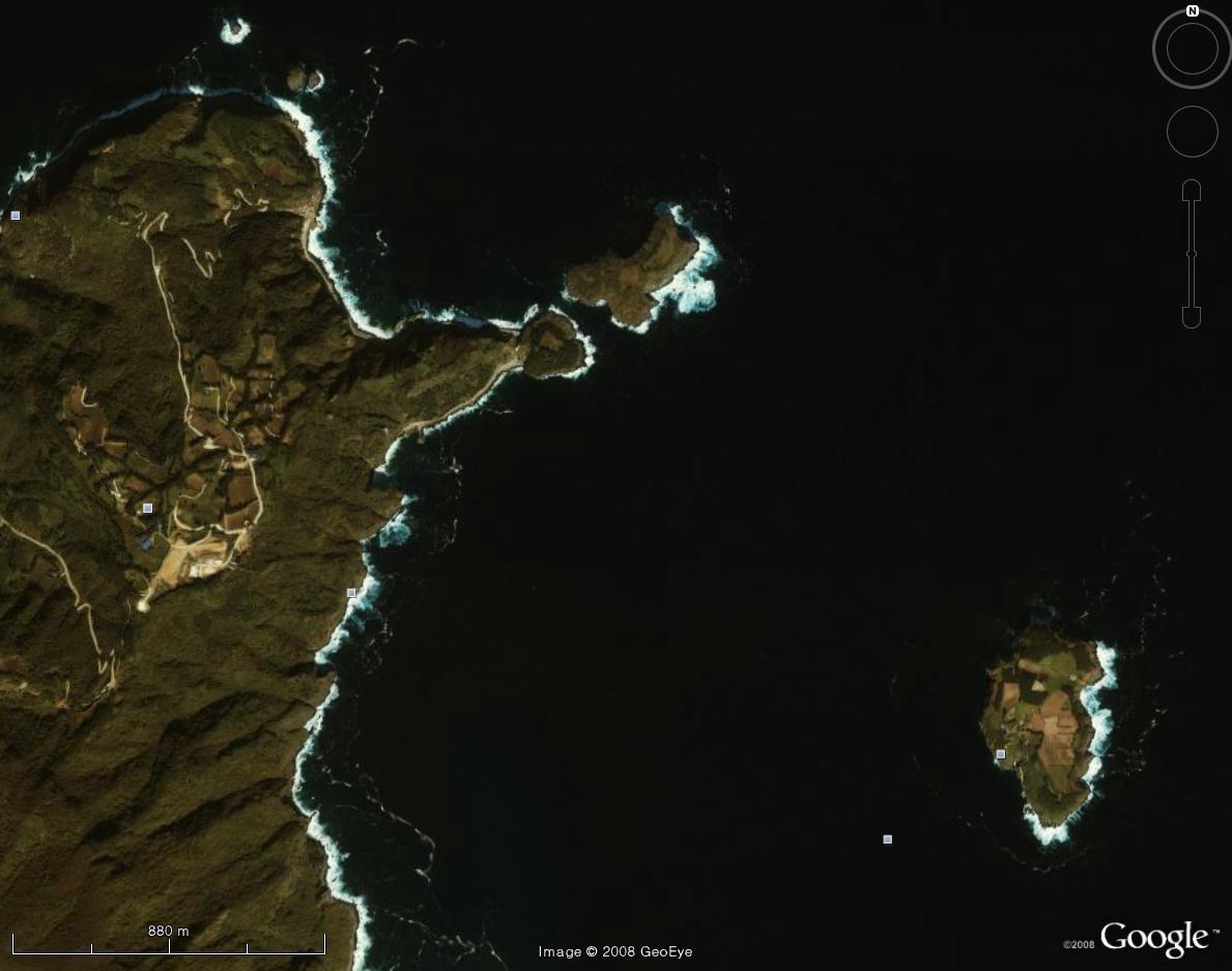
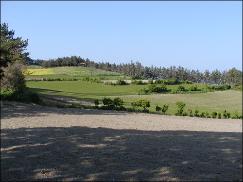
As already mentioned, Jukdo (竹島 - 죽도) is Ulleungdo's largest neighboring island and is located about 2.2 kilometers off Ulleungdo's east shore, and is about four kilometers north of Ulleungdo's Jeodong Harbor (저동항). It has a total area of 207,818 sq. meters, which is about fifty-one acres. There are currently about thirteen acres under cultivation. The island is shaped similar to a pine cone and has a top surface that is fairly level. It stands about 116 meters out of the water. There are sheer cliffs on all sides, except for a steep narrow path leading up onto the island on one side. In 1993, a spiral staircase was built as part of an effort to turn the island into a tourist attraction by giving easier access to it. A boat dock was also built. Currently, only a father and son live on the island, but when the father first moved there in the 1960s, four or five other families were already living there. There is no water on the island, so they get their water by collecting rainwater. (Korean Reference)
Climate
 The area has an oceanic climate, so it gets a lot of rain. It has an annual average rainfall of 1,236.2 mm, which is fairly evenly spread thoughout the year, though August and September get about 24 percent more than the monthly average. The area also gets a lot of snow, with snow falling an average of 57.8 days a year. The average annual temperature of the area is relatively low at 12.3°C, with average highs reaching 26°C in August and average lows reaching -1.0°C. in January. (Korean Reference)
(The photo to the right is a satellite image of the northeast shore of Ulleungdo and Ulleungdo's largest neighboring island of Jukdo (竹島 - 죽도).
Different Names for the Island
The name "Jukdo" (竹島) means "Bamboo Island." The island apparently got its name from the fact that a lot of bamboo grew there. During a 1694 inspection of Ulleungdo, an island two kilometers off Ulleungdo's east shore was described as having haejang bamboo growing thickly on one side. The island has also been called "Muleungdo" (武陵島 - 무릉도), "Usando" (于山島 - 우산도), "Bangbaedo" (防牌島), "Dae Udo" (大于島 - 대우도), "Dae Gando" (大干島 - 대간도), "Songjukdo" (松竹島), "Songdo" (松島), and "Daet-seom" (댓섬), though some of these names are disputed by some Koreans.
 Island History
Ulleungdo's neighboring island of Jukdo was most likely first mentioned in Korean history in 1412, when twelve people sailed into a harbor near Koseong (高城 - 고성), on the east coast of Korea, and said they were from "Yusanguk Island" (流山國島), which was a misspelling for "Usanguk Island" (于山國島). Usanguk was the old Korean name for Ulleungdo. In their testimony to Korean officials, they said that eleven families with a total of sixty people or more had lived on an island named "Muleungdo" (武陵島), but they had moved and were now living on the "main island," which means the main island was "Usangukdo, and its neighboring island was "Muleungdo." That means the neighboring island was almost certainly Ulleungdo's neighboring island of Jukdo. The island could not have been Dokdo because Dokdo was ninety-two kilometers away and could not have supported eleven families with a total of sixty people or more since Dokdo is just barren rocks with little or no soil to grow food and little or no drinking water. (1412- 太宗實綠 - 태종실록)
Also, in 1416, former governor of Gangwon Province, Bak Seup (朴習 - 박습), said that he heard that Ulleungdo had a small neighboring island next to it. He then said that the island had fifty kyeol of farmland and a narrow entryway that only allowed peolple to enter single file. It is not clear if he was referring to Ulleungdo or Jukdo, but Ulleungdo has more than just one narrow entry onto the island, so it is more likely he was referring to Jukdo. He also said that he heard fifteen families lived on the island. Bak Seup was governor of Gangwon Province from 1411 through most of 1412 before being sent to China, and again in 1413 after returning from China, so he may have been referring to the families mentioned in the previous paragraph or maybe to another group that was not mentioned in official records. (1416 -太宗實綠 - 태종실록)
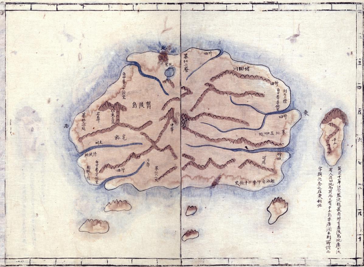 The map to the right is a cutout of a map of Ulleungdo from Kim Jeong-ho's (金正浩 - 김정호) 1834 atlas "Cheongu-do" (靑邱島 - 청구도). The markings on the edge of the map represent ten ri segments, which was about four kilometers. That means that the small island shown off the east shore and labeled as "Usan" (于山 - 우산) was draw as being about four kilometers offshore of Ulleungdo, which means it was almost certainly Ulleungdo's neighboring island of Jukdo.
As mentioned above, after an inspection in 1694, Ulleungdo Inspector Jang Han-sang (張漢相) described an island two kilometers off Ulleugdo's east shore as having haejang bamboo growing thickly on one side. In 1711, Ulleungdo Inspector Bak Seok-chang (朴錫昌) drew a map of Ulleungdo that showed an island just off the east shore labeled as "the so-called Usando" (所謂 于山島 - 소위 우산도). He also wrote on the island the words "fields of haejang bamboo" (海長竹田 - 해장죽전). That island was almost certainly the same island described by Jang Han-sang in 1694 as being two kilometers off Ulleungdo's east shore. The island could not have been Dokdo because Dokdo is just barren rocks without the soil needed to grow bamboo.
In 1786, Ulleungdo Inspector Kim Chang-yun (金昌胤 - 김창윤) reported that "Bangpaedo (防牌島 - 방패도) was about 1.2 kilometers east of the "main island."
In 1794, Ulleungdo Inspector Han Chang-guk (韓昌國 - 한창국) reported finding three islands offshore of Ulleungdo--"Bangpaedo" (防牌島), "Jukdo" (竹島), and "Ongdo" (翁島)--but he described the distance between each of the three islands as being only 100 paces, which means we do not really know what islands he was referring to because it does not describe the geography correctly.
In 1807, Ulleungdo Inspector Lee Tae-geun (李泰根 - 이태근) said the island of "Usando" (于山島 - 우산도) was north of this location on Ulleungdo and that it was about 0.8 to 1.2 kilometers in diameter.
King Kojong (高宗 - 고종왕) also mentioned Jukdo in 1882 when he said Ulleungdo had a neighboring island named "Songjukdo" (松竹島 - 송죽도), which he said was sometimes called "Songdo" (松島) and sometimes called "Jukdo" (竹島). (Reference)
 Maps
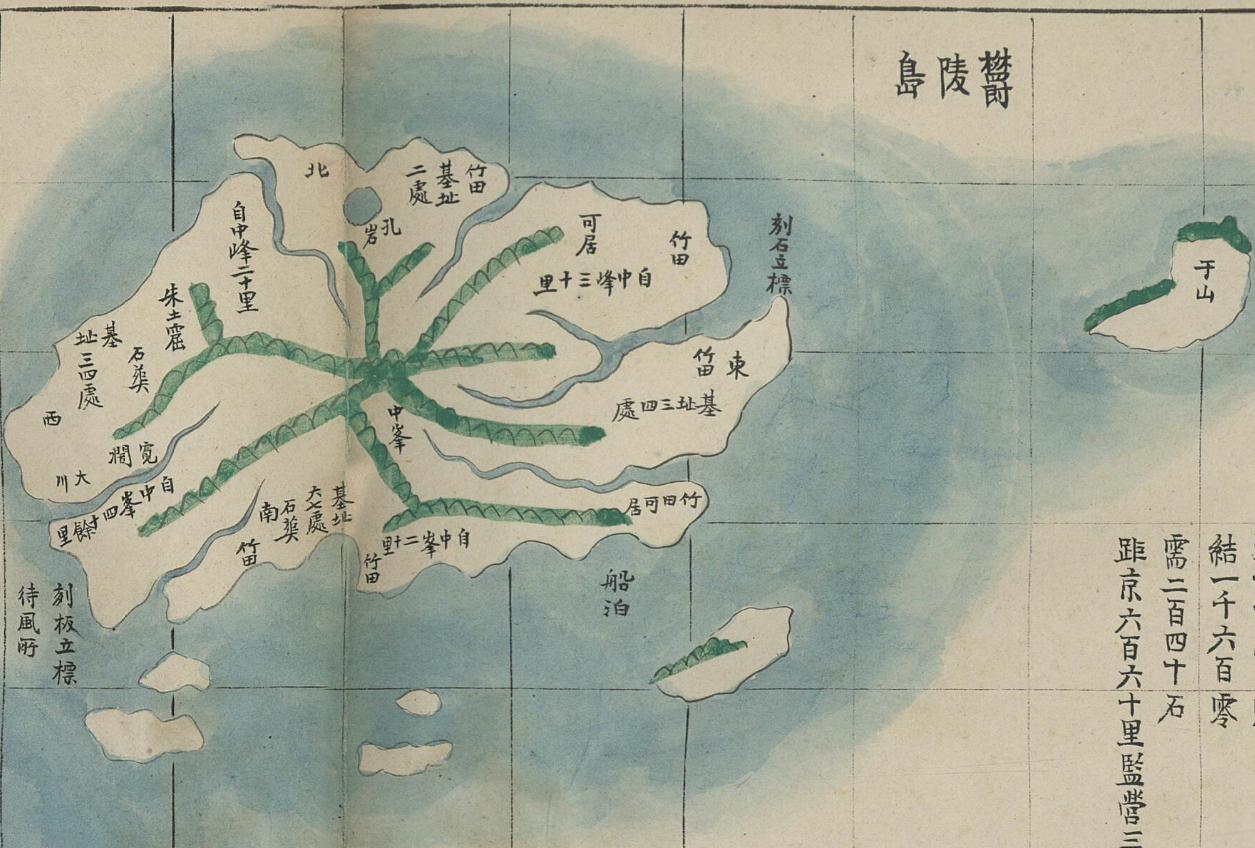
MapsMost of Korea's maps of Ulleungdo, beginning from the early 1700s to 1899, show Ulleungdo's neighboring island of Jukdo labeled as "Usando" (于山島) or "Usan" (于山). For example, the map of Ulleungdo to the right was made between 1884 and 1894, which was after Koreans started settling on Ulleungdo. The map shows an island off the east shore of Ulleungdo labeled as "Usan" (于山 - 우산). The island was almost certainly Ulleungdo's Jukdo.
Koreans claim that Usando was Dokdo (Liancourt Rocks), but they have no maps or clear documentary evidence to support that claim. In fact, there are no Korean maps showing Dokdo by any name. Almost all the evidence says that Usando was Ulleungdo's neighboring island of Jukdo.
4-Part KBS Documentary on Jukdo
1711 - Bak Seok-chang''s (朴錫昌) Map of Ulleungdo
1807 May 12 - Lee Tae-gun (李泰根) Inspects Ulleungdo
19th c. Map of Ulleungdo: "Ulleungdo Dohyeong" (鬱陵島圖形), property of Samcheok Museum
1882 April 7 - King Kojong says Usando Neighboring Island of Ulleungdo
Okay, I've got two more questions for you.
ReplyDelete1. Is there a historical evidence of Dokdo, not Jukdo, being called 'Takeshima'?
2. How could you explain the controversy over defining a national territory: "Dokdo would not be considered a neighboring island since it is about ninety-two kilometers southeast of Ulleungdo"(re: Q2); and "...it may have been drawn because it is located at near Chosun. One can't claim ownership from this kind of map."(re: Tsusima)?
I'm looking forward to read your posts.
Thanks.
David Ko
David,
ReplyDeleteAs far as I know, Dokdo (Liancourt Rocks) was not called "Takeshima" (竹島) by Japan until Japan incorporated the rocks in 1905. Before 1905 Liancourt Rocks were referred to by the Japanese as "Matsushima" (松島 - Songdo) or by the Japanese pronunciation for Liancourt Rocks.
People often ask why the Japanese call Liancourt Rocks "Takeshima" (竹島 - 죽도), which means "Bamboo Island," when there is no bamboo on the island. That is because Takeshima used to be the Japanese name for Ulleungdo, but the mismapping of Ulleungdo by the Bristish ship "Argonaut" caused the Japanese to think the non-existent island of Argonaut was Korea's Ulleungdo and the island southeast of there, which was the real Ulleungdo," to be the Japanese island of Matsushima. When the Japanese learned in 1880 that Matsushima was actually the Korean island of Ulleungdo and that Ulleungdo had a neighboring island called Jukdo (竹島 - 죽도), which is the Korean pronunciation for Takeshima, the Japanese continued to refer to Ulleungdo as "Matsushima" and old their old Matsushima (Liancourt Rocks) by the Western name "Liancourt Rocks." However, when the Japanese incorporated Liancourt Rocks in 1905, they abandoned the Western name and gave the rocks the Japanese name of "Takeshima" (Bamboo Island), even though there is no bamboo on the island. I do not know exactly why they chose the name "Takeshima," but I would guess they did it because the name had been a part of Japanese history in the region since the 1600s.
Dokdo did not appear on Korean maps by any name, but it did frequently appear on Japanese maps of both Korea and Japan labeled with the Japanese name of "Matsushima" and later with the Western name "Liancourt Rocks."
Just because an island appears on a map of a country does not mean it is that country's territory. Tsushima (大馬島 - Daemado) is the perfect example. It was not a Korean island, but the Japanese and Koreans drew it on their maps of Korea because it was near Korea. Liancourt Rocks was a similar situation. The northeast corner Korea extended far enough east that much of the Sea of Japan would was included in a map of Korea, including the portion of the sea that included Liancourt Rocks.
I hope that explains it.
You are welome, David.
Hi, David Ko
ReplyDeleteLincourt Rocks were re-named as a new "Takeshima" in 1905 because ancient Takeshima(Ulleungdo) was called "Matsushima", which was today's Takeshima's old name, in Meiji. On the other hand, Takeshima/Liancourt Rocks/Dokdo was called "Yanko" by Japanese fishermen in Meiji (and Korean also used this Japanese "Yanko", not Seokdo(石島), Usando(于山島) nor Dokdo(独島) from 1900-1904, which suggests the fact Korean only got to know Takeshima/Dokdo through Japanese.), but Matsushima(松島) in Edo era. As for the name confusion and naming Liancourt Rocks as Takeshima, please read MOFA's site below.
Charting error by European explorers and others
"(1) In 1787 the French explorer Jean-Francois de Galaup, Comte de La Perouse reached Utsuryo Island, which he named "Dagelet." Following that, in 1789 the British explorer James Colnett also found Utsuryo Island, to which he gave the name "Argonaut." However, as there was some discrepancy in their latitudes and longitudes of Utsuryo Island as recorded by de La Perouse and by Colnett, in subsequent European maps Utsuryo Island was depicted as apparently two separate groups of islands.
(2) In 1840, a doctor named Philipp Franz von Siebold, who had worked as a physician on the island of Dejima in Nagasaki, created a "Map of Japan." He had known from various Japanese documents and maps that between the Oki Islands and the Korean Peninsula there were two groups of islands, "Takeshima" (current Utsuryo Island) and "Matsushima" (current Takeshima) from the west to the east. At the same time, he also knew that on European maps, there were two groups of islands named "Argonaut" and "Dagelet" from the west to the east. In Siebold's map he records "Argonaut" with its Japanese name "Takashima" and "Dagelet" with "Matsushima." This invited a distortion and confusion of the names of the current Utsuryo Island, which until then had consistently been called "Takeshima" or "Isotakeshima," assumed additional name of "Matsushima."
(3) In this way, long-held knowledge concerning "Takeshima" and "Matsushima" in Japan was subsequently confused with the names given to the islands by Westerners, but in the midst of such confusion a Japanese who saw "Matsushima" at a distance requested the government to develop the island. The government implemented a field study in 1880 in order to clarify the relationship among the different names of the islands, and it was confirmed that the island referred to as "Matsushima" in the request was actually Utsuryo Island.
(4) Based on the above, Utsuryo Island came to be called "Matsushima," which raised the question of how to call the current Takeshima. In order to resolve this issue the government of Japan, hearing opinions of Shimane Prefecture, in 1905, officially named the current Takeshima as such, replacing the name it had held until that time (Matsushima)."
You can see those process in the Shimane prefecture's inernal corresponding letters.
Toron's site
庶第一〇七三号
周吉郡西郷町中井養三郎より領土編入並に貸下の件別紙之通出願に付目下調査中之題に候処弥々所属を定めらるる場合に於ては隠岐島庁の所管とせらるるも差支なき御見込に候や又島嶼の命名に付せて御意見承知致度此段及照会候也
明治三十七年十一月十五日
島根県内務部長
書記官 堀 信次
隠岐島司 東 文輔殿
乙庶第一五二号
本月十五日庶第一〇七三号を以て島嶼所属等の義に付御照会之趣了承右は我領土に編入の上隠岐島の所管に属せらるるも何等差支無之其名称は竹島を適当と存候
元来朝鮮の東方海上に松竹両島の存在するは一般口碑の伝ふる所而して従来当地方より樵耕業者の往来する欝陵島を竹島と通称するも其実は松島にして海図に依るも瞭然たる次第に有り之候
左すれは此新島を措て他に竹島に該当すへきもの無之依て従来誤称したる名称を転用し竹島の通称を新島に冠せしめ候方可然と存候
此段及回答候也
明治三十七年十一月三十日
隠岐島司 東 文輔
島根県内務部長
書記官 堀 信次殿
Originally,Usando was Ulleungdo,I think.
ReplyDeleteThere is Woosan Middle School in Ulleungdo.
http://woosanms.co.kr/?p=contents.1014
On Ulleungdo,there are the people who are living with the pride of old country of Woosan(Usan).
Though Koreans claim that Usando was Dokdo,will not it hurt their pride?
Gerry,
ReplyDeleteThanks a lot for this interesting and educational article.
I hope many Korean people will read this article. And please ask us if you have any questions like david ko.
Matsushima was actually Ulleung-Do so the japanese had no idea of Dokdo.
ReplyDeleteYou`re actually saying that the island "Usando" or "Usanguk" is referring to Jukdo. In the same text you`re stating that in 1412 "Usanguk" was Ulleungdo, the main island. But it seems impossible to you that "Usando" is referring to Dokdo. Why?
ReplyDeletehelpfish,
ReplyDelete"You`re actually saying that the island "Usando" or "Usanguk" is referring to Jukdo. In the same text you`re stating that in 1412 "Usanguk" was Ulleungdo, the main island."
It seems that they used the word "Usanguk" first in the history which meant a country of Usan, not always mean one island but possibly a group of islands including Ulleungdo.
Then they used the word "Usando" for one island where people could live, most possibly Ulleungdo.
After that, as you can see in various maps and documents, the word "Usando" began to indicate today's Jukdo.
"But it seems impossible to you that "Usando" is referring to Dokdo. Why?"
First of all, Liancourt Rocks are two rock islets without soil and drinking water where no human beings could live, while many documents say that there were people living with horses etc.
As to the Japanese name of "Matsushima", it was used for Liancourt Rocks in the 17th century and 18th century, but after the western maps depicted Argonaut and Dagelet islands they began to use the name for Dagelet island (Ulleungdo) as you say while Liancourt Rocks were called by Japanese as "Riyankourudo Iwa" , "Ryanko island", or "Yanko island" - translated name of Liancourt Rocks. Japanese never lost Liancourt Rocks.
1. The japanese renamed Dokdo to Liancourt rocks. At that point they`ve given up any claim.
ReplyDelete2. Please read the post again. He is clearly saying that Usan-Do should be Ulleung-Do.
helpfish,
ReplyDeleteYou wrote;
"1. The japanese renamed Dokdo to Liancourt rocks. At that point they`ve given up any claim".
I can't understand what you mean. Japanese have never ever renamed "Dokdo". They renamed Liancourt Rocks to "Riankorudo Iwa" or "Ryanko island" when old name of Matsushima began to indicate Ulleungdo because of western maps saying Dagelet island (Ulleungdo) = Matsu-Shima.
So Japanese always had names for Liancourt Rocks since 17th century, while Korea had no name for Liancourt Rocks until 20th century.
The name of "Dodko" was created in the 20th century, which may mean they didn't know Liancourt Rocks.
You also wrote;
"2. Please read the post again. He is clearly saying that Usan-Do should be Ulleung-Do".
Yes, Usando was Ulleungdo in the early stage of history. They used to call the island group (today's Ulleungdo, Jukdo and tiny islets around Ulleungdo) as "Usanguk". The main island of Usanguk was Ulleungdo and it is natural to call the main island as Usando.
After the years, Usando began to indicate Jukdo.
But anyway, Usando was not Liancourt Rocks.