竹島問題の歴史

29.10.08

1903 German Map of Japan which was owned by German Embassy

This German topographical map of Japan was published in Leipzig in 1903. This map has a grave meaning because it had been used in the German Embassy in Tokyo until it was brought out after the World War II, which may mean that the map was recognised as one of the most accurate maps of Japan by Germany as a nation from 1903 until 1945.

Please take a look at the islands in the Sea of Japan. Ulleungdo was labelled as "Matsu-sh. (Dagelet I.)" and Liancourt Rocks were labelled as "Liancourt Rocks / Hornet In." and both of the islands were coloured green - the same colour as Japan mainland.
..................
..................
..................................................

This is another evidence to show that western countries, including the Embassy of a western country, recognised that Liancourt Rocks were not Korean territory in 1903 - three years after the promulgation of the Korean Edict #41 and two years before the incorporation of the rocks into Japan.
Korea actually didn't own Liancourt Rocks, at least the world didn't recognise that Korea owned the rocks.
....................................................


...................................................


27.10.08

1941 - ”Geography Text of Kangwon Province (江原道誌)” reconfirms it is Ulleungdo which can be seen and it is from Ulgin

”Geography Text of Kangwon Province (江原道誌)” was first published in 1940, while Korea was under Japanese Annexation. I'm not sure if the text was written by Japanese or Korean, but it was written in old Chinese (漢文), which was very rare in Japan in 1940s. Though it was published years after Japan's incorporation of Takeshima into Shimane in 1905, it still shows many interesting points.

The most important point in the text is that it clearly states that "Ulleungdo can be seen from Ulgin", Choson peninsula, not "Usando from Ulleungdo" like pro-Korean insist. In addition, it states Ulleungdo locates at the 135° 5′ E, which seems to be the mistake of at the 135° 55′ E, which is the Eastern longitude of Jukdo(竹島). ( Jukdo(竹島) was included in the section of "山川(Mountains and Rivers)", but not Dokdo, Usando nor Seokdo or any other name Korean claim as other names for Takeshima/Dokdo.)
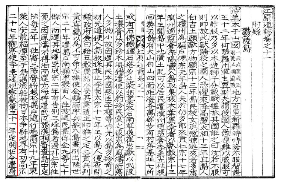
江原道誌 巻之十一 附録 鬱陵島 
・・・
〔位置及地勢〕 在蔚珍郡竹邊港東北海中三峰岌業撑空 南峯稍卑 風日清明 則峰頭樹木及山根沙渚 歴歴可見風便則二日可到全島絶壁周囲層岩峻急作三角形河川清冽原野雖少火山灰及腐植土甚肥沃距竹邊七十六浬東経一百三十度五分北緯三十七度三十分面積七千三百五十一町
------------------------------------------------

The Geography Text of Kangwon Province, Vol.11. Appendix Ulleungdo
・・・
(Location and Geography) It locates in the Northeastern sea of 蔚珍(Uljin)郡竹邊 harbour. Three peaks reach high into the sky. The southern peak gets gradually smaller. On clear, windy days, the trees on the summits and the sandy beaches at the base of the mountains are clearly visible. With a fair wind, they can be reached in two days. The whole island was surrounded by steep cliffs and covered by layers of rocks. The shape of the island is triangular. The clear rivers are running through the wild fields. Though there are not so much volcanic ashes and leaf molds, the land is fertile. It is 76 sea miles apart from 竹邊. It locates at the 135° 5′ E and 37° 30′ N. They have an area of 7351 cho (72.9 k㎡).

Actually, there is no mention of Usando at all in the sentence unlike other old documents, this time. So they are undoubtedly talking about the visibility of Ulleungdo from peninsula, that's for sure. It flatterly debunks Korean claim that the distance being talked about in the passage below from Geography Text of Korea's King Sejong (1454) was the distance between the two islands (Ullegungdo and Usan) rather than the distance between Uljin and the two island. The Korean translation is simply wrong if you read whole text.

于山武陵二島 在縣正東海中 二島相去不遠 風日淸明 則可望見 新羅時 稱于山國 一云鬱陵島. 地方百里
-----------------------------------------------------
The two islands of Usan and Mu-leung are in the sea due east of the present "hyeon" (Uljin), and the distance between them is close enough that they are visible on a clear, windy day. In the time of Silla, they were called Unsan-guk or Ulleungdo. It has an area of 100 ri.
This is also supported by almost all other Korean old documents which states about the visibility of Ulleungdo. For example, Sinjeung Dongguk Yeoji Seungram (新增東國輿地勝覽) (1530) also states that the islands of Usando/Ulleungdo (于山島 鬱陵島) were visible from the east coast of Korea. The text is almost same with Geography Text of Kangwon Province(1940), though Usando was described as same island as well.

于山島 鬱陵島 一云武陵 一云羽陵 二島在縣正東海中 三峯岌嶪撑空 南峯稍卑 風日淸明則峯頭樹木 及山根沙渚 歷歷可見 風便則二日可到 一說于山鬱陵 本一島 地方百里---------------------------------------------------------------------------
Usando/Ulleungdo are also called Muleung (武陵) or Uleung 羽陵). The two islands are in the sea due east of this village (Uljin). Three peaks reach high into the sky. The southern peak gets gradually smaller. On clear, windy days, the trees on the summits and the sandy beaches at the base of the mountains are clearly visible. With a fair wind, they can be reached in two days. It is said that Usan/Ulleung were originally one island. They have an area of 100 ri.

Second point is, it states that the early immigrants are mainly from 江原慶尚両道, not 全羅南道 as some pro-Korean claim.

〔沿革〕 ...(高宗)三十一年定開拓令置島長自是江原慶尚両道沿海民多移住者光武四年改為鬱陵郡置郡守隆煕元年移属慶尚南道併合後大正三年移属慶尚北道四年改郡守為島司 --------------------------------
(History) ... In the year of 31 (of King Kojong)(1894), the order of development was issued. The head of island was appointed and coastal residents of both 江原 and 慶尚 province mainly immigrated. In the 4th year of 光武(1900), it was determined as Ulleungdo County and the County Magistrate (郡守) was appointed. In the first year of 隆煕(1907), the administration was moved to 慶尚南道, and after the annexation, it was again moved to the 慶尚北道 in the 3rd year of Taisho(大正)(1914). And the "County Magistrate" was changed to "Island Magistrate(島守)".

Thirdly, it states that Usan was an old name for Ulleungdo. This is the only opportunity the name of "Usan" was mentioned in the text. "Usan" or "Usando" had been actually a name for Ulleungdo itself until Joseon Dynasy started to send official inspectors and gained more information around Ulleungdo in the late 1600s. Before that, Korean were not perfectly sure if there even really exit two islands. After the inspection, Inspector Bak Seok-chang (朴錫昌) made the map of Ulleungdo (鬱陵島圖形) 1711 and placed Usando(=Jukdo) right east to Ulleungdo with a label, "So-called Usando, Grove(s) of Haejang Bamboo (所謂于山島 海長竹田)". It crystellized the conception that Usando was Jukdo, 2.2 kilometers off the east shore of Ulleungdo and almost all the Korean maps started to place Usando to the east of Ulleungdo. Before that, the location of two islands were confusional and "Usando" and Ulleungdo were recorded to be one island with different names / Two different islands in many Korean old documents. This historical coufusion remains even in official documents for a long time.

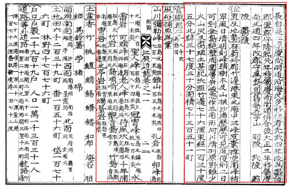
〔舊(古)島名〕 于山 羽陵 武陵 蔚陵 鬱陵
---------------------------------------------------------
(Old Name of Uleungdo) Usan, Ulleung, Mulleung, Ulleung, Ulleung

Lastly, as I already mentioned above, though the text mentions 観音島 and Jukdo(竹島/竹嶼) in the section of "山川(Mountains and Rivers)", but not Dokdo, Usando nor Seokdo or any other name Korean claim other names for today's Takeshima/Dokdo.

〔山川〕弥勒峰 在島北海抜七百一米突 錐山 在島北海抜四百五十米突 孔岩 在島北 卵峰 在島北海抜六百十一米突 聖人峰 在島北海抜九百八十四米突 冠冑峰 在島北鎮山海抜七百米突 水雷岩 可頭峰 倶在島西海邊 老人峰 在島北台霞洞 待風坎 在島北玄圃西 千年浦 在島北羅里 竹岩 在島北天府北 島項嘴 在天府東海濱 観音島 在島東海濱
---------------------------------------------------------
(Mountains and Rivers) Maitreya(弥勒) peak locates at the north of the island with 701m of the sea level. A Gimlet Mountain locates at the north of the island with 450m of the sea level. 孔岩 locates at the north of the island. Egg peak locates at the north of the island with 611m of the sea level. A Saint peak(聖人峰) locates at the north of the island with 701m of the sea level.

After the name "Usando" started being officially dropped from Jukdo and the name of Jukdo, Ulleungdo's neighboring island, which is only 2 kilometers off Ulleungdo's east shore, was officially recorded as Jukdo(竹島) by inspector 李奎遠 in 1882, right after Kitazawa Masanari(北澤正誠), a Japanese official of MOFA concluded that "竹島(Takeshima)" is Jukdo in 1881, "Usando", the old name for Jukdo, somehow started wondering again among Korean residents on Ulleungdo and they lost the location of "Usando".

This confusional naming shift around 1900 gave space for today's Korea's illogical claim "Usando was an old name for today's Takeshima/Dokdo", not Jukdo nor Ulleungdo, in addition to the name confusion by Japanese in Meiji due to the introduction of mismapped two Uleungdos in western maps, plus Japanese' newly giving Liancourt Rocks a name of Takeshima(竹島), which is the same Chinese as Korean Jukdo. But if the name "Usando" really didn't mean Jukdo, Korean in early 1900s must have named other islets around Ulleungdo or Takeshima/Dokdo as Usando, but they didn't, in reality. It practically means Usando didn't mean any other islets around Ulleungdo, except for Jukdo. Korean gave Takeshima/Liancourt Rocks, which Japanese introduced them in 1900s, a new name "Dokdo(独島)", which means "Sole/Lonely island", instead. The meaning of the name itself debunks Korea's claim that the Takeshima/Dokdo have been considered to be Ulleungdo's neighbouring island.

Those historical facts also tell us that Usando was almost certainly the old name for Jukdo(竹島 : Japanese write as 竹嶼), not today's Takeshima/Dokdo.

A lots of thanks to GTOMR for showing this important document.

1941 江原道誌 巻之十一_21941 江原道誌 巻之十一_3

References;

Q 2: What is Ulleungdo's largest neighboring island?

Q 3: Why did old Korean maps show Ulleungdo as two islands?

Q 4: Did King Sejong's geography text mention Dokdo?

Q 5: Did Korea's 1530 "Sinjeung Dongguk Yeoji Seungram" mention Dokdo?

1694 - Jang Han-sang (張漢相) Finds Sambongdo (三峯島)

1711 - Bak Chang-seok's (朴昌錫) Map of Ulleungdo (鬱陵島圖形)

1807 - May 12 - Lee Tae-gun (李泰根) Inspects Ulleungdo (日省録)

1881 - Kitazawa Masanari(北澤正誠), a official of MOFA concluded that
"Takeshima" is Jukdo in "A Study of Takeshima (Takeshima Kosho 竹島考証) "


1882 - April 7 - King Kojong says Usando Neighboring Island of Ulleungdo (高宗 19卷, 19年 4月 7日 壬戌)

1906 - July - Korea Omits Dokdo from Uldo County (皇城新聞 「鬱島郡의 配置顛末)

1913 - June 22- Location of Usando Unknown in Early 1900s (毎日申報 "無人島探検中止")

1918 - Japanese Map of Ulleungdo (鬱陵島図 朝鮮総督府)

22.10.08

1863 Korean Map from Japanese Woodblock Encyclopedia

This map is from a Japanese woodblock encyclopedia called "Edo Daisetsuyo Kaidaigura" (江戸大節用海内蔵) which was published in 1863, the 3rd year of Bunkyu. It contained a map of Korea which was titled as "Map of Chosun Country" (朝鮮国図), although we have no detailed information who made this map etc.
Please look at the map (click the map to enlarge). There is Ulleungdo "欝陵" at off the coast of 江陵 with three tiny islets around it, and you may notice a larger island at the north of Ulleungdo and it labelled as "Usando". This Usando is apparently different from Liancourt Rocks in the location, shape and size. It maybe an imaginary island which Korean people believed to be present.
The map resembles the Map of Joseon which Kaneganese introduced before in the following post:
It seems possible that the mapmaker for the 江戸大節用海内蔵 referenced the map. According to Kaneganese's investigation the woodblock encyclopedia had been revised for many times and the oldest version was published in 1704. So it may have been a common knowledge among Japanese people that Usando was a larger island at the north of Ulleungdo.
By the way, Korean scholars insisted that Usando (Josando) in the map in the formar post was Liancourt Rocks. But this can't be true if one thinks with a commonsense interpretation.

21.10.08

1904 Canadian Business Map of Japan

This is a large 1904 Map of Japan. It is from the Canadian version of Rand McNally Business Atlas. This atlas is very scarce as it was published for the purpose of shippers and businesses to get their goods to markets.


Please notice that the map was published in 1904, just before the incorporation of Liancourt Rocks (Takeshima) to Shimane prefecture of Japan, and four years after the Korean Edict #41. This is just an example of how the people of the world, especially international merchants and businessmen, looked at Japan and the islands in the Sea of Japan in those days.

Liancourt Rocks can be seen as Japanese territory. [Please click the left map to magnify] Also Taka Island (Argonaut island, a phantom island) and Matsu Island (Dagelet island, true Ulleungdo) were shown as Japanese territory. Although Matsu Island (Ulleungdo) was maistakenly depicted as Japanese island, maybe because of its Japanese name, it is important to know that Liancourt Rocks were not recognised as Korean territory. The same goes for many other western maps, I haven't seen a western map at all that depicted Liancourt Rocks to be Korean territory in late 19th century or in early 1900's. It maybe because it was a common sense in the world in those days that Korean eastern limit was Ulleungdo. It was also a common sense to Korean people as various geographical books, including Korean books, show.
So the Korean claim that they had Liancourt Rocks (Dokdo) before Japan's incorporation can't be true. Logical thinking may bring us to the conclusion that Seokdo in the 1900 Edict was not Dokdo.


1905 - June 5 - Tokyo Asahi Shimbun Corrected "Liancourt Rocks" as "Takeshima"

Prof.Shin Yong-ha(1997) (cache) and other pro-Korean claim that Japanese government and Newspaper conspired to "keep secret" and "not to publish the fact Takeshima was formally incorporated into Shimane" in official gazette nor newspapers so that many Korean and other foreigners in Tokyo could not know the incorporation. But Tokyo Asahi Shimbun(東京朝日新聞), the former name of the Asahi Shimbun, which was one of the most popular newspapers in Japan and the paper reported a circulation of over 100 thousands copies on weekdays already in 1900, actually made correction of the name of the island from "Liancourt Rocks" in 30th May to "Takeshima" in 5th June, following the correction article of Official Gazette on a same day. Obviously, it was no secret for Japanese government nor newspaper at all and apparently the fact that Liancourt Rocks was now Japanese Takeshima was easily accessible to all the foreigners including many Korean in Tokyo.

According to Prof. Shin's delusional "conspiracy theory", "Japanese government didn't allow newspaper to publish the fact so that the "secret" could be kept from many Koreans rediding in Tokyo at the time". In other words, if Official Gazettes corrected the name of the island and newspapers like Tokyo Asahi Shimbun, one of the largest newspaper printed the corrected map clearly indicate Liancourt Rocks was now Japanese "Takeshima", Korean definately had noticed about the incorporation of so-called their island. Korean always say that Korea had no chance of protest since it had no diplomacy in 1906, but there were no trace of protests against these official gazettes and newspapers in spite of it was way before the the Second Korea-Japan Agreement (referred to in South Korea as the "Ulsa protectorate treaty") in November 1905, based on which Japan seized diplomatic sovereignty over the old Empire of Korea.

In fact, according to Prof. Shin, in October 1905, Korean did protest against Japanese when they noticed a Japanese tried to own the Korean land (江原道蔚珍郡竹辺浦), where Japanaese Imperial Navy built the watchtower and later removed it just like Takeshima. And Korean government succeeded in bringing back to Korea in April 1906 !! What about Takeshima/Dokdo? Why they didn't even made protest against Japanese active effective control on Ryanko-to(Takeshima/Liancourt Rocks) in early 1900's - 1905, in which Japanese had been hunting Sealions freely with some Korean hired, Navy investigating, building watchtowers and tearing down later or even after they finally found out that it was officially incorporated into Shimane in March 1906, just like they did to the land in 竹辺浦?

So, why Korean in Tokyo who were supposed to have read this newspaper and official gazette didn't protest the incorporation at all? The only answer is, well, very simple, I suppose, that Korean didn't considered it to be their territory at all. It is positively supported by the fact that in the June 2 edition of Korean newspaper "Hwangseong Shinmun"(皇城新聞), Korean actually called Liancourt Rocks as "Angohu島(island)=Liancourt island" which was same with Japanese called it, not Dokdo, Seokdo, Usando nor any other names Korean claim to be the old names for Takeshima/Liancourt Rocks afterall, and the fact in July 1906 Edition, they reported that Ministry of Interior officially replied to Japanese Govenor-General that Takeshima/Dokdo was out of Uld County , too.

(A lots of thanks to matsu, who told me where to find newpapers and Prof. Shin's article, and providing Japanese translations for us.)

Reference
1905 - May 30 - Tokyo Asahi Shimbun

1905 - June 05 - Tokyo Asahi Shimbun

1905 - January 28th: the decision to incorporate Takeshima in to Shimane by a Cabinet meeting公文類集第29編 竹島編入閣議決定)

1905 - May 29 , 30 & June 5- An Extra of Official Gazette "The War Report of The Japan Naval Battle"

1905 - June 2 - 皇城新聞 : Korean called "Liancourt Rocks(リアンコルド岩)" as "Angohu島", not "Dokdo", Seokdo nor Usando.The 15th column " South Korea's
Groundless Claim of "Ingerent Part of (Korean) Territory"

1906 - July - Korea Omits Dokdo from Uldo County (皇城新聞 「鬱島郡의 配置顛末)

20.10.08

1905 - May 29 , 30 & June 5- An Extra of Official Gazette "The War Report of The Japan Naval Battle"

To follow are the war reports of the Japan Naval Battle(日本海海戦), as known as The Battle of Tsushima (Strait), printed in the extra of official gazette(官報号外) in May 29, 30 and June 5, 1905.

There are two important points we should notice here. Firstly, Takeshima(竹島) was written as "リヤンコールド岩(Liancourt Rocks)" and "リアンコルド岩(Liancourt Rocks)" in the article no.3 and 5, respectively, even though this is the official report from Fleet Admiral Marquis Togo Heihachirou (東郷平八郎). It is apparent that
none of Admiral Togo and his general staffs didn't even think of the new official name of the island and the incorporation of Takeshima(Liancourt Rocks) into Shimane determined by the Cabinet 4 month ago. In other words, for Japanese Imperial Navy, the whole process of the incorporation and the new naming of the island, regarding the question of the title to Takeshima/Liancourt Rocks, had nothing to do with their strategy of the Japan Naval Battle.

Pro-Korean scholars like Prof. Shin Yong-ha, Professor Emeritus Naito Seichu and Prof. Hosaka Yuji claims that "The fact that bureaucrats in responsible position in the government then lead the fishermen and worked up the incorporation of Dokdo/Takeshima by Imperial Japan into its own territory in order to win the war against Russia." "Especially, though those bureaucrats (Yamaza Enjiro(山座円次郎), the director of the state affairs of MOFA, Maki Naomasa(牧朴真), the director of the fishery division, Ministry of Agriculture and Economy, Kimotsuki Kaneyuki(肝付兼行) , a chief of Hydrograhical Department, Ministry of Navy) was in a position that are well aware of the fact that Dokdo/Liancourt Rocks is Korean territory, they apparently maneuvered the incorporation of the island into Shimane forcibly."  However, there are no such "facts" as they say, at all, in fact. In addition, as this war report shows, it doesn't make sense that Commander-in-Chief of the Japan Naval Battle, Admiral Togo, who was in charge of the whole Japan Naval Battle, and his general staffs didn't even use the official name "Takeshima" newly determined by the "maneuvering" incorporation, if it is true that Meiji government and bureaucrats including the chief of Hydrograhical Department, Ministry of Navy really had such a detailed plan to incorporate the island for the purpose of the victory of the Japan-Russo war. It is apparent that Japanese Navy didn't take the issue of the title of the islands, such as Takeshima and Ulleungdo, into account seriously enough from the strategical point of view.

To begin with, Japan-Korea Protocol (Japanese Original) was already signed in 1904 and by the second issuer of the article 4, it allows Japanese government to use Korean territory freely for the purpose of military strategy. In other words, there is absolutely no necessity for Japanese government to incorporate any Korean land into Japan, hence it is apparent that sovereignty of those islands has nothing to do with the accomplishment for the victory over the Japan-Russo War. If "villainous Imperial Japan" really incorporated Takeshima into Shimane knowingly that it is Korean land, as today's Korean claims, why they didn't seize and incorporate Ulleungdo, which is far more important and valuable than Takeshima geographically and economically? What about other islets which Japan built watchtowers on, just like Takeshima? Even though lager numbers of Korean were living on Ulleungdo then, it was "vacant island" until 20 years ago, and there were more than 300 Japanese were actually living on Ulleungdo. Besides, Japanese did had effective control over the Ulleungdo during 1600s until Joseon government protested.

Secondly, in the last part of 5th June gazette, it corrected the name "Liancourt Rocks" to "Takeshima". This is the concrete evidence that reject flatly Korea's claim that the process of the incorporation was done "secretly" in 1905. According to Korean Prof. Shin, there were many Korean residents in Japan, especially, Tokyo, at the time, so it was easily accessible to those Koreans. In fact, Korean media like 皇城新聞 actually reported the contents of the report three days later, which is the translation of this war report, and it means Japanese official gazette was accessible to Korean directly or at second hand at least. If Japanese government really wanted to keep the incorporation secret from Korean, they shouldn't had allow Shimane prefecture to publish the news that Takeshima was officially named as "Takeshima" and that it came under the jurisdiction of the Okinoshima branch, or have informed the Okinoshima branch to this effect. These measures were carried in the newspapers of the day and were broadly publicized. Not to mention, they wouldn't have published in the official gazette the announcement of the correction of the name of the island which they wanted to keep "secret".

Pro-Korean like Mr. Park Byeong-seop(朴炳渉), a permanent Korean resident in Japan, who works for Korean government's Dokdo research center as a consultative committee member and the distributor of "Half-moon's newsletter", only discuss about the misuse of the name "Liancourt Rocks" in No.3 and No. 5, thoughtlessly said "Maybe, Ministry of the Navy and the government organ, which publish official gazette didn't know that Takeshima had already been incorporated into Japan and must have took it as a foreign territory. It is understandable, since the incorporation was executed "secretly" at the governmental level, that they didn't know the fact. " The territorial claim, based on such an arbitrary translation of selective resources which are favourable only to him, could become not only a factor which may obstruct normal Japan-Korea bilateral relation, but also a factor which would aggravate antipathy towards Zainichi Koreans, including himself, in Japan. He should stop spreading those illogical claims, right now.
An Extra of Official Gazette 29 May, 1905 (original Japanese version )

War Report

War Report of the Japan Naval Battle  War report from the Admiral Togo Heihachiro, the Commander of the Grand Fleet(Combined Fleet), concerning for the Battle of the Sea of Japan, which has been undergoing since a day before (27th). (Ministry of Navy)

No.1 Received in the morning, 27th
Receiving the alarming that enemy vessel was seen, Grand Fleet put to sea instantly in order to beat this. Today, it is clear and fine, but swells high.

No.2 Received in the night, 27th
Grand Fleet crushed enemy fleet greatly near the Okinoshima today, and at least 4 enemy vessels went under water. We damaged other enemy vessels greatly. The damage of our fleet is small. The body of Destroyers and torpedo boats carried out attacking from sunset.

No.3 Received in the morning, 29th
Since 27th, the main force of Grand Fleet(連合艦隊) had continued running after the remaining enemy, and they faced and attacked, around Liancourt Rocks, the groups of the enemy vessels, Emperor Nikolai I(battleship), Orel(battleship), Senyavin(coastal battleship), Apraxin(coastal battleship), Izumrud(cruiser). Izumrud splitted and run away, but other fours surrendered soon after. Our fleet has no damages. According to the captives, the enemy vessels, which sunked during the battle on 27th, are Borodino(battleship), Emperor Alexander III(battleship), Zhemchug(cruiser).
The numbers of the prisoner of war sums up to 2,000, including Rear Admiral Nebogatov.

(Abbr.)

・・・・・・・・・・・・・・・・・・・・・・・・・・・・・・・・・・・・・・・・・・・・・・・・・・・・・・・・・・・・・・・・・・・・・・・・・・・・・・・

An Extra of Official Gazette 30 May, 1905 (original Japanese version )

War Report

Follow-up War Report of the Japan Naval Battle  War report obtained afterward from the Admiral Togo Heihachiro, the Commander of the Grand
Fleet(Combined Fleet), concerning for the Battle of the Sea of Japan. (Ministry of Navy)

No.4 Received in the afternoon today, 30th

The naval battle, which undertook between near Okinoshima and Ulleungdo from 27th to 28th May, is going to be called " the Japan Naval Battle(日本海海戦 : The battle of the Sea of Japan)" .

No.5 ibid.
As it was already transferred, the most of Grand Fleet had encircled and attacked the main force of remaining enemy ship corps, defeated near at the Liancourt Rocks in the afternoon on 28th, and after their surrender, it stopped the pursuing and now engaging the dealing with the aftermath. Meanwhile, around 3 o'clock, we found, to the direction of south-west, another enemy battleship Admiral Ushakov running north, so armoured cruiser Iwate and Yakumo pursued it instantly and called on it to surrender. However, it didn't respond. So we bombered and sunked it against our will. We rescued and accomodated the approx. 300 survivors. ....

(Abbr.)

・・・・・・・・・・・・・・・・・・・・・・・・・・・・・・・・・・・・・・・・・・・・・・・・・・・・・・・・・・・・・・・・・・・・・・・・・・・・・・・

An Extra of Official Gazette 5 June, 1905 (original Japanese version )
War Report

Follow-up War Report of the Japan Naval Battle 
War report obtained afterward from the Admiral Togo Heihachiro, the Commander of the Grand Fleet(Combined Fleet), concerning for the Battle of the Sea of Japan. (Ministry of Navy)

(Abbr.)


Correction

"Liancourt Rocks" in the third article of this column, which is a war report of the war report of the Japan Naval Battle on 29th last month, and in the fifth article of the follow-up report on the 30th, respectively, are both going to be corrected as "Takeshima(竹島)".

Referece
1905 - June 2 - 皇城新聞 : Korean called "Liancourt Rocks(リアンコルド岩)" as "Angohu島", not "Dokdo", Seokdo nor Usando.
The 15th column " South Korea's Groundless Claim of "Ingerent Part of (Korean) Territory"
Surely you are joking, Prof. Hosaka ! (ご冗談でしょう、保坂先生!)
1853-1922 - 肝付兼行 (Kimotsuki Kaneyuki)
1894年 - 海軍省水路部「朝鮮水路誌」(明治二十七年)

6.10.08

1905 June 15th: The Report of Takeshima (Liancourt Rocks) by the Captain of Hashidate

To follow is a report by the captain of naval ship "Hashidate", Fukui Masayoshi. The report is interesting because it mentioned that there were "several" barns (or huts) at Takeshima (Liancourt Rocks), not a single hut. And the barns were made by Japanese fishermen who lived there for the summertime. Food and water were supplied by a Japanese sailboat from Oki island once or twice a month, not from Ulleungdo. Although this report was made in 1905, they had kept this kind of seal hunting every year. This is one of the evidences that Japanese people controlled the islands in the early 20th century.
It is also very important to clarify that these fishermen were directly from Oki islands and they were supplied food and water from a ship from Oki islands, because some records mentioned that Japanese fishermen (hunters) went to Liancourt Rocks from Ulleungdo and pro-Korean scholars used to claim that "Japanese unlawfully stayed in Ulleungdo and went to Dokdo from Ulleungdo". But such a claim was not true.
The report also referred to Nakai Yozaburo (as Nakae Yozaburo) who made the petition to incorporate Liancourt Rocks. Nakai was the leader of the fishermen mentioned above.
http://dokdo-or-takeshima.blogspot.com/2007/06/petition-to-incorporate-ryanko-to.html

Also, for more information about the inspection by Hashidate, please read the following:
http://dokdo-or-takeshima.blogspot.com/2007/10/1905-jun-japanese-cruiser-surveys.html
..............


明治三十八年六月十五日橋立艦長海軍大佐福井正義ノ提出セル竹島視察報告


命ニ因リ明治三十八年六月十二日竹敷ヲ発シ十三日午後二時竹島東嶼ノ東端約一浬ニ達シテ漂泊シ即時端舟ヲ胤シ航海長小倉大尉及ヒ其ノ従属森田中尉ヲ派遣シ望楼設置適否ノ調査ヲ命ス 此ノ一行中ニハ豫テ佐世保鎮守府ヨリ派遣セル技手職工等ノ一行ヲ含有セリ右派遣将校ノ調査概要左ノ如シ


一、竹島ハ二座ノ列岩ヨリ成ル磽确不毛ノ小嶼ニシテ西方ニ位置スルモノハ大ニシテ且高シ(海面標高四百十呎)然レトモ四面皆断崖絶壁ニシテ攀登スヘカラス加之嶼上平坦ト認ムヘキ地ナク都テ峻険ナル岩峰屹立シ望楼設置ノ望絶エテナシ


東方ニ位置スルモノハ前者ヨリ稍低シト雖モ(三百二十五呎ヲ概測シ得タリ)峻険ノ度少シク緩ニ辛ウシテ攀登スルコトヲ得へク峡上皿状形ノ如キ稍平坦ナル地面アリテ多少ノ土工事ヲ施セハ造営物ヲ建設シ得ヘシ


一、建築材料ノ陸揚ケ竝ニ頂上ヘノ運搬ハ辛ウシテ為スコトヲ得先ツ陸揚場ニ就テ言ハンカ別紙見取略図ニ示スカ如ク東西ノニ嶼ハ四座ノ小立岩一條ノ礁脈ニ因リテ連結セラレ其ノ長サ約一鏈(水路誌ニハ二鏈半トアリ)礁上ノ水深二尋乃至三尋ニシテ優二小舟ヲ通スヘク叉四座ノ立岩ハ恰モ波濤堤ノ用ヲ為シ東嶼ヨリ西走スル突角ト相待テ小港ヲ形成シ小船舟ヲ繋継スルノ便アリ但偏西風二對シテハ全ク暴露シ船舟ヲ繋継スヘカラス


此ノ小曲湾ハ東嶼二對スル唯一ノ陸揚地點ニシテ濱岸小平地ニハ現二猟夫ノ結作セル数箇ノ納屋アリテ三十有餘人是二假住ス

山上へ材料ヲ運搬スルニハ「デリック」樣ノモノヲ以テスルヲ便利トスヘク断崖攀登ヲ要スル箇所ニハ策梯ヲ用フルモ亦一法ナランカ


一、西嶼頂上ヨリ落チ來ル一小流脈アレトモ鹽分多量ニシテ口ニスヘカラス且試験ノ結果到底飲料二適セサルコト別紙軍醫二依リテ為サレタル試験表ノ如シ


一、望楼員ノ副食二供スヘキ蔬菜培殖ノ如キモ無論不可能ナルヘシト信ス如何トナレハ峻上磽确ニシテ殆ト土壌ト名クヘキモノナク且降雨少ケレハナリ


以上ハ派遣将校ノ観察スル所ニシテ此ノ派遣中本艦ハ島ノ周囲約一浬ヲ隔テ一周ヲ試ミタレトモ別ニ暗礁等ノ觸目スルモノナカリヤ但東嶼ノ北東端ヨリ一鑛脈走出シ其ノ長サ約二鏈ト目測シ得タリ


本島ハ目下海驢(Seals)ノ獵季ニシテ隠岐國ヨリ渡來ノ獵夫(寧ロ漁夫ナラン)三十五六名二達シ小銃ト網器トヲ用ヒテ海驢ヲ捕フ其ノ獵獲ノ豊富ナル見ルニ足ルヘキモノアリ少時間ノ観察中彼等ヲ捉ヘテ談話セシ處亦参考ニ資スヘキ価値アルヲ以テ其ノ概要ヲ左ニ揚ク


本島ハ海驢獵ニ於ル一富場ニシテ獵者ハ陰暦四月中旬ヨリ七月中旬マテ駐在シ連日獵業ニ従事ス

海驢ヨリ得ル所ハ皮ト油トニシテ之ヲ大阪地方ニ送リ毎年ノ獲得金額四千圓乃至五千圓ナリト云フ

目下獵夫ノ指揮ヲ司ルモノハ隠岐國中江養三郎ナルモノニシテ本人ノ云フ所ニ依レハ若シ志願者アラハ本年ハ冬季モ駐在シテ本島ニ越年ヲ試ムルノ志願ヲ有スト

海驢ノ外少量ノ鮑ヲ収獲スト云フ

氣候ハ夏季ニ於テ日中酷暑ヲ感スルモ朝夕ハ極テ涼冷ヲ覺ユ最炎暑ヲ感スルハ舊六月ナリトス叉濕氣多クシテ降雨量ハ本土ニ比シ極テ少シ


附近潮流ハ北東流ナルカ如ク其ノ速力モ少ナカラス干満差ハ約四呎ナリ(報告者曰ク四呎ハ多キニ過タルカ如シト雖モ獵夫ノ言ニ謂フ故二姑ク疑ヲ存シ置ク)


本島ニハ薪水ナシ故ニ毎月一二回帆船ヲ以テ隠岐國トノ交通ヲ保チ糧食薪水其ノ他萬般ノ供給ヲ仰キ居ルト云フ


(別紙)

水分析表


臭 無シ     清濁及ヒ色 稍黄褐色僅微ノ浮遊殘渣

鹽素 多量    石炭 僅微

安母尼亜 多量   硫酸 稍多量

亜硝酸 無シ  硝酸 無シ

有機物 多量   摘要 飲料不適

Thanks to readers who helped me to read the old Chinese characters in the original document.


June 15th, 1905. The Report about the Inspection of Takeshima (Liancourt
Rocks) presented by the captain Fukui Masayoshi of the Naval Ship Hashidate

................

As I was ordered, we departed Takeshiki on June 12th 1905 and reached and
wandered at one nautical mile off east edge of the east islet of Takeshima (Liancourt
Rocks) at 2pm on the 13th. Soon we lowered a boat and dispatched the
chief navigator Lieutenant Kokura (or Ogura) and his attendant Lieutenant Junior
Grade Morita and made them investigate whether the installation of watchtower is
adequate or not. The party included a group of engineers and mechanics who were
dispatched by the Sasebo Naval Defense Office. To follow is the summary of the
investigation by the officers we dispatched.

............

● Takeshima (Liancourt Rocks) is a barren small island which comprises two rock islets. The rock islet at west is bigger and higher (410 feet above sea level), but the
circumference forms a
precipitous cliff and it is impossible to climb. There
is no flat space at the summit of the islet with towering steep rock peaks,
there is no hope to install a watchtower there.

The islet at east is slightly shorter than the former (it was measured as 325 feet). However, the slope is slightly gentle so that one can manage to climb up. There is a
slightly flat place just like a dish up there, it would be possible to build a house if we did a bit of construction work.

● The uploading and transport of building materials to the summit will be barely able. As to the uploading point, there is a good point as I showed a sketch on another sheet of paper. The two islets of both east and west are on a line along with four rocks
between them, the length of the line would be about one-ren (185 m) and the
depth of water on the reef between the islets would be 2 or 3 –hiro (3 or 4.5 m)
which would be easy for small boats to pass. The four rocks between the islets
work as if they were a breakwater and they form a little cove with a process of
the east islet which is protruding to west. One can moor boats there, although
it would be difficult when
westerlies blow.

This little cove is the one and only uploading point, actually there are several barns which were made by hunters (fishermen) and more than thirty people live in the barns
temporarily.

Something like a derrick would be convenient to transport materials to the summit, and it may be good to use a rope ladder to climb the cliffs.

●There is a little stream running down from the summit of the west islet but one cannot
drink it because it contains a lot of salt. After the examination by a naval surgeon, the water is not fit to drink at all as the examination result shows which was written on another sheet of paper.

●I believe that cultivation of vegetables for side dishes for watchtower officials would be impossible because the land is sterile and pebbly without soil and we have a few rain here.

..........................................................................................................

The above are from what the officials we dispatched observed. During the dispatch we tried to make our ship go around the islands with keeping one nautical mile off from the
islands and found no reef there. However, there was a vein of reef running from
northeast side of the east islet and its length seems to be 2-ren (370 m) by eye
measurement.

It is a hunting season of seals at present at these islands. The number of hunters (maybe fishermen rather than hunters) is 35 or 36. They have rifles and nets to catch
seals. It is worth seeing the
catching such an abundant seals. I caught some of the hunters and had a conversation with them while we stayed there for a short time, it was worth mentioning. To follow is the summary of the information.

.....................

These islands are one of the largest hunting grounds of seals. The hunters (fishermen) reside at this place from mid-April until mid-July by the lunar calendar and engage in hunting day after day.

The main products made from seals are skin and oil. They are sent to Osaka district, which makes \4,000 or \5,000 of money per year.

The man who directs the hunters now is a man named Nakae [sic] Yozaburo from Oki county. According to him, he would try to make some of the hunters pass this winter at
the islands if there would be volunteers.

They get a little of abalones in addition to seals.

As to the climate, although they feel terrible heat during the daytime in summer, they
feel coolness in the morning and in the evening. The hottest month is June by
the old calendar. It is moist but they have very few rain compared to the mainland.

The tide around the islands seems to be directed to northeast and flows rapidly. There is a great range of tides. The difference between the tidemarks is about four feet
(a reporter says that although it seems that four feet is too much but it was
hunters’ opinion so we have to keep it untouched).

They have neither firewood nor water in these islands. So they keep communicating with a sailing boat to Oki county once or twice in a month in order to be supplied
food, firewood, water and another things.

........................................

(Another sheet of paper)

Analysis of water

Odour: none. Turbidity and colour: slight yellowish brown, a little floating
leavings.

Clorine: much. Lime: a little.

Ammonia: much. Sulfuric acid: relatively much.

Nitrous acid: none. Nitric acid: none.

Organic matter: much.

Summary: Not fit to drink.


5.10.08

1905 June 14th: A Report of "Takeshima" (Liancourt Rocks) by Rear Admiral Taketomi Kunikane

After two days from the June 12th report by a naval engineer, the commander of the third fleet Rear Admiral Taketomi Kunikane reported about “Takeshima”, he didn’t use the name of Riyankorudo-gan in this report, although they were on the same naval ship. It may simply means that there was still some confusion concerning the name of Liancourt Rocks in the Navy. This report mentioned Japanese fishermen from Oki islands but no mentioning of Korean fishermen, which is one of the evidence that Japanese knew and used the rocks in the 1900’s. There were no traces of other countries’ occupation as the 1905 Cabinet decision announced.


http://dokdo-or-takeshima.blogspot.com/2007/11/28th-of-january-1905-dicision-by.html


明治三十八年六月十四日第三艦隊司令官海軍少将武富邦鼎ノ提出セル竹島視察報告


一、小官ハ第三艦隊司令長官ヨリ橋立ヲ率ヰ佐世保鎮守府ヨリ派遣セル建築科員ヲ便乗セシメ之ヲ竹島ニ送致セシムルト同時ニ同島ニ假設望楼設置方適否ノ判断ニ任スヘシトノ訓令ヲ受ケ十二日午後竹敷ヲ出發シ翌十三日午後二時着シ直ニ建築科員ヲ同島ニ送ルト同時ニ橋立艦長ニ命シ将校ヲ派遣セシメ之カ観察ヲナサシメタリ

二、艦上より観察スル所ト橋立艦長報告竝ニ建築科技手ノ報告トヲ綜合シテ東西両島ヨリ成ル竹島ニ假設スヘキ望楼建設ニ●シ左ノ意見開陳ス


(イ)西島ハ東島ヨリ稍高ク約四百十餘呎ナルモ四周断崖絶壁ニシテ到底攀登スル能ハス叉望楼ヲ設置シ得ヘキ餘地アルヲ認メス且視察當日雲霧其ノ頂上ヲ隠蔽シアリシニ從スレハ假令望楼位置ヲ其ノ頂上ニ置キ得ルトスルモ雲霧ナキノ日ニアラサレハ常ニ視界ノ妨害ヲ免レサルモノト推判ス

(ロ)東島ハ西島ヨリ稍低ク且小ナルモ尚高サ約三百二十五呎ニシテ頂上ニ近ク望楼建設ノ餘地アルノミナラス其ノ南方ハ稍斜面ヲナシ且西方ハ凹岸ニシテ小湾形ヲナス此ニ小舟ヲ附クルヲ得テ交通ノ便アリ唯望楼位置ヨリ方位西北西ヲ中心トシ左右ニ三十度位ノ間視界ヲ西島ニ遮断セラルルヲ憾ム然レトモ西島頂上ノ如ク雲霧ノ為メ隠蔽セラルルコトハ少キモノト信ス


以上ノ状況ニヨリ望楼建設ノ位置ハ東島ヲ以テ適當ナルモノト認ム


三、望楼ノ設計装置

望楼ノ設計装置方法ニ於テハ建築科技手ノ設計ヲ以テ適當ナルモノト認ム

右設計ニハ岩石ヲ掘リ下ケ望楼員詰所アリ其ノ内ニ水罐蒸留水器糧食薪炭貯蔵所アリ叉別ニ見張所旗竿(旗竿ハ起伏自由ノ装置)等アリ其ノ詳細ノコトハ此ニ略ス


四、望楼員生活ノ難易

(イ)竹島ノ如キ孤島ニ於テ生活ニ最必須ナルモノハ飲料水ナリ之カ供給ニ適応ノ蒸留器ヲ装備シ且数箇月分ノ糧食ヲ貯蔵セシメ而テ月ニ一回若クハ二回汽船ヲ派シ之カ補給ヲナサハ敢テ本島望楼員ノ生活ニ於テ左程困難ハアラサルモノト認ム 現ニ本邦ノ漁夫数十名同島ニアリテ海豹捕獲ニ従事シ居レリ其ノ言ニ從スレハ彼等ハ毎年五月中旬頃ヨリ八月中旬頃ニ至ルノ間毎月一回隠岐ヨリ和船ヲ以テ交通シ糧食ノ補給ヲ受ケ此ノ島ニ生活シ居ルト云フ

(ロ)初メ荒天ニ際シテ或ハ怒涛全島ヲ洗ヒ人類ノ住居生活ニハ適セサルヤノ疑念アリシモ今観察スル所ニヨレハ相當ノ設計ヲ以テセハ左程ノ困難ニアラサルモノト知了セリ


五、望楼員ノ保護

保護ノ點ニ於テハ望楼ノ建設ヲ堅固ニスルコト内地ト汽船交通ノ便ヲ計ルコト等ナリ唯洋中ノ一孤島ニシテ海上平穏ナル日アラサレハ小汽船ノ交通ハ随分困難ナルヘシ殊ニ冬季中日本海北風烈シキ季節ニ際シテハ一層ノ困難アルヘシ依テ此ノ季節ニ慮スルノ方法ヲ講シ以テ十分ニ之カ設備ヲ為スノ必要ヲ認ム


六、別紙見取図橋立艦長報告竝ニ建築科技手報告望楼豫定位置図ヲ添付ス

(編者曰ク橋立艦長及ヒ建築科技手ノ報告書ハ第六十七號及ヒ第七十號ニ掲ク)

To follow is a rough translation:


The report of inspection of Takeshima presented by the third fleet
commander, Rear Admiral Taketomi Kunikane on June 14th
1905.


1. I was ordered by the chief commander of the third fleet to give an architectural engineer from the Sasebo Naval Defense Office(鎮守府) a lift in our ship Hashidate as far as Takeshima and also to judge whether a plan of the temporal watchtower at the island is adequate or not. So we departed Takeshiki on the afternoon of the 12th. As soon as we arrived there at 2:00pm of the 13th, we sent the engineer to the island. At the same time I ordered the captain to send naval officers to inspect the island.


2. According to an observation from our ship along with the reports by the captain and by the architectural engineer, I would like to say the following concerning the building a temporary watchtower at Takeshima, which comprises of east and west islands.


(A) The west island is higher than the east island, it is more
than 410 feet high. The circumference of the islands is precipitous cliff and very hard to climb, and there is no room to establish a watchtower there. In addition, the summit of the island was obscured by cloud and fog on the inspection day – even if we could
build a watchtower at the summit, it is assumed that visibility would be always bad unless cloud and fog would disappear.


(B) The east island is shorter than the west island, but its height is still 325 feet high. There is a room to build a watchtower at near the summit, with a slope at south and a little cove at west where we can attach a boat for transportation. It is a pity that the visibility would be obstructed for about 30 degree at the west-northwest direction by the west island. However, I believe that it wouldn’t be obscured by cloud and fog like the summit of the west island.


Considering above, I recognize that the adequate place of the watchtower would be the east island.


3. A plan and devices of the watchtower

I recognize that the plan made by the architectural engineer would
be adequate. According to the plan, there would be a staff room which would be
made after digging the rock. And there would be a distillation apparatus in it
along with a storeroom for food, firewood and charcoal. There would be a
watch-house and a flag pole at another place. (The flag pole can be easily put
up or put away.) The details would be abbreviated here.


4. Difficulty of watchtower officials’ life

(A) The indispensable thing at an isolated island like Takeshima
is drinking water. I recognize that there would not be a big difficulty in
living for the watchtower officers if there would be a distillation apparatus
for drinking water, stored food for several months and a steam ship that would
come to supply things once or twice a month. Actually, dozens of Japanese fishermen
are staying here and engaging in hunting seals. According to them, they are
living here from mid-May until mid-August with a supply of food by a Japanese
ship which comes here from Oki island once in a month.


(B) At first, we assumed that this island would not be adequate
for humans to live because surging waves wash all over the island. But after the
observation I understand that if we plan adequately it would not so difficult to
live here.


5. Protection of the watchtower officials

As to the protection, we need to construct it firmly and need to
make the steam-ship transportation constantly to the mainland. As this is an
isolated island in the ocean and it would not always be calm, transportation
with small ships would be difficult. It would be more difficult particularly in
winter when north wind could be severe. So we need to consider how to cope with
this season and to equip enough.


6. Attached sheets are rough sketches, reports by the captain of
Hashidate and by the architectural engineer, and a sketch of the planned
location for the watchtower.

(Editors say that the report by the captain of Hashidate is published as #67 and the report by the architectural engineer as #70.)