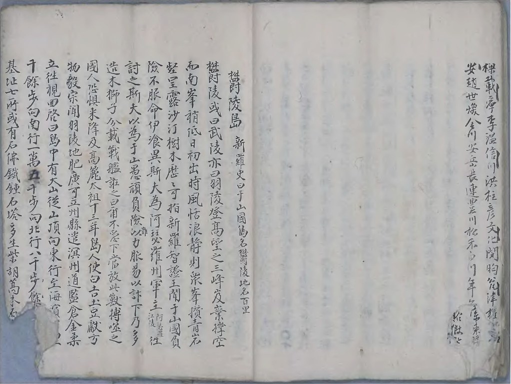
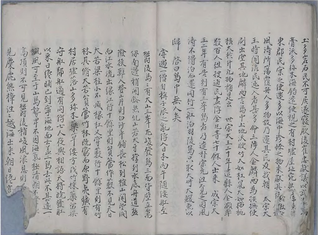
「到寧海地面云盖二島 去此不甚遠一颿風可至」鬱陵島と于山島の二島が朝鮮半島から遠くないことを明記した、この一文でおなじみの朴世堂『西渓雑録』に、張漢相の「蔚陵島事蹟」が引用されている部分があり、それが今まで知られてきた張漢相の外後裔、「申光璞」氏の書による写し〔1977/78年に発見された〕の記述と大きく食い違うことがGTOMR氏によって指摘されました。張漢相の「蔚陵島事蹟」自体、1693年~1696年に起こった一連のいわゆる竹島一件において朝鮮王朝がこれを元に日本側に何か、特に竹島、さらには松嶋の領有権を主張することはありませんでした。また、申光璞版の「蔚陵島事蹟」は、それまで朝鮮側には、欝陵島に関する知識が十分でなかったこともあり、記述が錯綜としています。朴世堂版の記述は申光璞版に比べてより詳しく、"丸い円を最初に書いて、此の文章どおり読んで記入していくと、全く同じ地図ができる”が、申光璞版では同じように書いていっても地図が完成しない、とのGTOMR氏によるご指摘もありました。(matsu氏も「(申光璞版は)テキスト全体をみると、内容が前後するところがあり、あるいは錯簡があるのかもしれません。」との感想を述べていらっしゃいます。)また、GTOMR氏のいう”別の文書の張の報告の引用、および他の捜討官は皆「可支魚」を報告しているのに、此の文章では「鮫魚」に改竄されている事”という、申光璞版の内容の信憑性への疑問、さらに書写年代の不明も大変気になるところではあります。
以下に、お二人による各版の書き起こしを掲載し、漢字の解読を進めたいと思っています。また、文の内容等について皆さんのご意見を頂戴したいと思っています。よろしくお願いいたします。(「」内はchaamiey氏による解読。(「」)になっているものは、GTOMR氏との読みが違う部分です。)
なお、この投稿は検討の結果を反映して後日大幅に書き換える予定です。書き換えの記録は、コメント欄をもってかえさせて頂きたいと思っています。
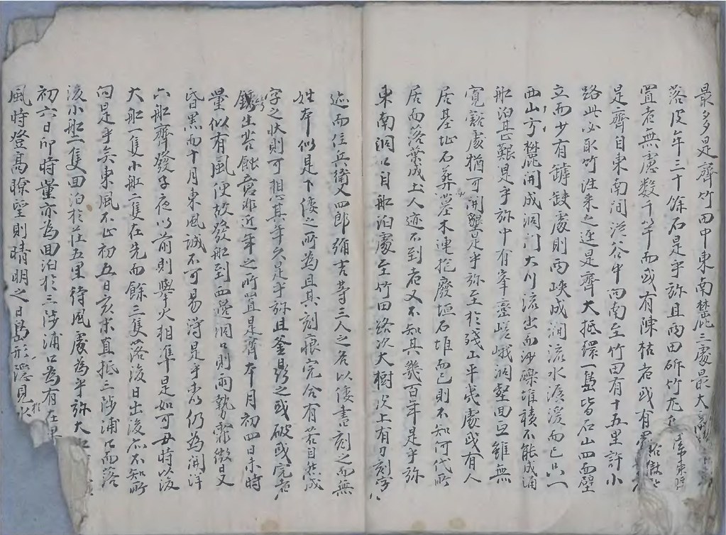
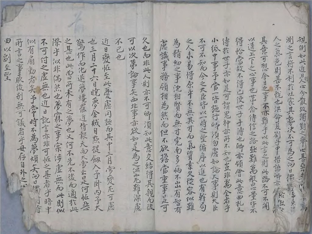
朴世堂『西渓雑録』
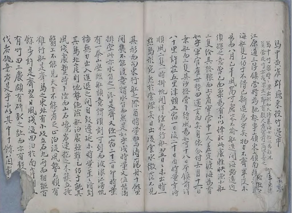 (3-1)江原道三陟鎮営将為馳報事
嶺東嶺南既<??>
(3-2)海舡隻乙仍于不得己新造為乎矣 物力不齋畢得未
(3-3)易而
八月已半風高可慮?不喩舡造間海路遠近
(3-4)偵探之意曽己面禀為有■擇取此處軽快漁小船
(3-5)二隻給其格粮而土着軍官中一人差定渡海為有
(3-6)如乎軍官
崔世哲回還言内矣身依分付
去月十六日(3-7)乗船而二隻其沙格営下待風為如可
十八日本鎮前洋
(3-8)八十里許荘五里津頭止宿一日後
二十日酉時量幸将
(3-9)順風二隻一時掛帆開洋経夜行船
翌日日未出時一
(3-10)点島形宛然於雲際矣日出後雲水徴茫不見
(3-11)其形而向東行舡之際
酉時量驚涛蕩舟十餘里
(3-12)間幾不能渡意謂水臽
而然是如乎
戌時量又値怒涛
(3-13)排空此亦水臽之一派是齋又経一宿
二十二日卯時量
(3-14)有一泰山壁臨舡頭意謂頃刻可到而波浪汹湧帆
(3-15)播無力出入進退之間自致遲延未時量菫菫涛到
(3-16)
其島北岸則地勢絶険船舶所極難乙仍于就其
(3-17)風残
處暫時下陸而山石巉岩連抱之木簇立掩
(3-18)翳上不能見天下不能着之止泊後風勢不順有
(3-19)難行舡是
齋島之東北有小岐立石九所而相距百
(3-20)
餘歩許是齋
翌日風残■回泊於南岸則
(3-21)有竹田三所頗有伐取之跡而亦有数<???>
(3-22)伐者抛棄者是乎■其中十餘箇載<???>
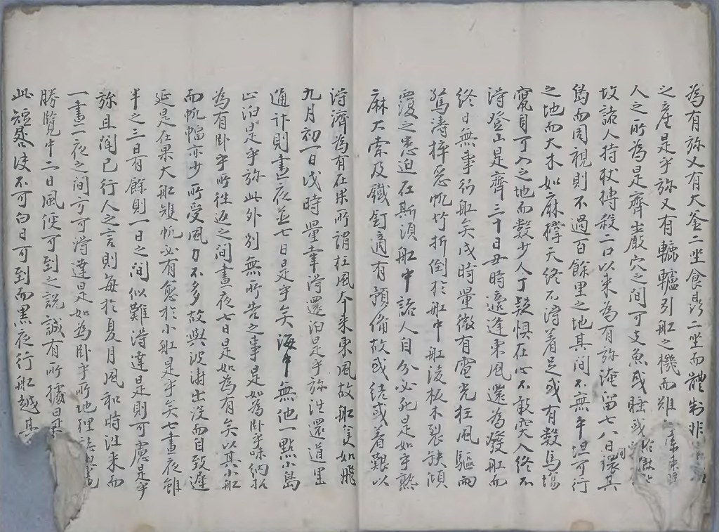 (4-1)
(4-1)為有於又有大釜ニ坐食鼎ニ坐而體●非<??>
(4-2)之産是乎於又有轆轤引舡之機而難<???>
(4-3)人之所為是齋
巌穴之間可支魚或●<??>
(4-4)故諸人持杖搏殺二口以来為有淹留
七八日還間
其
(4-5)
島而周視則不過百餘里之地其間不無平坦可行
(4-6)之地而大木如麻撑天終不得着之或有数馬場
(4-7)究自可入之地而数少人丁●惧在心不敢突入終不
(4-8)涛
登山是齋
三十日丑時還逢東風還為発舡而
(4-9)終日無事行
舡矣戌時量徴有電光強風駆雨
(4-10)驚涛捽悉帆竹折倒於
舡中舡渡板木裂缺傾
(4-11)覆之患迫在斯須舡中諸人自分必死此是如乎熟
(4-12)麻大索及鉄釘適有預備故或結或着艱困難以
(4-13)●済為有在果所謂柱風夲来東風故舡隻如飛
(4-14)
九月初一日戌時量幸●還泊是乎於往還道里
(4-15)通許則晝夜並
七日是乎矣
海中無他一點小島(4-16)止泊是乎於
此外別無所告之事是如為?乎味納於
(4-17)為有臥乎所往返之間晝夜
七日是如為有矣以其小舡
(4-18)而帆幅亦少所受風力不多故輿波涛出没而自致遅
(4-19)延是在果大舡矱帆必有愈於小舡是乎矣七晝夜雖
(4-20)半之
三日有餘則一日之間似難涛達是則可慮是乎
(4-21)於且聞已行人之言則毎於夏月風和時往来而
(4-22)一晝二夜之間方可●達是如為臥乎所
地理誌輿地
(4-23)
勝覧中二日風便可到之説誠有所據是<???>
(4-24)此短使不可白日可到而黒夜行舡越其<??>
 (5-1)
(5-1)所着則漂流可慮是齋所謂已斫之大竹<??>
(5-2)来為有去乙取而視之則無異於
西南 進上<??>
(5-3)大小是乎於且見所謂殺得
以来之可支魚則<??>
(5-4)之輿海狗班獺同類而異名者也
平海通川等地
(5-5)多有其種云元非稀貴之物是齋苧枝竹蓋叢●
(5-6)蒨於原濕之間云可想曩時人居之址是乎於
(5-7)釜鼎之排置者似是
倭人殺得可支魚處取其油(5-8)而抛棄之物也且聞鈹生苔蝕已至剥落之似非近
(5-9)年之所置而彼人之不常来往據此可想是去乎
(5-10)浅慮如是惶恐敢陳是齋舡後則一両日間可
(5-11)以畢後是乎所待風発船計料緑由並以馳報
(5-12)為臥乎事
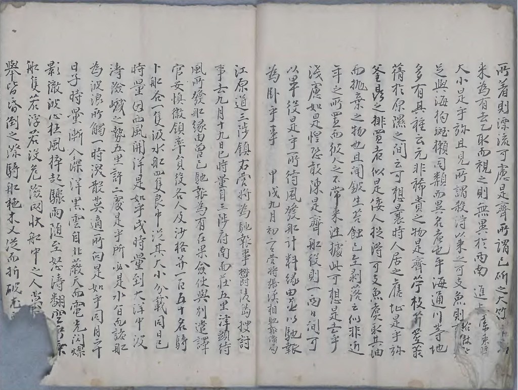
甲戌九月初二日営将張漢相馳報備局(5-13)
江原道三陟鎮右営将為馳報事鬱陵島捜討伐
(5-14)事
去九月十九日巳時量自
三陟府南面荘五里津頭
待(5-15)
風所発船縁由曽已馳報為有在果検使輿別遣譚
(5-16)官
安慎徽領率員役各人及沙格併一百五十名騎
(5-17)ト舡各一隻汲水舡四隻良中従其大小分載
同日巳
(5-18)
時量因西風開洋是如乎戌時量到大洋中波
(5-19)涛険峨之勢五里許二処是乎所必是水●而諸船
(5-20)為波浪所觸一時?散莫適所向是如乎
同月二十
(5-21)
日子時量漸入深洋黒雲自北蔽天而電光閃爍
(5-22)影徹波心狂風捽起驟雨堕至怒涛翻空<●●>
(5-23)船隻若浮若没危険
網状
舡中之人莫<不失措>
(5-24)拳皆昏倒之際騎舡舵木又従而折破<●無制船>
 (6-1)
(6-1)之望西強以櫓木直挿於船尾及左右<借以為力>
(6-2)是呼乃覆没之患迫在斯須是如乎風<風
雨漸息>
(6-3)天又向曙而島在北方水勢東往故船中之人<因此>
(6-4)甦醒盡力櫓役輾轉向島巳時量艱到島之南
(6-5)岸繋纜石角暫時下陸炊飯之際汲水船四隻自
(6-6)南洋稍々来到而卜舡叚不知所向是如乎酉時量
(6-7)又自南洋西至各舡倶涛免恙南岸無可舡泊
處
(6-8)己仍乎同日初昏回泊于東南間洞々内也宿渡
自(6-9)
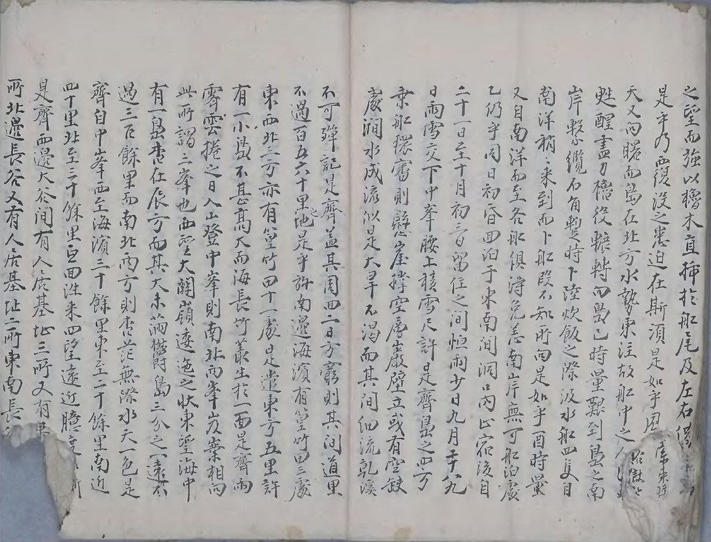
二十一日至十月初三日留住之間
恒雨少日九月二十八九(6-10)
日雨雪交下中峯腰上積雪尺許足齋島之四方
(6-11)乗船環審則懸崖撑空層巌壁立或有空缺
(6-12)處澗水成流以是大旱不渇而其間細流●渓
(6-13)不可弾記是齋蓋其周
回二日方窮則其間道里
(6-14)
不過百五六十里之地是乎於
南邊海濱有篁竹田三所
(6-15)
東西北三方亦有篁竹田十一処是遣
東方五里許(6-16)
有小一島不甚高大而海長竹叢生扵一面是齋両
(6-17)
霽雲棬之日入
山登中峯則南北兩峯岌嶪相向
(6-18)此
所謂三峯也西望大関嶺逶迤之狀
東望海中
(6-19)
有一島杳在辰方而其大未満欝島三分之一遠不
(6-20)
過三百餘里而
南北西方則杳茫無際水天一色是
(6-21)齋
自中峯西至海濱三十餘里東至二十餘里南近(6-22)
四十里北至三十餘里互回往来四望遠近臆度<●●●>
(6-23)是齋
西邊大谷間有人居基祉三処又有<●●●>
(6-24)所
北邊長谷又有人居基祉二所
東南長<●●●>
 (7-1)
(7-1)居基址(地)ニ所
西南間大谷有基址(地)七所石葬<●●●>
(7-2)是齋
舡泊處則
東南間洞々厪容四五隻<之䖏>
(7-3)地而東南風則亦非可藏可●䖏是遣此䖏<有>
(7-4)釜二鼎而二釜一鼎則破傷釜鼎軆樣
非我國(7-5)
之制也鼎則無足無盖其大可炊二斗米釜則廣經
(7-6)尺許深可二尺容盛水五六桶是齋
西邊大谷溪澗成
(7-7)
川沿邊開豁此處為最而所
泊舡處可避東南北
(7-8)風而西風則難避之非船泊之所而又有又有一鼎可容
(7-9)斗米之炊而●是彼物是乎於
北邊浦岸上有
轆
(7-10)
轤亦
非我人所造是齋島中
崗巒重疊而山腰
(7-11)
以上則皆是石角腰下則土山而山勢絶險洞壑深
(7-12)邃連抱樹木參天而蔽日者不知幾其許●不喩
(7-13)積年空棄之地人遮不到故藤葛磐結有難排
(7-14)擠卒非人力之所可通逕小小澗谷不暇窮探是齋
(7-15)所謂樹木盡是冬栢紫檀側栢黄蘗金椢木嚴
(7-16)木槐木椵木桑楡楮椒楓檜樹栢之類而其中
(7-17)冬栢紫檀最多是乎於松木真木欅橡小木暇
(7-18)終無一株而羽則鳥鷗毛則柚兒而已此外他無飛走
(7-19)之屬是乎所既無人居又無木宲可食而然是乎喩
(7-20)亦甚可怪是齋
水族則只
有可支魚而
沿邊石堆處
(7-21)或十或百成群穴居大如駒犢小如犬豕是乎於間有
(7-22)生鰒之附諸山名磧者軆小而味薄是齋
四方浦邊(7-23)破船板木片片漂着者處處有之而或<鉄釘>
(7-24)或着木釘或有腐傷者而
東南崖<●●●>
 (8-1)
(8-1)最多是齋竹田中
東南麓三處最大<而每処可>
(8-2)落皮牟三十餘石是乎於且兩田斫竹龙<多其傍斫>
(8-3)置者無慮數千竿而或有陳枯者或有<未幹者>
(8-4)是齋自
東南間從谷中向
南至竹田有十五里許有小
(8-5)路此必取竹泩來之逕是齋大抵環一島皆「石」山四面壁
(8-6)立而少有
罅缺處則兩
崍成間流水潺湲而已只一
(8-7)
西山方麓開成洞門大川流出 而
沙礫堆積 不能成浦
(8-8)船泊甚難是乎於中有峯密嵯峨
洞壑面互雖無
(8-9)寬豁䖏猶可開墾是乎於至扵殘山平夷處或有人
(8-10)居
基址石葬墓木連抱廃垣石堆而己即不知何代所
(8-11)居而落棄成土人遮不到者又不知其幾百年是乎於
(8-12)
東南間間自舡舶處至竹田終次大樹皮
上有刀刻字(8-13)●而
佳(住)兵衛又四郎弾吉等三人之名以倭書刻之而無
(8-14)姓名似之下倭之所為且其刻痕完合有若自然成
(8-15)字之状則可想其年久是乎於且釜鼎之或破或完者
(8-16)銹生其蝕意非近年之所置是
齋卒月初四日未時(8-17)量似有風便故発船到西邊間間則雨勢霏徴日又
(8-18)昏黒而十月東風誠不可易●是乎恵仍為開洋
(8-19)六船齋発子夜以前則拳火相準是如可
丑時以凌
(8-20)大船一隻小船二隻在先而餘三隻落後日出後●不知所
(8-21)向是乎矣東風不止
初五日亥末直抵
三陟浦口而落
(8-22)後小舡二隻面泊於荘五里
待風處為乎於大船<●●>
(8-23)
初六日卯時畳亦為面泊於
三陟浦口為有在果<??>
(8-24)風時
登高瞭望則清明之日島形浮見水<????>
 (9-1)
(9-1)謂遠不過七八百里是如乎今番往返倶●●<???>
(9-2)可濤達則此諸済州猶有一倭之遠是乎所<???>
(9-3)度●較是乎矣舡之疾鈍風之順達衛遠者㮣 <??>
(9-4)遠則又不可以●定為證是齋冬天風高是之日険海
(9-5)跋渉一百五十人濤保性命者莫● 国家之
陰佑是
(9-6)乎等以往返艱苦之状不一而●而煩不散佃凍是斉
(9-7)
安慎徽卒以裏敗之人渇病之餘瘡疾満身乗船凌(後)
(9-8)
二十餘日濕腫迭出於両股間勢難登●是乎矣
(9-9)復命有限●勉擔載寸寸前進之意分付以送
(9-10)為乎於
所謂可支魚搏殺取皮大中小三領篁竹五
(9-11)尺許四箇紫檀香二土莫監封上送於卒道監営
(9-12)以為伝達●局之地為乎於捜討生木圧隻一片卒
(9-13)島圖形一卒及
輿地勝覧一巻併以軍官實特上
(9-14)送為齋検使暇置三晝夜簸蕩之餘精神昏憤
(9-15)不能収拾●不愈圖形一卒於為冩出而此處書師
(9-16)絶無故不●己一行之人依草卒費日経営絵而終至
(9-17)書●遅延至此不勝惶恐縁由併以馳報事
以下は
matsu氏 による、
cms氏のサイト の翻訳と、申光璞『蔚陵島事蹟』の書きおこしです。あわせて検討したいと思い、いったん掲載します。(後に削除、または独立した投稿をするかもしれません。)
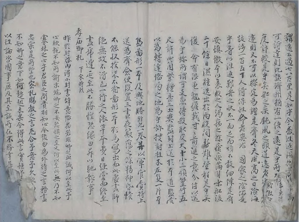
申光璞書 張漢相「蔚陵島事蹟」
(1)蔚陵島事蹟
表紙
(2)甲戌九月日、江原道三陟營将・張漢相、馳報內、蔚陵島被討事。
(訳注)
・甲戌年は、肅宗20年。1694年。すなわち元禄7年。
「竹島一件=鬱陵島争界」の始まった翌年である。安龍福の一回目の来日の翌年。肅宗実録によれば、張漢相の鬱陵島捜討は、9月19日(甲申)から10月6日(庚子)まで。この年の9月は29日までなので、あわせて17日間となる。鬱陵島滞在期間は、本文にある通り、9月20日から10月3日までの13日間。
・「被討」は「捜討」の誤記か。
肅宗実録(肅宗20年8月14日己酉条)
漢相、以九月甲申、乘舟而行、十月庚子、還至三陟。言倭人往來固有迹、而亦未嘗居之。地狹多大木、水宗【海中水激處, 猶陸之有嶺也】亦不平、 艱於往來。欲知土品、種麰麥而歸。 明年復往、可以驗之。
~出発から鬱陵島到着まで~
去九月十九日、巳時量(午前10時ごろ)、自三陟府南面荘五里津待風所、發船。
綠由曾已馳報、為有在果。
僉使、與別遣譯官・安慎微、領來諸役各人、及沙格并一百五十名、
騎船各一隻、汲水船四隻良中、從其大小分載。
同日巳時量(午前10時ごろ)、囬西風開洋。是如乎。
(訳注)
「有在果」は、原サイト掲載者は「僉使の名前」とするが、僉使は張漢相自身であろう。「譯官」は日本語通訳。このあとの鬱陵島捜討にも同行する。日本人と出会うことを予想しての鬱陵島行きである。
戍時(午後8時)、到大洋中。波濤險巇之勢、五里許二䖏。是乎。
所必是水宗、而諸波浪、所觸渙散、無適所向。是(3)如乎。
(訳注)
(2)-2-3字 「震」→「䖏」
同月二十日、子時(午前0時)、
漸入深洋、黑雲自北蔽天、而電光閃爍、影流澈波心。
狂風猝起、雨隨至、怒濤翻空、雲海相盪。
所秉船隻、若浮若沒、危險罔狀。
船中之人、莫不失措、舉皆惛倒之際、騎船柁木、又從而折破龙、無制船之策。
難以櫓木(4)直揷扵尾、及左右借以為力。是乎。
乃覆敗之患、迫在須●。是如乎。
風雨漸息、天又向曙、島在北方、水勢東走。
船中之人、因此甦醒、盡力櫓役、轉展向島。
巳時(午前10時)、艱到島之南。繁纜石角、暫時下陸。
炊飯之際、汲水船四隻、稍稍來到。而卜船■、能不知所向。是如乎。
酉時(夕方6時)、又自南洋而到、各船俱得免■
而南岸無船泊䖏、東南問涧口內、止宿。
(訳注)
・(4)-8-2 「無」抜け。 而南岸船泊䖏→而南岸無船泊䖏 南海岸には船着場なし。東南で止宿したのは、今の「道洞」か。
~島のあらまし。竹田。竹嶼。~
自二十(5)日、至十月初三日、留住之間、
恒雨少日、九月雪積、交下中峯腰上、雪積尸餘。是齊。
島之四方、秉船環審、則、懸岸撐空、層立壁岸。或有空缺、澗水成流、似是大旱不渴。
而、其間細流、幹溪不可殫記。是齊。
其周回、二日方窮、則、其聞道里、不過百五六十里乎。
■南濱海邊、有篁竹田、土䖏是遣。
東方五里許、有一小島、不甚高大。海長竹、叢生於一(6)面。
(訳注)
・有笪所田→有篁竹田
・海長竹叢生
竹嶼の説明。すでに「海長竹」が「叢生於一面」とある。1711年の「鬱陵島図形」の「所謂于山島」の記述と同じ。
~中峯に登る。「独島」を見る。~
霽雨■棬之日、入山、登中峯。則南北兩峯、岌崇相面、此所謂三峯也。
西望大関嶺、逶迤之狀。
東望海中、有一島。杳在辰方。而其大、未滿蔚島三分之一。不過三百餘里。
北至二十餘里、南近四十餘里、回互徃來。
西望遠近■度如斯。是齊。
西望大谷、中有、一人居基地、三所。又、有人居基地、二所。
東南長谷、亦有人居基地、七所。石葬十九所。
(訳注)ここまでは、中峯からの展望の説明と考えられる。「東望海中、有一島、杳在辰方。而其大、未滿蔚島三分之一、不過三百餘里」の「一島」は、竹島=独島のことと解釈されている。次の「北至二十餘里、南近四十餘里、回互徃來」は、島の大きさをあらわす文言か。
~船着き場の説明。日本人の器物を発見。~
(7)船泊䖏、則、東南間口、僅容四五隻之䖏。而、東南岸、則亦非可藏䖏。
是遣此䖏、有三釜三鼎、而二釜一鼎、則破傷軆樣、非我國之制也。
鼎則、無足無盖、可炊二斗米。
釜則、廣經尺許、深可二尺、容盛四五桶。
西方大谷、溪澗成川、沿邊開豁。此䖏為最而所泊䖏。
船隻可避東南風。而西風難避、無非在前泊船之所。
又有一鼎、可炊米斗、亦是彼物。(8)此邊岸上、有轆轤。亦非我國所造。
(訳注)
・「西方大谷」は今の「台霞」か?
・この「鼎」や「釜」や「轆轤」は、日本製のもの。大谷・村川の漁民たちが使用していたものと考えられる。
~島の自然地理学的説明 樹木・動物・水産物~
島中、崗巒重疊。而、山腰以上則皆是石角、以下則土山。
而勢絕險、洞壑深邃、樹木連抱。參天而蔽日者、不知其幾許。
積年空棄之地、人跡不到。
故、藤葛磐結、朽草木添阜排。擠錯絕卒、非人所可通逕。小小澗谷、不可窮探。
所謂樹木、盡是、冬栢、紫側栢、黃薜金木、嚴木、槐木、榆木、楮、椒、楓、桂樹、栢之類。而(9)其中、冬紫檀、最多。松木、直木、■木、橡等木、■終無一株。
而羽則鳥鷗、毛則貓兒而已。此外、別無飛走之屬。既無人居、又無木實可食。
而水族、則只有魰魚、而沿邊石堆䖏、或十、或百、成羣穴居、大如駒犢、小如犬豕。
間有生鰒、付諸岸磧者、軆小味薄。
(訳注)
・「魰魚」というのが、アシカのことか。
・「生鰒」=アワビと思われる記述もあるが、「軆小味薄」と評判は良くない。
~破船の板木~
四方浦邊、破船板木、片片飄着者、處處有之。而、或鉄釘、或木釘、或腐傷者、而審其稍木之制 (10)則彼我無別。已為裂破。
~東南崖岸の竹田~
而、東南崖岸、漂散最多竹田。東南麓三處、最多而每■可落皮牟、三十餘石。
且兩田、斫竹龙多。其傍斫置、數千竿、而或有陳枯者、或有未幹者。
自東南間、從谷中、向竹田十五里許、有小路處。此、必取竹者、徃來逕。
~島の概要~
大抵、環一島、皆名山。四面壁立、又斷缺䖏、則、兩崍成間、流水潺湲而已。
只一西方山麓、開成洞門、大川(11)流出、而沙礫堆積、不能成浦、船泊甚難。
中有峯巒、嵯峨洞壑、回互雖。無寬豁䖏、猶可開疊。
至於殘山平峽䖏、或有人居基地、石葬、而墓木連抱。
大㮣、島在三千里海洋之中、船隻不得、任意徃來。
則、雖有彼國橫占之舉、除防無策。欲設堡鉄、則人民無止接之策。
(訳注)
(11)-2-3 密→巒
(11)-3-7 科→平
所謂開垦䖏、樹木陰翳、藤葛成藪。九月積雪、寒氣倍冬。
夜半風殘之時、依然、如(12)兒啼女哭之聲、喧嘩碎長之聲、錚錚耳邊漸近。
船頭擬其魍魎海毒之舉、妖或慮率備犯之患。吹囉放砲、撀彀作聲、則瞬息不聞。
~ある怪奇のエピソード~
環島之時、至一處、日暮繋船、巖下炊飯。
次船、由沙磧、履磨中有遙之狀、與安慎微(訳官)同。
步行三里許、則自中峯逶迤一脈、山麓都是、層巖高壁、而遙開豁。
由此路望見、則連及山腰、疊石穴。與慎微相議曰、此(13)穴、不無害人、毒物移船、扵他䖏矣。
到三更後、天雨猝下、風浪大作、震雷電光、動山掀海、俄以兩止。
煙霞满島、遙聞巖穴中、眾人之聲、立扵船頭、號望見、則燈燭輝煌。
明日、食後、欲知其夜開異狀、更泊其處、
使軍官・朴忠貞、及砲手二十餘名探知、次入送巖穴。
(訳注)
(13)-6-13 八→入
則、久而不出、疑其陷坎、使人呼出。
則、忠貞先出、日「穴內三十餘步、豁然開敞、四層簷 (14)砌、
累石皆錬磨玉色、有文彩也。
十餘間尾家甚或極奢䴡、丹青、及戶舖之制、非泛然我國搆屋之規則、模樣大異。無他見物。而、近入簷下、則如硫黃・腐肉之嚊、滿鼻敝口、不能遠行、亦分明說道。」
是、去乙、僉使多率船卒六十餘名、親自入見、果如忠貞所告。
屋上藤葛、盤結之中階、砌庭城之內、蕭■無一累之塵、非人所居䖏。
則、強入非闋僉、不(15)喻心迷宜、不忍近入簷下。
~回船之日~
回船之日、自中峯霞氣、漸廣及扵海中。
大如東山、不知何物、浮沈數度、超出半空、向入山中。
風雨大作、非電震聲。而動如崩山之狀、此其他島有異者也。
(訳注)
(15)-3-11 八→入
~総括 竹田と樹木について~
所謂竹田、䖏䖏有之。而上項四千䖏■、小䖏二十餘石落只之地。大處三十餘石落只。
而皆可引水、作水田處。是齊。
樹木中、紫檀可作棺板。皆在扵山腰落巖(16)之間。
(訳注)
(15)-7-12 ?→作
(15)-7-13 (抜けている) 水田(一文字)
~総括 日本との関係~
古昔人民居基地、宛然未泯、則其為空。棄不過百餘年之前。
溪有洞口、若慮寇之策、則一夫當百夫之地。
彼船難欲、乆為結船、而風浪若開、則船必不保之勢。
(訳注)
(16)-1-10 完→宛
登島山峰、審望彼國之域、則、杳茫無眼杓之島。其遠近、未知幾許。而地形、似在於彼我間鼎釜。
取竹之路、彼人所為。緑由馳報狀。
壬寅春、外後裔、永陽、申光璞書。
(訳注)
この「壬寅」年は、いつか?
「外後裔」と書いているところからすれば、数世代の後か。
1722年 壬寅 景宗2 享保7 康熙61
1782年 壬寅 正祖6 天明2 乾隆47
1842年 壬寅 憲宗8 天保13 道光22
1902年 壬寅 光武6(高宗) 明治35 光緒28
1962年 壬寅 昭和37
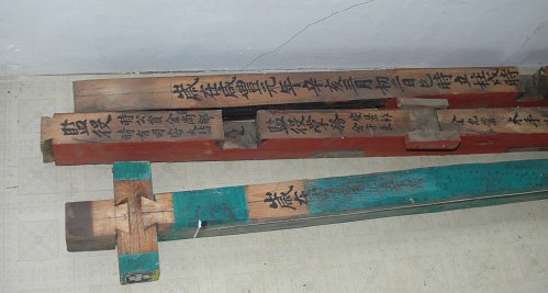
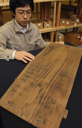
朴世堂『西溪雑録』(
p1 ), (
p2 ), (
p10 ), (
p11 )

 This nice map is showing Korea after the end of the World War II (1945) but before the Korean war. Caption is: "Geographia Map Company's Large Scale Map of Korea; Super-detailed map in the size of 41x27 inches, Attractively colored, A special map of Asia and Formosa included". It was produced under the direction of Alexander Gross, F.R.G.S. and copyright was owned by Geographia Map Co., Inc. (New York).


