竹島問題の歴史

7.12.13

"First discovery of Chinese documents marking Dokdo as Korean territory." Really?

According to a December 1 "Yonhap News" article HERE (a Korean article HERE), a researcher at the Korea Dokdo and Marine Territory Research Center, which is under the state-run Korea Maritime Institute, has published a book of Chinese diplomatic documents, which includes a 1947 document that says the following:
"Jukdo (竹島) is northeast of Ulleungdo; its area is small, but it is a neighboring island of Ulleungdo."  
죽도(竹島)는 울릉도의 동북부에 있는데 면적은 크지 않으나 울릉도의 속도가 된다.
Notice that the English article replaces "Jukdo" (竹島) with "Dokdo," a common, intentional mistranslation in Korea. The researcher is claiming that the "Jukdo" being talked about in the document is "Dokdo" (Liancourt Rocks), even though the sentence clearly says the island is northeast of Ulleungdo, not southeast, and is named "Jukdo" (竹島), not "Dokdo" (獨島).

Anyone familiar with Ulleungdo knows that there is a small island two kilometers off the northeast shore of Ulleungdo named "Jukdo" (竹島), which just happens to use the same Chinese characters for its name as the Japanese island of "Takeshima" (Dokdo), which is about 90 kilometers southeast of Ulleungdo, not northeast.

Here are some questions to consider when regarding the Korean researcher's claim:
  1. If there was an island named "Jukdo" (竹島) 2 kilometers off the northeast shore of Ulleungdo and an island whose name used the same two Chinese characters (竹島) 90 kilometers to the southeast of Ulleungdo, which one do you think the Chinese would have most likely referred to as "a neighboring island of Ulleungdo"?
  2. If the Korean name for the island 2 kilometers off Ulleungdo's northeast shore was "Jukdo" (竹島)" and the Korean name for the island 90 kilometers to the southeast of Ulleungdo was "Dokdo" (獨島), why would the Chinese use the name "Jukdo" (竹島), instead of "Dokdo" (獨島), if it were referring to the island 90 kilometers away?
  3. If the Chinese document were claiming the island 90 kilometers southeast of Ulleungdo was a neighboring island of Ulleungdo, why would the Chinese use the Japanese name "Takeshima" (竹島) to refer to the island instead of the Korean name "Dokdo" (獨島)? 
The 竹島 in the Chinese document was obviously referring to Ulleungdo's neighboring island of "Jukdo" (竹島), which is only 2 kilometers off Ulleungdo's northeast shore, not to Japan's "Takeshima (竹島), which is 90 kilometers to the southeast of Ulleungdo.

In his 1948 book entitled "General Knowledge of Joseon" (朝鮮常識)," famed Korean historian Choi Nam-seon (崔南善)  wrote that Korea's easternmost (極東) island was Ulleungdo's "Jukdo" (鬱陵島竹島) and gave its longitude as "130º 56 min 23 sec East" (東経130度56分23秒). Therefore, if one of Korea's most famous historians was saying that "Jukdo" (竹島), not "Dokdo" (獨島), was Korea's easternmost island in 1948, why would the Chinese have said anything differently in 1947?
 
This is a perfect example of how some Koreans are grasping for straws as they try to prove Korea's claim to Liancourt Rocks (Takeshima / Dokdo). Unfortunately for Korea, instead of finding a document that supports Korea's claim to Liancourt Rocks, the Korean researcher seems to have found yet another document that supports the Japanese claim since the document suggests that even the Chinese had never heard of Ulleungdo having a neighboring island named "Dokdo" (獨島).


Americans on Liancourt Rocks in 1945?

Today I chatted with an man who claimed his father was a US marine who spent "several months" on Liancourt Rocks in 1945 as part of an advance marine gunnery unit. He said they were given a large barrel of water and some cases of SPAM and essentially abandoned there for several months.

Has anyone ever heard about Americans being stationed on Liancourt Rocks?

2.11.13

Disposition of the Korean Scholar

A Korean made a rebuttal statement to my this post according to published studies by Korean scholar. We must validate Korean studies.

1. A study by Prof. Shin Yonha and Choi Chang-geun

A Korean newspaper article about a Japanese book published by the Mainichi newspaper
"A named endowed chair professor of the Hanyang University, Shin Yong-ha and chief researcher of the Seoul Graduate School of International Studies, Choi Chang-geun, showed[....]Moreover, on page 82 of the book, “The Treaty of Peace with Japan” that contains the “Japanese territorial map,” there is a detailed Dokdo map with the explanation that “Japanese administrative power was suspended by order number 677 of the General Headquarters of the Allied Powers.” However, there is no content that Dokdo is a Japanese territory in the book."
table of contents
page82
This is the table of contents and page82  of the book.
Takeshima(page 82) mentioned in the part of Japanese territory. It seems that Prof. Shin disguised passed over the table of contents. The text body explains that Takeshima belongs to the Japanese local county at that time.
" Though Takeshima is in the Goka town of Ochi county NOW, Japanese government’s administrative right for it was ceased by SCAP’s directive in 1946."
It seems that Prof. Shin disguised passed over this sentence. Prof. Shin fabricates is often hallucinate too. He explained 48 countries agreed to "Agreement Respecting the Disposition of Former Japanese Territories".

2. A study by Prof. Hosaka

Prof. Hosaka managed “Truth of Dokdo” video series. He explained the Japanese book published by the Mainichi newspaper too.
Truth of Dokdo
"
The Japanese government pronounced the results of San Francisco Peace Treaty with Japan in 1951(6th Sept, 1951) in the Mainichi Newspaper. The Mainichi Newspaper, in corporation with the Japanese Ministry of Foreign Affairs, produced a Map of Japan describing Dokdo to be Korean territory."
There is no evidence that Japanese government corporated with Mainichi newspaper. It seems that Prof. Hosaka was hallucinate too. This is a publication about the SF peace treaty super edited by the Japanese Ministry of Foreign Affairs at Sep 1951.
" Though Takeshima was excluded from Japanese administration area by SCAP’s directive in 1946, it follows that Takeshima is recognaized as Japanese territory. Because the treaty never mention about it"
Japanese Ministory of Foreign Affairs recognaized that Takeshima is Japanese territory.

Prof. Hosaka also negated the Rusk note in the video series according to the Dulles's statement.
John Foster Dulles served as the U.S. special envoy to the Peace Treaty with Japan, and latter became U.S. Secretary of State. He acknowledged in an address that the “Letter by Rusk” represented only the view of U.S.“ The US View re Takeshima is simply that one of many signatories to the treaty.”(from a document recorded by U.S. Secretary of John Foster Dulles) 
Although the Japanese Ministry of Foreign Affairs published the content of the “Letter by Rusk” in ten languages, the letter represented merely the views of the U.S. at that time, not the agreed upon consensus of the Allies Powers.
The original secret document about the Dulles's statemant is here. Dulles pointed another important thing. Prof. Hosaka disguised passed over it.
"US view regarding Takeshima simply that of one of many signatories to treaty. Article 22 was framed for purpose settling treaty disputes. "
USA and other signatories must go to International Court of Justice, when she has a problem in the interpretation of the treaty. There are no signatory countries who go to ICJ about the Takeshima. All signatory countries has been silent, though he Rusk note opened in 1968. International law view the silence as the connivance.
S.F peace treaty
Article 22
If in the opinion of any Party to the present Treaty there has arisen a dispute concerning the interpretation or execution of the Treaty, which is not settled by reference to a special claims tribunal or by other agreed means, the dispute shall, at the request of any party thereto, be referred for decision to the International Court of Justice.
Prof. Hosaka said follows too.
Truth of Dokdo
"A letter from U.S. Ambassador in Korea who unaware of the Letter by Rusk, indicated that he operated on the assumption that Dokdo was Korean territory. (Nov, 1952)
The original source of the letter is here. The letter didn’t say that U.S. Ambassador in Korea thought Dokdo was Korean territory. It seems that Prof. Hosaka must fabricate be hallucinate. Here is another letter by the U.S. Ambassador in Korea at Oct, 1952.
 “Although this Embassy is not in possession of complete information regarding the Department’s views on the ownership of Tokto Island (also called Dokdo, Takeshima, or the Liancourt Rocks), it appears that its status is unsettled."
U.S. Ambassador in Korea didn’t thought that Dokdo was Korean territory. It seems that Prof. Hosaka disguised passed over this letter. Prof. Hosaka also claimed as follows.
Munhwa News
“ USA had assumed the role of the drafter about the peace treaty. It was set rule that the draft made by USA discussed at the Far Eastern Commission and the article of the draft was decided according to the agreement by commission members (11 countries). However the Rusk note wasn’t discussed at the Far Eastern Commission and commission members didn’t agree. USA sent Rusk note to Korea government behind closed doors and didn’t open other countries. USA beguiled into believing that the commission members agreed the Rusk note and sent only to Korea. Because USA violated this draft decision rule, Rusk note was invalid”
 Prof. Hosaka doesn’t show the evidence about this draft decision rule. Though I researched documents about the Far Eastern Commission, but I can’t find any document about the rule. The probability that the rule which Prof. Hosaka asserts was fabricated does not exist is very high, because the Far Eastern didn’t have the function about the peace treaty. Commission members can't discuss about the territory at the commission, because the commission didn’t have the right about the territorial adjustments.
FAR EASTERN COMMISSION AND ALLIED COUNCIL FOR JAPAN
II. Functions
A. The functions of the Far Eastern Commission shall be:
1. To formulate the policies, principles, and standards in conformity with which the fulfillment by Japan of its obligations under the Terms of Surrender may be accomplished.
2. To review, on the request of any member, any directive issued by the Supreme Commander for the Allied Powers or any action taken by the Supreme Commander involving policy decisions within the jurisdiction of the Commission.
3. To consider such other matters as may be assigned to it by agreement among the participating Governments reached in accordance with the voting procedure provided for in Article V-2 hereunder.
B. The Commission shall not make recommendations with regard to the conduct of military operations nor with regard to territorial adjustments.
C. The Commission in its activities will proceed from the fact that there has been formed an Allied Council for Japan and will respect existing control machinery in Japan, including the chain of command from the United States Government to the Supreme Commander and the Supreme Commander's command of occupation forces.
I think that Prof. Hosaka should change the title of his video to “Truth of childish Korean propaganda technique”.


3. Disposition of the Korean Scholar about Takeshima.

  • They pass over the sentence of sources which are inconvenient for Korea.
  • They give priority to sources by private person and company than government. They
    give priority to sources under the discussion process than result. They give priority to internal document than official diplomatic document. (It thought that their criteria of the priority is whether  it is convenient for Korea or not.)
  • They  make their own rule for denial inconvenient truth without proof.
  • They often are hallucinate.
Then we should verify original sources which Korean scholar cited.

1.11.13

2013 Oct 31 - The Government of Japan released English version of Takeshima Video


Finally, Japanese Ministry of Foreign Affairs renewed HP and uploaded English version of Takeshima video.
Korean government instantly protested.

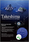
The Issue of Takeshima


゛Takeshima - Seeking a Solution based on Law and Dialogue”


MOFA of Japan also released a leaflet on Takeshima. You can download from below.

Leaflet: Japan's Position on Takeshima
"Japan's position on Takeshima"

29.10.13

1768 - The first "Map of Japan" which plotted Takeshima was confirmed - ”The New Divisional Map of Whole Japan(改製日本扶桑分里図)"(1768)


The Shimane Prefectural Government has confirmed "The New Divisional Map of Whole Japan(改製日本扶桑分里図)"(1768), which is the original drawing of  "Newly-carved Highway Map of Japan(改正 日本輿地路程全図)"(1779) that serve as the basis of Japan’s claim to Takeshima islets in the Sea of Japan.


It shows "Matsushima", today's Takeshima, northwest of the Oki islands.  "The New Divisional Map of Whole Japan" is Nagakubo Sekisui's hand-written map and two islands, Takeshima(Ulleungdo) and Matushima(Takeshima) are re-rewritten from north-northwest to the right location with the phrase "“Viewing Koryo is just the same as viewing Inshu (=Oki island) from Unshu (=Izumo) (見高麗猶雲州望隠州)”" which are cited form "Inshu Shicho Gohki". The both islands were clearly depicted as Japanese territorial islands.

First and Second editions of Nagakubo's Kaisei Nihon Yochi Rotei Zenzu left Takeshima and Matsushima uncoloured along with other several islands including Okinoshima, Kuchinoerabushima, Ezo and Hachijojima, likely because they are remote islands.

Nagakubo made the map based on SEKI, Sokoh's "Description on People and Couties ( 新人国記)" (1701) and Mori Kohan's "The Field Chart of Japan, The Atlas of Japan (日本輿地図 日本分野図)"(1754,) both of which showed Takeshima(Ulleungdo) as Japan's. He shifted the direction of two islands apparently based on the phrases from Inshu Shicho Ghoki.

As has already pointed out, Nagakubo had later published historical geography book on China "Map of Asia and Small Orient(亜細亜小東洋圖)"(1835)  and it clearly shows Takeshima/Dokdo as Japanese territory.  He had compiled the fruits of years of study on geography, astronomy and history  into the book. There is no doubt Nagakubo considered both islands as Japanese territory.


Shimane Prefecture also confirmed a rough drafts of "Map of Japan" from the 18th century. (right)

They are the first "whole Japanese map" which plotted Takeshima.


“According to the prefecture, the discoveries include a map draft titled “Kaisei Nihon Fuso Bunrizu” made in 1768 and a rougher draft titled “Nihonzu.”

The maps show islands called Matsushima, the name of Takeshima at the time, northwest of the Oki island chain in what is now part of Shimane Prefecture.

The maps were made by Nagakubo Sekisui, a geographer from Mito in today’s Ibaraki Prefecture. The maps preceded another map called “Kaisei Nihon Yochirotei Zenzu” that was made by Sekisui upon permission from the feudal government of the time that is cited by the current government as the grounds for Japan’s claim to Takeshima.

Nagakubo’s descendants gave the rough drafts to the Takahagi board of education in Ibaraki Prefecture. (Japan Times)”


〈Reference〉
Shimane Prefecture News Release (Japanese)

Korea’s Dokdo video uses unauthorized clips from Japanese public broadcast(NHK)


Though Korea has claimed the deletion of Japanese Takeshima video to Japan, Korea removed her video.
The Foreign Ministry came under fire Sunday for unauthorized use of clips from Japanese broadcaster NHK in its promotional video on the Dokdo islets.
The ministry removed the 12-minute video last Friday from its website and YouTube as the public broadcaster complained that the film uses without permission some 10-second scenes from its 2011 drama depicting the Russo-Japanese war.
Original article is here.

6.10.13

Korean Deception about the treaty interpretation


I The principle of the interpretation of a geographical term

1) The geographical term must be interpreted as the natural geographical meaning

Eastern Greenland CASE (P.C.I.J. 1933) 
The natural meaning of the term is its geographical meaning as shown in the maps. If it is argued on behalf of Norway that these treaties use the term "Greenland" in some special sense, it is for her to establish it, and it is not decisive in this respect that the northern part of Greenland was still unknown. She has not succeeded in showing that in these treaties the word "Greenland" means only the colonized area.
Vienna Convention on the Law of Treaties, 1969 
Article 31. General rule of interpretation
1. A treaty shall be interpreted in good faith in accordance with the ordinary meaning to be given to the terms of the treaty in their context and in the light of its object and purpose.

2) The renunciation area by Japan on the peace treaty

"Japan recognizing the independence of Korea, renounces all right, title and claim to Korea, including the islands of Quelpart, Port Hamilton and Dagelet."
 This is the text about the renunciation area by Japan on the peace treaty on September 8, 1951(SF treaty) and the draft of the treaty on July 3, 1951. (After June,1951, this text was not revised)

A. The natural geographical meaning by USA geographer (original source)
 Prof. Boggs recognized that the text doesn’t contain Liancourt Rocks.

If it is decided to give them to Korea, it would be necessary only to add "and Liancourt Rocks" the end of Art. 2, par. (a).

B. The natural geographical meaning by Korea (Korean first interpretation)

 Korean government required addition of "Dokdo(Liancourt Rocks)" in the text to USA on July 19, 1951.(original source)
My Government requests that the word "renounces" in Paragraph a, Article Number 2, should be replaced by "confirms that it renounced on August 9,1945, all right, title and claim to Korea and the islands which were part of Korea prior to its annexation by Japan, including the island Quelpart, Port Hamilton, Dagelet, Dokdo and Parangdo."
 Korea recognized that Dagelet (Ulleungdo) and Dokdo(Liancourt Rocks) as another island and the text doesn’t contain Liancourt Rocks.

C. The strained geographical meaning by Korea (Korean Second interpretation)

 After the SF treaty was issued, Korea government changed her interpretation about the text. She sent a verbal note to Japan on 10 February 1954 and said follows.
Dokdo(Liancourt Rocks) was approved as a Korean territory as an islet belonging to the Ulleungdo(Dagelet) by Chapter 1 Article 2 (a) of the treaty.
 This second interpretation is contradictory to her first interpretation.  Because USA denied Korean first interpretation and request (see rusk note, No184 document), Korea had to change her interpretation for keeping her political greed.  USA didn’t open these diplomatic negotiations with Korea till 1969. Then Korea could tell a lie and keep her second strained interpretation. But now, USA had opened the diplomatic negotiations and the Korean deceit had became clear.

II Unity theory of the international law

 The Korean second interpretation is based on the unity theory. To be sure, the international law may accept the attached island as same legally unit of maim island.
PALMAS CASE, Hague, 1928
As regards groups of islands, it is possible that a group may under certain circumstances be regarded as in law a unit, and that the fate of the principal part may involve the rest.

1) Application of unity theory in precedents

  For the application of the unity theory to the uninhabited island, the important criterion of the court is whether distance is less than 12 nautical mile. Because present the area of the territorial water is 12 nautical mile from coast, the court can't be disregarded.
LAND, ISLAND AND MARITIME FRONTIER DISPUTE , ICJ, 1992
The Mohabbakah Islands are four rocky islets which amount to little more than navigational hazards. They are Sayal Islet, which is no more than 6 nautical miles from the nearest point on the Eritrean mainland coast, Harbi Islet and Flat Islet; all three of these are within twelve nautical miles of the mainland coast. Finally, there is High Islet, which is less than one nautical mile outside the twelve-mile limit from the mainland coast, and about five nautical miles from the nearest Haycock island, namely South West Haycock. 

2) Application to Liancourt Rocks

 The distance from Dagelet (Ulleungdo) to Liancourt Rocks is about 50 nautical mile. Then it will not apply the unity theory to Liancourt Rocks.
LIGITAN AND PULAU SIPADAN , ICJ, 2002 
The Court, however, considers that this cannot apply to Ligitan and Sipadan, which are situated more than 40 nautical miles away from the three islands in question.
<supplement>
Dokdo(独島) is Korean name of the Liancourt Rocks. The meaning of Dokdo is isolated island. Korean name is contradictory to Korean unity theory.

III Conclusion

1) The natural meaning of the Chapter 1 Article 2 (a) of the SF treaty

 The Chapter 1 Article 2 (a) which defined the renounced area by Japan doesn't contain the Liancourt Rocks. This is also proved by the first Korean interpretation.

2) Korean deceptive interpretation

 The drafter of the treaty (USA) have notified the truth meaning of the Chapter 1 Article 2 (a) of the SF treaty. But Korea have disregarded the truth meaning and fabricated the second interpretation intentionally for her political greed. This Korean fraudulent practice breaks ”estoppel” and "good faith" for the interruption.

3) Unity theory

 Liancourt Rocks is not an attached island of the Dagelet (Ulleungdo).

28.9.13

2013年9月30日(月) 26:35~27:30 「届かぬ声~60年の歳月がもたらしたもの」~山陰中央テレビ (FNSドキュメンタリー大賞)

山陰中央テレビ制作「届かぬ声」(FNSドキュメンタリー大賞)が下記の通り、9月30日(月) 深夜に首都圏で放映されます。是非ご覧になって下さい。また、他の掲示板等でも宣伝して下さい。よろしくお願いいたします。

2013年9月30日(月) 山陰中央テレビジョン放送【TSK】
26:35~27:30 届かぬ声~60年の歳月がもたらしたもの~
http://www.fujitv.co.jp/b_hp/fnsaward/backnumber/22.html


第22回FNSドキュメンタリー大賞ノミネート作品『届かぬ声 ~60年の歳月がもたらしたもの~』(制作:山陰中央テレビ)

島根県隠岐の島町から北西約157キロに位置する竹島。江戸時代から戦前にかけ多くの日本人が島へ渡り漁をしてきた。しかし、突如として韓国に不法占拠されて約60年。日本人は竹島に近づくことさえできない。その竹島が大きな注目を浴びたのは去年8月。当時の韓国大統領・李明博が竹島に上陸したことだった。国際司法裁判所への単独提訴など問題解決に向けた動きも出たが、その後具体的な進展はなくなった。
こうした中、竹島の地元・隠岐ではあきらめにも似た言葉がこぼれ始めている。日韓外交のはざまで揺れ続けながら、いくら竹島の返還を求める声をあげても、届くことのない叫び。問題が解決されないまま60年の歳月を経た今、これまで続けてきたTSKの取材をもとにこの「竹島問題」をあらためて考える。
<9月30日(月)26時35分~27時30分>
--------------------------------------------------------------------------------
 
 
竹島問題に取り組む八幡昭三さん竹島問題に取り組む八幡昭三さん

 
 島根県隠岐の島町から北西約157キロに位置する竹島。江戸時代から戦前にかけ多くの日本人が島へ渡り漁をしてきた。しかし、突如として韓国に不法占拠されて約60年。日本人は竹島に近づくことさえできない。
  2005年3月に島根県が「竹島の日」条例を制定したことがきっかけに、この問題が大きくクローズアップされて以来、TSKは島根県の放送局として竹島問題の取材を積極的に続けている。そして、韓国による不法占拠が続く竹島が、あらためて大きく注目をされたのは去年8月。当時の韓国大統領・李明博が竹島に上陸したことだった。当時の政府は問題解決のため国際司法裁判所への単独提訴を提案したが、結局提訴は行われないまま。一方で、政権交代後の今年2月、島根県主催の「竹島の日」記念式典に初めて政府関係者が出席し、公式な立場で領有権を主張するなど問題解決に向けて前進したかと思えば、「外交的配慮」からかその後具体的な動きはなく、今では以前のような停滞感も漂っている。
 
竹島の絵本の読み聞かせをする杉原由美子さん竹島の絵本の読み聞かせをする杉原由美子さん
 
 こうした中、竹島の地元・隠岐ではあきらめにも似た言葉がこぼれ始めている。隠岐の島町久見地区の住民で、竹島問題に長年取り組んでいる八幡昭三さんと竹島問題を幅広い世代に伝えるために絵本を製作した杉原由美子さんだ。彼らの先祖は竹島へ渡り漁をしており、過去どのような経緯で先祖が竹島を開拓し、豊かな漁場として利用してきたを後世に伝えようとしている。こうした活動を通じて竹島問題の解決へ声を上げ続けているが、その声が政府へ届くことは未だない。
  この問題が解決されないまま過ぎた60年の歳月がどのような状況を生み出しているのか、そして今後地元の人たちの叫びが国へ届くことはあるのか。
  これまで続けてきたTSKの取材をもとに、この「竹島問題」をあらためて考える。

ディレクター・平井謙太(山陰中央テレビ報道部)コメント

「私は島根県出身ですが、学校教育で竹島について学ぶ機会はなく、竹島問題については深く知りませんでした。しかし竹島問題を取材するにつれて、この問題を取り巻く日韓の温度差、そして国民全体の認知度、理解度不足を感じるようになりました。さらに一刻も早い問題の解決を望む竹島の地元、隠岐の島町久見地区の住民たちの切実な声を直接聞くことで、この問題を広く伝えなければいけないのではないかと考えるようになりました。竹島という難しいテーマですが、約1時間に集約された隠岐の人たちの竹島に対する思いが多くの人に伝わり、この問題について考えてもらうきっかけになれば良いと思います」
 
--------------------------------------------------------------------------------
 
<番組概要>
 
◆番組タイトル
第22回FNSドキュメンタリー大賞ノミネート作品
 『届かぬ声 ~60年の歳月がもたらしたもの~』
 (制作:山陰中央テレビ)
◆放送日時
9月30日(月)26時35分~27時30分

◆スタッフ
統括 小原千明
プロデューサー 山根収
ディレクター 平井謙太
ナレーション 槇大輔
取材・撮影 山陰中央テレビ報道部
編集 野田貴
音効 金子寛史
MA 小嶋雄介
 
http://www.fujitv.co.jp/b_hp/fnsaward/22th/13-370.html

23.5.13

Agreement Respecting the Disposition of Former Japanese Territories Part II


I.Documents concerned with “Agreement Respecting the Disposition of Former Japanese Territories”

1) U.S. Draft dated November 2, 1949(original source is here)

The Bureau of Far Eastern Affairs of US Dos assumed that Japan cedes a part of her territory to China and Soviet directly.
Article 4
1. Japan hereby cedes to China in full sovereignty the island of Taiwan (Fomasa) and ……….
Article 5
1. Japan hereby cedes to the Union of Soviet Socialist Republics in full sovereignty the portion of the island of Sakhalin (Karafuto) …….
Article 6
1. Japan hereby renounces in favor of Korea all rights and titles to the Korean mainland territory……..

2) Sebald’s proposal about the method of the disposition, November 19, 1949(original source is here)

Sebald recommended a subsidiary document which define disposition than the direct cession by the treaty.
Article 4 through 12. We suggest that in the treaty Article 4 through 12 of the November 2 draft be omitted, and that in a document subsidiary to the treaty among the signatories other than Japan the disposition of the treaties formerly under Japanese jurisdiction be agreed upon. The necessity of direct cession would thereby be removed from the treaty proper and Japan would not rest under the necessity of being a party to it.

3) Boggs's proposal about the territorial clauses on Dec 8 , 1949 (original source is here)

Boggs drafted territorial clauses according to the Sebald's suggestion and sent to the Bureau of Far Eastern Affairs.
Article 4
Japan hereby [cedes and] renounces all territory <, all territorial claims ???????> and all mandate, and concession rights, titles and claims outside the territorial area described in Article 3, and accepts the disposition of these territories that has been made or that may be made by the parties concerned, or by the United Nations in accordance with the trusteeship provisions of Articles 77, 79, and 85 of the Charter of the United Nations.

4) Territorial Clauses & Agreement Respecting the Disposition of Former Japanese Territories, Dec 15, 1949(original source is here)


The Bureau of Far Eastern Affairs modified the Boggs's territorial clauses and drafted the "Agreement Respecting the Disposition of Former Japanese Territories". The draft of the agreement was incomplete with many mistakes. "Territorial Clauses" and "Agreement Respecting the Disposition of Former Japanese Territories" contradicts in the point of Takeshima. The Bureau of Far Eastern Affairs sent those documents to the Legal Adviser of Dos on Dec 15, 1949.

Territorial Clauses of Peace Treaty
Article4
1. Japan hereby renounces on behalf of itself and its nationals all territorial and mandate rights, titles and claims outside the territorial area described in Article 3.
2. The Allied and Associated Powers retain their rights in respect to disposition of the territories referred to in the preceding paragraph which were under Japanese sovereignty, pending conclusion of an agreement or agreements among them providing for disposition of such territories.
Agreement Respecting the Disposition of Former Japanese Territories
Article3
The Allied and Associated Powers agree that there shall be transferred in full sovereignty to the Republic of Korea all rights and titles to the Korean Mainland territory and all offshore Korean islands, including Quelpart (Saishu To), the Nan how group (San To, or Komun Do) which forms port Hamilton (Tonaikai), Dagelet Island (Utsuryo To, or Matsu Shima), Liancourt Rocks (Takeshima),.... 

5) The Legal Adviser responded to the Bureau of Far Eastern Affairs on Dec 19, 1949(original source is here)

 The Legal Adviser was negative for making a two ducument plan. This is last record about the draft of the agreement. Dos did not correct even mistakes of the draft.
Since territorial dispositions are generally matters of considerable importance to the various nations concerned, most nations would doubtless desire that the disposing document be of the same dignity, namely, a treaty. Hence, two documents would need to be ratified. Where the intended recipient is agreed upon, and no important matters call for outside action, it would be a matter of some difficulty to explain to other nations the necessity for the departure from practice, unless a substantial reason appeared. It is our understanding that the reason advanced for separate documents in the case of cession of Japanese territory is that the absence of “cession to” clauses in the Treaty of Peace will be of psychological benefit to Japan.

6) U.S. Draft dated December 29, 1949(original source is here)

The Bureau of EA gave up two documents plan and rolled back to the direct cession plan.
Article 5
2. Japan hereby cedes to the Union of Soviet Socialist Republics in full sovereignty the portion of the Kurile islands.
Article 6
1. Japan hereby renounces in favor of Korea all rights and titles to the Korean mainland territory……..

7) S.F. treaty on September 8, 1951

Finally, Allies gave up direct cession and Japan simply renounced her territory by the treaty.
(a) Japan recognizing the independence of Korea, renounces all right, title and claim to Korea, including the islands of Quelpart, Port Hamilton and Dagelet.
(b) Japan renounces all right, title and claim to Formosa and the Pescadores.
(c) Japan renounces all right, title and claim to the Kurile Islands, and to that portion of Sakhalin and the islands adjacent to it over which Japan acquired sovereignty as a consequence of the Treaty of Portsmouth of September 5, 1905.

However Allies did not determine the disposition of the renounced territory. Then the disposition became indefinite.

PRINCIPLES OF PUBLIC INTERNATIONAL LAW, Ian Brownlie
Sovereignty may also be indeterminate so far as the process of secession may not be seen to be complete at any precise point in time. [...] For example, in a peace treaty Japan renounced all right to Fomasa. However, Fomasa has not been the subject of any act of disposition; it has not been transferred to any state.

II. Analysys of “Agreement Respecting the Disposition of Former Japanese Territories”

1)FACT

  • This draft of the agreement is the primitive draft which has many mistakes and blanks.  US Dos swiftly abandoned this draft after receiving the Legal adviser's suggestion.
  • This draft of the agreement is internal document of the US Dos. Allies didn't know this draft of the agreement, because US Dos didn't distribute to Allies. Allies neither  signed or ratify at this document, too.
  • This draft of the agreement is contradictory to the San Francisco treaty about Takeshima. The Allies don't have authority to dispose a territory without an agreement of Japan. Because Japan didn't renounce Takeshima at the SF treaty, Allies don't have the power of disposition about Takeshima. 

2)The difference from the Rusk note

  • Rusk note was made based on the treaty draft dated June 14. The sentence of the Article2 of this draft is same as the S.F. treaty. Then Rusk note is adjusted with S.F. treaty. But this draft of the agreement contradicts the S.F. treaty
  • While Rusk note was a formal bilateral diplomatic document issued by drafter of the Treaty and sent to ROK government, this draft in concern was just an internal primitive document which has no trace of distribution to any other countries outside.

Which is more important between the San Francisco treaty with signatures by Allies and Japan, and this draft of the agreement without signatures?  Of course, priority is given to the S.F. treaty. Supplementary means of interpretation of the treaty can't use in order to deny the treaty.

3) Korean interpretation

Dokdo Research and Preservation Association & Dokdo Institute
"Agreement Respecting the Disposition of Former Japanese Territories"(1950) drafted in preparation for the San Francisco Treaty in 1951 stated Dokdo as a"Korean territory' in substantive enactment. Therefor although Dokdo was not mentioned in San Francisco Peace Treaty, Dokdo was recognized as a Korean territory in "Agreement Respecting the Disposition of Former Japanese Territories" and "SCAPIN No. 677".
 "Agreement Respecting the Disposition of Former Japanese Territories" is internal primitive draft. Because Japan and Allies didn't agree, this draft of the agreement is legally invalid. Moreover the their interpretation about SF treaty violates the "Principle of Completeness of Boundary Treaties" of the international law.

Advisory Opinion of the Permanent Court on the Interpretation of Article 3, Paragraph 2, of the Treaty of Lausanne (1925)
It is . . . natural that any article designed to fix a frontier should, if possible, be so interpreted that the result of the application of its provisions in their entirety should be the establishment of a precise, complete and definitive frontier.


Special thanks to Matsu and Kaneganese

29.4.13

Agreement Respecting the Disposition of Former Japanese Territories(連合国の旧日本領土処理に関する合意書)

連合国の旧日本領土処理に関する合意書は、竹島の主権を韓国に移転するとしたものである(全文はこちらをクリック)。韓国では、この合意書(以下、「合意書草案」という)について「条約草案」や「連合国の合意の証拠」とする解釈がなされているようである。しかし、このような解釈は時系列的に矛盾するとともに、竹島を放棄領土に含めなかったサンフランシスコ条約の内容とも整合しない。

1.合意書草案の位置づけ

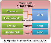
 まず、合意書草案直前の1949年11月2日の平和条約草案の領土規定について整理してみる。当条約草案では日本の領土範囲を規定した条項と共に日本が処分する領土が規定されており、処分方式は地域ごとに「割譲」と「権利・権原の放棄」の2種類に分かれている。(右図参照)
  • 台湾等:中国に割譲する。(Cedes to China)
  • 南樺太・クリル諸島等:ソ連に割譲する。(Cedes to the Union of soviet Socialist Republics)
  • 朝鮮半島等、小笠原諸島、琉球諸島:全ての権利と権原を放棄する。(renounces all right and title)
  この草案に対して1949年11月17日にシーボルドが意見書の詳細を国務省に提出した。シーボルドの意見として、「1.竹島を日本領とすること、2.日本への精神的な圧迫を緩和するため日本を囲いこむような規定をやめること」の2つが知られているが、領土の処分方法に関する提案も行っている。
1949年11月19日 11月9日の条約草案に関する詳細な意見
修正された3条に続いて、「3条で記述された領域外において、日本は割譲又は全ての権利、権限、権原及び請求権を放棄する」で始まる条項を挿入することを提案する。
(11月2日の草案において、新たな主権者への直接的な割譲に依拠しない日本による放棄の方法が8条から12条に認められることに留意する)
我々は、11月2日の条約草案にある第4条から12条を削除し、日本の管轄下にあった従前の日本領土の処分に関する補足的な文書に日本を除く連合国間で合意することを提案する。このことにより、条約本体での直接的な割譲の必要性をなくすとともに、日本がそのために拘束され続ける必要がなくなる。
補足文書における台湾の扱いについて、カイロ宣言後に発生した中国の不安定な状況が、島の機械的な処分をも不可能にしていることを根拠に、国連信託統治の賛否を決める住民投票を考慮するよう提案する。(11月2日の草案に脚注の議論は、中国が平和条約に調印しない場合を想定したものであるが、台湾の処分の決定における重要な政治的かつ戦略的要因の処理としては不適切と思われる)
シーボルドは右図のように、「1.平和条約での日本の放棄」「2.補足文書で連合国が放棄領土に対する処分を決定」と2段階による処分方法を提案した。このような提案を行った理由として、連合国内の東西陣営間の対立による平和条約締結の遅延を恐れたためと考えられる。合意書草案の前文は、以下のとおりとなっておりシーボルドの処分方法の提案に従って作成されたものであることがわかる。
 連合国の旧日本領土処分に関する合意書
1950年に日本と締結した平和条約に関連する連合国及び関連する国家は、条約により日本が放棄した領土について、以下のとおり処分する。

2.合意書草案の作成年月日とベースとなった条約草案

 合意書草案を発見したシン・ヨンハは1950年以降に作成されたものとしていたが、chaamieyさんのサイトによると李碩祐の研究では19491219日の作成とし、「韓国の独島領有権が再び認められたもの」と解釈しているようである(李碩祐の論文を見ていないので日付を特定した根拠は不明)。前述のとおり合意書草案は条約の放棄領土に対する処分を決定するものであり、条約における放棄領土と整合してなくてはならない。合意書草案にある「豆満江の河口から約三海里にある国境の終点・・・( the seaward terminus of the boundary approximately three nautical miles from the mouth of the Tumen River)」との表現は、1947年11月2日と1949年12月29日の条約草案にしかなく、この何れかの条約草案をベースに補足文書として合意書草案が作成された。また、合意書草案にある「連合国が竹島の主権を韓国に移転する」ためには、日本が平和条約で竹島の処分権を連合国に移転済みでなければならない。条約草案の変化を時系列に整理すると以下のとおりとなる。
  • 194911 2日条約草案:竹島が放棄領土に含まれる
  • 19491229日条約草案:竹島が放棄領土から除外
この内、合意書と整合するのは11年2月の条約草案であり、12月29日の条約草案とは論理矛盾をきたす。よって、この合意書が作成されたのは、シーボルドの詳細意見書の1949年11月16日~竹島を放棄領土から除外した条約草案の1949年12月29日までの間となり、李碩祐の比定した1949年12月19日である可能性が高い。

3.合意書草案への連合国の合意 

 独島学会ではこの条約草案に48カ国の同意があったように解釈しているように見受けられるが、連合国が合意した事実は確認されていない。合意は国を代表する者による署名等によってなされなければならない(ウィーン条約法条約第11条〜16条)。しかしながら、この合意書草案に対して、署名等の行為がなされた事実は存在しない。合意がないことは、この合意書草案の末尾にある合意の日付及び合意場所の記入欄が空白のままであることからもわかる。
Done at the city of ------------in the English language,this -------day of------,1950.
 また、朝鮮半島の処分が書かれた第3条にも「・・・」と省略があり、この合意書が草案としても成熟したものでないことがわかる。
Dagelet Island (Utsuryo To, or Matsu Shima), Liancourt Rocks (Takeshima), and all other islands and islets to which Japan had acquired title lying outside and to the east of the meridian 124゜15´E. longitude,


 更に、アメリカが他の連合国に平和条約に関する意見照会を行ったのは、1950年9月11日の条約草案を要約した「覚書」が最初であり、それ以前に作成された条約草案等について他の連合国に配布・周知された事実は確認できない。「合意」があったとするのであれば、どの国が、いつ、どこで、どのような手段で合意したのかを示すのが学者として最低限の責務である。

4.合意書草案後の領土処分方法の推移

 竹島を日本領とした1949年12月29日条約草案であるが、領土処分方法については台湾や南樺太等は従来どおりの中国等への割譲による処分方法となっている。しかしながら、1950年9月11日に作成された条約草案において「日本は、英国、ソビエト、中国、米国によってなされる将来的(to the future)な合意を承認する」と割譲方式がなくなると共に合意将来に先送りた。11月24日の 対日講話7原則では、「条約発効後1年以内に決定されない場合には,国際連合総会が決定」と、連合国内で合意ができなかった時の対処が追加された更に、条文が「全ての権利・権限を放棄する」と修正され、連合国の合意の存在自体が削除され条約成案となった。例えば「朝鮮の主権を韓国に移転する」とする処分に東側諸国が同意するわけもなく、現実問題として日本が放棄した後の領土処分については何ら決定することはできなかったのである結果的にサンフランシスコ条約では、シーボルド意見書における1ステップ目(日本による領土放棄)のみが実行され、連合国による放棄領土の処分は行われかった。
 なお、連合国内の紛争のためサンフランシスコ条約で放棄領土の処分を明確にできなかったことは、ダレスも講和会議の演説で述べている。

5.サンフランシスコ条約の領土処分に関する国際法学者の解釈

 国際法学者のブラウンリーは、サンフランシスコ条約の領土処分について「連合国に処分権を与えた」とし、例えば台湾について連合国が処分権を行使しなかったため主権が未確定とした。また、その後の連合国の黙認・承認によって台湾の主権が凝固されうるとしている。このブラウンリーの解釈は、シーボルドの提案した「放棄→処分」の2段階による処分の内、2段階目の処分がなされなかった事実とも合致している。

6.韓国側の解釈の問題点

  恐らくラスク書簡を否定するためであろうが、事実に依拠しない拡大解釈を行っている。この合意書草案に連合国が合意したとするのであれば、署名等によって連合国が合意した事実を証明することが必要である。しかし、そのような事実を存在しない。また、最終的に連合国および日本が合意したサンフランシスコ条約成案では、放棄領土から竹島は除外されている。ラスク書簡が重要なのは、サンフランシスコ条約成案と同じ文面(韓国に配布された1951年3月草案以降、朝鮮の放棄領土に関する文案は修正されていない) に対する条約起草者の意見だからである。時間を遡及し条約成案を否定する合意書草案と異なり、ラスク書簡は条約成案と整合しているのである。

<修正履歴>
 ・Matsuさんの指摘を受け合意書3条の「・・・」に関する記述及び「豆満江の河口から約三海里云々」の追加(2013/05/07)

9.4.13

1887 - "New Geography" by Okamura Masutaro doesn't mark Takeshima as Korean territory


This "New Geography" in 1887 by Okamura Masutaro (岡村増太郎『新撰地誌』明治20) (from Waseda University’s site) is a revised edition of 1886’s. 

On August 2012, Korean media reported that “Pre-colonial Japanese textbooks mark Dokdo as Korean territory”. However, it’s an another typical false claim by Korean historian. 


As you can see, the island they claim “Dokdo” on the map is not Takeshima/Liancourt Rocks but Ulleungdo/Dagelet from its geographic coordinates. And strictly speaking, it is not for sure that this two islands are marked as Korean territory or not. It’s absurd to jump to the conclusion that other country considered them as “Korean” if they are not marked as Japanese territory. (The spot between Oki and Dagelet/Ulleugdo seems to be just an ink blot. )

 (Right : GIF animation by O.M.R GT)


Although almost all the maps after 1882 made by the Hydrographic Department of the Japanese Imperial Navy and the General Staff of Office of Japanese Imperial Army blotted out Argonaut, it still remained on many private mapmaker’s maps including textbook or supplementary reader makers, such as Mr. Okamura, wrongfully map Argonaut and Dagelet thoroughout Meiji era. It seems that Ministry of Education were not keen on this issue. In some cases, especially among San-in residents, people’s old recollection of Takeshima/Ulleungdo-Matsushima/Liancourt Rocks combination in Edo era brought slight confusion on the description of those islands in private publication. 

However, again, it is not wise to automatically conclude that Japan’s Matsushima was today’s Takeshima/Liancourt Rocks during Meiji or Japan considered Matsushima(=Ulleungdo in Meiji in fact) as Korean. It’s required to be very careful to ascertain what the “Matsushima” or two islands near Korea represent from its geographical coordinates, description of history and whole context of the book, and so on. 

What we need is academic/scientific analization. No more propaganda, please.