The following video shows some close-ups of Liancourt Rocks and also the small cave where a small amount of fresh, but not really drinkable water accumulates. It also mentions that a lot of seagulls on "Dokdo" are killed by falling rocks.
The following portion of the video complains about a lack of support from the Korean government to do "Dokdo" research. In Japan, on the other hand, the video shows a special "Takeshima" section in the Shimane Prefecture Library, and a Korean professor talking about seeing a group of Japanese researchers pouring over declassified documents at the U.S. Library of Congress, which he said gave him an uneasy feeling. does not provide many materials or support for Dokdo research. while the Japanese government, on the other hand, not provide support for Dokdo research whiltalks about the Shimane Prefecture Library, which has a whole section dealing with the Takeshima (Dokdo) issue. Also, at the end of the video, during an interview with one of the Japanese researchers who often supports Korean claims, the Japanese researcher suggests that Koreans are not asking his permission to translate his books.
The following portion of the video talks about the 1998 Japan/Korea fishing agreement, which many Koreans are unhappy with because they feel like they conceded something to Japan in regard to Dokdo (Takeshima).
Showing posts with label Videos - Korean. Show all posts
Showing posts with label Videos - Korean. Show all posts


7.9.08
2008 Aug - New Dokdo Propaganda Video
Notice how the video shows maps of Ulleungdo with its neighboring island of Usando (于山島), which is shown as one island, and then claims that it is Dokdo (Liancourt Rocks)? The video also intentionally misinterprets the Japanese documents and maps.
Do I really need to ask why the video did not show any of the Ulleungdo maps that clearly show Usando (于山島 - 우산도) was Ulleungdo's neighboring island of Jukdo (竹島 - 죽도), which is only about 2.2 kilometers off Ulleungdo's east shore?
Do I really need to ask why the video did not show any of the Ulleungdo maps that clearly show Usando (于山島 - 우산도) was Ulleungdo's neighboring island of Jukdo (竹島 - 죽도), which is only about 2.2 kilometers off Ulleungdo's east shore?
19.8.08
"Dokdo is Korean Territory"?
Korean Dokdo propaganda videos are pretty much all the same. When it comes time to prove Korean claims, they just flash through a bunch of old Korean and Japanese maps and documents with little or no explanation, but with plenty of background music. The reason they do that is that they do not want people to look too closely at the evidence because then people might start asking such questions as, "Why do the old Japanese maps show Liancourt Rocks (Dokdo), but Korean maps do not?"
The Korean videos are designed to play on Korean emotions while relying on people's ignorance of the facts. That is why we see many Korean commenters here claim that Korea has a lot of evidence to support her claim on Dokdo, but then those same people are unable to explain what that evidence is.
Anyway, enjoy the video. At least, the music is nice.
The Korean videos are designed to play on Korean emotions while relying on people's ignorance of the facts. That is why we see many Korean commenters here claim that Korea has a lot of evidence to support her claim on Dokdo, but then those same people are unable to explain what that evidence is.
Anyway, enjoy the video. At least, the music is nice.
22.6.08
1950's Korean Video: "Dokdo & the Peace Line"
Below is a Korean video from the 1950s entitled, "Dokdo & the Peace Line." The video has no audio, and seems to be a collage of different film clips. One of the clips seems to show "Dokdo," and another shows what might be a captured Japanese fisherman, who seems to be badly burned and wounded.
20.6.08
1939 Jpn textbook shows Liancourt Rocks as Korean?
Below is a video from an MBC News broadcast that claims that a professor emeritus at Korea's Gyeongsang National University in Jinju has a 1939 Japanese-government textbook showing Liancourt Rocks as Korean territory. The professor says that because the rocks are outlined in the same color as the Korean peninsula, this textbook should end the argument about whose territory "Dokdo" is. The news announcer also claims that it is more evidence that Japanese claims on Liancourt Rocks are fabrication.
Let's ignore, for a moment, the fact that Japanese documents clearly prove that Liancourt Rocks were incorporated into Japanese territory in 1905, which means that even if the Liancourt Rocks on this 1939 primary school textbook map were shown to be Korean territory, it would have been an obvious error. Also, let's ignore the fact that the map clearly shows the rocks labeled with the Japanese name of Takeshima (竹島), instead of Dokdo (獨島). Instead, let's focus on how MBC NEWS seems to have enhanced the map to try to prove the Korean claim.
The following is a screenshot of the MBC News video at 29 seconds into the video. Notice how the Korean peninsula, Ulleungdo, and Liancourt Rocks (Takeshima - 竹島) are outlined in heavy bluish purple, but Tsushima (對馬島) and the Japanese mainland do not really seem to be outlined.
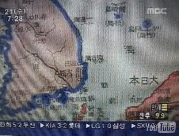
Now look at a sreenshot at 31 seconds into the video. Notice how the Japanese mainland and Tsushima have suddenly been outlined in bright orange? MBC News obviously added the orange outline to Japan.

Now, look at the following screenshop at 1:29 into the video. Notice that the Korean mainland, Ulleungdo, and Liancourt Rocks are no longer outlined in heavy bluish purple? It seems that MBC News forgot to add the outline to this photo of the map. This is more evidence that MBC News enhanced the video.
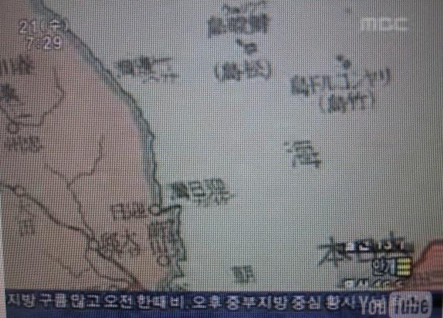
Finally, the following is a closeup of the map from another source. Notice how Ulleungdo (鬱陵島) and Liancourt Rocks (Takeshima - 竹島) do seem to have a tinge of blue on one fringe, but was that intentional or was it just bleeding from the blue lines used to indicate the water? For example, notice that there also appears to be some bleeding of blue around some of the Chinese characters on the map.

I am not sure if the map meant to show Liancourt Rocks as Korean territory or not, but if it did mean to show the rocks as Korean territory, then it was clearly an error since documents clearly prove that Japan incorporated Liancourt Rocks in 1905 and changed their name to Takeshima (竹島).
I think it was pretty silly for the Korean professor to suggest that this map should end the Dokdo-Takeshima debate. I also think it was deceitful of MBC News to alter the map to try to make their argument.
Let's ignore, for a moment, the fact that Japanese documents clearly prove that Liancourt Rocks were incorporated into Japanese territory in 1905, which means that even if the Liancourt Rocks on this 1939 primary school textbook map were shown to be Korean territory, it would have been an obvious error. Also, let's ignore the fact that the map clearly shows the rocks labeled with the Japanese name of Takeshima (竹島), instead of Dokdo (獨島). Instead, let's focus on how MBC NEWS seems to have enhanced the map to try to prove the Korean claim.
The following is a screenshot of the MBC News video at 29 seconds into the video. Notice how the Korean peninsula, Ulleungdo, and Liancourt Rocks (Takeshima - 竹島) are outlined in heavy bluish purple, but Tsushima (對馬島) and the Japanese mainland do not really seem to be outlined.
Now look at a sreenshot at 31 seconds into the video. Notice how the Japanese mainland and Tsushima have suddenly been outlined in bright orange? MBC News obviously added the orange outline to Japan.
Now, look at the following screenshop at 1:29 into the video. Notice that the Korean mainland, Ulleungdo, and Liancourt Rocks are no longer outlined in heavy bluish purple? It seems that MBC News forgot to add the outline to this photo of the map. This is more evidence that MBC News enhanced the video.
Finally, the following is a closeup of the map from another source. Notice how Ulleungdo (鬱陵島) and Liancourt Rocks (Takeshima - 竹島) do seem to have a tinge of blue on one fringe, but was that intentional or was it just bleeding from the blue lines used to indicate the water? For example, notice that there also appears to be some bleeding of blue around some of the Chinese characters on the map.
I am not sure if the map meant to show Liancourt Rocks as Korean territory or not, but if it did mean to show the rocks as Korean territory, then it was clearly an error since documents clearly prove that Japan incorporated Liancourt Rocks in 1905 and changed their name to Takeshima (竹島).
I think it was pretty silly for the Korean professor to suggest that this map should end the Dokdo-Takeshima debate. I also think it was deceitful of MBC News to alter the map to try to make their argument.
Subscribe to:
Posts (Atom)