The Actœon hove to for a few hours off Dagelet Island, which emerges in solitary grandeur from the floor (2,000 feet deep) of the Japanese Sea, and rises to 4,000 feet above it. It lies 100 miles distant from the mainland of Korea, is clothed with forest from the verge of perpendicular cliffs of 500 feet, and is 20 miles in circumference. On every side were herds of seals, filling the air with sorrowful sounding cries, perhaps from terror at our appearing. We could make no headway through the dense undergrowth. La Perouse discovered this island in 1786, but there is no record of his landing.A few half-starved Korean fishermen were collecting seaslugs, etc., for Chinese epicureans, but had only a ramshackle old junk in which to make the passage across a stormy sea in almost perpetual fog. A weird and lonely spot is Dagelet Island.
29.8.11
1902 - "On the Coasts of Cathay and Cipango Forty Years Ago"
In an 1902 book entitled On the Coasts of Cathy and Cipango Forty Years Ago, Englishman William Blakeney recounts his experiences traveling in the Far East between 1857 and 1862 on the British ship Actœon. On page 191, he describes his ship's visit to "Dagelet Island" (Ulleungdo) in June 1859 as follows:
1897 - "The Century Dictionary and Cyclopedia," Vol. X
The 1897 edition of "The Century Dictionary and Cyclopedia," which was published in New York, listed "Hornet Island" (Liancourt Rocks) as Japanese territory on page 237.

28.8.11
1905 - May - Aug.: "The Outlook," Vol. LXXX (Page 818)
"The Outlook" was a weekly newspaper published in New York, but, apparently, four months of articles were also compiled into a book, from which the article below is found.
In a July 29, 1905 article entitled "The Destruction of the Baltic Fleet" (pp. 811 - 819), the author George Kennon mentioned Liancourt Rocks (p. 818) in his description of the Japanese victory over the Russian fleet. When he mentioned Liancourt Rocks, he put in parentheses "Takeshima," which shows that, in July 1905, Americans already knew about Japan's incorporation of "Takeshima."
In a July 29, 1905 article entitled "The Destruction of the Baltic Fleet" (pp. 811 - 819), the author George Kennon mentioned Liancourt Rocks (p. 818) in his description of the Japanese victory over the Russian fleet. When he mentioned Liancourt Rocks, he put in parentheses "Takeshima," which shows that, in July 1905, Americans already knew about Japan's incorporation of "Takeshima."
1909 - "Asiatic Pilot" - Description of Ulleungdo and Liancourt Rocks
Below is a description of "Matsu Shima" (Ulleungdo) and "Hornet islands (Liancourt Rocks) from the 1909 edition of "Asiatic Pilot: East cost of Siberia, Sakhalin Island and Korea" (Page 189).
One thing I found interesting about the article was this: "A rock or islet lies off Seal Point, the southern extreme of the island." This interests me because a "rock or islet" appeared at that position on some old maps of Ulleungdo, but there no longer appears to be anything there today. I wonder if it was destroyed or removed for some reason.
One thing I found interesting about the article was this: "A rock or islet lies off Seal Point, the southern extreme of the island." This interests me because a "rock or islet" appeared at that position on some old maps of Ulleungdo, but there no longer appears to be anything there today. I wonder if it was destroyed or removed for some reason.
ISLANDS IN THE JAPAN SEAMatsu Shima (Dagelet Island) is a collection of sharp conical hills, clothed with wood, crowned by an imposing peak, 4,000 feet high, in the center, in Lat. 37° 30' N., Long. 130° 53' E. The island is 18 miles in circumference and semicircular in shape.
There are several rocks or islets along the coasts of Matsu Shima, principally, however, on the northern and eastern sides, some reaching an elevation of 400 to 500 feet. A rock, with a depth of 2 to 3 feet, lies on the northeastern side of Matsu Shima, with Boussole rock, near its eastern extreme, bearing 200° about 2 3/4 miles. With the exception of this rock, they are all, like the island, steep-to, and the lead affords no warning; but none of them are more than 1/4 mile from the cliffs, except Boussole rock, the largest, which is 1,400 yards from the northeast coast. Hole rock, on the northern shore, is remarkable from having a natural archway through it, while nearly abreast it on the shore is a smooth but steep sugar-loaf hill, apparently of bare granite, about 800 feet high. A rock or islet lies off Seal Point, the southern extreme of the island.
The sides of the island are so steep in most places that soundings from a boat could only be obtained, almost at the base of the cliffs. Landing may be effected in fine weather on the small shingly beaches which occur at intervals, but the greater part of the island is inaccessible. Anchorage is charted southward of Boussole rock.
During the spring and summer months some Koreans reside on the island; their principal occupation is to collect and dry large quantities of shellfish.
Hornet islands (Liancourt rocks) are described as being two barren rocky islets, covered with guano, which makes them appear white; they are about a mile in extent northwest and southeast, \ mile apart, and apparently joined together by a reef. The western islet, elevated about 410 feet above the sea, has a sugar-loaf form; the easternmost is much lower and flat topped. The water appeared deep close-to, but these rocks are sometimes dangerous at night from their position, being near the track of vessels steering up the sea of Japan for Hakodate.Position—According to a survey made in 1908 by the Japanese Government, the eastern islet is situated in Lat. 37° 14' 18" N., Long. 131° 52' 22" E.
1906 Aug - "Korea Review," Vol. 6 -- "Ul-leung Do"
Below is an interesting August 1906 article from the Korea Review entitled "Ulleungdo." What I found especially interesting about the article was the following description of Ulleungdo:
The main island is about eighteen miles long from east to west and perhaps twelve miles wide. There are several little rocky islets near it.Notice that it gave the dimensions of Ulleungdo and said that it had "several little rocky islets near it." The Korean for "rocky islets" is seokdo (石島 - 석도). Nothing was said about Dokdo (Liancourt Rocks), which is ninety kilometers southeast of Ulleungdo.
THE KOREA REVIEW
AUGUST, 1906.UI-Ieung Do.(DAGELET ISLAND.)For the Korean, the far-away, isolated island group in the Japan Sea is well named Ul-leung, which may be freely translated "Lonely Forest Expanse." On the mariners'chnrts it is called Dagelet Island, doubtless after some early explorer in this region. To the Japanese it is known as Matsushima or Isle of Pines. It lies 400 li (120 miles) off the eastern coast of Korea, almost due east from the town of Sam-ch'uk which is the point of embarkation for the infrequent craft which ply to the island. With a good west wind Korean boats reach the island in two days. It is this distance which lends enchantment and which has worked so powerfully upon the imagination of the people. In their estimation the island of Quelpart is comparatively near. No one was ever banished to Ul-leung. It would be too cruel a fate. It would be exile, not mere banishment in the Korean sense.Anciently the Chinese named this island Mu-reung, "Military Hill," after the name of a certain celebrated spot in China, but later they concluded that this name was too honorable for the distant and uninhabited island; so they changed it to U-reung or "Wing Hill." There is poetry in the name, for the main island is not unlike in shape to a wing spread out upon the sea.Isolated as this spot is it is not unrenowned in history. The Sam-guk-sa, the most ancient of Korean histories, states that under the name of U-san a Kingdom or tribe existed on the island in the days of ancient Silla. How it became known to Silla that the island was inhabited we are not told but we know that, in 513 A. D. during the reign of the Silla King Chi-jeung, the great general Yi Sa-bu, "Chief of A-Silla"* devised a way of conquering the semi-savages of this U-san without the shedding of blood. He fashioned a number of wooden lions and placed them in the prows of his war boats. As he neared the coast of the island and the startled natives saw these lions gaping with red mouths and glittering eyes, and heard the threat of the general that if they did not surrender at discretion he would let loose the horrid beasts upon them, they fell on their knees at once and did obeisance to Silla. At this time the name Ul-leung Do was conferred.
The main island is about eighteen miles long from east to west and perhaps twelve miles wide. There are several little rocky islets near it.In the year 1160 Kim Yu-rip the governor of Kangwun Province was so adventurous as to make a trip to this island. His report is interesting and shows that he was a fairly keen observer. He said in his report to the King at Songdo that he had climbed to the crest of the central mountain peak and found it 13,000 paces from the west coast and from the summit to the east coast was 10,000 paces. From the summit to the south and north coasts was 15,000 and 8,000 paces respectively. This would make the island 23,000 paces long and the same in width. Reckoning even three feet to a pace, which is excessive, we should have about fourteen miles. We imagine he measured it with his eyes rather than his feet, but in any case his estimate was fairly accurate.He reported that he found seven places where villages had formerly existed. He also found a bell, a pagoda, stone images and trees that had been planted by man. But at that time the island was without inhabitants.FOOTNOTE: *It is surmised by some that the "a" of this A Silla meant "great." It is probable that the word Silla is of purely native origin and not of Chinese derivation. The "A" is probably identical with the Japanese O meaning great.
He said furthermore that he had seen in histories that in the thirteenth year of King Wang-gbn's reign, 931 A. D., tribute had been sent to Songdo in the shape of toraji, a species of campanula, used for food and medicine and also beans. His opinion was that the land was very fertile and he stated that the pine forests were magnificent. He could make no definite estimate of the number of people who were living there at the beginning of the dynasty, 918 A. D., but he found slab's of stone {probably slate) with which the houses were roofed.At the time of the founding of the present dynasty, 1392 A. D., this island had become a place of refuge for criminals. In 1400 a government detective of Sam-ch'uk, named Kim In-u, went to the island and persuaded some of the refugees to come back to the mainland and submit to the authorities. He reported that bamboo, the size of a pine tree, flourished on the island and that the rats there were as large as cats.* Not fearing contradiction he affirmed that the peach stones there are as large as a man's two fists!In the days of King Se jong, the palmy days of the present dynasty, 1437 A. D., a man named Nam was appointed to have charge of the island. At that time some seventy refugees, all of the Kim family or clan, were living there.In 1470 a man named Pak Chong-wun visited the island and was detained there several months because of the weather. He found no inhabitants but brought back to the King an offering of bamboo of enormous size and some oysters to match.From early in the present dynasty the government sent a military officer to the islaud once in three years. He took fifteen axes and brought back samples of wood and other vegetable products.Japanese connection with the island began at least twenty years ago. They had
FOOTNOTE: *This through mistranslation probably gave rise to the storv that the shores of Ul-leung are infested with huge rats and the forests with 'wild cats ami that the two have periodical pitched battles.
discovered the splendid pine timber and began to help themselves. Koreans in greater or smaller numbers have occupied it for the better part of a century. In 1886 it was the writer's fortune to meet a man named Mitchell who had obtained some sort of concession to cut timber on Ul-leung and was on his way to Seoul in connection with the business. Complaints were frequent lietween the years 1880 and 1895 that Japanese were denuding the island of its fine growth of pine. Representations were made, we believe, by the Korean government and an attempt was made to put an end to this thieving but with poor success.
In 1898 the government began to take a more lively interest in that outlying domain and put the island in charge of an officer called a Kam and later, in 1900 placed a prefect there and named the place Mu-ta-dong or "District of the Fog Star," not inappropriately, since the prevailing rains are all from the east. The island was carefully measured and found to be sixty li (eighteen miles) from east to west and and forty li (twelve miles) from north to south.The products of the island as reported today are bamboo, pine timber, peaches, a wood called sung-nam (石楠), rattan, cedar, reeds, a sea animal "like a cow with red eyes but no horns," [probably the sea lion]. This animal is called kaji by the Koreans and they say it will attack and kill single men but will retreat to the water before a number of men. It is said the mountain ginseng abounds there but no one dares to bring it to the mainland, because if the attempt is made the boat will surely be wrecked. In verification of this the Koreans relate the story of a Japanese who defied the augury and took a basket of the valuable roots on board a boat in a basket. The trip was a stormy one and at last the waves became so high that the impious man threw the Jonah overboard; whereupon the sea calmed at once!At the present time there is a Korean population of 3,500 living in 600 or 700 houses. There are some Japanese police there to keep order between Koreans and Japanese, though up to a recent time, there were almost no Japanese resident on the island.
Little as the Koreans know about Ul-leung they prize its possession very highly and consider it an important part of the empire. The most valuable product is the pine lumber, which is so large that the finest and largest coffins can be made of it withont showing a single knot in the wood! Ul-leung pine is always requisitioned for royal burial caskets
18.8.11
The Diplomat: "Why Dokdo Matters to Korea"
The Diplomat, which describes itself as "the premier international current-affairs magazine for the Asia-Pacific region," has posted an online article entitled "Why Dokdo Matters to Korea." I did not like some of the things said in the article, so I wrote the below comment.
One of the claims in the article is that the Japanese lawmakers who were denied entry to Korea a couple of weeks ago were "attempting to visit the disputed islands of Dokdo/Takeshima." Another is that "Japan’s annexation of the islands [Dokdo/Takeshima] was among the first in a series of actions that led to the colonization of the peninsula."
Here is how I responded to the article, though it includes a few corrections to mistakes I found in my comment after it was posted:
There are many problems with this article.
First, the Japanese lawmarkers did not go to Korea to visit “Dokdo” (Takeshima). They went there to visit the Dokdo Museum on the Korean island of Ulleungdo, which is about ninety kilometers northwest of “Dokdo.” The museum houses maps and documents that Koreans say support their claim to “Dokdo.” The Japanese stated that they had no intention of visiting the disputed islets.
Second, Korea refuses to take the dispute to the International Court of Justice (ICJ) not because Koreans have some “powerful historical memory” of Japanese colonial rule, but because Korea has no maps or documents to support any historical claim to “Dokdo.” In other words, Korea knows the ICJ would rule against her.
The reason Korea has no maps or documents is that her claims were all fabricated shortly after World War II with the hope that she would be able to gain Japanese territory, which included not only “Dokdo” but also the Japanese island of Tsushima. The United States, however, rejected Korea’s claims. In an August 9, 1951 letter to the Korean ambassador, US Secretary of State Dean Rusk wrote the following.
“As regards the island of Dokdo, otherwise known as Takeshima or Liancourt Rocks, this normally uninhabited rock formation was according to our information never treated as part of Korea and, since about 1905, has been under the jurisdiciton of the Oki Islands Branch of Shimane Prefecture of Japan. The island does not appear ever before to have been claimed by Korea….”Korea never even attempted to provide the US with evidence to support her claim. Instead, Korean President Syngman Rhee simply declared “Dokdo” Korean territory after the 1951 Treaty of Peace with Japan, which allowed Japan to keep the island.
After visiting the Far East in 1954, US Special Mission Ambassador James Van Fleet wrote the following in his post-mission report:
"The Island of Dokto (otherwise called Liancourt and Take Shima) is in the Sea of Japan approximately midway between Korea and Honshu (131.80E, 36.20N). This Island is, in fact, only a group of barren, uninhabited rocks. When the Treaty of Peace with Japan was being drafted, the Republic of Korea asserted its claims to Dokto but the United States concluded that they remained under Japanese sovereignty and the Island was not included among the Islands that Japan released from its ownership under the Peace Treaty. The Republic of Korea has been confidentially informed of the United States position regarding the islands but our position has not been made public. Though the United States considers that the islands are Japanese territory, we have declined to interfere in the dispute. Our position has been that the dispute might properly be referred to the International Court of Justice and this suggestion has been informally conveyed to the Republic of Korea."While Korea has no old maps showing “Dokdo,” by any name, or any documents showing that Koreans ever visited the islets before the Japanese started taking them there as deckhands on Japanese fishing boats in the early 1900s, Japan has maps of the islets dating back to the 1600s and documents clearly describing them. Also, Japan officially incorporated “Takeshima” (Dokdo) into Shimane Prefecture in February 1905, after receiving a 1904 request to do so by a Japanese fisherman who was using the islets to capture and process sea lions.
The incorporation of Takeshima had nothing to do with the colonization of Korea. The islets were just a small group of rocks that had little or no strategic value and were not a part of Korea, so it is wrong for the writers of the article to write that “Japan’s annexation of the islands was among the first in a series of actions that led to the colonization of the peninsula.”
Korean “outrage” over Japanese claims to “Dokdo” is the result of about sixty years of fabricated Korean propaganda. It is not Japan who refuses to discuss the issues in the dispute; it is Korea. To solve the problem, Korean historians need to start telling the truth about the history of “Dokdo.”
15.8.11
1955 - “Introduction to Dokdo Issue (獨島問題概論)” - ROK Government Blotted out Rusk Note to hide the truth from its own Diplomats.
In 1955, ROK Minisitry of Foreign Affairs published the book titled “Introduction to Dokdo Issue (独島問題概論)”. The purpose of this book is, according to the preface written by KIm Dong-Jo(金東祚), a Minister of Foreign Affairs of ROK, to help Korean diplomats’ at overseas agencies of the Ministry of Foreign Affairs aquire better understandings on Dokdo Issue. However, the “American Embassy’s Note Verbale No.187” which dates on 4th Dec. 1952 attached in the 6th of “ANNEX” section of the book had crucial flaw for better understanding of the Issue.
Note that it ends with “etc”. If you see other documents in the Annex, they add “etc” for the section they omitted mainly because it has not direct relationship with the Issue of Dokdo/Takeshima. However, As was shown in the previous post, original American official Note No.187 dated on 4th Dec. 1952 had contained the part of notification of Rusk Note following the bombing matter and it clearly denied ROK claim on Dokdo and warned her that U.S. considered Takeshima/Dokdo is Japanese territory. ROK government apparently blotted out to conceal the fact that their claim on Dokdo had been already rejected by U.S. , leaving the islets to Japan, from its own diplomats. Check the original document below.
As has told in the previous post, ROK government used the fact that U.S.’s suspension of the bombing on Liancourt Rocks after Korean fishermen/women were almost killed on 15th September, 1952. The document was thus included in the book for the purpose to reinforce their logic. However, Takeshima was finally decided to be released from bombing range by the U.S. & Japan Joint Committee on 19 Mar., 1953, not Korea-U.S. Committee, because of the petition by Shimane Prefecture.
Although Rusk Note went to public on April 1978, even today, Korean government keeps telling lies, such as Usando is Dokdo’s old name, to its own people and never stops illegal occupation on Japanese islets. The only way for innocent Korean people to escape from deception by its own government is to see the first-hand historical documents and old maps which are available on this blog.
The original idea of this “discovery” was brought by yabutarou and the photocopies of the book was provided by matsu. It was discussed on this blog on January 2010.
Related posts and links;
1946 - Jan 29 - SCAPIN 677
1946 - Feb 13 - "Conference with GHQ/SCAP concerning separation of the administration"
1946 - Jun 22 - SCAPIN 1033
1947 - Sep 16 -SCAPIN 1778
1949 - Nov 14 - Willam J. Sebald's telegram
1949 - U.S. Maps DOES NOT Confirm Korean Sovereignty Over Dokdo
1949 - Nov 14 - A letter from W. Walton Butterworth
1949 - Dec 29 - U.S. Draft made on December 29, 1949
1950 - July - Commentary on Draft Treaty by the Department of State
1950 - Aug 7 - U.S. Draft made on August 7, 1950
1950 - Oct 26 - USA Answers to Questions Submitted by the Australian Government
1951 - Apr - May: Joint UK and USA Draft - extra(1)
1951 - Jun 1 - New Zealand's view - extra(2)
1951 - Jul 6 - SCAPIN 2160 (cache)
1951 - Jul 9 - Coversation of Yu Chan Yang with John F. Dulles
1951 - Jul 19 - The 2nd Conversation between Yu Chan Yang and John F. Dulles
1951 - Jul 26 - the Japan-U.S. Joint Committee designated Takeshima as a bombing range for the U.S. Forces stationed in Japan. (official gazette of Japan)
1951 - Aug 2 - Another letter from You Chan Yang
1951 - Aug 3 - Bogg’s Memorandum (On re-ceiving Boggs's memo. I asked the Korean desk to find out whether anyone in the Korean Embassy officer had told him they believed Dokdo was near Ullengdo, or Takeshima Rock, and suspected that Parangdo was too.)
1951 - Aug 9 - Rusk's Letter ( As regards the island of Dokdo, otherwise known as Takeshima or Liancourt Rocks, this normally uninhabited rock formation was according to our information never treated as part of Korea and, since about 1905, has been under the jurisdiction of the Oki Islands Branch Office of Shimane Prefecture of Japan. The island does not appear ever before to have been claimed by Korea. )
1951 - Sep 9 - San Francisco Peace Treaty
1951 - Sep 21 - Korean Government comprehended Takeshima/Dokdo was affirmed as a Japanese Territory in Peace Treaty
1952- Jan 18 - Syngman Rhee Line
1950's - Japan & Korea Argue Their Claims in 1950s Letters
1952 - Jul 26 - The Japan-U.S. Joint Committee designated Takeshima as a bombing range for the U.S. Forces (The Ministry of Foreign Affairs published this fact in the official gazette.)
1952 - Nov 5 - Confidential Security Information of USA ("It appears that the Department has taken the position that these rocks belong to Japan and has so informed the Korean Ambassador in Washington." )
1952 - Dec 4 - Confidential Security Information of USA ( "I much appreciate your letter of November 14 in regard to the status of the Dokdo Island (Liancourt Rocks). The information you gave us had never been previously available to the Embassy. We had never heard of Deen Rusk’s letter to the Korean Ambassador in which the Department took a definite stand on this question.")
1952 - Dec 4 - “American Embassy’s Note Verbale No.187” - U.S. iterates Rusk Note to ROK.
(American Embassy in Busan gave South Korean Government an official notification that Takeshima is not Korean territory by reminding Dean Rusk’s Note on 9th August, 1951, which rejected Korea’s demand for Takeshima/Dokdo. )
1953 - Mar 19 - Japan U.S. Joint Committee decided to release Takeshima from the designation of a bombing range for the U.S. Forcese
1953 Jul 22 - Confidential Security Information of USA “Possible Methods of Resolving Liancourt Rocks Dispute between Japan and ROK”( The United States Government's understanding of the territorial status of this island was stated in assistant Secretary dated August 10,1951.")
1953 - Nov 30 - Secret Security Information of USA ("The Liancourt Rocks case appears to have aspects in common with that of Shikotan Island" "Remind the ROK of our previous statement of view (the Rusk letter)")
1953 - Dec 9 - SECRET SECURITY INFORMATION by Dulles
1953 - Jul 22 - US Doc. Reconfirms Dean Rusk Letter (Letter from Office of Northeast Asian Affairs To E. Allan Lightner American Embassy, Pusan Korea by L. Burmaster Office of U.S. Northeast Asian Affair )
1953 - Oct 13 - Daiichi-Daihou Maru Incident - the dispute over the Rhee Syngman Line
1954 - Aug - Report of Van Fleet mission to the Far East, 26 April - 7 August , 1954
2008 - Jul 30 - Press Briefing by Senior Director for Asian Affairs at the National Security Council, Dennis Wilder, on President's Trip to Asia (cache)
“Introduction to Dokdo Issue (獨島問題概論)”(1955)
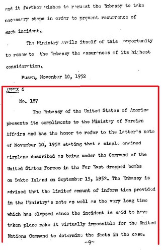
ANNEX 6
No. 187
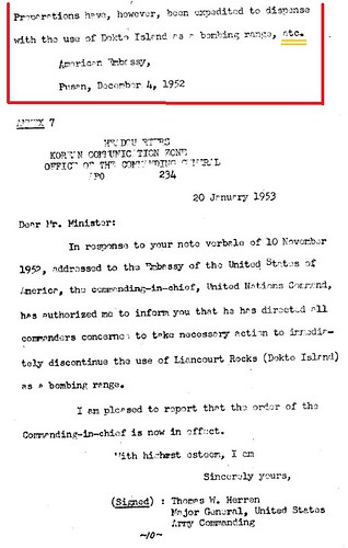
The Embassy of the United States of America presents its compliments to the Ministry of Foreign Affairs and has the honor to refer to the latter’s note of November 10,1952 stating that a single engine airplane described as being under the Command of the United States Forces in the Far East dropped bombs on Dokto Island on September 15, 1952. The embassy is advised that the limited amount of information provided in the Ministry’s note as well as the very long time which has elapsed since the incident is said to have taken place make it virtually impossible for the United Nations Command to determine the facts in the case. Preparations have, however, been expedited to dispense with the use of Dokto island as a bombing range, etc.
American Embassy,
Pusan, December 4, 1952
Note that it ends with “etc”. If you see other documents in the Annex, they add “etc” for the section they omitted mainly because it has not direct relationship with the Issue of Dokdo/Takeshima. However, As was shown in the previous post, original American official Note No.187 dated on 4th Dec. 1952 had contained the part of notification of Rusk Note following the bombing matter and it clearly denied ROK claim on Dokdo and warned her that U.S. considered Takeshima/Dokdo is Japanese territory. ROK government apparently blotted out to conceal the fact that their claim on Dokdo had been already rejected by U.S. , leaving the islets to Japan, from its own diplomats. Check the original document below.
“American Embassy’s Note Verbale No.187” dates on 4th Dec. 1952.
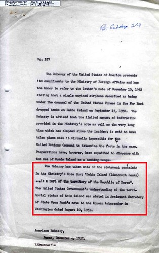
No. 187
The Embassy of the United States of America presents its compliments to the Ministry of Foreign Affairs and has the honor to refer to the latter’s note of November 10,1952 stating that a single engine airplane described as being under the Command of the United States Forces in the Far East dropped bombs on Dokto Island on September 15, 1952. The embassy is advised that the limited amount of information provided in the Ministry’s note as well as the very long time which has elapsed since the incident is said to have taken place make it virtually impossible for the United Nations Command to determine the facts in the case. Preparations have, however, been expedited to dispense with the use of Dokto island as a bombing range.
The Embassy has taken note of the statement contained in the Ministry's Note that "Dokdo Island(Liancourt Rocks)...is a part of the territory of the Republic of Korea". The United States Government's understanding of the territorial status of this islands was stated in Assistant Secretary of State Dean Rusk's note to the Korean Ambassador in Washington dated August 10, 1951.
American Embassy,
Pusan, December 4, 1952
As has told in the previous post, ROK government used the fact that U.S.’s suspension of the bombing on Liancourt Rocks after Korean fishermen/women were almost killed on 15th September, 1952. The document was thus included in the book for the purpose to reinforce their logic. However, Takeshima was finally decided to be released from bombing range by the U.S. & Japan Joint Committee on 19 Mar., 1953, not Korea-U.S. Committee, because of the petition by Shimane Prefecture.
Although Rusk Note went to public on April 1978, even today, Korean government keeps telling lies, such as Usando is Dokdo’s old name, to its own people and never stops illegal occupation on Japanese islets. The only way for innocent Korean people to escape from deception by its own government is to see the first-hand historical documents and old maps which are available on this blog.
The original idea of this “discovery” was brought by yabutarou and the photocopies of the book was provided by matsu. It was discussed on this blog on January 2010.
Related posts and links;
1946 - Jan 29 - SCAPIN 677
1946 - Feb 13 - "Conference with GHQ/SCAP concerning separation of the administration"
1946 - Jun 22 - SCAPIN 1033
1947 - Sep 16 -SCAPIN 1778
1949 - Nov 14 - Willam J. Sebald's telegram
1949 - U.S. Maps DOES NOT Confirm Korean Sovereignty Over Dokdo
1949 - Nov 14 - A letter from W. Walton Butterworth
1949 - Dec 29 - U.S. Draft made on December 29, 1949
1950 - July - Commentary on Draft Treaty by the Department of State
1950 - Aug 7 - U.S. Draft made on August 7, 1950
1950 - Oct 26 - USA Answers to Questions Submitted by the Australian Government
1951 - Apr - May: Joint UK and USA Draft - extra(1)
1951 - Jun 1 - New Zealand's view - extra(2)
1951 - Jul 6 - SCAPIN 2160 (cache)
1951 - Jul 9 - Coversation of Yu Chan Yang with John F. Dulles
1951 - Jul 19 - The 2nd Conversation between Yu Chan Yang and John F. Dulles
1951 - Jul 26 - the Japan-U.S. Joint Committee designated Takeshima as a bombing range for the U.S. Forces stationed in Japan. (official gazette of Japan)
1951 - Aug 2 - Another letter from You Chan Yang
1951 - Aug 3 - Bogg’s Memorandum (On re-ceiving Boggs's memo. I asked the Korean desk to find out whether anyone in the Korean Embassy officer had told him they believed Dokdo was near Ullengdo, or Takeshima Rock, and suspected that Parangdo was too.)
1951 - Aug 9 - Rusk's Letter ( As regards the island of Dokdo, otherwise known as Takeshima or Liancourt Rocks, this normally uninhabited rock formation was according to our information never treated as part of Korea and, since about 1905, has been under the jurisdiction of the Oki Islands Branch Office of Shimane Prefecture of Japan. The island does not appear ever before to have been claimed by Korea. )
1951 - Sep 9 - San Francisco Peace Treaty
1951 - Sep 21 - Korean Government comprehended Takeshima/Dokdo was affirmed as a Japanese Territory in Peace Treaty
1952- Jan 18 - Syngman Rhee Line
1950's - Japan & Korea Argue Their Claims in 1950s Letters
1952 - Jul 26 - The Japan-U.S. Joint Committee designated Takeshima as a bombing range for the U.S. Forces (The Ministry of Foreign Affairs published this fact in the official gazette.)
1952 - Nov 5 - Confidential Security Information of USA ("It appears that the Department has taken the position that these rocks belong to Japan and has so informed the Korean Ambassador in Washington." )
1952 - Dec 4 - Confidential Security Information of USA ( "I much appreciate your letter of November 14 in regard to the status of the Dokdo Island (Liancourt Rocks). The information you gave us had never been previously available to the Embassy. We had never heard of Deen Rusk’s letter to the Korean Ambassador in which the Department took a definite stand on this question.")
1952 - Dec 4 - “American Embassy’s Note Verbale No.187” - U.S. iterates Rusk Note to ROK.
(American Embassy in Busan gave South Korean Government an official notification that Takeshima is not Korean territory by reminding Dean Rusk’s Note on 9th August, 1951, which rejected Korea’s demand for Takeshima/Dokdo. )
1953 - Mar 19 - Japan U.S. Joint Committee decided to release Takeshima from the designation of a bombing range for the U.S. Forcese
1953 Jul 22 - Confidential Security Information of USA “Possible Methods of Resolving Liancourt Rocks Dispute between Japan and ROK”( The United States Government's understanding of the territorial status of this island was stated in assistant Secretary dated August 10,1951.")
1953 - Nov 30 - Secret Security Information of USA ("The Liancourt Rocks case appears to have aspects in common with that of Shikotan Island" "Remind the ROK of our previous statement of view (the Rusk letter)")
1953 - Dec 9 - SECRET SECURITY INFORMATION by Dulles
1953 - Jul 22 - US Doc. Reconfirms Dean Rusk Letter (Letter from Office of Northeast Asian Affairs To E. Allan Lightner American Embassy, Pusan Korea by L. Burmaster Office of U.S. Northeast Asian Affair )
1953 - Oct 13 - Daiichi-Daihou Maru Incident - the dispute over the Rhee Syngman Line
1954 - Aug - Report of Van Fleet mission to the Far East, 26 April - 7 August , 1954
2008 - Jul 30 - Press Briefing by Senior Director for Asian Affairs at the National Security Council, Dennis Wilder, on President's Trip to Asia (cache)
14.8.11
1952 - Dec. 4 - “American Embassy’s Note Verbale No.187” - U.S. iterates Rusk Note to ROK.
On 4th December 1952, American Embassy in Busan gave South Korean Government an official notification that Takeshima is not Korean territory by reminding Dean Rusk’s Note on 9th August, 1951, which rejected Korea’s demand for Takeshima/Dokdo.
On 9th July 1951, Korean Government was formally declined it's greedy demands for Tsushima by Ambassador Dulles. Instead, she suddenly asked for Dokdo/Takeshima and even non-existent Parang-do on 19th, 1951. However, the 3rd August’s note inside American Governmen reveals that Mr. Boggs, long-time Geographer to the Department of State, couldn’t identify the location of Dokdo and Parang-do despite trying all resources in Washington, and neither did Korean Embassy. As a consequence, Assistant Secretary of State Dean Rusk officially denied Korea’s inordinate demand for Takeshima/Dokd on 9th 1951.
Korean Government didn’t offer a counterargument concerning the sovereignty of the islands before the Peace Treaty was signed on September 8, 1951. However, On Sep. 21st, 1951, ROK again claimed Dokdo/Takeshima based on SCAPIN-677 MacArthur line and U.S.’s apology to Korea for the victims of 1948 bombing incident. But American Embassy in Pusan laughed off ROK’s empty comment, “we have substantial documented evidence to prove that the isle has been in the Korean possession for many hundred years”, which they couldn’t present any. The series of denial by America cornered ROK and she weiled the big stick after she finally realized that Takeshima/Dokdo has formally left to Japan by San Francisco Peace Treaty. ROK suddenly set Rhee Line in open waters, enclosing Dokdo/Takeshima inside Korean side.
As was stated in the note, it was issued in the response to the ROK’s protest against the bombing incident happened on 15th Sep. Some 23 Korean fishermen and women divers fishing on Takeshima/Dokdo narrowly escaped from bombs dropped by the airplane which returned to the direction of Japan afterwards. Consequently, a “scholarly exploration” party by Korean government couldn’t reach to Takeshima. It is no wonder since SCAP and U.S. government considered Takeshima was Japanese territory and U.S. and Japan joint committee designated Takeshima as bombing range for U.S.Forces.
Despite the fact that the islands are within the danger zone, the government of ROK not only didn’t take necessary steps to protect its own people dissuading fishermen/women from collecting shells on the islands but also even sent government lead “scientific expedition” whose “intent has obviously been to establish claim to Korean sovereignty over the rocks”. The similar incident had once happened in the June 8 of 1948. About 20 Korean were killed by the American bombing. In other words, ROK government took precedence its territorial ambitions over the life of its own people.
Next year, U.S. government ceased bombing because of the “crude implementation of Government control in Korea” and the U.S. and Japan “Joint Committee decided to release Takeshima from the designation of a bombing range for the U.S. Forces in March 1953”. Although the decision was made not only because of the incident, but because of petition by local people from Shimane on 20th May, 1952., Korean government soon started to take advantages of this cession as one of the proof U.S. ‘s recognition Korea’s sovereignty on the rocks.
This note is very important since Mr. Dennis Wilder, a Senior Director for Asian Affairs at the National Security Council, officially told that U.S. policy on this territorial dispute has been firm and consistent since 1952 during the press briefing on President's trip to Asia on July 30, 2008. “Our position since 1952” apparently means the U.S. position described in this official Note to ROK.
This note No. 187 had been referred many times in other U.S. documents such as “Letter from E. Allan Lightner American Embassy, Pusan Korea To Office of Northeast Asian Affairs, the Department of the State by E. Allan Lightner, December 4, 1952” or “Possible Methods of Resolving Liancourt Rocks Dispute between Japan and ROK, July 22, 1953.” Thus we did know that U.S. conveyed ROK their position (Takeshima/Liancourt Rocks are Japanese territory) second time. However, this is the first time we had an chance to see the document itself, since Korean government had not those unfavourable documents made open to the public.
The original of the document is from NARA, Box "322 Liancourt Rocks, 1952-54", Korea, Seoul Embassy, Classified General Records, 1952-63, RG 84 Records of the Foreign Service Posts of the Department of State,1788-1964.
Related Posts;
1946 - Jan. 29 - SCAPIN 677
1946 - Feb. 13 - "Conference with GHQ/SCAP concerning separation of the administration"
1946 - Jun. 22 - SCAPIN 1033
1947 - Sep. 16 -SCAPIN 1778
1949 - Nov. 14 - Willam J. Sebald's telegram
1949 - U.S. Maps DOES NOT Confirm Korean Sovereignty Over Dokdo
1949 - Nov. 14 - A letter from W. Walton Butterworth
1949 - Dec. 29 - U.S. Draft made on December 29, 1949
1950 - July - Commentary on Draft Treaty by the Department of State
1950 - Aug. 7 - U.S. Draft made on August 7, 1950
1950 - Oct. 26 - USA Answers to Questions Submitted by the Australian Government
1951 - Apr. - May: Joint UK and USA Draft - extra(1)
1951 - Jun. 1 - New Zealand's view - extra(2)
1951 - Jul. 6 - SCAPIN 2160 (cache)
1951 - Jul. 9 - Coversation of Yu Chan Yang with John F. Dulles
1951 - Jul. 19 - The 2nd Conversation between Yu Chan Yang and John F. Dulles
1951 - Jul. 26 - the Japan-U.S. Joint Committee designated Takeshima as a bombing range for the U.S. Forces stationed in Japan. (official gazette of Japan)
1951 - Aug. 2 - Another letter from You Chan Yang
1951 - Aug.3 - Bogg’s Memorandum (On re-ceiving Boggs's memo. I asked the Korean desk to find out whether anyone in the Korean Embassy officer had told him they believed Dokdo was near Ullengdo, or Takeshima Rock, and suspected that Parangdo was too.)
1951 - Aug. 9 - Rusk's Letter ( As regards the island of Dokdo, otherwise known as Takeshima or Liancourt Rocks, this normally uninhabited rock formation was according to our information never treated as part of Korea and, since about 1905, has been under the jurisdiction of the Oki Islands Branch Office of Shimane Prefecture of Japan. The island does not appear ever before to have been claimed by Korea. )
1951 - Sep. 9 - San Francisco Peace Treaty
1951 - Sep. 21 - Korean Government comprehended Takeshima/Dokdo was affirmed as a Japanese Territory in Peace Treaty
1952- Jan. 18 - Syngman Rhee Line
1950's - Japan & Korea Argue Their Claims in 1950s Letters
1952 - Nov. 5 - Confidential Security Information of USA ("It appears that the Department has taken the position that these rocks belong to Japan and has so informed the Korean Ambassador in Washington." )
1952 - Dec. 4 - Confidential Security Information of USA ( "I much appreciate your letter of November 14 in regard to the status of the Dokdo Island (Liancourt Rocks). The information you gave us had never been previously available to the Embassy. We had never heard of Deen Rusk’s letter to the Korean Ambassador in which the Department took a definite stand on this question.")
1953 Jul. 22 - Confidential Security Information of USA “Possible Methods of Resolving Liancourt Rocks Dispute between Japan and ROK”( The United States Government's understanding of the territorial status of this island was stated in assistant Secretary dated August 10,1951.")
1953 - Nov. 30 - Secret Security Information of USA ("The Liancourt Rocks case appears to have aspects in common with that of Shikotan Island" "Remind the ROK of our previous statement of view (the Rusk letter)")
1953 - Dec. 9 - SECRET SECURITY INFORMATION by Dulles
1953 - Jul 22 - US Doc. Reconfirms Dean Rusk Letter (Letter from Office of Northeast Asian Affairs To E. Allan Lightner American Embassy, Pusan Korea by L. Burmaster Office of U.S. Northeast Asian Affair )
1953 - Oct 13 - Daiichi-Daihou Maru Incident - the dispute over the Rhee Syngman Line
1954 - Aug. - Report of Van Fleet mission to the Far East, 26 April - 7 August , 1954
2008 - Jul. 30 - Press Briefing by Senior Director for Asian Affairs at the National Security Council, Dennis Wilder, on President's Trip to Asia (cache)
 No.187
The Embassy of the United States of America presents its compliments to the Ministry of Foreign Affairs and has the honor to refer to the latter's note of November 10, 1952 stating that a single engined airplane described as being under the command of the United States in the Far East dropped bombs on Dokdo Island on September 15, 1952. The Embassy is advised that the limited amount of information provided in the Ministry's note as well as the very long time which has elapsed since the incident is said to have taken place make it virtually impossible for the United Nations Command to determine the facts in the case. Preparations have, however, been expedited to dispense with the use of Dokdo Island as a bombing range.
The Embassy has taken note of the statement contained in the Ministry's Note that "Dokdo Island(Liancourt Rocks)...is a part of the territory of the Republic of Korea". The United States Government's understanding of the territorial status of this islands was stated in Assistant Secretary of State Dean Rusk's note to the Korean Ambassador in Washington dated August 10, 1951.
American Embassy,
Pusan, December 4, 1952
On 9th July 1951, Korean Government was formally declined it's greedy demands for Tsushima by Ambassador Dulles. Instead, she suddenly asked for Dokdo/Takeshima and even non-existent Parang-do on 19th, 1951. However, the 3rd August’s note inside American Governmen reveals that Mr. Boggs, long-time Geographer to the Department of State, couldn’t identify the location of Dokdo and Parang-do despite trying all resources in Washington, and neither did Korean Embassy. As a consequence, Assistant Secretary of State Dean Rusk officially denied Korea’s inordinate demand for Takeshima/Dokd on 9th 1951.
As regards the island of Dokdo, otherwise known as Takeshima or Liancourt Rocks, this normally uninhabited rock formation was according to our information never treated as part of Korea and, since about 1905, has been under the jurisdiction of the Oki Islands Branch Office of Shimane Prefecture of Japan. The island does not appear ever before to have been claimed by Korea. It is understood that the Korean Government's request that "Parangdo" be included among the islands named in the treaty as having been renounced by Japan has been withdrawn.
Korean Government didn’t offer a counterargument concerning the sovereignty of the islands before the Peace Treaty was signed on September 8, 1951. However, On Sep. 21st, 1951, ROK again claimed Dokdo/Takeshima based on SCAPIN-677 MacArthur line and U.S.’s apology to Korea for the victims of 1948 bombing incident. But American Embassy in Pusan laughed off ROK’s empty comment, “we have substantial documented evidence to prove that the isle has been in the Korean possession for many hundred years”, which they couldn’t present any. The series of denial by America cornered ROK and she weiled the big stick after she finally realized that Takeshima/Dokdo has formally left to Japan by San Francisco Peace Treaty. ROK suddenly set Rhee Line in open waters, enclosing Dokdo/Takeshima inside Korean side.
As was stated in the note, it was issued in the response to the ROK’s protest against the bombing incident happened on 15th Sep. Some 23 Korean fishermen and women divers fishing on Takeshima/Dokdo narrowly escaped from bombs dropped by the airplane which returned to the direction of Japan afterwards. Consequently, a “scholarly exploration” party by Korean government couldn’t reach to Takeshima. It is no wonder since SCAP and U.S. government considered Takeshima was Japanese territory and U.S. and Japan joint committee designated Takeshima as bombing range for U.S.Forces.
In July 1951, while Japan was still under Allied occupation, the Supreme Command for Allied Powers designated Takeshima as a bombing range for U.S. Forces by SCAPIN No. 2160. In July 1952, right after the San Francisco Peace Treaty came into effect, in response to the desire of the U.S. Forces to continue to use Takeshima as a training area, the Japan-U.S. Joint Committee established as the consultative body for the implementation of the Japan-U.S. Administrative Agreement (an agreement based on the former Japan-U.S. Security Treaty, which was succeeded by the current Japan-U.S. Status of Forces Agreement) designated Takeshima as a bombing range for the U.S. Forces stationed in Japan. The Ministry of Foreign Affairs published this fact in the official gazette. ( “Takeshima as a Bombing Range for U.S. Forces” by Japanese MOFA)
Despite the fact that the islands are within the danger zone, the government of ROK not only didn’t take necessary steps to protect its own people dissuading fishermen/women from collecting shells on the islands but also even sent government lead “scientific expedition” whose “intent has obviously been to establish claim to Korean sovereignty over the rocks”. The similar incident had once happened in the June 8 of 1948. About 20 Korean were killed by the American bombing. In other words, ROK government took precedence its territorial ambitions over the life of its own people.
Next year, U.S. government ceased bombing because of the “crude implementation of Government control in Korea” and the U.S. and Japan “Joint Committee decided to release Takeshima from the designation of a bombing range for the U.S. Forces in March 1953”. Although the decision was made not only because of the incident, but because of petition by local people from Shimane on 20th May, 1952., Korean government soon started to take advantages of this cession as one of the proof U.S. ‘s recognition Korea’s sovereignty on the rocks.
This note is very important since Mr. Dennis Wilder, a Senior Director for Asian Affairs at the National Security Council, officially told that U.S. policy on this territorial dispute has been firm and consistent since 1952 during the press briefing on President's trip to Asia on July 30, 2008. “Our position since 1952” apparently means the U.S. position described in this official Note to ROK.
This note No. 187 had been referred many times in other U.S. documents such as “Letter from E. Allan Lightner American Embassy, Pusan Korea To Office of Northeast Asian Affairs, the Department of the State by E. Allan Lightner, December 4, 1952” or “Possible Methods of Resolving Liancourt Rocks Dispute between Japan and ROK, July 22, 1953.” Thus we did know that U.S. conveyed ROK their position (Takeshima/Liancourt Rocks are Japanese territory) second time. However, this is the first time we had an chance to see the document itself, since Korean government had not those unfavourable documents made open to the public.
The original of the document is from NARA, Box "322 Liancourt Rocks, 1952-54", Korea, Seoul Embassy, Classified General Records, 1952-63, RG 84 Records of the Foreign Service Posts of the Department of State,1788-1964.
Related Posts;
1946 - Jan. 29 - SCAPIN 677
1946 - Feb. 13 - "Conference with GHQ/SCAP concerning separation of the administration"
1946 - Jun. 22 - SCAPIN 1033
1947 - Sep. 16 -SCAPIN 1778
1949 - Nov. 14 - Willam J. Sebald's telegram
1949 - U.S. Maps DOES NOT Confirm Korean Sovereignty Over Dokdo
1949 - Nov. 14 - A letter from W. Walton Butterworth
1949 - Dec. 29 - U.S. Draft made on December 29, 1949
1950 - July - Commentary on Draft Treaty by the Department of State
1950 - Aug. 7 - U.S. Draft made on August 7, 1950
1950 - Oct. 26 - USA Answers to Questions Submitted by the Australian Government
1951 - Apr. - May: Joint UK and USA Draft - extra(1)
1951 - Jun. 1 - New Zealand's view - extra(2)
1951 - Jul. 6 - SCAPIN 2160 (cache)
1951 - Jul. 9 - Coversation of Yu Chan Yang with John F. Dulles
1951 - Jul. 19 - The 2nd Conversation between Yu Chan Yang and John F. Dulles
1951 - Jul. 26 - the Japan-U.S. Joint Committee designated Takeshima as a bombing range for the U.S. Forces stationed in Japan. (official gazette of Japan)
1951 - Aug. 2 - Another letter from You Chan Yang
1951 - Aug.3 - Bogg’s Memorandum (On re-ceiving Boggs's memo. I asked the Korean desk to find out whether anyone in the Korean Embassy officer had told him they believed Dokdo was near Ullengdo, or Takeshima Rock, and suspected that Parangdo was too.)
1951 - Aug. 9 - Rusk's Letter ( As regards the island of Dokdo, otherwise known as Takeshima or Liancourt Rocks, this normally uninhabited rock formation was according to our information never treated as part of Korea and, since about 1905, has been under the jurisdiction of the Oki Islands Branch Office of Shimane Prefecture of Japan. The island does not appear ever before to have been claimed by Korea. )
1951 - Sep. 9 - San Francisco Peace Treaty
1951 - Sep. 21 - Korean Government comprehended Takeshima/Dokdo was affirmed as a Japanese Territory in Peace Treaty
1952- Jan. 18 - Syngman Rhee Line
1950's - Japan & Korea Argue Their Claims in 1950s Letters
1952 - Nov. 5 - Confidential Security Information of USA ("It appears that the Department has taken the position that these rocks belong to Japan and has so informed the Korean Ambassador in Washington." )
1952 - Dec. 4 - Confidential Security Information of USA ( "I much appreciate your letter of November 14 in regard to the status of the Dokdo Island (Liancourt Rocks). The information you gave us had never been previously available to the Embassy. We had never heard of Deen Rusk’s letter to the Korean Ambassador in which the Department took a definite stand on this question.")
1953 Jul. 22 - Confidential Security Information of USA “Possible Methods of Resolving Liancourt Rocks Dispute between Japan and ROK”( The United States Government's understanding of the territorial status of this island was stated in assistant Secretary dated August 10,1951.")
1953 - Nov. 30 - Secret Security Information of USA ("The Liancourt Rocks case appears to have aspects in common with that of Shikotan Island" "Remind the ROK of our previous statement of view (the Rusk letter)")
1953 - Dec. 9 - SECRET SECURITY INFORMATION by Dulles
1953 - Jul 22 - US Doc. Reconfirms Dean Rusk Letter (Letter from Office of Northeast Asian Affairs To E. Allan Lightner American Embassy, Pusan Korea by L. Burmaster Office of U.S. Northeast Asian Affair )
1953 - Oct 13 - Daiichi-Daihou Maru Incident - the dispute over the Rhee Syngman Line
1954 - Aug. - Report of Van Fleet mission to the Far East, 26 April - 7 August , 1954
2008 - Jul. 30 - Press Briefing by Senior Director for Asian Affairs at the National Security Council, Dennis Wilder, on President's Trip to Asia (cache)
Subscribe to:
Comments (Atom)