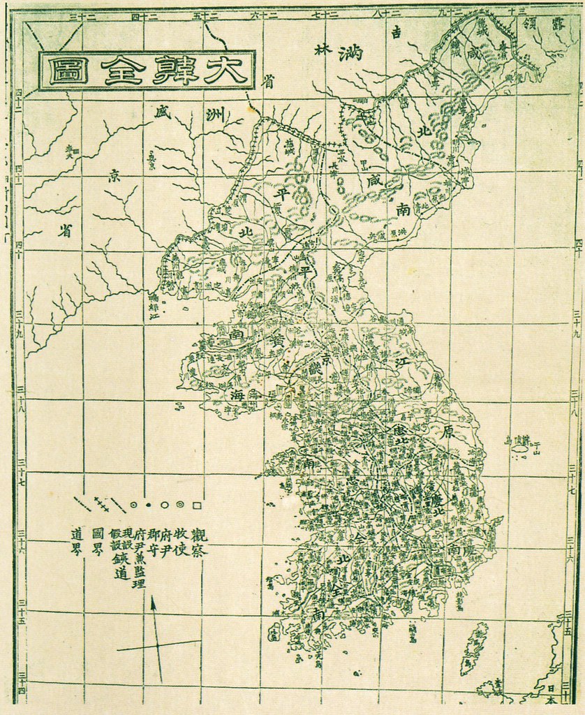
 The Korean map below was included in the 1899 edition of the "Daehanjiji (大韓地誌), which was a Korean geography book written by Hyeon Chae (玄采). The book was published in two volumes, of which the cover of the first volume is pictured on the left. The book is comprised of thirteen chapters, excluding the introduction. The thirteen chapters describe the geography, history, economy, and other features of the thirteen provinces that made up Korea at the time. A Map of each province was also included in each chapter. The forward (序) of the book was written by Lee Gyu-hwan (李圭桓), who was the director of the editorial office for Korea's Ministry of Education (學部) at the time. The Korean map below was placed in the front of the book, before the introduction. The map is called the "Daehan Jeondo" (大韓全圖), which means "Complete Map of Korea."
If you look at Ulleungdo (鬱陵島) on the map, you will notice a small neighboring island off its east shore labeled as "于山" (Usan). Korean historians claim that Usando (于山島) was the old Korean name for "Dokdo" (Liancourt Rocks), but the map below shows that "Usan" was just a neighboring island of Ulleungdo. The lines of longitude on the map show Ulleungdo and its neighboring island of Usan to be between the 130 (三十) and 131 degree lines of east longitude. That would exclude the island labeled as "Usan" on the map from being Liancourt Rocks (Dokdo) since Liancourt Rocks is located east of the 131 degree longitude line at 131 degrees 52 minutes. There are sixty minutes in a degree of longitude, which means that Liancourt Rocks are located very close to the 132 degree line.
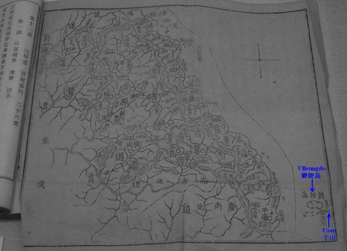
The following is a map from the chapter on Gangwon Province from the 1901 edition of the "Daehanjiji (大韓地誌). Ulleungdo (鬱陵島) appears on the map because it was considered a part of Gangwon Province in 1901. If you look at Ulleungdo on the map, you should notice that this map also shows "于山" (Usan) as a neighboring island of Ulleungdo, not as Liancourt Rocks (Dokdo). In fact, Usando (于山島) was never shown as Liancourt Rocks (Dokdo) on any map, Korean or Japanese.
Great, Gerry.
ReplyDeleteThis is the firm evidence that Seokdo in the 1900 ordinance was not Liancourt rocks.
Gerry, is there a map of 江原道 in the chapter of 江原道? Does it contain the same figure of Ulleungdo and Usan?
Pacifist,
ReplyDeleteI do not have a map of Gangwon Province (江原道) from the 1899 edition of the book, but I have added an image from the 1901 edition, which also shows "Usan" (于山) as a neighboring island of Ulleungdo, not as Liancourt Rocks (Dokdo).
It is not sure that the caption and year is correct or not, there is some map in 大韓地誌or 新大韓地誌
ReplyDelete1899.大韓全図(whole map)
1899.大韓全図 江原道It seems similar with 1901 edition
1899.大韓全図 慶尚道図
1907.大韓新地誌 慶尚北道図
1907.大韓新地誌(Whole map)
1909.最新高等大韓地誌
There is some other interesting maps below;
1900c.a 大韓與地図
The shape of Ullungdo is similar like 大韓地誌 1899edition?
1896江原道図
1913.朝鮮遊覧図 Im much interesting in the charactor inside Ulleungdo.
Thank you, GTOMR.
ReplyDelete1899.大韓全図(whole map)
1899.大韓全図 江原道
1899.大韓全図 慶尚道図
1907.大韓新地誌 慶尚北道図
1907.大韓新地誌(Whole map)
They are all in colur!!
I can't see clearly of 鬱陵島 in 1909 最新高等大韓地誌, but it looks like there is no 竹島/Liancourt Rocks/Dokdo on tha map. From 1899 to 1909, Korean geograph textbook doesn't include 竹島/Liancourt Rocks/Dokdo wihin their territory. Can you read what it says on Ulleundo in 1913 朝鮮遊覧図?
Anyone can confirm the contents of this text below?
ReplyDelete1899.海東志
位置?面積?地勢?地味?島嶼?港灣?潮汐?山嶽?江河?原野?氣候 ?? ???
<江原道>: 凌波臺?弓裔古都?召公臺?子規樓?天王祠??花巖?鶴浦橋?埋香碑?葛山洞?文殊寺?石穴?甲川?看藏寺?積穀蛤?鑑浦?祭堂淵?孤石峯?楓川原?菩提坂?穆祖舊居?昭陽江?貊國?大關嶺?大嶺?侍中臺?處士臺?合江亭?酒泉?頭陀山?寒松亭?牛首渚? 國? 原城?東海碑?寒溪山?三釜瀑?五臺山?太宗臺?於羅寺淵??花峯?聖留窟?三鶴山?石窟,
<位置>???? ????? ????? ‘土門江’?? ????
This comment has been removed by the author.
ReplyDeleteGerrt Bevers,
ReplyDeleteHow about Ulleongdo? The longitude of Ulleongdo is 130 degrees 54 minutes. Ulleongdo is also located at the inaccurate longitude in the map of 大韓全圖. How can you explain about this? Why don't you say Ulleogndo in the map is not today's Ulleongdo because it's not at the right longitude?