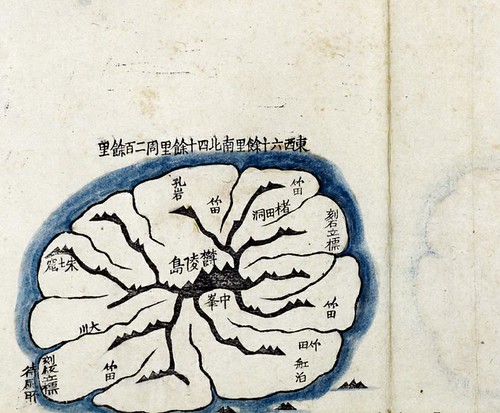
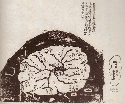
Below is another map of Ulleungdo, which looks to be a copy of Kim Jeong-ho's 1861 "Daedong Yeojido" Ulleungdo map shown above, but notice that Usando is added to the map below, as well as other information about Ulleungdo. Supposedly, Mr. Kim revised parts of his 1861 "Daedong Yeojido" map in 1864, so the map below is probably a copy of that revised version.
The writing in the uppper part of the map was also written on Kim Jeong-ho's 1834 "Cheonggudo" map and translates as follows:
In the 11th year of Yeongjo (1735), Gangwon Provincial Governor Jo Choi-su reported to the king, ‘A survey of Ulleungdo has found that the land is wide and fertile, and there are signs that people have lived there. Also, to its west is Usando, which is also wide and spacious.’ The so-called “west” character is different on this map, where (Usando) is to the east.The above map is from Lee Sang-tae's book, "Historical Evidence of Korean Sovereignty over DOKDO. Notice that below the neighboring island labeled as "于山" (Usan), Professor Lee typed "Usando (Dokdo)," which means he is claiming that the neighboring island is "Dokdo" (Liancourt Rocks). The map, however, shows Usando as "one" island right next to Ulleungdo, which means the Usando on this map was not "Dokdo" since Dokdo is ninety-two kilometers southeast of Ulleungdo and is essentiallly made-up of two islets, not one. This is another example of a Korean scholar blindly ignoring the evidence to claim that "Usando" was an old Korean name for Dokdo (Liancourt Rocks); however, the above map shows, once again, that Usando was just a neighboring island of Ulleungdo, not Dokdo.
????.東輿圖(He study this map when he produce 靑邱圖,but found.)
ReplyDelete1834.靑邱圖(Gerry post before)
1856-59?.東輿圖. 15-1
1859-65?.(大)東輿(地圖)(new copy of ????東輿圖)韓国国立博物館.
in the list,no 3
1861.大東輿地圖 金正活 韓国国立中央図書館 古朝61-1
1861.大東輿地圖 金正活 copy 1(post above))
1861-63.大東方輿全圖 金正活 Kyujanggak 15-3
1864.大東輿地圖(筆写本)revised copy with 于山島(post above)
???? 朝鮮古分道地圖 三 高麗大学図書館
1860-72.靑邱圖(copy version)高麗大学図書館
if there are another series of Kim's map,plz advise us!
This comment has been removed by the author.
ReplyDeleteSorry for double post.
ReplyDeleteI remember that 1834.靑邱圖 is succeed from 海東輿地圖(1776-1795c.a,古2107-36)
But,reading the CBS news, they said kim studied 東輿圖 when he produced 靑邱圖.
the 東輿圖 in the link above is considered the copy map that he studied and it is in the dokdo museum catalogue no.3 above and in the Koeran national museum.
Now I remember it is resemble map with 海東輿地圖(1776-1795c.a,古2107-36)that there are 東輿圖(朝鮮古圖・1795-1800c.a)in the Tsukuba univ library that Yabutarou introduced.
GTOMR,
ReplyDeleteKim Jong-ho made three maps: "Cheonggu-do" (靑邱圖 - 1834), "Dong Yeodo" (東輿圖 - 1851 ~ 1856), and "Daedong Yeojido" (大東輿地圖 - 1861). The "Cheonggu-do" and "Dong Yeodo" maps were drawn by hand, which means they were not made for mass production. The "Daedong Yeojido," however, was craved on wooden print blocks to allow for mass production.
Kim's "Dong Yeodo" map was obviously an update of his "Cheonggu-do," and had much more detail than both the "Cheonggu-do" and the "Daedong Yeojido." The most likely reason it had more detail than his "Cheonggu-do" was that it was an updated map, and the most likely reason it had more detail than the "Daedong Yeojido" is that the "Daedong Yeojido" was a woodblock print map, which means it was harder to crave out detail than to draw it in. So, yes, Kim Jeong-ho obviously made his "Daedong Yeojio" map from his "Dong Yeodo" map, especially when you consider that the "Daedong Yeojido" was made very soon after the "Dong Yeodo."
After he made each of his maps, Kim also made geography books, which explained the details of the different regions of his maps.
I have read that there are nine copies of the "Cheonggu-do" still in existence, and that there are three versions of the map.
I hope that answered your question.