竹島問題の歴史

31.12.10

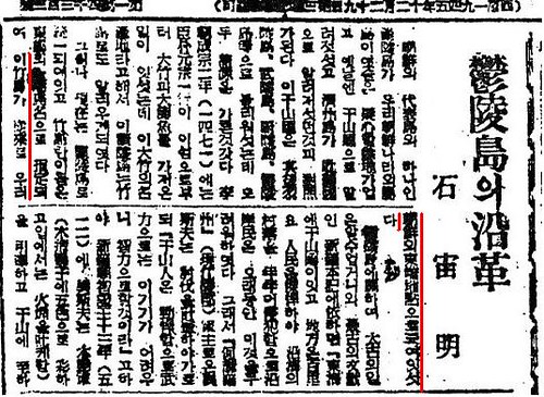
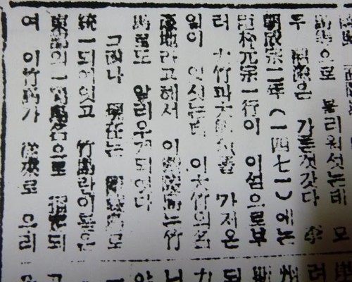
1947 - Sep. 2 - Sok Ju-myong(石宙明)'s "History of Ulleungdo " says that Jukdo has been the eastern edge point of Joseon.

In Sep. 2nd article of Seoul Shinmun in 1947, Korean scientist Mr. Sok wrote a report about the history of Ulleungdo, where he just came back from. He and his colleagues went to Ulleungdo after Korean interim government heard that, on April 1947, some Japanese came to Takeshima and told the Korean poachers who were fishing on Takeshima without any permission nor fishing rights to stay away.
石宙明1947 鬱陵島の沿革 ソウル新聞 1947(赤線)1947 鬱陵島の沿革 ソウル新聞 1947(補充・再掲)
On receiving the news, Korean interim government asked Korea Alpine Association to send research group to Ulleungdo furtively to collect the evidences to show Takeshima/Dokdo was their territory. Some Korean officials accompanied them. It was the time of the origin of Korea's illegal occupation of Takeshima/Dokdo which Korea had any historical documents nor maps to support their claim that the island was theirs since 512 A.D. As Mr.Sok clearly wrote in his report, the eastern limit of Korea/Joseon have been Ulleungdo, more precisely, the island of Jukdo(竹島, Japanese name 竹嶼), not today's Takeshima/Dokdo. Traditionally/historically, Takeshima/Dokdo was outside of their territory apparently.
Indisputably, Ulleungdo(鬱陵島), which is one of Joseon's representative islands, had belong to our country Joseon, and it was known as Usando before, just as Jeju island was known as the country of Tamra(耽羅) in contrast. Usando had been called such as U-leung(羽陵)do, Mulleung(武陵)do, Ulleung(蔚陵)do or Ulleung(鬱陵)do afterwards. However, it seems that the etymologies are all the same. In 1471, the second year of King Seongjong, a retainer Park Wonjong(朴元宗) and his party once went to the island and had brought huge bamboos and abalones back, so the island of Ulleungdo got to be known as Jukdo(竹島) since the location was famous for production of the huge bamboos.
However, the name of the island was standardized as Ulleungdo now, and the name of Jukdo(竹島) was assigned to a adjacent island on East part, and this Jukdo had been the eastern edge point of our Joseon historically.
As we know, this Jukdo(竹島) shares same Chinese caracter with Japanese Takeshima(竹島), but they are completely different islands. Jukdo, which locates 2-4 km east of Ulleungdo, which is definately the island Mr. Sok mentioned in the report, was the adjacent island of Ulleungdo, was the easternmost of Korea. On the other hand, Takeshima, which locates 92km southeast of Ulleungdo, was Japanese territory since they incorportated it into Shimane prefecture officially in 1905.

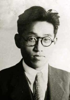
Sok Ju-myong(石宙明) was a Korean butterfly specialist and he was a director of zoology division of National Science Museum. He was born in Pyongyang in 1908 and later, went to Ibusuki Experimental Botanical Garden(鹿児島高等農林学校) in Japan.

Although he accompanied the party as a member of the Korea Alpine Association in 1947 to collect the evidences to show Takeshima/Dokdo was Korea's territory, he missed the tour to Takeshima/Dokdo since he lost his way when he went to Saint Peak(聖人峯) and couldn't be on time. Maybe, that was the reason he honestly wrote the fact that Jukdo was the easternmost of Korea before he got to know Takeshima/Dokdo was not inside their territory, since he didn't know where today's Takeshima/Dokdo was in reality. In fact, he lost his integrity and distorted the historical fact of the Korea's eastern limit just a week after he wrote this report. On 9th Sep. article, he wrote "Dokdo is within our territory", to my surprise.

As we have seen so far, after 1947, Korean distorted the historical facts and build up their theory that Takeshima/Dokdo had been within their territory since 512 A.D., though there is absolutely no historical maps/documents to support their claim. The two articles Mr. Sok wrote in 1497 illustrates the origin of this Korea's fabrication on Takeshima/Dokdo claim and prove how they had distorted the historical fact of their own in order to expansion their territory militarily.

This post was written based on the excellent work of our commentator Chaamiey and Makoto. You can read the details in Japanese on chaamiey's site.

鬱陵島の沿革 ソウル新聞 1947
鬱陵島の沿革 ソウル新聞 1947(補充・再掲)

References;


「再説・石宙明(ソク・ジュミョング)」 SEOK D.M. (Sok Ju-myong) revisited(Japanese)
Korea's Post-Liberation View on Dokdo and Dokdo Policies (1945 - 1951). JUNG Byungjoon
22.12.10

Exhibition of "Dokdo" Maps & Docs in Busan

A special exhibition of "Dokdo" related antique maps and documents is being held at the Busan Exhibition and Convention Center (BEXCO) from December 21 to 26. The exhibition will also include photographs and models of the island and the surrounding area. In all, more than 150 items will be on display.

Busan Exhibition and Convention Center

8.12.10

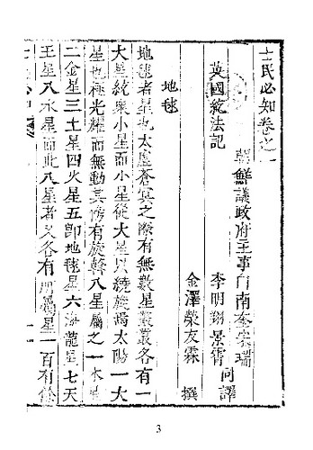
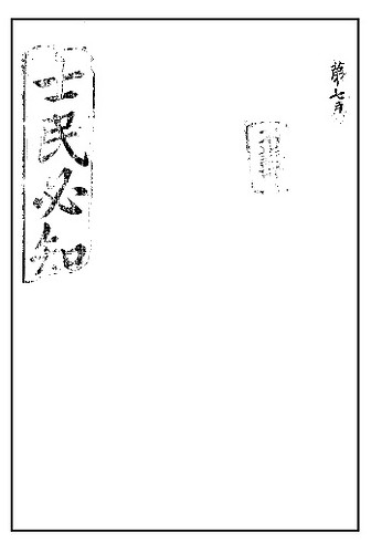
1895 - 紇法『士民必知』 (Knowledge Necessary for All) excluded Takeshima from the Country of Korea.

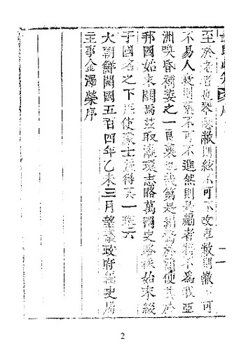
1895 『士民必知』_表紙1895 『士民必知』_2 翻訳序1895 『士民必知』_4

『士民必知』(1895) is the Chinese translation of Homer Hulbert's "Knowledge Necessary for All"(1889 or 1891-1895) by Baek Nam-gyu(白南奎) and Lee Myeong-sang(李明翔), and both of them are government officials of State Council of Joseon(議政府主事). It says "The easternmost of the Country of Korea is 131° E." , while Takeshima/Liancourt Rocks is at 131°52′ E. , 37°14′ N. in the section of 朝鮮(Korea). Moreover, it cleary states that the easternmost islands of Joseon is Ulleungdo.

朝鮮
 唐堯時有壇君始立国歴箕子或分或合今為
 本朝李氏自太祖至今凡五百四年
朝鮮国者幅圓自北緯線三十五度至四十三度自
東経線一百二十三度至一百三十一度南北三千
里東西六百里其界北満州東日本海南南海西渤
海地方十里者九千五百地形四面多山而東北有
白頭山最大為諸山之祖其水南有洛東江錦江西
有大同江西北有鴨緑江其港東北曰元山東南曰
釜山西南曰仁川其島南曰濟洲東曰鬱陵西南曰
江華...
----------------------------------------------
Joseon
King Dangun established the country during the time of the reign of the Chinese Emperor Yao. In its history, Gija sometimes splitted or merged the country into present. Current Dynasty is Lee and it is about 504 years from the first king, Taejong.

The Country of Korea lies from 35° N. to 43° N., and from 123° E. to 131° E. From south to north, it's 3000-ris and from east to west, it's 600-ris. The boundry of the country is Manchuria on the north, the Sea of Japan on the east, South Sea on the south and Balhae on the west. The area of the country is 9500(ris) and its topography is full of mountains. There is Baekdu Mountain, which is the biggest and the origin of all the mountains. As for the rivers, there are Nakdong River and Guem River on the south, Taedong River on the west and Yalu River on the north-east. The ports are Wonsan on the north-east, Pusan on the south-east and Incheon on the south-west. As for the islands, there is Jeju on the south and Ulleung on the east and Ganghwa on the south-west ..

Hulbert(紇法) wrote this geography textbook in Korean Hangul and "it became the first standard textbook in Korean in Korea used by all schools in Korea", while Joseon officials translated it into Chinese(!?) and published it. The book is about the world geography.
Homer B. Hulbert first stepped on Korean soil in 1886 as a teacher for Royal English School(育英公院), which was the first government school in western style. The school introduced western fields of learning in its instruction such as English language, history, natural sciences, geography and mathematics.

Hullbert discovered that the school needs a world geography, and in 1891 published a book entitled "Sa-Min Pil-Ji(Knowledge Necessary for All)", which served as a primer for geography, astronomy and introduction of social systems, industries of all the countries. This book became the first standard textbook in Korean in Korea used by all schools in Korea. (The Hulbert Memorial Society)
The last part of preface says that "大朝鮮開國五百四年乙未三月望議政府編史局主事金澤榮序" , meaning that Kim T'aek-yong, the historian and poet who worked for the division of history compilation of the State Council of Joseon, wrote this preface at the 504th year of the country of Great Joseon. According to Choson Shinbo(朝鮮新報), Kim was known for an anti-Japan activist and deplored to Japan, defected to China in 1908, and participated in the anti-Japanese movement. A lot of patriotism works were left.

As we have studied on this site, it is apparent that westerners like Hulbert who even defied Japan's control over Korea, as much as then Korean government, considered that the eastern most of Korea was Ulleungdo, not today's Takeshima/Liancourt Rocks.

The information of the book was originally introduced by GTOMR. Thank you.

References;
1884~1894 - Map of Ulleungdo (鬱陵島) & Usando (于山島)
(it shows an island off the east shore of Ulleungdo (鬱陵島) labeled as "Udo" (于島))
1893 - "Yeoljae Chwalyo" (輿載撮要 - 여재촬요) - Map of Samcheok (三陟) and Ulleungdo (鬱陵島) 
1898 - Korean Map of Gangwondo & Ulleungdo
(地圖 江原道 咸鏡道)
1899 - Korean Map: "Daehanjeondo" (大韓全圖)
(玄采 大韓地誌)
1899 -
"Takeshima in the Korean official map" by Funasugi Rikinobu (舩杉力修) - (5) 『大韓全図』(1899) , 『大韓輿地図』(1900 c.a.)
1899 - Sep 23 - "Hwangseong Sinmun" (皇城新聞) 1899 Sep 23: Ulleungdo Situation
1900 - "Uldo-gi" (鬱島記), by U Yong-jeong (禹用鼎)

1900 - Oct. 22 - A petition by 李乾夏 "鬱陵島를鬱島로改稱하고島監을郡守로改正에關한請議書", which excluded Dokdo from Uldo County.

1900 - Imperial Edict Makes Ulleungdo a County of Gangwon Province
(大韓勅令第41号)
1901 - "Daehanjiji" (大韓地誌) Map of Korea's Gangwon Provin
ce (玄采)
1906 - Feb 20 & April 17 - "Official Documents of the Ministry of Internal Affairs Vol.1" - Korean government protested about land transaction in 竹邊浦

1906 -
July - Korea Omits Dokdo from Uldo County (皇城新聞 「鬱島郡의 配置顛末)
1906 - "Daehan Jiji" (大韓地誌) by Hyeon Chae (玄采)

Korean Eastern limits described in various books world wide exclude Takeshima/Dokdo from Korean Territory
The Territorial Recognitions which Western Maps of Japan Show for Takeshima/Liancour Rocks between 1880-1905 : Ver.1

1951 - August - Rusk's Letter - (A letter to the Korean Ambassador from US Secretary of State Dean Rusk ) ( As regards the island of Dokdo, otherwise known as Takeshima or Liancourt Rocks, this normally uninhabited rock formation was according to our information never treated as part of Korea and, since about 1905, has been under the jurisdiction of the Oki Islands Branch Office of Shimane Prefecture of Japan. The island does not appear ever before to have been claimed by Korea. )

1953 - Jul 22 - US Doc. Reconfirms Dean Rusk Letter (Memorandum by Mr. Robert A. Fearey of the Office of Northeast Asian Affairs) (With regard to the question of who has sovereignty over the Liancourt Rock (which are also known in Japanese as Takeshima, and in Korean as Dokdo), it may be of interest to recall that the United States position, contained in a note to the Republic of Korea's Ambassador date August 10, 1951 reads in part:
"....As regards the island of Dokdo, otherwise known as Takeshima or Liancourt Rocks, this normally uninhabited rock formation was according to our information never treated as part of Korea and, since about 1905, has been under the jurisdiction of the Oki Islands Branch Office of Shimane Prefecture of Japan. The island does not appear ever before to have been claimed by Korea......")
1954 - Report of Van Fleet mission to the Far East (A secret report drafted by James Van Fleet, a US special mission ambassador, to U.S. President )the United States concluded that they remained under Japanese sovereignty and the Island was not included among the Islands that Japan released from its ownership under the Peace Treaty.

1.11.10

Samcheok Museum Map dated 1884 - 1888?

The map shown below is an old, undated inspectors map of Ulleungdo that is on display at the Samcheok (三陟) Municipal Museum. It shows Ulleungdo with two neighboring islands labeled as "Big Udo" (大于島 - 대우도) and "Small Udo" (小于島), which represented Ulleungdo's neighboring islands of Jukdo (竹島 - 죽도) and Gwaneumdo (觀音島 - 관음도), respectively. It also lists, on the map, the titles and numbers of people who were part of the inspection team during that particular inspection. The leader of the inspection team was listed by his title, "Yeongjang" (營將).

From 1884 to 1888, a Korean official with the title of "Samcheok Yeongjang" (三陟營將 - 삼척영장) was charged with inspecting Ulleungdo. The fact that the map below lists the leader of the inspection team as "Yeongjang" (營將) and that it is, in fact, displayed in the "Samcheok" museum suggest the map was made sometime between 1884 and 1888.

Another reason I believe the map was made between 1884 and 1888 is that it showed and named Ulleungdo's two neighboring islands, which was done on only two other old Korean maps. One of the other maps was Inspector Lee Gyu-won's 1882 map of Ulleungdo. I believe that the map below was made after 1882 since it seems to have adopted Inspector Lee's new concept of viewing Gwaneumdo (觀音島 - 관음도) as an island rather than as a promontory.


The above map can be found on Tanaka Kinitaka's Web site at the following address:

http://www.tanaka-kunitaka.net/takeshima/samcheok/

31.10.10

1893 Map of Samcheok (三陟) and Ulleungdo (鬱陵島)

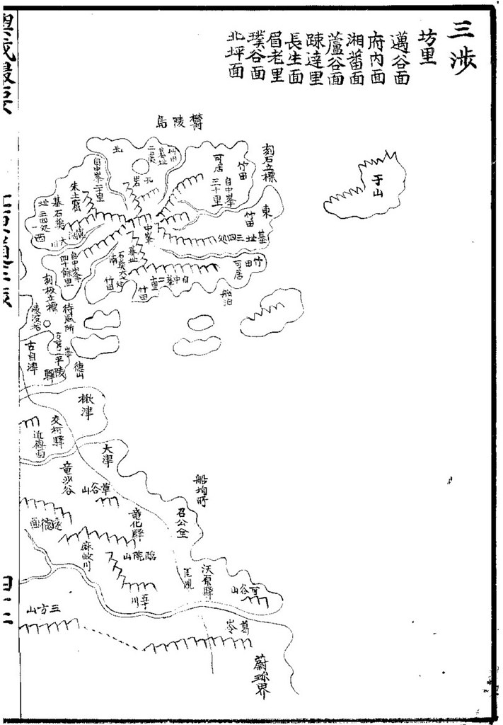
Below is a map of Samcheok (三陟 - 삼척) and Ulleungdo (鬱陵島 - 울릉도), from the 1893 atlas "Yeoljae Chwalyo" (輿載撮要 - 여재촬요). The map shows that Ulleungdo was associated with Samcheok in 1893. The map also shows a single island off Ulleungdo's east shore labelled Usan (于山). Usan was the old Korean name for Ulleungdo's neighboring island of Jukdo (竹島), which is 2 kilometers off Ulleungdo's east shore.

The map is important because it shows that Ulleungdo's neighboring island of Jukdo was still being referred to as Usando in 1893, ten years after Ulleungdo was opened to settlement.


Below is a similar map, which was made sometime between 1888 and 1894.


Thanks, GTOMR, for telling me about the 1893 map.

30.10.10

Joseon Paldo Jido (朝鮮八道地圖) - Ulleungdo (鬱陵島)

The following is a map of Ulleungdo, from a book entitled "Joseon Paldo Jido (朝鮮八道地). It is a cutout from a map of Pyongando (平安道), Hwanghaedo (黃海道), and Gangwondo (江原道). As far as I know, the date of the map is unknown. The map is stored in the Kyujanggak Institute for Korean Studies at Seoul National University.

Notice that it shows a small island just off the east shore of Ulleungdo labelled 于山 (Usan). Today, Koreans call the island Jukdo (竹島 - 죽도), which is about two kilometers off Ulleungdo's northeast shore. Some Koreans claim that Usan was the old Korean name for Liancourt Rocks (Dokdo / Takeshima), but there is no Korean map or documentary evidence to support the claim.


Let me know if this map has already been posted here.

28.10.10

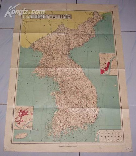
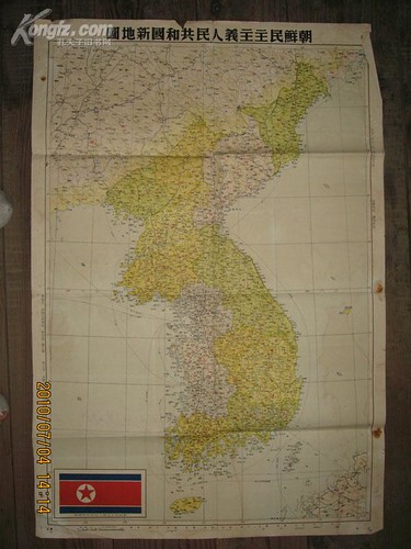
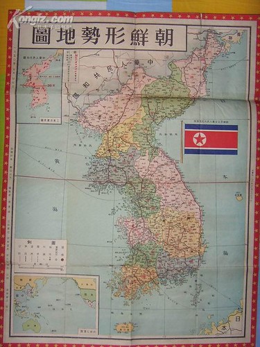
1950 -中央人民政府人民革命軍事委員会作戦部測絵局 『朝鲜地图』 - People's Republic of China excluded Takeshima/Dokdo from " Map of Korea"

It looks like 中華人民共和国 (People's Republic of China) considered Ulleungdo is the easternmost of Korea.

1950.09.朝鲜地图 中央人民政府人民革命軍事委員会作戦部測絵局 新華書店
1950 Sep. 朝鲜地图 中央人民政府人民革命軍事委員会作戦部測絵局 新華書店

1950.朝鮮民主主義人民共和国新地圖 中国史地学社刘思源、董石声编制,金擎宇校订
1950 朝鮮民主主義人民共和国新地圖 中国史地学社刘思源、董石声编制,金擎宇校订

1950.07.28 最新朝鲜形势地图(1950年7月28日初版) 上海 百新书店 新文化书社 锦章书局 联合出 编绘者 杨景雄
1950 Jul. 28 最新朝鲜形势地图 上海 百新书店 新文化书社 锦章书局 联合出 编绘者 杨景雄

Thanks for the information, GTOMR !!

1.10.10

Are Koreans still interested in "Dokdo"?

In August 2009, the hit counter for this site showed more than 1.1 million hits, most of which were probably from Koreans coming to this site to vote in an online survey asking if Liancourt Rocks (Takeshima/Dokdo) belonged to Korea or Japan.

Before 2009, there was a great deal of Korean media and public interest in the Takeshima/Dokdo dispute, with almost weekly reports on Korean "Dokdo" protests or on some "newly discovered" map supposedly "proving" Korean claims, but that all but ended in 2009. Now the Korean media and Dokdo advocates have pretty much gone silent on Dokdo. Why? And what has happened over the past year?

Sometime in September 2009, our hit counter mysteriously reset itself from about 1.1 million hits to about 12,000. Today, our hit counter shows over 100,800 hits, which means that over the past year, this site has had about 88,000 hits. That averages out to about 240 hits a day for the past year, which is a pretty respectable hit count. Therefore, there still seems to be some interest in the Takeshima/Dokdo dispute, but it seems to be silent interest on Korea's part. Koreans and their Dokdo advocates no longer come to this site to argue Korea's silly claims. Why? Probably because they no longer believe them, though they will probably never admit it.

I think the Korean media and Korea's Dokdo advocates have gone silence on "Dokdo" because they and the Korean government finally came to realize that making "Dokdo" an issue was hurting Korea more than helping her. Thanks to this site and others, Korean historical claims on Dokdo have been shown to be false by using Korea's own documents and maps. Few Koreans are still arguing Korea's wild Dokdo claims because evidence disproving such claims is now scattered all over the Internet.

Japan may never get back the islands that Korea illegally occupied in the 1950s, but, at least, the world is slowly coming to realize the truth about Korea's false historical claims.

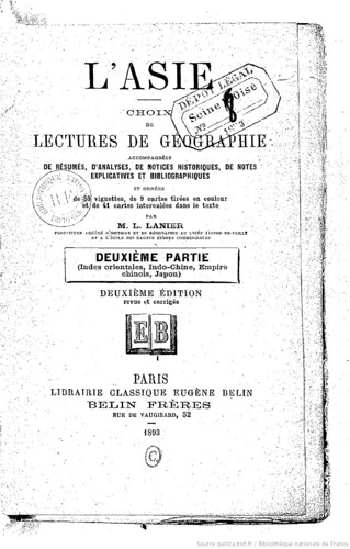
1893 - Lanier "L'Asie" excluded Takeshima/Liancourt Rocks (Dokdo) from Korean territory

1893 L'Asie, choix de lectures de géographie... par M. L. Lanier
This French book of Geography "L'Asie, choix de lectures de géographie-Deuxième Partie" was written by Lanier, Lucien (1848-1908) in 1893. (There are more editions as 1892, 1908 on Google books.)

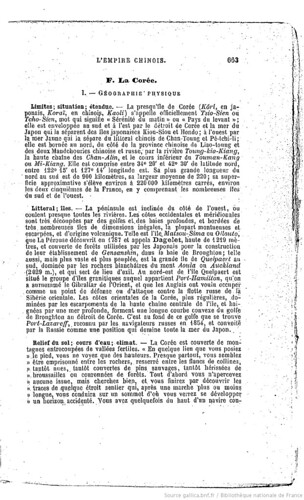
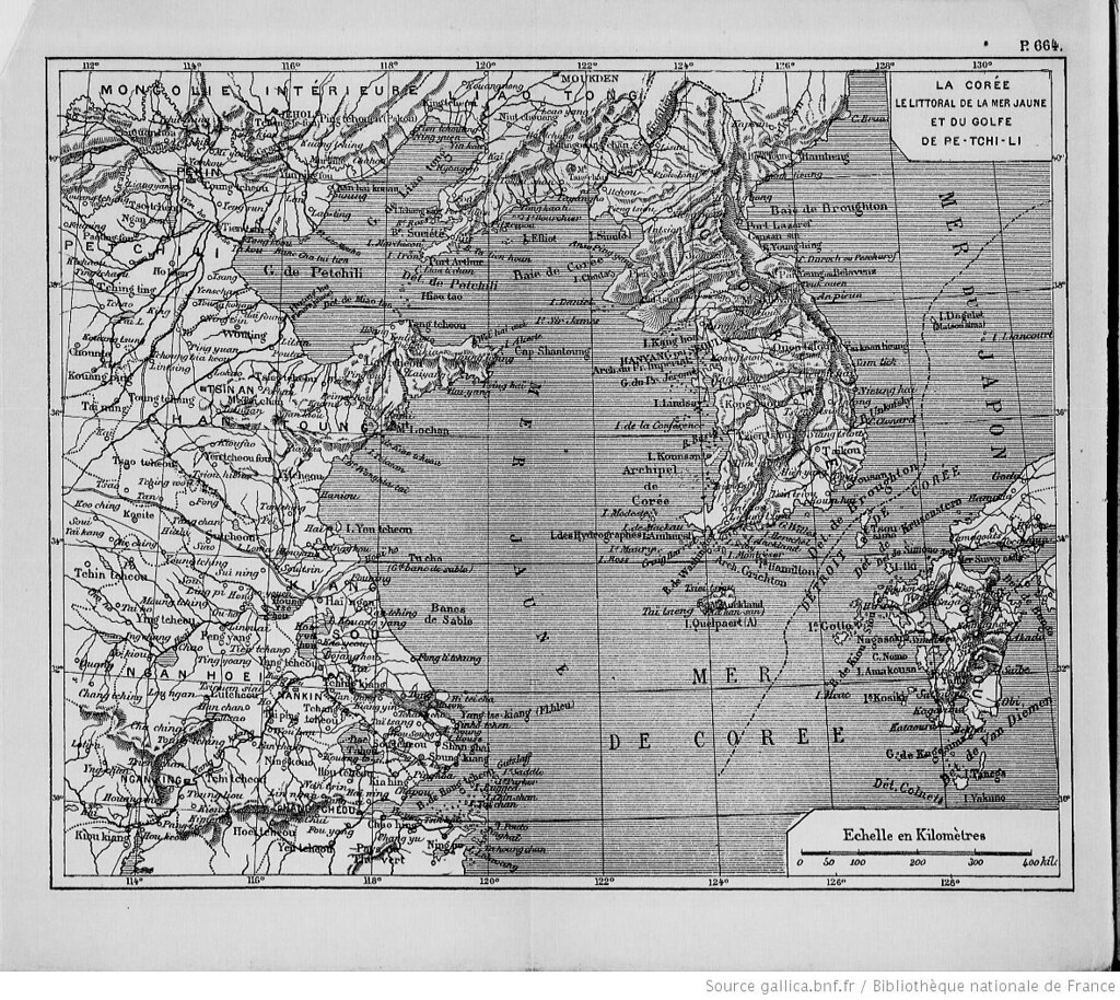
The description of the Korean geography only describes "Korean peninsula", but the description of the "islets", as shown below, included Dagelet/Ulleungdo/Matsushima, but not "Liancourt Rocks" which was found and named by French in 1949. However, the map attached to the book clearly excluded Liancourt Rocks from Korean territory. Apparently, the author Lanier considered Liancourt Rocks is not Korean territory.

La Corée.

I. Geographie Physique

Limites; situation; étendue. -La presqu'île de Corée...Elle est comprise entre 34°20′et 42°30′de latitude nord, entre 122°15′et 127°14′longitude est. ...
( 127°14’ E+ 2°20’(Eastern longitude of Paris) = 129°34’E (Greenwich Meridian))

Littoral; îles
...Telle est L'île. Matsou-Sima ou Ollouto, que La Perouse découvrit en 1787 et appela Dagelet, haute de 1219 mètres, et couverte de forèts utilisées par les Japonais pour la construction de leur établissment de Gensanshin, dans la baies Broughton; telle aussi, ...

1893 L'Asie, choix de lectures de géographie... par M. L. Lanier_p_La Coree
1893 L'Asie, choix de lectures de géographie... par M. L. Lanier_p644_La Corée, le littoral de la mer Jaune (carte en couleur)
The Volume I of the book is available on Google Books. "L'Asie: Choix de lectures de geographie, accompagnées de résumés, ..."

References;


19.8.10

1949 - U.S. Maps DOES NOT Confirm Korean Sovereignty Over Dokdo

The article of Choson Ilbo on 13th August reported that “U.S. Maps Confirm Korean Sovereignty Over Dokdo”.
(Left: Prof. Jung Byung-joon(鄭秉峻) of Ewha Womans University , from Choson Ilbo)

A map used by the U.S. while drafting a peace treaty with Japan at the end of World War II clearly indicates that the Dokdo islets are Korean territory. The find adds to a growing body of evidence that Japanese territorial claims to islets are without merit.


Prof. Jung Byung-joon of Ewha Womans University discovered the map in the MacArthur Memorial Archives in Norfolk, Virginia in 2008 and included a copy in his book "Dokdo 1947." It was drawn up by the State Department on Nov. 2, 1949 and sent to Gen. Douglas MacArthur, then supreme commander of the Allied Forces headquartered in Tokyo, along with a draft peace treaty.
The artcle is quite perplexing since it is well-known that the Takeshima/Dokdo was listed as the territory held by Japan and remove the island from the Korean territory that it would renounce in the next draft made on 29th December, 1949, which was right after this draft of Peace Treaty made on Nov. 2, 1949. US decision that Takeshima remains as Japan's never changed in the final Treaty and Takeshima remained to be Japan's territory in the end.
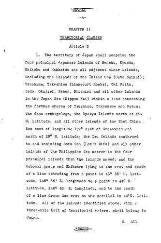
U.S. Draft made on December 29, 1949

Article 3

1.The Territory of Japan shall comprise the four principal Japanese islands of Honshu, Kyushu, Shikoku and Hokkaido and all adjacent minor islands, including the islands of the Inland sea(seto Naikai); Tsushima,Takeshima (Liancourt Rocks), Oki retto, Sado, Okujiri, Rebun, Riishiri and all other islands in the Japan Sea (Nippon Kai) within a line connecting the farther shores of Tsushima, Takeshima and Rebun; the Goto archipelago, the Ryukyu Islands north of 29° N. Latitude, and all other islanls of the East China Sea east of longtude 127° east of Greenwich and north of 29°N. Latitude; the Izu Islands southward to end including Sofu Gan (lot's Wife) and all other islands of the Philippine Sea nearer to the four principal islands than the islands named; and the Habomai group and Shikotan lying to the east and south of a line extending from a point in 43°35' N.Latitude, 145°35' E. logitude to a point in 44°N. latitude, 146°30' E. longitude, and to the south of a line drawn due east on the parsllel in 44° N. Latitude. All of the islands identified above, with a three-mile belt of territorial waters, shall belong to Japan.

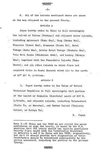
2. All of the islands mentioned above are shown on the map attached to the present Treaty. 

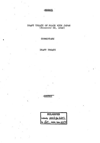
1949 December 29th; 6th Amendment of the Treaty Draft1949 December 29th; 6th Amendment of the Treaty Draft_DoSDraft49.12.29p41949 December 29th; 6th Amendment of the Treaty Draft_DoSDraft49.12.29p5
So it is quite natural that this Prof's "newly discovered" map, attached to the Draft, depicted Liancourt Rocks within Korean territory since that is what the draft on Nov. 2, 1949 said. The point is, this draft, text and map, were amended and replaced by next draft made on 29th December, 1949. Although the map attached to the 29th Dec. 1949 draft is yet to be found, Prof. Jung Byung-joon's claim "the November 1949 map depicting Dokdo as belonging to Korea was the final version" is not true. The map is not the "final version" nor it "confirm" Korean sovereignty since it was already replaced with next draft. It’s pointless to intimidate Japan not to claim territorial sovereignty over Takeshima with this map.

In fact, Mr. Tsukamoto Takashi from the Japan’s National Diet Library had already wrote about this drafting process of Peace Treaty with Japan in his article written in 1994. He’s already introduced the Article 6, which deals with territorial issue, of this draft of Peace Treaty made on Nov. 2, 1949 and the article clearly stated that it has attached map.

The drafting process is well-written in English by Shimane’s Web Takeshima Research Center as below.
The principles of international law have great significance
It is an established principle of international law that a peace treaty is the final determination of a country's territory, however. Whereas the Potsdam Declaration of July 26, 1945 stated, “Japanese sovereignty shall be limited to...such minor islands an we determine, ” SCAPIN #677 specified, “ Nothing in this directive shall be construed as an indication of Allied policy relating to the ultimate determination of the minor islands.” The Allies again declined to make a decision in SCAPIN #1033, which stated, “The present authorization is not an expression of Allied policy relative to ultimate determination of national jurisdiction, international boundaries or fishing rights...”
  The peace treaty is therefore the key to the puzzle, but how does it deal with Takeshima? A draft of the peace treaty with Japan formulated in March 1947 defined the extent of Japanese sovereignty, which included the main islands of Honshu, Kyushu, Shikoku, and Hokkaido, as well as such outlying islands as Oki, Sado,and Tsushima. On the other hand, its provisions stated that Japan renounced the rights and title to the islands of Cheju, Komun, Ulleungdo, and Takeshima. This principle remained unchanged until the draft of November 1949.

A Change in the Provisions Concerning Takeshima at the Draft Stage

The situation began to change when the acting Political Advisor in Japan, William J. Sebald, went a note to the U.S. State Department stating, “Recommend reconsideration Liancourt Rocks (Takeshima), Japan's claim to these islands is old and appears valid” As a result, the treaty draft was amended in December 1949 to add Takeshima to the territory held by Japan and remove the island from the Korean territory that it would renounce.


The later American discussions with the British subsequently adhered to this policy, and the joint American and British draft of June 14, 1951, stated that the territory Japan would renounce would be Cheju, Komundo, and Ulleungdo. This clause eventually became Article 2 (a) of the San Francisco Peace Treaty. The treaty was signed on September 8, and all that awaited was its enforcement on April 28, 1952.


In response to this, the South Korean government that had taken office on August 15, 1948, demanded the revision of the Revised American and British Draft Treaty on July 19, 1951, to include both the islands of Dokdo (Takeshima) and Parangdo (a submerged island) as part of its territory. The American government rejected this demand for revision, however, stating,
“Takeshima was...never treated as part of Korea and, since about 1905, has been under the jurisdiction of the Oki Islands Branch Office of Shimane Prefecture of Japan. The island does not appear ever before to have been claimed by Korea.”.
On January 18th 1952, the President of ROK Syngman Rhee (李承晩) suddenly issued a Declaration concerning maritime sovereignty, with which he installed the so-called “Syngman Rhee Line” including Takeshima/Liancourt Rocks in the Korean territory, it was three months before April when the Peace Treaty would be effective.

1952- January: Syngman Rhee Line

Later, on 12th July, 1954, Korean invaded Takeshima with heavily armed forces and refuse to bring the issue to ICJ against Japan’s proposal.

The Choson Ilbo’s strange discovery story continues as follows.

Jung also discovered another U.S. government map, equally putting Dokdo in Korean territory, that was drawn up by a policy planning taskforce of the State Department on Oct. 14, 1947 to define Japanese territory. Until recently it was believed that this map was drawn up in 1949 or 1950.

The map he “discovered” is the map made by Jorge F. Kennan, the director of the Policy Planning Staff(PPS). The documents are included in the FRUS, The Foreign Relations of the United States, a book series published by the Office of the Historian in the United States Department of State. It’s even available online here. Moreover, the PPS documents are sold in the form of microfilms more than 20 years ago. How on the earth he can “discover” the map which is open to the public ages ago?

I strongly recommend Prof. Jung and Choson Ilbo to stop this kind of silly argument and claiming that he “discovered” things which are already known.

The initial information of the Choson Ilbo’s article was informed by matsu and other information concerning to the drafting process of the Peace Treaty were provided by Mr. Tsukamoto.

Mr. Tsukamoto Takashi's article is written in Japanese.
Takashi Tsukamoto, "Heiwajoyaku to Takeshima (sairon)" Reference 1994. 3, pp. 31-56. (塚本 孝「平和条約と竹島(再論)」、『レファレンス』第518号、国立国会図書館調査及び立法考査局、1994年3月、pp.31-56)

The article and related articles in Japanese.
独島:「韓国領」明示1949年の米国の地図を発見 (cache)
独島:鄭秉峻教授「1947年が重要な分岐点」 (cache)
独島:初めて領土標識を立てた「独島学術調査隊」 (cache)

References ;
History of San Francisco Peace Treaty
1946 - SCAPIN 677 - #1
1946 - SCAPIN 1033 - #2
1947 - SCAPIN 1778 - #3
1949 - Willam J. Sebald's telegram - #4
1949 - A letter from W. Walton Butterworth - #5
1949 - December 29th; 6th Amendment of the Treaty Draft - #6
1950 - July - Commentary on Draft Treaty by the Department of State - #6-b
1950 - August - U.S. Draft of the Peace Treaty - #6-c
1950 - October 26th - USA Answers to Questions Submitted by the Australian Government - #7
1951 - April - May: Joint UK and USA Draft - extra(1)
1951 - June 1 - New Zealand's view - extra(2)
1951 - July 9th - Coversation of Yu Chan Yang with John F. Dulles - #8
1951 - July 19th - The 2nd Conversation between Yu Chan Yang and John F. Dulles - #9
1951 - August - Another letter from You Chan Yang - #10
1951 - August 3rd - Memorandum - #11(On re-ceiving Boggs's memo. I asked the Korean desk to find out whether anyone in the Korean Embassy officer had told him they believed Dokdo was near Ullengdo, or Takeshima Rock, and suspected that Parangdo was too.)
1951 - August - Rusk's Letter - #12
1951 - September 9th - San Francisco Peace Treaty - #13
Korea's Illegal Land Grab from Japan
1952- January: Syngman Rhee Line
After the Installation of Syngman Rhee Line - American documents
1952 - November - Confidential Security Information of USA - #1 ("It appears that the Department has taken the position that these rocks belong to Japan and has so informed the Korean Ambassador in Washington." )
1952 - December - Confidential Security Information of USA - #2( "I much appreciate your letter of November 14 in regard to the status of the Dokdo Island (Liancourt Rocks). The information you gave us had never been previously available to the Embassy. We had never heard of Deen Rusk’s letter to the Korean Ambassador in which the Department took a definite stand on this question.")
1953 July: Confidential Security Information of USA - #3( The United States Government's understanding of the territorial status of this island was stated in assistant Secretary dated August 10,1951.")
1953 - November - Secret Security Information of USA - #4 ("The Liancourt Rocks case appears to have aspects in common with that of Shikotan Island" "Remind the ROK of our previous statement of view (the Rusk letter)")
1953 - December - SECRET SECURITY INFORMATION by Dulles - #5

9.7.10

2010 - July 7th - South Korean terrorist attacked Japanese Envoy

Korean government should stop brainwashing its own people and start educating them how to “debate” logically without resorting to violent act of terrorism immediately.

“I’m going to kill you, you **** !!”

On 7th July, 2010, "The our yard Dokdo keepers”(우리마당 독도지킴이) representative Kim Ki-joong assaulted Japanese Envoy to South Korea Shigeie Toshinori(重家俊範) with a 10-centimeter's rock twice in Korea Press Center in Seoul. Mr.Shigeie avoided the attack, but Mayumi Horie, his translator, was hit in the hand and taken to a nearby hospital.

I saw it on Japanese News, and it was ugly and appalling. But it was rare opportunity for Japanese viewers to see Japanese major TV news clearly reiterate Japanese government’s stance on Takeshima. Japanese media ignores Takeshima unless Korean do something stupid.

From the Ministry of Foreign Affairs of Japan’s site.
Japan's Inalterable Position on the Sovereignty of Takeshima
  1. In the light of historical facts and based upon international law, it is apparent that Takeshima is an inherent part of the territory of Japan.
  2. The occupation of Takeshima by the Republic of Korea is an illegal occupation undertaken on absolutely no basis in international law. Any measures taken with regard to Takeshima by the Republic of Korea based on such an illegal occupation have no legal justification.

(Note: The Republic of Korea has yet to demonstrate a clear basis for its claims that, prior to Japan's effective control over Takeshima and establishment of sovereignty, the Republic of Korea had previously demonstrated effective control over Takeshima.)

More on Japanese FNN News on 7th July and on 8th July.

According to Donga News, while police investigation, he cried out that he wanted to be a Ahn Jung-geun(安重根), a terrorist who shot and killed Ito Hirobumi(伊藤博文), but he failed.

“안중근처럼 그 ○○ 죽여 버리고 역사에 남고 싶었는데 못했다”

According to Joong-An Daily, a South Korean foreign ministry spokesman apologized to Japan.

“Minister Yu made a phone call to Ambassador Shigeie to express his regrets,” Foreign Ministry spokesman Kim Young-sun said in a briefing yesterday. “What happened last night was completely unacceptable and we are feeling very regretful about it.”

IMO, it is Korean government herself who are agitating its own people to act on unacceptably by its own barbarised acts of invading Japanese island Takeshima without any documented evidence which support their claim that Dokdo/Takeshima have been Korean territory since 512 A.D. !?

More on a Korean News.

13.6.10

2010 - Dokdo Institute of Yeungnam University admits Usando in Choson's official map of Ulleungdo(鬱陵島圖形) in 1711 is Jukdo, not Dokdo/Takeshima.

Dokdo Institute of Yeungnam University admits Usando in Choson's official map of Ulleungdo(鬱陵島圖形) in 1711 is Jukdo, not Dokdo/Takeshima.

Dokdo Institute of Yeungnam University(嶺南大学独島研究所) practically admitted Usando, which South Korean government has been claiming as Takeshima/Liancourt Rocks/Dokdo's old name since 1953, described in the detailed map of Ulleungdo "鬱陵島圖形", made and submitted to the King by official inspector Bak Seok-chang (朴錫昌) to Ulleungdo in 1711, was not Dokdo, but Ulleungdo's biggest neighbouring island Jukdo(竹島), which is 2-4km east to Ulleungdo in recent book. Prof. Kim Hwa-Kyung(金和経), the head of the Institute, wrote as below in their recent published book "Study for the establishment of Sovereignty over Dokdo"(독도 영유권확립을 위한 연구) (2010).

On the east side, to the the lower in this map by the way, there is writing "(there is) long groves of bamboos alongside the coast, so-called Usando"(海長竹田 所謂于山島). Seoul Nat'l University's Kyujanggak Institute of Korean Studies, that stores the map, explains that "the island which is written Usando on it seems to be Dokdo". However, it is clear that this explanation doesn't severely examine the map material. Because, it is natural to consider the island to be Jukdo(竹島) of today if there was bamboo grove long in the coast on the island. In fact, Oh Sang-Hak(呉尚學) wrote "the island is presumed to be Jukdo, which locates 4km from main island of Ulleungdo, considering from the location and the annotation "(there is) long fields of bamboos on the coast, so-called Usando. since Jukdo is the only island among the neibouring island of Ulleungdo on which the bamboo grove can long grow along the coast." (p25)
------------------------------------------------------------------
ところでこの地図には下段にあたる東側に、「海長竹田 所謂于山島」すなわち「海岸に長く竹薮がある いわゆる于山島」という書き込みがある。これを所蔵しているソウル大学奎章閣の解説には「ここで于山島と記入してある島が、まさに独島を指称しているようである」と書かれている。しかし、この解説は地図資料を厳格に検討していないことは明らかだ。なぜならば、海岸に長く竹薮があったと言えば、その島は独島ではなく、今日の竹島(竹嶼)を指したと見ることは当然であるからだ。 実際、呉尚學は「この島は、描かれた位置と『海岸に長く竹田がある』という註記から見て、鬱陵島本島から4Kmほど離れた竹島(竹嶼)と推定される。鬱陵島の付属島嶼として竹田が長く形成されることができる島は、竹島(竹嶼)以外にはないためだ」といい、この島を竹島(竹嶼)と見た。

As Prof. Kim quoted in the article, Prof. Oh Sang-Hak(呉尚學), whose expertise is Historical Geography had already admitted this in his article "The Change in Perception of Ulleungdo and Dokdo Represented in Maps of the Joseon Dynasty"(2006)". It was slightly before Gerry's pointed out that Usando in 1711 map is Jukdo since "Haejangjuk"(海長竹) is a kind of bamboo that cannot grow on Takeshima in the Japanese Newspaper San-in Shimpo on February 2007.

One of the maps, which is undated, shows a small island east of Ulleungdo with the following written on it: “The so-called Usando, fields of Haejangjuk.” It is pointed out that Haejangjuk is a kind of bamboo that cannot grow on Takeshima, which is essentially just a cluster of rocks where bamboo does not grow.

Prof. Kim and Oh are not the only one who admitted Usando in the maps is Jukdo. In fact, Dokdo Museum Head also Admits Maps Show “Jukdo, not Dokdo” on March 20th, 2007.

Dokdo Museum Director Lee Seung-jin said, “After confirming the three old maps, it is obvious to anyone that they showed Jukdo, not Dokdo; and even in our country’s academic circles, it is judged to be Jukdo. By not showing the complete map and by showing only an enlarged section, they are trying to cover up their forced claims.”

Korea’s Northeast Asia History Foundation rebutted to Gerry as well, while their argument was quite misdirected.

The part that says, “The so-called Usando” is just written on the outline of an island, similar to four islands to the south, which is different from islets like Samseon Rocks and Elephant Rock on the north side of the island. Actually, there are no islands to the south of Ulleungdo. It is assumed that the map was not made from an actual survey, but was made based on hearsay. Concerning “haejangjukjeon, the so-called Usando,” it is believed that the inspector did not conduct a “concrete” investigation, but just followed the coastline and drew Jukdo (Bamboo Island), with its tall bamboo, and Usando (Dokdo), which was determined clearly at that time by the activities of An Yong-bok.

If their explanation is true, then the map is rather the concrete evidence that official inspector of Joseon Dynasty who actually conducted the on the spot survey identified the shapes and location of Japan's Matsushima= U(J)asando by Ahn Yong-bok according to what people say and clearly recorded that Usando is not today's Takeshima/Dokdo, but Jukdo. Because Ahn Yong-bok testified that it took less than few hours for him to move from Ulleundo to Jasando, at dawn on 15th of May. Besides, Ahn said he "pulled the boat into Usando(拕舟入子山島)". It is natural for the inspector who went to Ulleugndo and saw Jukdo to identify it as so-called Usando. Whatever the island Ahn had witnessed was, it is apparent that both Joseon Dynasty and scholars out of office
considered the island was Jukdo. Scholars out of office including Chŏng Sang-gi (鄭尚驥) who made "東国地図" and others who made the copies and Prof. Oh presume Chong put Usando east to Ulleungdo, namely the "exact" place of today's Dokdo according to Ahn's story, without any concrete evidence. But it is quite obvious as Chong and its follower's Usando is placed right next to Ulleungdo and it never go beyond the scope of the place of Jukdo, the Ulleungdo's neighbouring island of 4km east, which exactly matched with Ahn's testimony again.

And finally, Prof. SONG Byeong-Gi(宋 炳基) seems to be cornered and also gave up cheating people, and finally admitted that Usando in this 1711 official map is not Dokdo, but Jukdo in his revised book "Ulleungdo and Dokdo"(재정판 울릉도와 독도)(2007) . (Japanese translation by Mr. 朴 炳渉, a.k.a. Half-moon.)

By the way,
Korean academics mistranslated haejangjuk(海長竹田). "海長竹田" is not "long groves of bamboos alongside the coast" nor just a “grove of tall bamboo along the coastline", but is groves of "海長竹", a unique kind of bamboo. Japanese called it as 女竹. Japanese "Ministry of Foreign Affairs, Department of Trade, Document Section: Trade Documents" (外務省通商局編纂 通商彙纂) recorded that 女竹 grow on Jukdo in 1902.

The inspector's map of Ulleungdo is Joseon's official maps and are the basis of other maps made thereafter.

The map is one of the 6 Ulleungdo maps extant made by official investigators to Ulleungdo. The official maps of Ulleungdo as a result of regular inspection are extremely important in the history of Korea's geography since this is produced by officials and were positively used to produce the county prefecture map(郡県地図) of a nationwide thereafter such as "海東地図", "廣輿図". "朝鮮地図". And it is succeeded to the large reduced scale complete map produced in the 19th century thereafter.

Actually,
Seoul Nat'l University's Kyujanggak Institute of Korean Studies, who even strangely write Usando in this map is definately Dokdo, admits Usandos in some of the Ulleungdo maps "may be" Jukdo, not Dokdo on its website.

지승(地乘)〈奎 15423〉
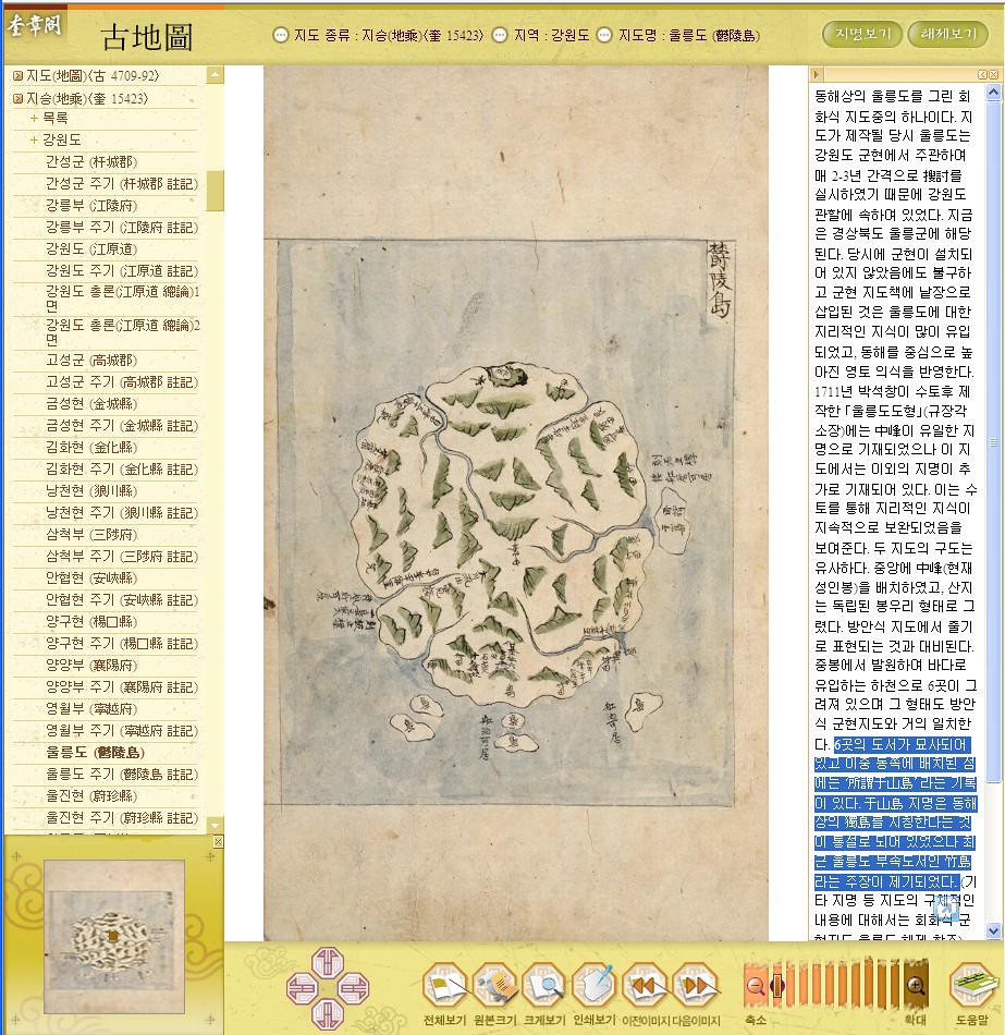
Among 6 islets depicted, there is the writing "
so-called Usando" on the islet located east side. The name "Usando" is normally considered to be the Dokdo, which locates in East Sea, however, recently, the claim that it is Ulleungdo's neighbouring island Jukdo was instituted. (Kim Ki-Hyuk)
---------------------------------------
6곳의 도서가 묘사되어 있고 이중 동쪽에 배치된 섬에는 ‘所謂于山島’라는 기록이 있다. 于山島 지명은 동해상의 獨島를 지칭한다는 것이 통설로 되어 있었으나 최근 울릉도 부속도서인 竹島라는 주장이 제기되었다. ...
(김기혁)
---------------------------------------
6ヶ所の島嶼が描写されていて、この中で東側に配置された島には‘所謂于山島’という記録がある。 于山島という地名は東海上の独島を指し示すということが通説になっていたが、最近、鬱陵島附属島嶼の竹島(訳注 : 日本名竹嶼、以下同じ)という主張が提起された。) (キム・キヒョク)

조선지도(朝鮮地圖)
(奎16030) (1750-1768)
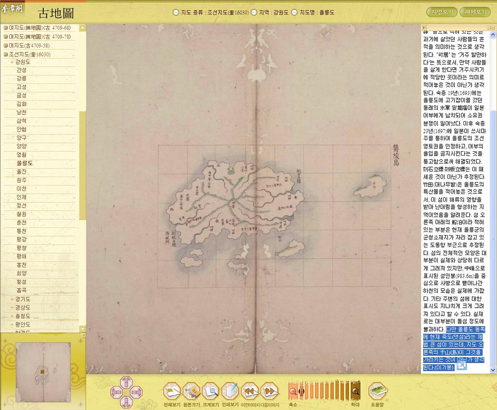
However, there is fairly large island Jukdo on the east side of Ulleungdo, and Usan(do) depicted right side of the map is considered to be it(Jukdo). (Lee Ki-bong)
---------------------------------------
다만 울릉도 동쪽에 현재 죽도(댓섬)라는 제법 큰 섬이 있는데, 지도 오른쪽의 于山(島)이 그것을 가리키는 것이 아닌가 생각된다.(이기봉)
---------------------------------------
ただし鬱陵島東側に現在の竹島(テ(デ)ッソム/日本名竹嶼)という結構大きい島があるが、地図の右側の于山(島)がそれを示すのではないか考えられる。(イ・ギボン)

여지도(輿地圖)
〈古 4709-68〉
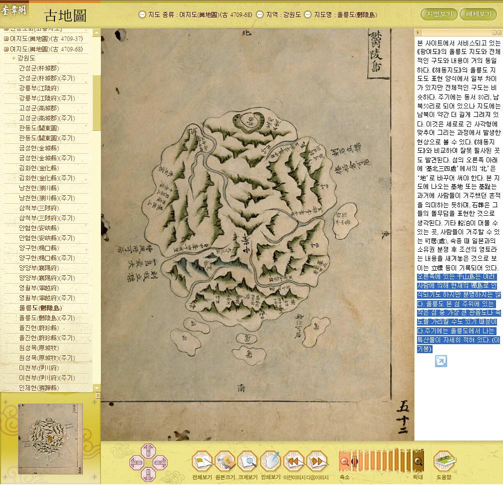
A variety people consider Usando on the right side of the map is today's Dokdo, but it is not clear. Since it is possible that it indicates the biggest island of Kwannundo or Jukdo among the tiny islates around main island of Ulleungdo. (Lee Ki-bong)
---------------------------------------
오른쪽에 있는 于山島는 여러 사람에 의해 현재의 獨島로 인식되기도 하지만 분명하지는 않다. 울릉도 본 섬 주위에 있는 작은 섬 중 가장 큰 관음도나 죽도를 가리킬 수도 있기 때문이다....(이기봉) 
---------------------------------------
右側にある于山島は色々な人によって現在の独島と認識されるけれども明らかではない。 鬱陵島本島の周囲にある小さい島の中で最も大きい観音島や竹島(チュクト/日本名竹嶼)を指している可能性もあるためだ。... (イ・ギボン)

지승(地乘)〈奎 15423〉조선지도(奎16030) 朝鮮地圖(1750-1768)여지도(輿地圖)〈古 4709-68〉

Korea's claim that Usando in Korea's old maps are today's Takeshima/Liancourt Rocks/Dokdo is fake.

As have been shown, Korean scholars gradually started to admit Usando in
"The map of Ulleungdo" (鬱陵島圖形)(1711) and other Korea's old maps, especially after 18c are Jukdo, not Dokdo, while Korean government still keep claiming Usando had been Dokdo since 512 in its propaganda and reject Japan's proposal to bring the issue to the International Court of Justice.

I honestly hope Korean government, academics, media & journalists, singer Kim someone, VANKers, netizens and some permanent residents in Japan accept this eternal fact that Korean had never considered Takeshima/Liancourt Rocks was their territory before 1905. Usando after 1711 official map of Ulleungdo were Jukdo and they should stop absurd claim such as Usando is Takeshima's old names from 512.

References ;
Interview with Sankei Shimbun Reporter on Dokdo/Takeshima
: Sunday, April 22nd, 2007

Dokdo Museum Head Admits Maps Show “Jukdo, not Dokdo” : Tuesday, March 20th, 2007

New Article on Usando & “Haejang” Bamboo : Tuesday, March 13th, 2007

The other article about Gerry in the San-In Chuo Shinpou : Tuesday, February 27th, 2007

Korean History Group Responds to Japanese Article on Usando : Saturday, February 24th, 2007

New Takeshima (Dokdo) Article in Japanese Newspaper : Wednesday, February 21st, 2007

Korean Scholar Says "Usando" Was Ulleungdo's "Jukdo"

Ulleungdo's Neighboring Island of Jukdo (죽도 - 竹島)

1696 - Ahn's so-called Matsushima/Usando was Jukdo, afterall. 
(元禄九丙子年朝鮮舟着岸一巻之覚書 肅宗実録 30卷, 22年 戊寅)