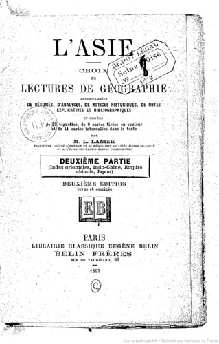
This French book of Geography "L'Asie, choix de lectures de géographie-Deuxième Partie" was written by Lanier, Lucien (1848-1908) in 1893. (There are more editions as 1892, 1908 on Google books.)
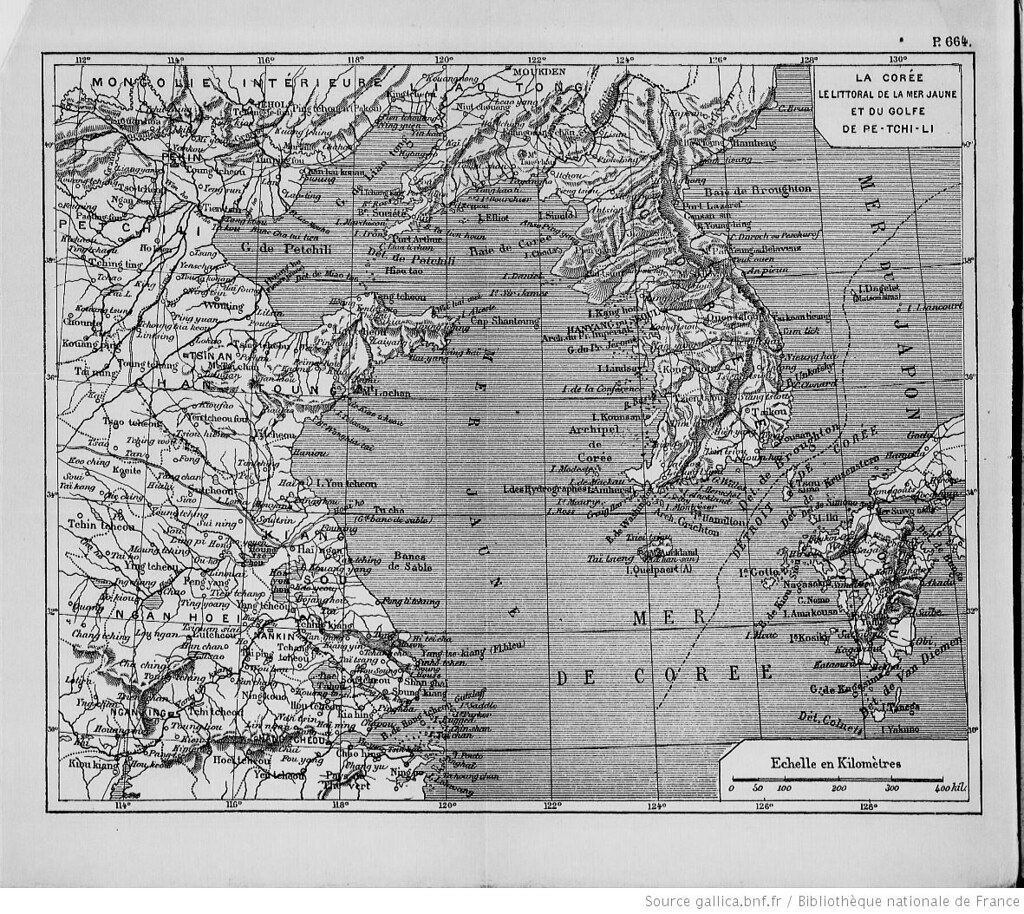
The description of the Korean geography only describes "Korean peninsula", but the description of the "islets", as shown below, included Dagelet/Ulleungdo/Matsushima, but not "Liancourt Rocks" which was found and named by French in 1949. However, the map attached to the book clearly excluded Liancourt Rocks from Korean territory. Apparently, the author Lanier considered Liancourt Rocks is not Korean territory.
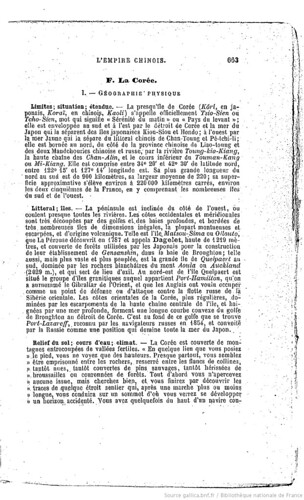
La Corée.
I. Geographie Physique
Limites; situation; étendue. -La presqu'île de Corée...Elle est comprise entre 34°20′et 42°30′de latitude nord, entre 122°15′et 127°14′longitude est. ...
( 127°14’ E+ 2°20’(Eastern longitude of Paris) = 129°34’E (Greenwich Meridian))
Littoral; îles
...Telle est L'île. Matsou-Sima ou Ollouto, que La Perouse découvrit en 1787 et appela Dagelet, haute de 1219 mètres, et couverte de forèts utilisées par les Japonais pour la construction de leur établissment de Gensanshin, dans la baies Broughton; telle aussi, ...


The Volume I of the book is available on Google Books. "L'Asie: Choix de lectures de geographie, accompagnées de résumés, ..."
References;
1846 - French map of Korea (Coree)
1865 c - French map of Korea ( Corée)
1874 - "Histoire de L'Eglise de Corée" by Claude Charles Dallet
1874 - "Histoire de L'Eglise de Corée" by Claude Charles Dallet
1890 - Carte de Coree
1894 - French map of Korea and Japan (Is. Liancourt ou Hornet (Jap))
1894 - Carte De La Coree from "Le Petit Journal"
1894 - Jpn Gazetteer: Usando "in the vicinity of Ulleungdo" (于山島:蔚陵島ノ近傍) (三橋僊史著『朝鮮地名案内』)
1894 - French map of Korea and Japan (Is. Liancourt ou Hornet (Jap))
1894 - Carte De La Coree from "Le Petit Journal"
1894 - Jpn Gazetteer: Usando "in the vicinity of Ulleungdo" (于山島:蔚陵島ノ近傍) (三橋僊史著『朝鮮地名案内』)
Sorry for not-organized post. Not easy for grabbing direct url and upload the images.
ReplyDeleteブロガー不調のためか、画像をうまくデザイン配置が出来ませんでしたが、記録代わりに投稿しました。
Bibliothèque nationale de France has a lots of maps and books available on the net. Put the words you want to research and go to "Gallica" to see them.
ReplyDeletehttp://www.bnf.fr/fr/outils/lr.resultats_recherche_simple.html?query=carte+coree&x=0&y=0
Kaneganese as usual your can be found to be incorrect.
ReplyDeleteIf you look closely at the attached map the boundary drawn on it excluded Matsushima/Dagelet (today’s Ulleungdo) from Korea. We know this was not the case. Ulleungdo is indisputably Korean territory from the 5th Century. For this reason, these records have little relevance in historical research regarding territorial ownership of Dokdo. You can see the attached map doesn’t match the documents.
Secondly you should consider this fact. In the 19th Century were uninhabited rocks used as a basepoint for drawing international boundaries in the open sea? I don’t think at this time the concept of Marine Boundaries was the same as the today. For example Japan possessed many outlying islands distant from the Japanese mainland however I don’t think they claimed huge tracts of surrounding waters as international boundaries during the 19th Century.
Please be honest when you post Kaneganese.
www.dokdo-takeshima.com
I think this Post is continued from the two comments which are recently put by GTOMR and Kaneganese.
ReplyDeletehttp://dokdo-or-takeshima.blogspot.com/2008/07/1894-jpn-gazetteer-usando-in-vicinity.html
French knew Liancourt Rocks for a long time before, and they knew it was not Ou-san in these maps.
BTW, does someone know French maps that show Liancourt Rocks?
and narrative of the whale ship which found the Rocks in 1849?
or official French documents that describes about the finding of Liancourt Rocks?
Kaneganese,
ReplyDeleteDoesn’t this map show the Dagelet(Ulleungdo)also belongs to Japan?
matsu-san
ReplyDeleteYes. I guess it is because this map labeled only I. Dagelet and Matsushima. And Liancourt Rocks are also included in Japanese territory. But the geographical description in the book include Ulleungdo as Korean territory.
60-70% of western maps around this period depict Daglet/Matsushima, along with Liancourt Rocks, as Japan's. But Japanese Meiji government didn't incorporated Ulleungdo after all since they knew it is Korean.
こちらの投稿がフランス図書館との話のことで、それとは全く関係がありませんが、共産中国作成の北朝鮮圖を集めてみました。
ReplyDeleteBelow is the DPRK map made by Chinese Commie.
1950.朝鮮民主主義人民共和国新地圖 中国史地学社刘思源、董石声编制,金擎宇校订
http://www16.tok2.com/home/otakeshimaoxdokdox/China%20Map/1950.NewDPRKmapbyPRC.jpg
1950.07.28 最新朝鲜形势地图(1950年7月28日初版) 上海 百新书店 新文化书社 锦章书局 联合出 编绘者 杨景雄
http://www16.tok2.com/home/otakeshimaoxdokdox/China%20Map/1950.07.28.NEWESTDPRKMap.jpg
1950.09.朝鲜地图 中央人民政府人民革命軍事委員会作戦部測絵局 新華書店
http://www16.tok2.com/home/otakeshimaoxdokdox/China%20Map/1950.09.DPRKMapbyPRC.jpg
1951.1951.朝鲜民主主义人民共和国新地图.
http://www16.tok2.com/home/otakeshimaoxdokdox/China%20Map/1951.NewDPRKmap.jpg
1951.朝鲜民主主义人民共和国
http://www16.tok2.com/home/otakeshimaoxdokdox/China%20Map/1951.DPRKmap.jpg
1953..朝鲜地形大挂图 地図出版社
http://www16.tok2.com/home/otakeshimaoxdokdox/China%20Map/1953.NewDPRKmap%20by%20PRC2.jpg
うわっ、これまた大発見ですね。
ReplyDelete1949年の共産党政権の成立以降ですから、すべて中国としての「国家的」な見解をあらわす地図ということになります。
そのすべての地図が、朝鮮の領土としての「独島」を認めていない。
これによって、「1946年、SCAPIN677によって、独島は再び祖国のふところに抱かれた」という韓国側の主張は、まったく国際的に通用しない「たわごと」であることがわかります。
また1953年の地図に至っても同様である(独島がない)ということは、
1951年のサンフランシスコ条約に中国は参加していないわけですが、その結果として竹島が日本側に残されたことを、中国も認めている、ということではないでしょうか。
こうなってくると、この当時の「ソ連」の地図も見たいもんですね。
それから・・・。「日本地図」はないんでしょうか?
「竹島」がどうなっているかも、もちろん気になりますが、
この段階では、中国は「尖閣列島」を「琉球」に含めていたはずで(1953年の『人民日報』)、その表示も気になります。
Matsu様、
ReplyDelete>それから・・・。「日本地図」はないんでしょうか?
それが、別件も兼ねてこのあたりの日本地図をオークションサイトで探しているのですが、1950-69年あたりの地図が一向に出てこないんです…
how can they decide possesion of Dokdo? as u know japan ruled korea 60 years ago, and they would not get back our island. they didnt think dokdo can make big deal at their trade, they are so selfish.
ReplyDeletetruth is gunna be revealed. and truth is gunna be win. do not distort our history. please
"1950-69年あたりの地図が一向に出てこないんです…"
ReplyDelete「尖閣諸島は中国固有の領土」なる主張と矛盾する内容が含まれているんでしょうね。
1971年12月の中華人民共和国の領有宣言は日本への帰属が確定している尖閣諸島に対するもので、強引な横車のようなもの。なぜ日本政府はこの点を指摘しないのか……。
2010.11.8