A study of the territorial dispute between Japan and Korea over Liancourt Rocks, a small cluster of barren, rocky islets in the Sea of Japan that Japanese call Takeshima and Koreans call Dokdo.
The new blog you linked have lots of Korean maps we have never seen before. I asked the owner if I could introduce them in our blog, and he answered that he is honoured. Maybe, we can list the site to pro-Japanese site?
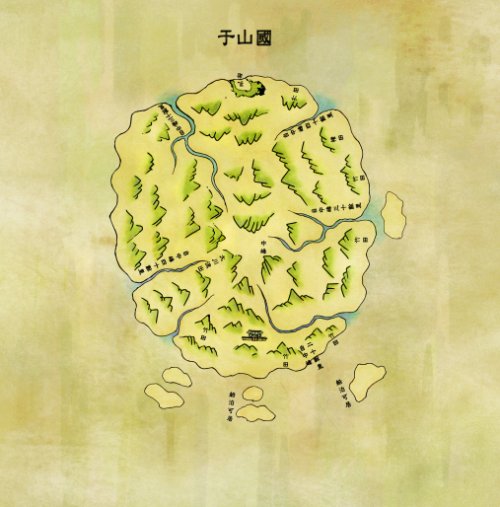
Below is the original Korean article of this map. I read it in Yabutarou's comment at Yahoo! BBS.
One of the silliest claims from Korea. I believe there are lots of decent scholars who oppose againt his imagination even in Korea. The map he "Koreate"d does not reflect the recognition of Ulleungdo in Shilla, but 1711' inspector's map.
It can assmed that this "reproduced" Ulleungdo detail map was after 1694 or 1711. Before Ulluengdo inspection late of 17century, they use "歩”instead of "里”
IN this map, there are five distance from 中峯。
Checking many Ulluengdo detail maps, like circle shape or pentagram shape, rectangurar shapes, there has two type design about distance.
One is, early stage design which referenced from 1711map with five distance from 中峯, and late of 18century the distance discription is only four mostly.
I don't understand why Korean scholars fabricated this map... it only says that Unsan-guk means Ulleungdo, not Liancourt Rocks.
Even if this fabricated map was from the 512 AD, it is not a proof of ownership of Liancourt Rocks. Or do they want to make it certain that Ulleungdo belonged to Korea?
Thanks for the link to the article, but the article does not give a date for the map or say where it came from, which seems like a big mistake on the part of the reporter.
Anyway, the article says that the man being interviewed in the article claims that of the five islands off the southern shore of Ulleungdo, "Dokdo" is the one on the far right. However, he gives no evidence or explanation for making that claim. In other words, it is just another wild claim.
Can anyone read what is written next to the islands off Ulleungdo's southern shore?
That suggests that those islands may have been rocks near coves where boats could land. Also, other Korean maps have drawn ports as islands, for some reason.
Of course, the mapmaker may not have just written 船舶可居 there because he did not know where else to write it.
Gerry,
ReplyDeleteThe new blog you linked have lots of Korean maps we have never seen before. I asked the owner if I could introduce them in our blog, and he answered that he is honoured. Maybe, we can list the site to pro-Japanese site?
Below is the original Korean article of this map. I read it in Yabutarou's comment at Yahoo! BBS.
http://www.segye.com/Articles/NEWS/SOCIETY/Article.asp?aid=20080717003021&subctg1=00&subctg2=00
One of the silliest claims from Korea. I believe there are lots of decent scholars who oppose againt his imagination even in Korea. The map he "Koreate"d does not reflect the recognition of Ulleungdo in Shilla, but 1711' inspector's map.
It can assmed that this "reproduced" Ulleungdo detail map was after 1694 or 1711.
ReplyDeleteBefore Ulluengdo inspection late of 17century, they use "歩”instead of "里”
IN this map, there are five distance from 中峯。
Checking many Ulluengdo detail maps, like circle shape or pentagram shape, rectangurar shapes, there has two type design about distance.
One is, early stage design which referenced from 1711map with five distance from 中峯, and late of 18century the distance discription is only four mostly.
I don't understand why Korean scholars fabricated this map... it only says that Unsan-guk means Ulleungdo, not Liancourt Rocks.
ReplyDeleteEven if this fabricated map was from the 512 AD, it is not a proof of ownership of Liancourt Rocks. Or do they want to make it certain that Ulleungdo belonged to Korea?
Kaneganese,
ReplyDeleteThanks for the link to the article, but the article does not give a date for the map or say where it came from, which seems like a big mistake on the part of the reporter.
Anyway, the article says that the man being interviewed in the article claims that of the five islands off the southern shore of Ulleungdo, "Dokdo" is the one on the far right. However, he gives no evidence or explanation for making that claim. In other words, it is just another wild claim.
Can anyone read what is written next to the islands off Ulleungdo's southern shore?
Gerry,
ReplyDeleteIt's "船舶可居", both of them.
Thank you, Kaneganese.
ReplyDeleteThat suggests that those islands may have been rocks near coves where boats could land. Also, other Korean maps have drawn ports as islands, for some reason.
Of course, the mapmaker may not have just written 船舶可居 there because he did not know where else to write it.