Murakawa and Ohya clan were hunting sealions and harvesting abalones on the island on the way from Ulleungdo with the official licence from Tokugawa Shogunate. The abalones were presented to Shogunate every year, and the audience to Tokugawa Shogun was specially permitted exceptionally as a civilian tradesman. Murakawa clan, especially, was the one who went to today's Takeshima intensively as a sole destination, but later, Ohya clan did joined the plan.


The topographical map of Takeshima compiled by Geographical Survey Institute (GSI), 2008
Below is the translation of "The analysis of Japanese illustrative maps " by Funasugi Rikinobu (Shimane University)
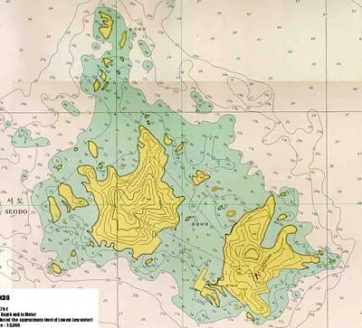
"Illustrative Map of Matsushima (松嶋絵図)" (photograph) owned by San-in history Museum, Yonago(米子市立山陰歴史館)This is from the Final report by Takeshima Research Center, 2007 (竹島研究会最終報告書 2007)
The map illustrates Matsushima(松嶋 : today's Takeshima/Liancourt Rocks/Dokdo) alone precisely. This is the first time that the existence of an old map which depicts Matsushima alone were confirmed. It was presented at the exhibition in the Museum in 1987 and was photographed then. It's considered to be Murakawa clan's(村川家) property.
The Matsushima was depicted more precisely than the one in "Takeshima Illustrative Map by Kotani Ihei"(1696 c.a.). On the upper-right of the map, it recorded the circumference of Matsushima and the distance from Oki islands and Takeshima(Ulleundo) as follows. "Matsushima Illustrative Map, whole circumference of the island is within 1 ri, and the voyage from Oki country to Matsushima is almost 100 ris, and the distance from Matsushima to Takeshima is 30 ri.". This means the distance from Oki islands to Matsushima is about 185km, to Takshima is 56 km. According Mr. Sugihara, the illustrative maps which drew Matsushima and Takeshima in mid-Edo era recorded distance from Oki islands to Matsushima as 60 ri (111km) or 80 ri (148), thus it is considered to be made in mid 17 century when Murakawa received the licence for the development for Matsushima.
There is a note "approx. 218m strait(瀬戸長さ弐町)" between eastern island and western island. Three tiny shores are recorded on western island. Two of them are written "tiny shore 22m(小濱拾弐)", and the rest is written "tiny shore about 21m(小濱拾壱間)". The inlets of eastern and western islands are recorded as well. Addition to that, the rocks around Matsushima are also drawn. When you compare it with the sea chart (1:5000) of Dokdo published by Korean National Sea Survey Institute in 2001, inlets and rocks around the islands are almost identical.
According to Mr. Sugihara(杉原副座長),a vice- chairperson of research group, Murakawa was the one who had been hunting sealions and harvesting abalones actively on the shore of Matsushima. And the inlets and rocks were important places for harvesting those marine products as sealions and abalones.
There had been no other precise illustrative maps such as this so far. Besides, there were absolutely no old Korean maps which illustrates Matsushima , and in detail as such. Therefore, this is one of the important historical resources to prove Japan had engaged in economical activity on Matsushima(松嶋 : today's Takeshima/Liancourt Rocks/Dokdo).
"Takeshima in Illustrative Maps and Maps Vol.II " (絵図・地図からみる竹島(II))
3. The analysis of Japanese illustrative maps ( 3.日本側作製の絵図の分析) by Associate Professor Funasugi Rikinobu (Shimane University) (舩杉力修 島根大学法文学部・歴史地理学)
Courtesy of Web Takeshima Research Center.
The Murakawas were from Yonago and they were the only ones given rights to (illegally) voyage to Korea's Ulleungdo and Dokdo. As the below documents below show, although the Japanese were given "permission" to voyage to these islands not only were they not considered to be Japanese, they were percieved to be Korean .However, in 1695 Japan declared that both Matsushima (Dokdo) and Takeshima (Ulleungdo) were not part of Japan.
ReplyDeletePlease read below.
MatsushimaNotPartOfJapan
In fact in 1836 the Takeshima Incident once again showed both Matsushima and Takeshima were actually part of Korea.
MatsushimaKoreanLand
You forgot to post these maps.
JapanNoDokdo1
JapanNoDokdo2
JapanNoDokdo3
JapanNoDokdo4
JapanNoDokdo5
JapanNoDokdo6
Japanese maps either consistently excluded Dokdo or considered the islets as Korean.
Kaneganese,
ReplyDeleteThanks for the article. This is a fact that Japanese fishermen actually went to Liancourt Rocks (Takeshima/Dokdo) already in the 17th century, while there is no such a precise map in Korea.
If you visited Liancourt Rocks, most impressive character of the island should be that it consisted of two islands. But there is no such map in Korea, which means Korean people haven't visited the place in those days. Ulleungdo was their eastern limit.
Steve,
ReplyDeleteJapanese fishermen knew the place well, while Korean people didn't know the place.
It is simple as that, Steve.
If you want to refute, bring a map of Liancourt Rocks which was drawn by Korean people in the 17th century. You don't need to bring any other things, Steve.
またいきなりすいません。
ReplyDeleteflashをつくってみました。
しかしながら私のサイトのページ内で表示させる方法がわかりません。。
どうすればよいのでしょうか。。。
http://outdoor.geocities.jp/yabutarou01/a.swf
http://outdoor.geocities.jp/yabutarou01/usann.swf
藪太郎の研究室
http://outdoor.geocities.jp/yabutarou01/
あと私のサイトが独島本部のサイトで紹介されていました。
http://dokdocenter.org/dokdo_news/index.cgi?action=detail&number=7971&thread=18r04r04
to.. pacifist
ReplyDeleteI must say you are rather totally misunderstanding the nature of dokdo/takeshima conflict. It is a FALSE claim that Koreans lack a detailed map of dokdo/takeshima.
If one is able to argue into that depth, I suppose I tell you to reconsider Korean perspective.
Yeah. Study more. You.
Anonymous,
ReplyDeleteThank you for your comment.
But your opinion seems to be not right, because Korea has no precise map of the island.
And there is no document at all in Korea.
Please bring your evidence to confirm your opinion, yours is just an imagination.
pacifist
ReplyDeleteHere's the map you want
http://dokdoup.cafe24.com/img/history/old/korea/old_korea03.jpg
This map shows that early 16th century Chosun knew the place you were talking about.
Here's another map of Japan
http://dokdoup.cafe24.com/img/history/old/japan/old_japan040.jpg
This map was made by Hayashi Shigei
in 1785, he was one of the geographer in Japan.
http://dokdoup.cafe24.com/img/history/old/korea/old_korea03.jpg
ReplyDeletehttp://dokdoup.cafe24.com/img/history/old/japan/old_japan040.jpg
Here's last part of the URL
ReplyDeleteold_korea03.jpg
old_japan040.jpg
This could be bit emotional... But...
ReplyDeleteIf you wanna talk about the compensation for the massacre, I have to ask you to remind Japan's brutal holocaust in early 20th century which has more accurate and abundant evidences and there are even witnesses.
DokDo
ReplyDeleteDo you even know where Takeshima/Dokdo locates? NONE OF THE MAPS YOU PRESENTED SHOWS EXACT LOCATION OF REAL TAKESHIMA at all. Learn geography first. We are pretty busy right now and don't have time to deal with a ignorant people like you.
yabutaroさん
ReplyDeletechaamieyさんの訳を読む限り、イ・サンテ氏、オ・ソンハク氏に続き、柳氏も于山島が竹嶼であることを一部認めているようですね。まあ、半歩前進でしょうか。
フラッシュの表示はよく分からないのですが、日本人のアクセスが多いポストの方に載せておきます。誰かアドバイスをくれるかも。拝見したけれど、うちのブログに載せましょうか?今ちょうど韓国からのアクセスがすごいので、面白いかもしれませんね。
ありがとうございます もちろん載せてかまいませんよ。
ReplyDeleteDokDo,
ReplyDeleteThe map you showed is not the map of Liancourt Rocks.
Reversely, it proves that Korea didn't know Liancourt Rocks.
Usando can be seen at the west of Ulleungdo, which means Usando was not Liancourt Rocks and the shape of Usando doesn't look like Liancourt Rocks.
anonymous,
ReplyDeleteThis is not a blog to talk about compensation of the war, but I must add that there was no massacre after the annexation and that Japan and Korea had a treaty in the 1960's, which made Japan pay lots of money to Korea.
Korea didn't want personal compensations, they wanted compensation paid to Korean government - it helped the miracle of Han-gan in the end.
yabutarouさん
ReplyDeletebloggerは、フラッシュを直接貼り付ける事は出来ないようです。可能性としては、別の動画形式に変換してYoutubeなどに投稿して、それを表示させる、と言う手があるかと思います。
Paicifst, I posted over 60 maps that show Japan has no historical title to Liancourt Rocks.
ReplyDeleteOn top of that I showed Japanese maps that show the islands as Korean.
Korea has Dokdo. If Japan wants the islands they have the burden of proof they have a valid title.
By the way, the 1905 annexation is not acceptable under international law.
dogdo-takeshima,
ReplyDeleteHere is the part concerning the Liancourt Rocks from the new Japanese educational guideline for the junior high school textbook publishers:
"In exposing also such as the existence of differences in claims regarding the Liancourt Rocks between our Nation and Korea, it is needed to make students to deepen their understandings on the possession/boundary of our Nation
similarly as the Northern Territories, too."
So, why are the Koreans making such a fuss over this?
In your healthy opinion, do you think Korea has Dokdo firmly?
Yes or no?
___________________________________
Korea has Dokdo.
Steve,
ReplyDeleteAs I've told you hundred times, your maps are proving anything.
Bring the map of Liancourt Rocks that was drawn by Korean people before 1905.
Steve, the annexation of Takeshima (Liancourt Rocks) was done under the international law. No country refuted.
The world admitted that Liancourt Rocks to be Japanese as almost all the western maps in the 1890's indicated it was Japan's territory and the various geographic books mentioned the eastern limit of Korea was Ulleungdo.
Correction:
ReplyDeleteYour maps are proving nothig.
(Sorry.)
Raquel take a hike kid, I'm not here to field your rude questions.
ReplyDeletePacifist and Raquel (fake) neither of you are in any position to demand anything from Korea. Korea has Dokdo and has administered over the island for over 50 years. It is YOU who has to prove first that Japan has a stronger historical title than Japan.
This is proven false by the maps at the top.
Also this document shows Japan didn't consider the islets theirs.
DottoriPapers
Also Japan considered the islands as Korean in 1836.
TakeshimaIncident
I've posted dozens of maps showing that Japan consistently excluded Takeshima and Matsushima from Japanese land above.
Japan's annexation 1905 was legal?? Don't make me laugh!! Nobody contested because nobody knew except Japan's government and the dozen fishermen who read the Shimane Newspaper. Not open and public Pacifist.
Japan's 1905 annexation was a joke.
ExpansionistJapan1
ExpansionistJapan2
ExpansionistJapan3
dogdo,
ReplyDeleteWe all know that you are not saying what you are really thinking
as shown in your obvious mistake in typing "Japan" instead of "Korea". :-)
___________________________________
It is YOU who has to prove first that Japan has a stronger historical title than JAPAN.
dogdo,
ReplyDeleteNever say to your Korean wife "It is YOU who has to prove first that KOREA has a stronger historical title than JAPAN" if you wish to keep your marriage intact. :-)
This comment has been removed by the author.
ReplyDelete송죽해
ReplyDeleteThis map is more damaging to Japan’s case for Dokdo than it is helpful. While is does show Matsushima, it confirms something we have all known for a long time.
ReplyDeleteBecause this map describes Dokdo as being almost 100 ri from Oki County it proves Matsushima (Dokdo) was not part of Oki County during the mid 17th Century. From there we can confirm the fact “Saito Hosen’s 1667 Report on Oki” declared Oki Province as Japan’s most westernmost limit.
http://www.dokdo-takeshima.com/japanese-earliest-records-of-dokdo-ii.html
Like the Bafuku records on the status of Takeshima (Ulleungdo) and Matsushima (Dokdo) we know Japan’s illicit voyages onto Chosun territory in the 17th Century were not expressions of sovereignty. What the Shoguanate issued to the Oyas and Murakawas were voyage passes not ownership of
Like all historical records of Dokdo, this map includes information about Chosun’s Ulleungdo. This chart is more confirmation of the historic inseparability of Dokdo from her sister island, Ulleungdo.
島の領有権を判断するのに地理的近接性は基準とならないことは、パルマス島事件の判決で指摘されているとおりである。この考え方はマンキエ・エクルオ事件などでも踏襲されているので慣習として定着していると言える。ところがいまだにそのような視点から論じる人がいる。国際法を踏まえず、都合のよい歴史物語を創作したり、地図の話(しかも勝手な解釈をしている)をすることにどれほど意味があるというのだろう。
ReplyDelete「平穏かつ継続的に実効的な支配をした事実」があるか否かが問われているのだ。「竹島は韓国領」というのであれば、この基準満たすような証拠を示すべきだ。それも示さないで「国際法上も我が領土」と主張する韓国の姿勢は、国際的にも受け入れられない。日本はこの条件を満たす証拠を示したので、竹島は暴力と貪欲によって得た島でないと連合国に認めさせ、サンフランシスコ講和条約で放棄する領域のリストから竹島を除外することを認められている。第二条(a)で「日本国は、朝鮮の独立を承認して、済洲島、巨文島及び欝陵島を含む朝鮮に対するすべての権利、権原及び請求権を放棄する。」と記されているのはそういう意味だ。「竹島」という文字がないからと言って、連合国は帰属未定のまま放置したわけではない。この条文を国際的に認められた方法で解釈するなら、竹島の帰属は日本とするという結論が導き出される。すなわち、竹島は日本領土と多国間で結ばれた条約に記されているのである。
韓国は自らの主張がサンフランシスコ講和条約に反映されなかったからと言って武力によって竹島を奪い、占拠しているのである。これは第一次世界大戦を契機に禁じられた「征服」そのものだ。日本の竹島領有の主張を「帝国主義的だ」とか「軍国主義の復活だ」とかいって批判している自分たちこそ、帝国主義的な所業に及んでいるのである。
Why do those japs try to pick on some minor things like simple typo?
ReplyDeleteWhy don't they have any logic rather than insulting someone?
having a precise map of something doesn't prove anything about sovereignty.
japan's later documents clearly states matsushima is korean land. what else do you want?
Gerry??
Kaneganese wrongly jumped to the conclusion by writing " This is the one of the critical and concrete evidences of Japanese sovereignty over Takeshima/Dokdo from Mid 17th century."
ReplyDeleteMurakawa family went to Ulleongdo with the permission by the Shogunate, which means Ulleongdo was a foreign land. The Japanese went to Dokdo on the way to Ulleogdo for the illegal fishing. Tottori Han(鳥取藩) in response to the Shogunate's inquiry of the ownership of Ulleongdo and Dokdo admitted those islands didn't belong to any province of Japan. Immediately after Tottori Han's admitting, the Japanese government banned the Japanese to go to Ulleongdo and Dokdo, which means they considered Dokdo Korean land. The Japanese government concluded Illegal fishing activity in those islands can't be the base for claiming over the land.
Matsushima(Dokdo) doesn't belong to any province of Japan.
This map proves the Japanese geographically knew Dokdo well because of their frequent illegal visits there, but it has nothing to do with the evidence of Japanese sovereignty over Dokdo.
The map below shows Usan(do) as Dokdo.
Usnado 1 2 3