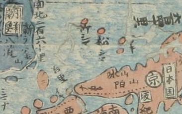
 The following Japanese map is a "Map of Asia and Small Orient(亜細亜小東洋圖)" by Itamiya Zenbei et al.(伊丹屋善兵衛他), and appeared in an 1835 atlas, the historical map, which was entitled "Map of Local and Successive Emperors in China by Province and County" (唐土歴代州郡沿革地図 ). Those are revised map of Nagakubo Sekisui(長久保赤水)'s. The third one is 1857 version, property of individual in Shimane.
The original atlas and map was made in 1789 by Nagakubo Sekisui, and are stored in Japan's National Diet Library. The maps, original and those revised version, show Ulleungdo (竹シマ = 竹島 - Takeshima) and Liancourt Rocks (松シマ = 松島 - Matsushima) in red, which designated them as Japanese territory.
 In 1696, after the dispute on the sovereignty over Ulleungdo between Choson, Bakufu published the ordinance prohibiting voyages to Takeshima ( today's Ulleungdo, not Takeshima/Dokdo). Though Bakufu prohibited (note : not renounced ) two families(Ohya and Murakawa clan) from going to Ulleundo, Matsushima(today's Takeshima/Liancourt Rocks) were not included. Moreover, it is well known that many Japanese kept recognizing both islands within their territory as this map shows through out Edo era.
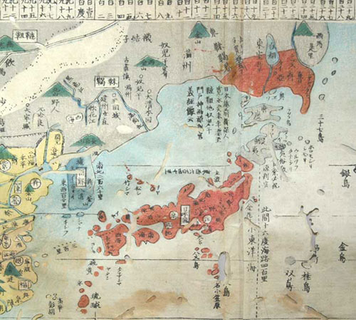 Sekisui is famous for his "Revised Complete Map of Japanese Lands and Roads" (改正日本輿地路程全図). In this map, both Ulleundo and Takeshima/Liancourt Rocks were accurately described. Unlike Korean, who has no record of landing on the island nor having no accurate information on its location and geography, Japanese, Ohyas and Murakawas in Yonago with official licence, had engaged in economical activity on the island. This map was drawn based on various historical documents like their first-hand knowledges and "Ohshu Shicho Gohki(隠州視聴合記)". Though both islands are not coloured, there is a sentence near Ulleundo that says "to see Koryo (from here) is like to see Onshu (Oki island) from Unshu (east of Shimane prefecture, mainland of Japan).(見高麗如自雲州望隠州) ", quoted from "Onshu Shicho Gohki (隠州視聴合記)"(1667).
Not only it confirms that Nagakubo considered both islands as outside Korean (Koryo) territory, but it also confirms that Nagakubo recognized that the oldest, for both countries, official document (Onshu Shicho Gohki) which mentions about sovereign of the island described Matsushima (present Takeshima/Liancourt Rocks) as Japanese territory.
Korean claims because the maps by Nagakubo left both islands uncoloured, the map shows both islands were Korean territory. However, Migohshima(御号島 : today's Okinoshima(沖ノ島)) in Chikuzen(筑前 : today's Fukuoka) was also uncoloured, it is obvious that both islands were not considered to be Korean territory in fact. Later, the revised versions were started to colour both islands as Japanese territory.
 Moreover, Sekisui was in charge of compiling the geographical volume of the "Great Chronicles of Japan"(大日本史 or Dai-Nihonshi) when he worked at the Shōkō Hall (彰考館 or Shōkō-Kan) under President Suiken Tachihara (立原翠軒). The geographical documents were drafted by him. Under the article of 4 of district of Oki country, it says that "in addition, there are Matsushima(today's Takeshima/Liancourt Rocks) and Takeshima(Ulleundo) and those island belong to Oki. (別に松島、竹島があり、これ(隠岐国)に属する(隠岐古記、隠岐紀行、案ずるに隠地郡の福浦より松島に至るには海上69里、竹島に至るには100里4町である。韓人は竹島を称して鬱陵島という。すでに竹島といい、松島といい、我が版図となした。智者を待つが知れない。ついては、以て考えに備える" 隠岐国4郡 項)".
From those facts, it is almost apparent that Nagakubo considered both Ulleungdo and Takeshima within Japanese territory.
Nagakubo Sekisui (長久保赤水 1717–1801) is a Japanese geographer, sinologist and astronomer. He was born as a farmer's child in Mito, today's Ibaragi prefecture. Until then, the maps of Japan were more or less clearly indicating the shape of the country and its different provinces.
However, when Sekisui wrote in 1775 his "Revised Complete Map of Japanese Lands and Roads" (「改正日本輿地路程全図」or Kaisei-Nihon-Yochi-Zenzu), he made history by being the first one ever to mention the geographic coordinates. Thanks to this,the shape of Japan was totally known, with the exception of Ezo area (蝦夷地 now Hokkaido 北海道).
On an accuracy level, his work is inferior to that of Inou Tadataka (伊能忠敬) and his "Maps Inou" (「伊能図」or Inou-Zu, 1821) based on location measurements, but Sekisuki's map is a remarkable and fastidious research work since he wrote it by cross-checking previous works on the subject without proceeding to any measurement. The "Maps Inou" were kept secret by the Shogunate and remained unpublished for a long time whereas Sekisui's maps were printed on a large scale. That is why the "Mito Sekisui Maps" (「水戸赤水図」or Mito-Sekisui-Zu) were widespread until the beginning of the Meiji Restoration (1868).
Sekisui did become famous in the geographical field. However, he was also a Sinologist and became the tutor of 6th Mito Lord Harumori (治保) in his last years. Moreover, he was in charge of compiling the geographical volume of the "Great Chronicles of Japan"(大日本史 or Dai-Nihonshi) when he worked at the Shōkō Hall (彰考館 or Shōkō-Kan) under President Suiken Tachihara (立原翠軒).
---------------------
ReplyDeleteJapan‘s Shogunate declared Takeshima-Ulleungdo (竹シマ) as Korean land in 1696.
Japan's Shogunate again declared Takeshima-Ulleungdo (竹シマ) as Korean land in 1837 and executed Japanese for trespassing on Ulleungdo.
Japan Meiji Govern,ment once again declared Takeshima Ulleungdo (竹シマ) as Chosun land in 1883 and forcibly removed the Japanese trespassers on Ulleungdo.
---------------------------
If the map is true, Japanese ancestors are all liar. Because they betray their words.
So i can not believe in your maps too.
ReplyDeletePlease stop lying.
Hey I got a map just like yours Kaneganese!!
ReplyDeleteThat's strange!! The colours are different on my map.
My maps show Ulleungdo and Dokdo as Korean land.
DokdoIsKorean0
Hey wait I've got another....
DokdoKorean1
DokdoIsKorean2
Oh wait, one more.
DokdoIsKorean3
Sorry, hang on here's another.
DokdoIsKorean4
Ooops one more.
DokdoIsKorean5
Japanese government are faking maps and cheating peoples.
ReplyDeleteAnd pacifist stop lying.
Your lies are already not working.
dokdo-takeshima.com,
ReplyDeleteWhy are you only showing Japanese-made maps to claim that the Liancourt Rocks must have been Korean territory?
Why not show Korean-made maps to clearly and positively suggest that the Liancourt Rocks were Korean?
For poor Korean kids.
ReplyDeleteEven Korean academics doesn't deny the fact that Japanese in Edo era beileved both islands as within their territory and voyageing to both islands yearly. It is a established fact. You don't need to get hysteric to deny it.
Korean logic is, Korean had known the island earlier than Japan, which is unbelivably 512 A.D.!!
If those are not facts, you don't need to insist 石島 in Emperial Edict No. 41 in 1900 is Takeshima/Dokdo, because it means it was only Korean who know the island. Why they can't drop the very weak theory of 石島=Dokdo theory? Because everyone admit Japanese were engaging sealhunting and abalone harvesting on the island as the historical facts.
So it it no use for you kids to scream that they are not true. I think at least you should learn what your government is claiming and their logic.
Your ancestor betray their words.
ReplyDeleteSo, i can not believe in your data.
Poor japanese stop lying.
Dokdo belongs to korea.
Here is my question.
ReplyDeleteIs there any map that meets all the conditions below:
(1) that was made by Korean before at least 1905
(2) that locates precise geographic location of the Liancourt Rocks
(3) that shows the Loancourt Rocks belong to Korean territory
If there is no map that satisfies all three requirements at the same time, Korean claim of sovereignty over the Liancourt Rocks is incredibly weak.
Kaneganese said...
ReplyDeleteEven Korean academics doesn't deny the fact that ...
----------
Korean academics and govermnent never deny that dokdo belogs to korea.
Korea's claim weak??
ReplyDeleteJapan's claim non-existant...
The above poster is dead on. The ghosts of Pacifist's and Kanganese's ancentors betray their words as false.
Hi cloud
ReplyDeleteThank you for using ID...
I was really getting sick of those anonymous teletabbies. How can I identify who is talking what?
Nobody can't present Korean old maps which described today's Takeshim/Dokdo. Because there's none. I couldn't believe my eyes first two years ago when I started to study the issue and got to know this fact.
All the maps Korean present as proof depict Usando as Ulleugdo (-1700s) or Jukdo (1700s-), a rockey, but inhabitable island which locates 2-4 km east of Ulleungdo and almost 100 times bigger than each islets of Takeshima/Dokdo. Usando in some maps did fly around Ullengdo, though. Any of them were far from to be confirmed as today's Takeshima/Dokdo, unfortunately.
I've posted the index of our blog a few entry before. We've peruzed so many old Korean maps. Please see them by yourself and decide who is telling truth.
I'm only posting Japanese maps since I was surprised that Korean kids doesn't know the Japanese claim at all. Or it seems they actually don't know both side's claim. Maybe they are only here to show how Korean kids can behave bad to all over the world.
Here's another question (perhaps off-topic, though).
ReplyDeleteWhat is the official position of Korean government toward the Rusk documents of 1951?
I am also wondering why Wikipedia does not have a Korean page for the Rusk documents.
Rusk documents
http://en.wikipedia.org/wiki/Rusk_documents
Kaneganese,
ReplyDeleteThanks a lot for the post.
I hope all the intelligent Korean people will notice the truth without prejudices.
Please decide by yourself, dear Korean people.
Cloud,
ReplyDeleteThey basically ignore the document. They sick to SCAPIN-677 and SCAPIN-1033. Though they ignore the important part of both of them.
Please read below as well.
1953 Jul 22 - US Doc. Reconfirms Dean Rusk Letter
1954 - Report of Van Fleet mission to the Far East
U.S. basically concluded that Takeshima/Dokdo is Japanese territory. But he dodged the responsibility and told both country to bring it to ICJ to be decided.
pacifist
ReplyDeleteIt's too late and I'm out here. I may be a bit busy for the this weekend holiday until Monday. I'll try to access and post what I wrote as much as possible.
Anyway, have a good holiday!!
Thanks for the follow-up, Kaneganese.
ReplyDeleteLet me summarize again what I wonder at this point.
I don't really see why the "Dokdo-is-ours" advocate have often brought Japanese-made or non-Korean-made maps in order to prove the Liancourt Rocks are Korean.
In my humble opinion, if they want to claim "Dokdo-is-ours," they assume responsibility to bring their own maps and to show the fact. To claim "the Liancourt Rocks were excluded from Japanese maps" does not positively support their claim in any way. That type of method of elimination cannot be legitimate.
Kaneganese, just a point on standard romaji spelling, it is BAKUFU, not BAKUHU.
ReplyDeleteThank you, Matt
ReplyDeleteI tried to log in occidentalism yesterday, but I forgot my password. I'll try again later.
Cloud is the former poster called Raquel
ReplyDeleteShe is the worst anti-Korean racist.
By the way Cloud=Raquel, there are documents showing Koreans were aware of Liancourt rocks at least five years before 1905.
I heard some buzz on the Korean net some people were trying to find you? Are you in Korea?
The Japan Peace Treaty took years to complete and there were many exchanges by many nations.
ReplyDeleteThe Japanese Takeshima lobbyists are trying to tell us just a few confidential memorandums by the Americans should be interpreted to mean the Allied returned sovereignty of Takeshima to Japan. This is B.S.
JapanPeaceTreaty1
Probably the best researched report on U.S.-Japanese relations and Dokdo at this time was written by Mark Lovmo.
JapanPeaceTreaty2
Dear dokdo-takeshima.com,
ReplyDeleteI'm not "raquel." Pleaese don't get the wrong idea on who you are talking to. I'm neither Japanese nor Korean, just one of those who are curious about the issue.
By the way, would you do me a little favor? I assume you know much more about the dokdo-takeshima issue than I do.
Could you tell me where I can find Korean maps (1) that were made by Korean authority before at least 1905, (2) that locate precise geographic location of the Liancourt Rocks, and (3) that show that the Liancourt Rocks belong to Korean. Or, just tell me the names of such maps, please.
Stop bothering Korea!!
ReplyDeleteJapan?!
When asked if there is any Japanese map with Dokdo marked as Japanese land, some Japanese people show the map '亜細亜小東洋圖', which is very antinomic.
ReplyDeletePro-Japanese people have criticized the inaccurate location and size of Usando(=Dokdo) in old Korean maps denying Usando as today's Dokdo. The shape and location of Dokdo in '亜細亜小東洋圖' is much worse.
The map '亜細亜小東洋圖' has a flaw in terms of historical fact. In 1696, Japan’s Shogunate banned Japanese people to go to Ulleungdo because it was Korean land and there's no record any Japanese trespassed to Ullengdo and Dokdo until 1836. In 1836, a Japanese businessman named Hatchiemon was executed because he illegally went to Ulleungdo which was Korean land.
The map '亜細亜小東洋圖' simply shows that the mapmaker had no exact knowledge on Korean ownership to Ulleungdo and Dokdo.
Ullengdo and Dokdo were never a part of Japan until Japan illegally incorporated Dokdo into Japanese land in 1905. It was a justice Japan had to return Dokdo to Korea after losing WW2.
This comment has been removed by the author.
ReplyDeleteNobody would deny “亜細亜小東洋圖” is very shabby and inaccurate when it’s compared with Nagakubo’s map "Revised Complete Map of Japanese Lands and Roads“(改正日本輿地路程全図)of 1779 which is famous for its accuracy.
ReplyDelete“亜細亜小東洋圖” is very weak to support Kaneganese’s comment “it is well known that many Japanese kept recognizing both islands within their territory as this map shows through out Edo era.”
There’s no doubt Nakagubo Sekisui referenced the "Onshu Shicho Goki" (隠州視聴合記)"(1667) which defined the northwest boundary of Japan was Oki Island.
Nagakubo's 改正日本輿地路程全図(1779)
Onshu Shicho Goki(隠州視聴合記)(1667)
Nagakubo‘s "改正日本輿地路程全図" was also referenced by Hayashi Shihei who reconfirmed Ulleongdo and Dokdo belonged to Korea in 1785.
Hayashi’s "A Map of Three Adjoining Countries" (三国接壌地図)
The Japanese in Edo Period including the officials from Tottori Han(Link to The Document of Tottori Han)consistently excluded Dokdo from Japanese land. “亜細亜小東洋圖”is just inaccurate map.
If the links above don’t work, please go to http://truehistoryofdokdoandtakeshima.blogspot.kr. You can find posts related there.
according to this map persists 磯竹島(iso takeshima)울릉도 is also part of Japanese territory, in historically fact it doesn't make sense. because it had never been to Japan's terriory before. but funny thing is when Japanese persist takeshima is their territory, they have never been submitted or showed the map which 松シマ(which japanese claim 'takeshima' today) was solely their territory in Edo era. because if the map also claim '磯竹島' was Japan's territory that is absolutely fake' all of official map shows '磯竹島' have been Korea's territory(even Japanese map too). The map exists which '磯竹島, 松シマ' are both Korean territory, but the map which shows 松シマ is solely Japan's territory it doesn't exist nowhere. among those maps were published before in 1905
ReplyDeleteHello, we are students who are working as 'Korean Youth Interpreters' in Korea. We are a nation with a map posted on its website you the name of the 'Dokdo', the land of the 'Takeshima' emails to ask for modification for the web page.Gon na spend. Dokdo for the government's basic position in the Ministry of Foreign Affairs and Trade, historical, geographic, international law is unique about the obvious traditional territory of Korea.Specified. South Korean government is exercising sovereignty over Dokdo for a firm territory. Dokdo is Korean government for any provocation being determined and will continue to respond to constantly defend our sovereignty of Dokdo will.It is. And the problem is not that it ends up arguing that, but that Japan is making widespread propaganda both internally and externally with incoherent logic. However, the South Korean government virtually controls the Dokdo Korean because it is one response to provocation in Japan is that playing is really the Dokdo to international.In response to a defense because it could make into regions of conflict have been. However, I think Yvonne's false claims are getting worse day by day, and that Korea should respond accordingly. South Korea's Dokdo is Korean territory is secretary of proven from a record of 512, Dokdo is Japanese territory of Japan as compared to the claim is proved.Early 17th century and only heard the case of the claims presented. We have a site as soon as possible for you in this been on the map of Dokdo will modify the name of the request.
ReplyDelete