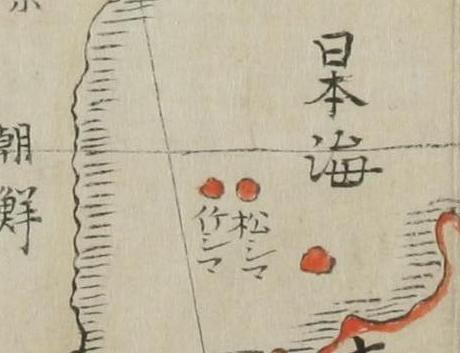
 In 1696, after the dispute on the sovereignty over Ulleungdo between Choson, Bakuhu published the ordinance prohibiting voyages to Takeshima ( today's Ulleungdo, not Takeshima/Dokdo). Though Bakufu prohibited (note : not renounced ) two families(Ohya and Murakawa clan) from going to Ulleundo, Matsushima(today's Takeshima/Liancourt Rocks) were not included. Moreover, it is well known that many Japanese kept recognizing both islands within their territory as this maps shows.
After the Meiji restoration, the names of the islands got confused from the mismapping of non-existant Argonaut in western maps, especially Seibold's. In 1877, Japanese Meiji government officially renounced the sovereignty over Ulleungdo by the Dajokan order (太政官指令). Korean claims that the sentence "Takeshima and another island were not Japanese territory"in the order means Ulleungdo and Takeshima/Liancourt Rocks/Dokdo.
 However, in 1881, Kitazawa, the MOFA official, investigated the confused situation and concluded that "Matsushima" was Ulleungdo and the island that was being called "Takeshima" was Ulleungdo's neighboring island of Jukdo, which is about two kilometers off Ulleungdo's northeast shore. He said that the two islands were not Japanese territory. In the end, the "Takeshima and another island " which Japanese government renounced in 1877, were confirmed to be Ulleungdo and Jukdo afterall.
In 1905, Japanese government officially incorporated Takeshima into Shimane prefecture, because there were no traces of occupation by any other countries except for Japanese fishermen Nakai's business seal hunting hut and economical activity.
 Kimura Kenkado(木村蒹葭堂 : 1736~1802) was born as a descendant of a sake brewer and well informed especially in natural history. He studied Dutch, Latin, did writings and drew pictures. He was a synonym of extensive learning and versatile talent. He knew a lot of writers and artists and his residence was a saloon of men of culture. Nagakubo Sekisui(長久保赤水), a famous geographer, was one of them.
kaneganeseさんヤフー掲示板をみてください
ReplyDeleteyabutarouさん
ReplyDelete今拝見しました。どちらもうまく行ったんですね!!(私はブログに貼り付けようとしたけど出来ませんでした。)今韓国の学校が夏休みに入ってVANKが動員をかけているらしいんです。一人でも見て疑問を持ってくれるといいと思います。後で投稿します。ありがとうございました。
http://www.excite.co.jp/world/korean/
ReplyDeleteyabutarouさん
ReplyDelete以前はYoutubeの映像がここで簡単に投稿できたのですが、今見たら出来ないようです。おかしい。
Kaneganese,
ReplyDeleteThanks for your great posting.
I sometimes find difficulty in viewing Youtube too, maybe due to the installment of new vesion of software.
The map it simply wrong.
ReplyDeleteTakeshima 竹島 on this map is Korean territory. The Japanese confirmed this in 1696.
Whoever drew this map was very misinformed and got a little carried away with his red pen.
That's all
Steve,
ReplyDeleteYou are not a scientific-minded person, aren't you?
As the maps you always bring in won't prove anything about ownership, the map Kaneganese introduced didn't mean Japan owned Takeshima (Ulleungdo).
This map is showing that Japanese people believed that both of Takeshima and Matsushima were Japanese islands, but not official ownership.
Steve, your attitude that things that won't help your theory call "wrong" should be blamed.
Dear pacifist,
ReplyDeletePlease, admit the facts and truth.
Your faked map is no more useless.
Please, do not deny your true history.
anonymous (at 2:32PM),
ReplyDeleteFaked map?
Do you say that Kaneganese forged this map?
Stop talk nonsense and look at the truth.
Dear facifist,
ReplyDeleteI saw japanese maps on korean TV News.
Hmmm... Before and after maps exist in japanese library.
Apparently, japan had faked the maps.
So, i can not beleive in you.
anonymous (at 5:20PM),
ReplyDeleteYou are a miserable guy, if you can't believe the maps in this blog why are you staying here?
And what do you think of this Korean news?
http://dokdo-or-takeshima.blogspot.com/2008/06/1939-jpn-textbook-shows-liancourt-rocks.html
Isn't this a faked map?
I saw japanese maps on korean TV News.
ReplyDeleteHmmm... Before and after maps exist in japanese library.
<- Two maps are exactly 100% same except dokdo. It's faked. I saw it.
Get the point!
I think you're the victims of japanese goverment's brain washing progam.
ReplyDeleteMany maps are faked. Before and after maps exists. And Japanese goverment are cheating peoples.
I hope you find the truth.
If you're not the victims of brain washing program, maybe, you may make peoples brain-washed.
ReplyDeletePlease stop faking and cheating the true history.
This map is a 1790 version and the property of National Archives of Japan(国立公文書館). If anyone has any claim "fake" for this map, please show us the concrete proof. "I saw it on TV"? Well, which program? Please show us the image. Otherwise, I cannot accept your claim. Have you ever heard of the word "slander"? We are having discussion based on evidences, not rumor. This is very serious.
ReplyDeleteAnd everyone, please use ID, not Anonymous. Or I will not make comment on anyone who use "anonymous" anymore.
First, This map is not the map i saw on the TV News. I apologize for that.
ReplyDeleteBut, I saw other maps. It makes me sick.
And you're not admit your nation's data that represent dokdo is korean territory.
How can i believe in your data?
http://news.kbs.co.kr/exec/program/prog_main.php?broad_id=33528
ReplyDelete6. ‘고지도’로 살펴본 독도 영유권 [VOD]
If You click [VOD], you can see what i said.
The map is not faked. The map is simply wrong.
ReplyDeleteThis map cannot be considered an accurate representation of Japan's territorial perceptions.
Japan‘s Shogunate declared Takeshima-Ulleungdo (竹シマ) as Korean land in 1696.
Japan's Shogunate again declared Takeshima-Ulleungdo (竹シマ) as Korean land in 1837 and executed Japanese for trespassing on Ulleungdo.
Japan Meiji Govern,ment once again declared Takeshima Ulleungdo (竹シマ) as Chosun land in 1883 and forcibly removed the Japanese trespassers on Ulleungdo.
Pacifist, any map that shows Takeshima-Ulleungdo as Japanese land isn't worth the paper it was printed on.
Well, Mr Science, if it is not an "official" map how much more weight does it carry than the map below.
DokdoKorean
The map is not faked. The map is simply wrong.
ReplyDelete<- Thanks for teaching me.
Steve,
ReplyDeleteI repeat. If this map is "wrong", then the maps you bring in are not "wrong"?
You call "wrong" at the things against your theory but it is not a scientific way, Steve.
There were many maps in Japan which showed Takeshima and Matsushima.
Steve, you once showed us one of them with Korea, Takeshima and Matsushima were coloured in red. And Kaneganese showed us this map with Japan, Takeshima and Matsushima coloured in red. Why yours are not "wrong" and Kaneganese's is "wrong"?
This map, which Knaganese brought in, showed only that some people in the Edo period believed that Takeshima and Matsushima are Japanese islands. This is the fact, Steve. We are not insisting that Takeshima (Ulleungdo) was Japanese territory. A part of Japanese people believed so, it's a fact.
And we keep saying that a map with Takeshima and Matsushima were coloured in the same colour with Korea is not a proof of ownership, Steve. Please look at the things in scentific eyes, Steve.
Wrong map is no more useless!
ReplyDeleteAnd japanese government must stop faking map!
By the way, the map you posted can be found in its entirety at Mr Tanaka's website.
ReplyDeleteWe know this map is by no means an accurate portrayal of Japan's real territory for a number of reasons.
First, Hokkaido is marked as part of Japan. Though as you mention this map is from 1790 Hokkaido wasn't part of Japan until 1869.
Second the Ryukyus are also part of this 1790 map. In reality Japan wouldn't annex the Ryukyus until 1879.
Third we can see the southern Kuriles are also drawn in this 1790 map as part of Japan. These weren't annexed by Japan until around 1869 and confrimed as Japanese in 1875 by the Treaty of St Petersburg.
Pacifist, maybe some people in the Edo Era believed Ulleungdo was Japanese. Maybe they believed in Santa Claus or the Easter Bunny too, I don't really care. The fact is the map you're posting is not an accurate portrayal of Japan's territorial limits. You are deliberately attempting to mislead people.
Here are Japan's true territorial limits. This was done prefecture by prefecture, remote islands included. These are official complete Japanese Mapbooks.
Japan'sRealTerritory1
Japan'sRealTerritory2
Note there is no Dokdo in any Japanese prefecture despite the fact all very distant remote islands are included.
Stop misleading people Pacifist.
Here is the whole map from Tanaka's website.
ReplyDeleteTanakaMap
You can see it shows Hokkaido, Ryukyus, and southern Kuriles as part of Japan in 1790 even though they weren't really part of Japan.
Either the artist got some new paints for Christmas and got carried away or he was dipping into grandaddy's sake while he was drawing the map.
pacifist, stop brain-washing things.
ReplyDeleteYour lies are not working.
最上得内 also had discribed Takeshima and Matsushima on his map of 『蝦夷風俗人情之沙汰付図』
ReplyDelete『蝦夷風俗人情之沙汰付図』1
『蝦夷風俗人情之沙汰付図』2
sorry for double post
ReplyDelete最上得内----X
最上徳内----O