"East Sea and Dokdo in Old Maps " hosted by the Northeast Asian History FoundationThe exhibition "East Sea and Dokdo in Old Maps " was held by the Northeast Asian History Foundation, that is research laboratories of the South Korea government, from this March 2 to the 9th at the the second floor of National Diet Library in South Korea. However, it made me feel that I was deceived by the extravagant advertisement, since there were only photographed panels in the hall not originals. According to the brochure distributed in the hall and the explanation of the hall, it seems they wanted to claim as follows.
"Regarding the name "East Sea", it is notable that certain old maps printed in European countries such as Germany, Russia and the United Kingdom had used the name even before it was marked as such in the due sea area on some Korean maps for the meaning of "an east side of Eurasia" at that time."As for Takeshima, they also claim that "In the past, Korean called "Dokdo" as Usando, Sambongdo, Gajido or Seokdo", and " on those European old maps, Dokdo is referred to as 'Tchian-chan-tao', 'Liancourt Rocks', 'Hornet Rocks', 'Menelai' or 'Olivutsa'." They also seem to further claim that the label "East Sea" is correct for the Sea of Japan and Takeshima/Liancourt Rocks/Dokdo has historically been Korea's.
However, again, there was no grounds of Korea's claim to show why Takeshima is Korea's and Japan Sea should be called East Sea. Though the brochure says that "the name "East Sea" was marked as East Sea in the due sea area", throughout the Joseon Dynasty, the area of East Sea which corresponds to indicates Yellow Sea(黄海), Bohai Sea(渤海) or the eastern seaboard of the Joseon peninsula and those areas don't overlap the area of the "Sea of Japan". How does the Northeast Asian History Foundation" who sponsored this exhibition take this fact?
Their understanding of East Sea can be inferred from the explanation in the brochure, since they interpret the "Map of the Eight Provinces" (八道總圖 - 팔도총도) from "Sinjeung Dongguk Yeoji Seungram" (新增東國輿地勝覽 - 신증동국여지승람) as follows.
"Map of the Eight Provinces" is the complete map of Joseon which is collected first in the "Sinjeung Dongguk Yeoji Seungram". It only recorded simple information that everyone know, such as prominent mountains, rivers, islands and seas, in order to prevent the top secret of the state."However, this explanation of "Map of the Eight Provinces" is only an arbitrary interpretation that neglects the document criticism. The postspcript of the map says "The complete map is a record for the ritual of worship(祀典)", meaning that the objects that the nation enshrines as spirits/gods of the nature are depicted in "Map of the Eight Provinces". Which means that the "East Sea" in not the label for the name of the sea, but for the places where the shrines of gods/spirits of the sea-waves along the eastern seaboards of Choson peninsula.
In fact, "The map of Kanwondo" from the same "Sinjeung Dongguk Yeoji Seungram" etc. labels the ocean as "東抵大海" (to the East, it reaches to the ocean) and "東北抵大海" (to the Northeast, it reaches to the ocean), making it clear that they are not coastal part, but the open seas far from the land. In short, the majority of the Sea of Japan area was recognized as "大海"(ocean), not "東海(East Sea)" in those old Korean maps.
Moreover, the "East Sea"(東海) defined in the worship(祀典) can be also confirmed in the "Samguk Sagi"'s Monographs part (三国史記 雑志) that was compiled in Goryeo era. And it indicates the coast part of the Korean peninsula's east shore throughout the age of Silla, Goryeo and Joseon. Against this historical fact, Korea's Northeast History Foundation misread the Chinese character "東海", replacing with "日本海"(the Sea of Japan) in the modernistic way of thinking, and falsely claimed that "東海" in the maps are the historical evidence to show ancient Korean called the Sea of Japan as East Sea. However, it was after modern ages that the name's of the Sea of Japan as East Sea became general, and East Sea until a Joseon age indicated the coast part of the Korean peninsula east shore, Yellow Sea and Pohai.
The similar example of their stretching interpretation "East Sea" far to the Sea of Japan can be seen in their explanation of "A Map of Marco Polo's Voyages" as well. The map was produced by British Emanuel Bowen in 1744 and it labeled the area as "EASTAN SEA" on the are of the Sea of Japan. They explained it is the evidence that western society called the Sea of Japan as East Sea in the brochure. However, as was explained, Korea's "East Sea" indicated the coastal part of Korean peninsula's eastern part, and it doesn't overlap with "EASTAN SEA" that corresponds to the Sea of Japan. And yet from the point that "EASTAN SEA" actually is written in "A Map of Marco Polo's Voyages", it should be translated rather as "Eastern Sea" or "Sea in the East" to follow the Marco Polo's "The Book of Marco Polo" which is nicknamed as " Oriente Poliano". But they explain it as "regarding the name "East Sea", it is notable that certain old maps printed in European countries such as Germany, Russia and the United Kingdom had used the name even before it was marked as such in the due sea area on some Korean maps" without any fact as such, in their brochure and the board on the hall. It is because there are overwhelmingly numbers of western old maps which label the sea area concerned to be "Sea of Japan", "Goryeo sea" and "Joseon sea", but "East Sea".
Therefore, the exhibition "East Sea and Dokdo in Old Maps " will, on the contrary to their expectation the world to correct the Sea of Japan as East Sea, have proven the fact that East Sea claimed by South Korea doesn't overlap with the Sea of Japan. Keeping fabricating the history of the lie, and cheating the inside and outside the country only complicate relations between Japan and South Korea fruitlessly. This kind of political advertisement never leave an excellent result to future generations, but simple international reliability to South Korea is lowered and the stain is left for the history, .
It is necessary to clarify to which of historical titles of Takeshima in Japan-South Korea to belong when the Takeshima Issue as the history issue is discussed. They dissemble as if Korea's historical base on Takeshima/Dokdo sovereignty is well-grounded, by explaining that Liancourt Rocks have been "called as Usando, Sambongdo, Gajido and Seokdo, etc..." and the islets were labeled as "Tchian-chan-tao、Liancout Rocks、Hormet Rocks、Menelia or Olivutsa, etc... in old western maps." However, unfortunately, there is anything that shows Korea's historical title on Takeshima at all.
The same thing goes to their other explanation that "the claim by Japanese Government that Japan had owned Takeshima before 1905 is false" because "The map of the Great Japan", which the bureau of the staff of a Japanese army(日本陸軍参謀局) produced in 1877, does not depict Takeshima. This kind of sophistry comes from the disregard for the historical fact as is explained later.
Although Korean claim that they called today's Takeshima as Usando, Sambongdo, Gajido and Seokdo, etc...", but that is absolutely groundless as I have already proved empirically in my article "A Study on the Name of Dokdo". Accordingly, as far as Korean has been keep failing to prove they had owned Takeshima/Dokdo before 1905, the year Japan officially incorporated Takeshima into Shimane Prefecture, Korea does not deserve to criticize Japan. The exhibition and their sophistry practically prove that they don't understand the historical background of Takeshima Issue at all. The origin of the issue can be traced to 18th January, 1952, the day Korean government installed the illegal delineation "The Syngman Rhee Line", encompassing the island of Takeshima and a large area of water with fisheries jurisdiction, over international waters. Afterwords, South Korea was yet able to prove it was historically Korea's territory, and all they talk was big brag "The territorial issue doesn't exist between Japan-South Korea", though the government of two countries exchanged memos, and repeated a formal controversy until the 1960's. This is the reason the government of Japan accuse Takeshima occupation in 1954 by South Korea to be an illegal occupancy.Korea's Takeshima/Dokdo Research has been carried out on the assumption that "Dokdo is our territory (Takeshima is South Korea's territory)", and they interpreted documents and old maps, which has no competence to prove the sovereignty in the first place, arbitrary to claim their legitimacy. The exhibition "East Sea and Dokdo in Old Maps " fall under this category. The background why such events are repeatedly held is it originates in the fact that the past Takeshima controversy between Japan-South Korea was irregular.
Although it is already proven that Takeshima was not Korea's territory in the view of history, there are two opinions concerning of the Takeshima Issue. Shimane Prefecture's Takeshima Research Center, that summarized the point of issue, concluded that Takeshima is Japanese territory on the ground the fact then Meiji government named Liancourt Rocks, of which there were no traces of occupation by any other countries / Terra nullis, and incorporated into a Japanese territory in accordance with International Law in 1905. While Ministry of Foreign Affairs of Japan concludes that Takeshima is Japanese territory from Edo period, from the details of the controversy by the exchange of memos of Japan-South Korea so far.
Then, South Korea that wanted to refute the Japan's claim at any cost disregarded the opinion of the Takeshima Research Center of Shimane Prefecture and made the opinion of the Ministry of Foreign Affairs a subject of discussion. This time, they presented "The complete map of Japan"(大日本全図) as the grounds of an argument that the bureau of the staff of a Japanese army(日本陸軍参謀局) produced in 1877. According to their explanation, it supposed to be "the proof of Japanese Government's opinion that Japan had owned Takeshima before 1905 is false" since Takeshima was not depicted.
However, it is natural that Takeshima that became a Japanese territory in 1905 doesn't exist in the map of Japan produced before 1905. No matter how maps that similar to this "The complete map of Japan" are collected, it hardly become any evidence to prove Takeshima is South Korean territory. South Korea's, who lacks empirical evidence to prove Takeshima is South Korea territory, claim that "Japanese government claim falsely" is just a propaganda maneuvers to justify their illegal occupancy of Takeshima. "False claim" is not on Japanese side, but on Korean side, who herself accuse Japan of false claim.In fact, there is Korea's deceit behind the words the brochure says, "Dokdo is referred to as 'Tchian-chan-tao', 'Liancourt Rocks', 'Hornet Rocks', 'Menelai' or 'Olivutsa' in western old maps." The name "Liancourt Rocks" originate from the fact French whaler Liancourt found the islets in 1849. "Hornet Rocks" originate from the fact that British warship H.M.S. Hornet identified them and plotted on the nautical-chart in 1855. "Menalai and Olivutsa Rocks" again originate in the fact Russian frigate Paleada have surveyed the island and named it Olivutsa(Оливуца) & Menelai(Менелай) in 1854. Accordingly, there are concrete reason that Takeshima/Dokdo was named as such in western old maps. The point is, "Tchian-chan-tao" (the sound of the Chinese word "千山島") is not today's Takeshima/Dokdo. "Tchian-chan-tao" in western old maps comes from "Map of the Eight Provinces" (八道總圖 - 팔도총도) in ”A Revised Edition of the Augmented Survey of the Geography of Korea” (新增東國輿地勝覽 : The Sinjeung Dongguk Yeoji Seungram) indicates "千山島" and it does correctly indicates "千山島". However, "千山島" in "Map of the Eight Provinces" is the same island with different names of Ulleungdo, and it has no relationship with Takeshima in territorial dispute between Japan-Korea. "千山島" in "Map of the Eight Provinces" is depicted between Joseon peninsula and Ulleungdo, and it is apparent from the description of "Annals of King Taejong" (太宗實錄 - 태종실록) , which was quoted in ”The Sinjeung Dongguk Yeoji Seungram”, that it was another name of Ulleungdo. However, problem is, the incorrect geographical knowledge of "Map of the Eight Provinces" was followed suit by western old maps (Note by translater ; via China) and Usando, which is the same island/different name of Ulleungdo, imparted to as well. "Royaume de Coree" by French royal geographer D'Anville in 1737, which was on display at the exhibition, is one of those maps and it is the ringleader who confuses the Western old maps. "The Chart of Japan" by William Heine, who accompanied the first expedition of the US fleet under Commander Matthew Perry to Japan as an official artist/book illustrator in 1853, depicts three islands, "Takeshima"(Argonaut=non-existant),"Matsushima"(Ulleungdo/Dagelet), "Hornet Rocks"(today's Takeshima), plus two islands "Pan-ling-tao", which indicates Ulleungdo and "Tchian-chan-tao" which originates in "千山島" in the vicinity of the East coast of Joseon peninsula. Same goes to "(U.S) Navy Chart of the Coast of China 、Pacific coast (Asia), Japan islands Copied to ordered by Commandar Mattew Perry(1855)", a foldout map in "The Narrative of the Commodore Matthew Calbraith Perry's Expedition to Japan", and it depicts two Ulleungdos, namely "Dagelet or Matsushima"(=Ulleungdo) and "Pan-ling-tao"(=Ulleungdo), following the geographical knowledge of "Royaume de Coree" by D'Anville.
The exhibition "East Sea and Dokdo in Old Maps " held by the Northeast Asian History Foundation arbitrarily decide ”Tchian-chan-tao” in "Royaume de Coree" by D'Anville is today's Takeshima, but in fact, ”Tchian-chan-tao” only followed the mistake of "Map of the Eight Provinces". Therefore, it can never become a evidence for Korea's sovereignty over Takeshima.
Korean side claim Takeshima is their territory by arbitrary interpreting the documented source or old maps neglecting document criticism, however, this kind of claim, which lacks the technique of a fair historical study, is nothing but just a reckless remark."The New Detailed Map of Japan, Russia, China and Korea"(日露清韓明細新図) which Korea's Dokdo Institute of Yeungnam University opened on this April 1 to the public is not the exception. The map is written as to have been produced by "The Department of Survey of Imperial Army/
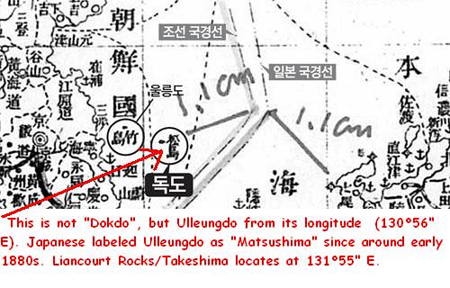
Navy"(帝国陸海測量部) in 1903, and borderline is appearing between Japan and Korea with "Takeshima" and "Matsushima" on Korean side. Dokdo Institute of Yeungnam University claimed that the map "depict what Japanese call "Takeshima=Ulleungdo" and Matsushima=Dokdo" belong to Joseon territory", and Kim Hwa-Kyung(金和経), the head of the Institute, said that "Japan should discontinue the insistence on the sovereignty over Dokdo in the situation with evidence Japan himself divided the border voluntarily recognizing the South Korean territory Dokdo". (Note by translator : There was no such department as "The Department of Survey of Imperial Army/Navy"(帝国陸海測量部) in Military history of Japan. This handy map is apparently produced by non-official Mr. Kurimoto(東京日本橋:栗本長質), the private mapmaker who seems to have tried to sell the map under a fake official name. The map is made for the soldier who goes to war to the oversea land. )However, "Takeshima" and "Matsushima" in "The New Detailed Map of Japan, Russia, China and Korea"(日露清韓明細新図) are phantom island "Argonaut" and "Ulleungdo", respectively, apparently from their longitude. Because, Ulleungdo had been recognized as "Matsushima" in Japan since about 1883(16th year of Meiji). The remote cause of the confusion is Philipp Franz von Siebold's map "Karte vom japanischen Reiche, nach Originalkarten und astronomischen Beobachtungen der Japaner die Inseln Kiusiu, Sikok und Nippon"(1840) , which depicts "Takasima (I. Argonaute)", the island of uncertain whereabouts (129°50" E) and Ulleungdo as "Matsusima (I. Dagelet)" (130°56" E). Therefore, after this Siebold's map, western maps and charts depict phantom island "Takeshima=Argonaut" and "Matsushima=Dagelet", which is Ulleungdo, and Japan followed it. Takeshima, which is currently occupied illegally by South Korea, locates at 131°55" E. Accordingly, it has nothing to do with "Take(a)sima" (129°50" E) nor "Matsusima" (130°56" E) in Siebold's map "Karte vom japanischen Reiche, nach Originalkarten und astronomischen Beobachtungen der Japaner die Inseln Kiusiu, Sikok und Nippon"(1840).
Therefore, "Takeshima" and "Matsushima" in "The New Detailed Map of Japan, Russia, China and Korea"(日露清韓明細新図) (1903) are phantom island "Argonaut" and "Ulleungdo", respectively, and it is also apparent from their longitude and latitude. For that reason, it is prejudiced opinion to disregard the fact of the history for Kim Hwa-Kyung(金和経), the head of the Institute, to have said that "It is the evidence Japan himself divided the border voluntarily recognizing the South Korean territory Dokdo". Takeshima/Liancourt Rocks, which used to be called as "Matsushima" by Japanese in Edo era, was officially named as "Takeshima" when it was incorporated into official Japanese territory in 1905, being switched by the old name of Ulleungdo, which used to be called as "Takeshima", because of mislabel of Ulleungdo as Matsushima in Siebold's map "Karte vom japanischen Reiche, nach Originalkarten und astronomischen Beobachtungen der Japaner die Inseln Kiusiu, Sikok und Nippon"(1840).
"Takeshima" and another island = "Matsushima" of the Dajokan instruction, which Korean frequently takes up for a subject for discussion, simply meant that phantom island "Takeshima" and "Matsushima" as a another name of Ulleungdo, and it didn't instructed that today's Takeshima to be outside the territory of Japan. South Korean seems tend to interpret documents and maps recklessly in order to make Takeshima/Linancourt Rocks is Korea's territory. However, it is impossible and unreasonable for them to claim Takeshima which have never been their own territory in the first place, as their own.
Finally, both the exhibition "East Sea and Dokdo in Old Maps" and the Dokdo Institute of Yeungnam University are interpreting documents and a part of the old map arbitrary, and fabricating the history of the lie. This kind of act will leave the wound with irreparable relations between Japan and South Korea. This is a reason to dare to give unpleasant but wholesome advice.
“実事求是 〜日韓のトゲ、竹島問題を考える〜 第26回 「東北アジア歴史財団」主催の「東海独島古地図展」について 下條正男”
Courtesy of Web Takeshima Research Center.
The 25th column “"Opinion Ad by The Unity of Asian Peace and History Education"”
The 22th column “ Refutation against "The Meiji Government's recognition of Takeshima=Dokdo" by Mr. Park Byeong-seop(朴炳渉)””, Part 1, Part 2, Part 3, Part 4The 21st column " Refutation against "Analysis of Shimojo Masao's Editorials" by Mr. Park Byeong-seop(朴炳渉)”
The 20th column “Act of Folly by "Northeast Asian History Foundation"”
The 16th column ""Dokdo Month" without any historical grounds."
The 15th column " South Korea's Groundless Claim of "Inherent Part of (Korean) Territory"
The 12th column “Northeast Asian History Foundation and Dokdo Research Center's Misunderstanding”
The 10th column " A Blunder of Sokdo(石島) = Dokto(独島) Theory”
The 9th column "Criticism on Dokdo Research Center”
The 8th column “The Historical Facts" The 6th column “Onshu-shicho-goki (隠州視聴合記)" and the "Nihon Yochi Totei Zenzu (日本輿地路程全図)" by Nagakubo Sekisui(長久保赤水)"The 5th column “South Korea’s erroneous interpretation of the document 'Takeshima and Another Island are Unrelated to Japan"
The 4th column “Errors in Educational Video Produced by the Northeast Asian History Foundation (東北アジア歴史財団)."
References ;
1817 - Aaron Arrowsmith's map of Japan and Von Siebold
1877 - Argument about "another island": details of the compiled official documents (公文禄) of the Ministry of the Interior (太政官指令)
1880 - Japanese Warship "Amagi" (軍艦天城) Surveys Ulleungdo and finds "Takeshima" is Jukdo.
「竹 島外一島之儀本邦関係無之について」再考−明治十四年大屋兼助外一名の「松島開拓願」を中心に−
2008-下條正男「独島呼称考 : 韓国政府版「独島:六世紀以来韓国の領土」批判」
correction
ReplyDelete"Neither "Takeshima" nor "Matsushima" of the Dajokan instruction, ..."
→
""Takeshima" and another island = "Matsushima" of the Dajokan instruction, "
08/06/2010
a)1863年の英国海軍海図2347号の輪郭
ReplyDeleteb) a に今回の1894年の日本朝鮮支名三国地図をPlot
竹島はArgonaut島、松島はDagelet鬱陵島になります。
Kaneganese are you still selling Professor Shimojo’s snake oil again? Tell your boss everyone West of Shimane Prefecture isn’t buying it.
ReplyDeleteThe interpretation of Japanese maps should be done carefully and we can make some generalization about cartographers during history.
Japanese mapmakers had little knowledge of Ulleungdo’s and Dokdo’s real forms or even accurate location. The first Japanese maps showed Dokdo as too far from Korea (East) and incorrectly shaped.
Note the shape of Ulleungdo and Dokdo is wrong.
http://www.dokdo-takeshima.com/wordpress/wp-content/images/nagakubo-sekisui-ull-dok.jpg
Even 60 years later the Japanese would copy Nagakubo Sekisui’s incorrect shapes and locations.
http://www.dokdo-takeshima.com/wordpress/wp-content/images/ull-dok-oki-col-2.jpg
Many Japanese maps of the 19th Century show Takeshima as Ulleungdo NOT a ghost island.
http://www.dokdo-takeshima.com/wordpress/wp-content/images/seibold-study2.jpg
http://www.dokdo-takeshima.com/wordpress/wp-content/images/seibold-study9.jpg
http://www.dokdo-takeshima.com/wordpress/wp-content/images/so-mokan.jpg
GTMOR look closely at your map link you posted.
As with almost all three island maps of the 19th Century next to Argonaut Takeshima we can see the letters “PD” this means “Position Doubtful” meaning whoever drew this map knew Argonaut was non existent.
http://www.dokdo-takeshima.com/wordpress/wp-content/images/1863-japan-map-pd.jpg
By the mid-1850s the Argonaut mystery had been solved by even the Europeans and we know that Japan was aware of this error too.
http://www.dokdo-takeshima.com/wordpress/wp-content/images/1855-map-3.jpg
http://www.dokdo-takeshima.com/wordpress/wp-content/images/1855-heine.jpeg
Mapmakers of the 19th Century were not historians or surveyors they usually copied maps made from earlier charts. We know the origin of these mistakes (Seibold)
Japanese map makers for centuries mapped two islands in the East Sea. Ulleungdo and Dokdo they had little real knowledge of the islands true shapes or locations. However, they frequently showed Matsushima (Dokdo) as Korean and not as Japanese.
The Japanese bizarre interpretation of Meiji Era maps is Japan’s mapmakers knowingly omitted an island they mapped consistently for 150 years (Dokdo) and drew Ulleungdo twice is nonsense.
連合ニュース、保坂教授がまたまた不思議な主張をしています。
ReplyDeleteラスク書簡の「克服」は国をあげての課題のようです。
http://www.yonhapnews.co.kr/society/2010/06/09/0701000000AKR20100609120200004.HTML
2010/06/09 13:04 송고 送稿
"`독도는 일본땅' 러스크 서한은 美 월권행위"
「『独島は日本領』ラスク書簡は、米の越権行為」
保坂教授「連合国の合意なしに作成し、韓国にだけ伝達」
호사카 교수 "연합국 합의 없이 작성해 한국에만 전달"
(ソウル=聯合ニュース)キム・ゲヨン記者
(서울=연합뉴스) 김계연 기자
日本が独島領有権を主張する根拠に利用するいわゆる「ラスク書簡」は、日本領土の範囲を共に決めることにした連合国との合意なしに作成され、無効だという主張が提起された。
일본이 독도 영유권을 주장하는 근거로 이용하는 이른바 `러스크 서한'이 일본 영토의 범위를 함께 결정하기로 한 연합국과 합의 없이 작성돼 무효라는 주장이 제기됐다.
ラスク書簡は、第2次世界大戦の連合国と日本がサンフランシスコ講和条約を結ぶ直前の1951年8月10日、当時のディーン・ラスク(Dean Rusk)米国務部極東担当次官補が、梁裕燦(ヤン・ユチャン)駐米韓国大使に送った手紙で、「独島は朝鮮の一部として取り扱われたことがなく、1905年頃から日本の島根県の管轄下にある」という内容を含んでいる。
러스크 서한은 제2차 세계대전 연합국과 일본이 샌프란시스코 강화조약을 맺기 직전인 1951년 8월10일 당시 딘 러스크(Dean Rusk) 미 국무부 극동담당 차관보가 양유찬 주미 한국대사에게 보낸 편지로, `독도는 조선의 일부로 취급된 적이 없고 1905년경부터 일본 시마네현의 관할 하에 있다'는 내용을 담고 있다.
世宗大学・独島総合研究所長の保坂祐二教授は、9日午後、大学校内の君子館で「ラスク書簡の分析と克服」というテーマで市民講座を開き、「米国が、ラスク書簡を連合国も知らせずに作成し、韓国大使館にだけ送ったことは、日本の領土を連合国が決めることにしたポツダム宣言を破った越権行為だ。」と規定した。
세종대 독도종합연구소장 호사카 유지 교수는 9일 오후 교내 군자관에서 `러스크 서한의 분석과 극복'을 주제로 시민강좌를 열어 "미국이 러스크 서한을 연합국도 모르게 작성해 한국 대사관에만 보낸 것은 일본의 영토를 연합국이 결정하도록 한 포츠담 선언을 어긴 월권행위다"고 규정했다.
保坂教授はこの主張の根拠として、1952年11月、アラン・ライトナー(Allan Lightner) 駐韓米国大使館臨時代理大使が、ラスク書簡の内容を伝達されて国務省に送った手紙を提示した。
호사카 교수는 이 주장의 근거로 1952년 11월 앨런 라이트너(Allan Lightner) 주한 미국대사관 임시대리대사가 러스크 서한의 내용을 전달받고 국무성에 보낸 편지를 제시했다.
ライトナー代理大使は、ケネス・ヤング(Kenneth T. Young) 東北アジア課長に送った手紙で、「国務省は、この問題に関し明白な立場を取ったラスク書簡が、韓国大使宛てに送られたという話を聞いたことがない。我々が、永い間、間違った仮定の上に活動してきたことを考える時、情報を得て非常にうれしく思う」と書いた。
라이트너 대리대사는 케네스 영(Kenneth T. Young) 동북아과장에게 보낸 편지에서 `국무성이 이 문제에 관해 명백한 입장을 취한 러스크 서한이 한국대사 앞으로 보내졌다는 이야기를 들은 적이 없다. 우리가 오랫동안 틀린 가정 위에서 활동해온 것을 생각할 때 정보를 얻어 매우 기쁘게 생각한다'고 썼다.
ラスク書簡は、内容を最もよく知っていなければならない米国の駐韓大使にすら伝えられたことがない、非公開文書だったのだ。
러스크 서한은 내용을 가장 잘 알고 있어야 할 주한 미국대사에게도 전달된 적이 없는 비공개 문서였다는 것이다.
保坂教授はまた、1953年11月に作成された米国務省の内部文書を提示し、ラスク書簡は、他の連合国との合意なしに作成され、公開もされなかったことを示すと主張した。
호사카 교수는 또 1953년 11월 작성된 미 국무성의 내부문서를 제시하며 러스크 서한이 다른 연합국과 합의 없이 작성됐고 공개되지도 않았음을 보여준다고 주장했다.
この文書には、「衝突が繰り返されるならば、我々はラスク書簡を公開してその内容を明らかにせざるをえず、韓国政府がこれを受け入れることが出来ないならば、調整や国際司法裁判所行きを考慮しなければなければならないと提案するだろう」と記されている。
이 문서에는 `충돌이 되풀이된다면 우리는 러스크 서한을 공개해 그 내용을 말하지 않을 수 없고 한국 정부가 이를 받아들일 수 없다면 조정이나 국제사법재판소 행을 고려해야 한다고 제안할 것이다'라고 적혀 있다.
彼は「独島が日本領土であるという米国の立場は、今まで一度も日本政府に正式に伝えられたことがない」という内容のまた別の米国務省文書、及び「米国の立場は大韓民国に秘密裏に通知されたが、私たちの立場はまだ公表されたことがない」と書かれたジェームズ ・ヴァン・フリート(James van Fleet)特使の帰国報告書も例にあげ、「日本や連合国にも知らせずに独島の帰属を定め、韓国にだけ通知したもので、不法ありで無効である」と指摘した。
그는 `독도가 일본 영토라는 미국의 입장은 지금까지 한 번도 일본 정부에게 정식으로 전달된 적이 없다'는 내용의 또다른 미 국무성 문서와 `미국의 입장은 대한민국에 비밀리에 통보됐지만 우리의 입장은 아직 공표된 바가 없다'고 적은 제임스 밴 플리트(James van Fleet) 특사의 귀국보고서도 예로 들며 "일본과 연합국 몰래 독도의 귀속을 정하고 한국에만 통보했기 때문에 불법이고 무효"라고 지적했다.
彼は、日本が「ラスク書簡を10ヶ国語に翻訳して外務省のホームページにのせ、独島領有権を主張している」として、「韓国政府もラスク書簡のこういう性格を外交通商部の独島サイトにのせ、日本の論理を撃破しなければならない」と付け加えた。
그는 일본이 "러스크 서한을 10개국어로 옮기고서 외무성 홈페이지에 올려 독도 영유권을 주장하고 있다"며 "한국 정부도 러스크 서한의 이런 성격을 외교통상부 독도사이트에 올려 일본의 논리를 격파해야 한다"고 덧붙였다.
↑ これ、いいですねえ。「ラスク書簡」とか「国際司法裁判所」とかいう言葉が改めて韓国人の間に広まることでしょう。
ReplyDelete2010.06.09
matsu様に質問なのですが、
ReplyDelete以前、Rusk noteがDullesの話として社会党かどこかが塚本氏以前1970年代に発表していたとの話し、投稿されていたと思いますが、どこに投稿されたのかご教示願えれば幸いです。
「日本の領土を連合国が決めることにしたポツダム宣言を破った越権行為だ」とホサカ氏は指摘しているが、米国には極東委員会の決定を経ないで占領政策を進める権限が与えられていたので、氏の指摘は当たらない。これが無効というのなら、日本の対朝鮮請求権放棄の約束も無効になるのだが、良いとこだけつまみ食いするつもりなのだろうか?
ReplyDelete「ラスク書簡は無効だ」という訴えを国際司法裁判所に持ち込むことを勧める。そこで勝訴すれば日本の減らず口に蓋をできるぞ。ガンバレ!!
2010.6.10
ワシントン独島守護特別対策委員会が先月20日にワシントンでシンポジウムを開催したのだとか。ホサカ氏の動きはそれを受けてのことなのでありましょう。
ReplyDeleteちなみに、パネリストは以下の通り。
*ジョシュア・カステリノ(Joshua Castellino)教授(ミドルセックス大学)「領土に対する権原確立:国際司法裁判所の法理」
*ミノル・ヤナギハシ(Minoru Yanagihashi)前教授(アリゾナ大学)「サンフランシスコ平和条約と領土問題」
*池漫郊(Chi Manjiao)博士(中国国際法アカデミー)「独島と有事紛争解決のため新しいアジア的接近」
*ラウル・ペドロゾ(Raul Pedrozo)教授(Naval War College)「世界2次大戦以前の独島領有権問題」
*キム・ピルギュ名誉教授(メリーランド大学)「サンフランシスコ条約と独島領有権:国際法上の解釈と分析」
このパネリストたちがどんな論理を展開したのか興味あります。情報お持ちの方おられますか?
とりあえず、Minoru Yanagihasiが出てきません。
ReplyDeleteJoshua Castellino middlesex univ.
池漫郊/Xiamen univ/
国際商事仲裁法研究
主要研究领域为国际仲裁,国际经济法(国际合同,国际投资法)以及国际公法基本理论。
Raul Pedrozo Naval War College
この方についても、Naval war collage内で検索をかけてもかかりません。
こんなのがありました。↓
ReplyDelete“韓国の独島支配 認めなければならない”
2010-05-21 KOREANTIMES(米州韓国日報)
独島特委、ワシントンで第2回年例シンポジウム
国際学者、領有権問題を国際法に基づいて検討
独島領有権は、国際法上の「占有物留保原則(uti possidetis)」によって、現在独島に対する主権を行使している韓国にあるという指摘が出た。
ワシントン独島守護特別対策委員会(会長チェ・チョンポム)は、20日、ワシントン DC 所在ナショナルプレスクラブで開催した「第2回国際独島シンポジウム」でジョシュア・カステリーノ教授(ロンドン・ミドルセックス大学)は、「韓国も日本も自己の主張を証明できる歴史的な資料を提出することができる状況において、ローマ法に根拠したこの原則は尊重される必要がある。」としてこのように述べた。uti possidetisとは、「領土や財産などは条約(treaty)によって他の規定が整備されない限り、紛争終了時現在の所有者に帰属する」と言う原則だ。
彼はまた、「日本は韓国を併合するのに先立って1905年に独島を先に編入したと言うが、これは韓国を合邦する一過程だったので、韓国の完全な独立を保障したサンフランシスコ平和条約によってこれも無効になる。」とし、1905年の独島編入は領有権主張の根拠資料にならないと付け加えた。彼はまた、「1951年に作成されたサンフランシスコ平和条約が韓国に帰属するすべての領土を明示していないところで、日本と戦った連合軍諸国の独島に対する立場が皆同じだとは限らない。」と国際司法裁判所(Internat ional Court of Justice) など国際機関の仲裁と交渉を通じて持続的に解法を捜す必要があることを強調した。
国際専門家たちを招待して独島領有権問題を深く考察してアメリカ主流社会に独島を巡る諸問題を正しく知らせようという主旨で開かれたシンポジウムには、ジョシュア・カステリーノ教授を始め、キム・ピルギュ教授(メリーランド大学)、日系ミノル・ヤナギハシ教授(アリゾナ大学)、マンジャオ・チ教授(シアメン国際法大学) など国際法と領土紛争関連の専門家たちが多数招請されて熱い討論を交わした。
キム・ピルギュ教授は、「サンフランシスコ平和条約は独島に特別に言及していないと言うが、条約の本来の意味を常識に基づいて解釈すれば良い。」とし、「韓国の独立に伴って、独島は当然韓国に帰属されるもの」と念を押した。これと共に、キム教授は、1905年に日本が独島を編入したという主張にも、新羅時代の歴史に言及された独島の記録などに言及しつつ、独島は一度も韓国の歴史において「放棄された(abandoned)」ことはなく保護されて来たことを強調した。
一方、ミノル・ヤナギハシ教授は、「サンフランシスコ平和条約以後に国際的に締結された多くの条約は独島領有権帰属問題を明確にしておらず、アメリカなど強大国の政策立案者たちも、理念の影響によって視覚を異にして現在まで論難を生んでいる。」と述べた。彼はまた、「独島領有権論争は、結局、国家的自尊心と威信がかかっている象徴的な問題」とし、余りに現実的な接近は正しくないことを指摘した。
マンジャオ・チ教授は、日本と類似の領土紛争を経験している中国の立場から独島問題に深い関心があることを示唆しながら、「サンフランシスコ平和条約は基本的に遵守されなければならないが、地域的、文化的に西方世界とは違いがある状況を考慮して、両国関係の未来を考慮して長期的な視点から解いて行かなければならない。」と提案した。
キム・ヨンホ独島特委広報委員長の開会で始まったシンポジウムは、マイケル・デービス教授(香港中国大学)が司会を引き受け、イ・ムンヒョン教育委員長、イ・ジェス運営委員など独島特委関係者たちとファン・ウォンギュン北部バージニア韓人会長、イ・ネウォンワシントン韓国学校協議会理事長など多数の韓人人士が参加して関心を見せた。
2010.06.10
GTOMRさま
ReplyDeletehttp://dokdo-or-takeshima.blogspot.com/2010/01/1953-28.html
現状で、うしろから4番目のコメントです。今年の2月17日に投稿していました。再掲します。
・・・・・・・・・・・・・・・・・・・・・・・・・・・・・・・・・・・・・・
ラスク書簡の紹介ですが、上記1984年の塚本論文より早く、
1978年7月に次のような論文がありました。
花井浩司「竹島解決への新たな提案」(今日の焦点 国際)『月刊社会党』日本社会党中央本部機関紙局1978年7月 通号261
http://opac.ndl.go.jp/articleid/1889116/jpn
以下引用
180p
最近「1951年の米外交文書」が公表されたが、ヤン駐米韓国大使が竹島の領有権を主張したのに対し、ダレス国務長官は「われわれの情報によれば、竹島は1905年頃から韓国の一部として扱われたことがなく、島根県陰岐支庁(ママ 隠岐支庁か)の管轄下におかれている。それ以前においても韓国が領有を主張したことはない」と日本の固有の領土であることを韓国側に通告している。(51・8・10国務省覚書)
この論文の著者は、「花井浩司 国際問題研究家」とあります。
『月刊社会党』は社会党の機関紙ですが、花井浩司という人は国際問題の担当だったようです。国会図書館の論文リスト(雑誌記事索引)によれば、時事的な国際問題を継続して扱っていた人のようです。
この論文では、竹島問題を、国際司法裁判所に「応訴管轄(フォルム・プロロガチューム)」という原則により提訴することを提案しています。
この原則は、当事国間に合意の意思が存在せず、相手国の応訴の意思が不明なままに他方の当事国が一方的に国際司法裁判所へ提訴し、訴えられた国が、後から応訴の意思を示し裁判が成立することをいうものだそうです。
「応訴管轄(フォルム・プロロガチューム)」ということについて、よく知りませんが、どなたか教えてください。
2010.02.17
・ ・・・・・・・・・・・・・・・・・・・・・・・・・・・・・・・・・・
2010.06.10
日本の外務省がやるべきことは、これらの「国際専門家」のパネリストの学者たちに、
ReplyDelete①英文で書かれた、
②一次史料の載った、
③日本の主張をコンパクトにまとめた
資料を送付することです。
焦眉の急であり、予算もそんなにかからないと思いますが。
放置しておいて良い状況ではありません。
応訴管轄とはmatsuさんが説明されている通りのものです。しかし、現在の韓国政府の立場は韓日間に紛争など存在しないというものですから、日本が一方的に提訴したところで応じないでしょうから成立しないと思います。
ReplyDelete他の紛争を抱えていた国々がやってきたように、国際司法裁判所に付託することに同意し、その判決に従うことを約した特別協定を日韓で結ぶのが良いと思います。そのための交渉をすることですね。
|①英文で書かれた、
|②一次史料の載った、
|③日本の主張をコンパクトにまとめた
|資料を送付することです。
というのは賛成ですが、贈る相手はワシントン・シンポジウムのパネリストたちだけに限らないと思います。また贈る資料にしても外務省作成の資料に限ることもないでしょう。ぜひ目を通しておいてもらいたいのは、下條さんの「独島呼称考」の英訳版です。韓国は歴史的権原を主張しているのですが、それが盤石なものでないことを知ってもらうという点で有意義だと思います。于山島と独島とが同一の島であることの検証がなされていないこと、『世宗実録地理志』をはじめとする朝鮮の古文献に現れる于山島は鬱陵島のことを言っているとみられることを知ったら反応変わってくると思います。
以上、取り急ぎ。
2010.6.10
まさに同感。
ReplyDelete上で言いたかったのは、日本の主張が英語で発信されていないということ。
歴史的事実について紹介する英語の論文で、一方的な韓国側の解釈に基づいた主張ばかりが発信されていて、世界中に「歪曲された」「誤謬に満ちた」解釈があふれていること。
「新羅以来の韓国領土」とか、
「安龍福は日本の関白(将軍)から、鬱陵島と独島が朝鮮領だという書契をもらっていた」とか、
「竹島一件(鬱陵島争界)の時に、徳川幕府は「鬱陵島と独島」への日本人の出漁を禁止した」とか。
全部、ウソです。
前提に 事実誤認の 多ければ
ReplyDelete国際法も 山に登らむ (茶阿弥)
2010.06.10
9日の「ホサカ・ユウジ講演」について、批判しておきたいと思います。
ReplyDelete保坂氏がこのテーマについて講演をしているということは、いずれどこかに論文を書くか、あるいは、もう書いているのでしょう。それを見て本格的に批判すべきでしょうが。
引用されているアメリカの資料は、すでに公開されている有名なものばかりのように思います。韓国語訳からではなく、その英文の文句を見ながら議論したほうがいいのでしょうが、とりあえず、思いつくままに。
▲「『ラスク書簡』は、日本領土の範囲を共に決めることにした連合国との合意なしに作成され、無効だ。」
▲「米国が、ラスク書簡を連合国も知らせずに作成し、韓国大使館にだけ送ったことは、日本の領土を連合国が決めることにしたポツダム宣言を破った越権行為だ。」
なんとも奇妙な理屈です。
「越権行為」とは、いったい何を「越権」しているのでしょうか?
そもそも、ラスク書簡は、連合国を代表するものでもなく、単に「アメリカ政府」の立場を示したものにすぎないもので、「連合国との合意」を前提にしたものではありません。
それが「無効だ」とは、どういう意味なのでしょうか?
ラスク書簡は、アメリカ政府が駐米韓国大使を通じて韓国政府に送った公式書簡で、アメリカ政府の立場を、公式に韓国政府に伝えたもの、と言えるでしょう。
その内容は、アメリカ政府は、竹島は日本領であると認識しており、韓国領とは認識していない。
それ以上でも以下でもありません。
「連合国の合意」とは、まさしくサンフランシスコ条約に現れているものでしょう。
朝鮮の独立を認め、その領土として日本が「放棄する」ものとして済州島、巨文島、鬱陵島を例記し、そこには竹島は、明らかに含まれておらず、竹島が朝鮮領とならずに日本に残ったことは明白です。
これまでの研究で明らかになっているように、サンフランシスコ条約の草案作成過程で、竹島=リアンクール岩は、独自の存在として取り扱われており、「鬱陵島の付属島嶼」として取り扱われたことはありませんでした。その名が明記されなかったことは、日本が放棄すべき領土には含まれない、ということを意味するのは明白です。
「サンフランシスコ条約において竹島=独島の領土的決着はあいまいなまま残された」というのは、韓国の一方的主張であって、いわばプロパガンダであり、虚言です。
▲「ラスク書簡は、駐韓米国大使にすら伝えられたことがない、非公開文書だった」
もし、ラスク書簡が「駐韓米国大使にも伝えられなかった」というのが歴史的事実とすれば、それはアメリカ現代史を探る上で、たぶん興味深い歴史的事件なのでしょう。
それでも後になって、その内容が駐韓米国大使に伝えられているのは、まさにこの文献から確認できます。
ところで「ラスク書簡」は、果たして「非公開文書」なのでしょうか?
アメリカ政府から、ヤン・ユチャン駐米韓国大使に伝えられているのですから、韓国政府に対しては確かに公開されていた、「公式に韓国政府に伝えられた正式文書である」ことは動かないでしょう。それを「非公開」と呼ぶのでしょうか?
▲「日本や連合国にも知らせずに独島の帰属を定め、韓国にだけ通知したもので、不法ありで無効である」
これでは、逆に、アメリカには、独自に独島の帰属を定めることができる力があったのだ、ということが前提になります。それこそ「アメリカの越権行為」でしょう。
サンフランシスコ条約が、連合国の合意そのものだという意味において、この論理はおかしいことになります。
▲「独島が日本領土であるという米国の立場は、今まで一度も日本政府に正式に伝えられたことがない」
なぜアメリカは、ラスク書簡に示された立場、すなわち独島=竹島は日本領であり韓国領ではないというアメリカの認識を、韓国側には伝え、日本政府には正式に伝えなかったのか?
これも、事実とすれば、アメリカ現代史を探る上で、非常に興味深い歴史的事件なのでしょう。
ラスク書簡の内容を、日本側が知るようになるのは、1978年の社会党の論文の頃なのでしょうか?
塚本孝氏の論文「サンフランシスコ条約と竹島」『レファレンス』33-6(1983年6月)では、
米外交文書資料(5)、北東アジア課朝鮮担当官エモンズによる1951年7月19日の会談覚書の原注3という形態でラスク書簡が引用されています。
それだけ、日本側が知るのは、遅かった、ということでしょうか。
1955年『獨島問題概論』の段階で、金東祚が、ラスク書簡の存在・内容を知っていながら、韓国民に対してさえも隠したのは、それだけインパクトのある文書だったから、ということでしょうか。
以上、批判としては不充分だと思います。
皆さんのコメントを期待します。
どなたでも思いつかれることでしょうが、一応書いてみます。
ReplyDeleteラスク書簡は無効?
ラスク書簡は平和条約の案文がああいうふうになっている理由を説明したものに過ぎないのであって、その書簡による意思表示は法律的行為ではないはずです。だから有効だとか無効だとか言うのは無意味です。ラスク書簡は実際上重要な資料ではあるわけですが、竹島の帰属問題は結局は平和条約の条文によって決まるのであって、ラスク書簡があってもなくても条文の効力を左右しません。(ただ、ラスク書簡があるほうが条約起草者の考えが良く理解できる、という意味で重要な資料です。)
ラスク書簡を韓国大使館にだけ送ったのは、ポツダム宣言違反の越権行為?
韓国がアメリカに「独島欲しい」と頼んだからアメリカがそれに対して返答をしただけのことですね。
ラスク書簡は非公開文書だった?
非公開がまずかったのなら、それを受け取った韓国政府が世界中に公開すりゃ良かったですねー。
ラスク書簡は、他の連合国との合意なし?
結局、ラスク書簡の考え方を含めた条約案文が連合諸国から承認されたんですよねえ。
2010.0611
資料1件
ReplyDelete皇城新聞 1905.08.12
鬱倅報告
鬱島郡守 沈興澤氏의 報告를 據則 本郡士商契者 不通商港口에 日人之結幕商販者ㅣ 爲百餘戶而皆是頑惡하야 私自敺打之獘와 橫奪之習이 無處不起하야 法不能禁이오 力不能制 故로 一郡士民이 同聲相議하야 設立此契하고 彼之悖者와 我之寃者 與其組合所로 對面交涉하야 以商販經緯로 正理裁判에 彼我爭詰이 漸次 止息하야 彼之悖者 頑者가 自爾歸順則 可謂 一郡理事之禊也而數至一百五十餘人이온데 皆知事知法之民이오 純實正理之士也어 金章玉 崔景夫 金明秀輩가 不識事理고 符同悖類야 稱以農務禊員하고 誣謟此禊니 公私損害에 民失安堵 故로 一齊等訴이온바 外人交涉이 無不妨害하오니 如彼無憚之輩를 不可尋常措處오니 該漢 等을 押上照律하야 以杜後獘하라 얏더라
2010.06.11
以前似たよう鮮于栄俊による歴史歪曲捏造があったと記憶しますが、どの投稿だったか覚えておりませんので、こちらに投稿します。
ReplyDeleteソース:聯合ニュース(韓国語) "新羅の時独島表示した鬱陵島地図もあった"
http://www.yonhapnews.co.kr/culture/2010/06/11/0901000000AKR20100611058300005.HTML
『自分が復元した「于山国図」』とかいてありますが、復元となると、元になるぼろぼろの原本の地図を復元すると考えがちなのですが、そうではなさそうです。
「新羅図此島亦有国名」として、国名が書いてあるだけを根拠に地図を自分で偽造して印象操作するその手法に本当にあきれます。
ラスク長官は日本と連合国との平和条約を作成するために、連合国ならびに韓国を含む利害関係国との調整役だったわけで、ラスク書簡のような個々の関係国と米国務省の間に交わされた外交文書すべてを、各連合国が一つ一つ承認するのではなく、アメリカが調整した結果取りまとめた草案について協議していたのですよね。独島については、日本より先に草案を提示された韓国の要求は明確に却下され、その後連合国がサンフランシスコで平和条約を締結したわけですから、普通に考えればその却下された内容が当然条約の内容として認識されるわけで、個々の事案について連合国の承認がなかったからと言って調印後にその事案について無効だと主張する保坂氏の言い分は成り立たないと思います。かえって韓国が独島を要求し却下するということがなければ、その主張も可能であったかもしれませんが。過大な要求をしすぎて墓穴を掘ったということでしょう。
ReplyDelete鮮干栄俊については、2ちゃんねるに情報が残っていますね。平和条約との関連では見つけられませんでした。「舞能島」ってなんじゃらほい?
【竹島問題】 新羅時代、独島を「舞能島」と呼んで領土と認識~「韓国領独島本部」設立する鮮干栄俊博士[07/17]
1 :蚯蚓φ ★[sage]:2008/07/17(木) 22:22:43 ID:???
http://www.segye.com/content/image/2008/07/17/20080717001101_0.jpg
▲鮮干博士が修復した新羅に服属する前(512年以前)于山国(昔の鬱陵島)が製作した鬱陵島地図。
右側下の部分の島が独島で、于山国がすでに独島を認識していたという証拠資料になる。
「日本は私たちが1900年代初めまで独島(竹島)の存在を知らなかったと主張しているが、独島に対
する領有権は新羅時代異斯夫(イサブ)が于山国(今の鬱陵島)を征腹する以前から形成されて来たの
です。」
「韓国領独島日本公認本部」を設立中の鮮于栄俊(ソンウ・ヨンジュン・56)政策学博士は17日、独島
に対してこのように言って、「日本の独島領有権主張は話にならない」と強調した。
鮮于博士は独島と係わる新羅時代の史料と日本にある古地図などを捜し出して注目されている。以前、
彼は新羅時代、独島を「舞能島(ムヌンド)」と呼び、鬱陵島と独島を意味する「于山武陵」と言う
名称が新羅時代に広く通用し、韓半島帰属領土と認識されていた、という研究結果を発表して注目さ
れた。
鮮干博士は最近、朝鮮時代の鬱陵島・独島地図と朝鮮王朝実録の資料を分析した結果、朝鮮時代に使
われた鬱陵島・独島地図の原型があり、原型地図は于山国が新羅に服属(512年)する前に描かれた地図
が新羅に伝わって朝鮮に伝えられたと推定される、と主張した。
彼は「肅宗実録に肅宗20年(1694年)2月23日、当時領議政ナム・グマンが王様に報告した内容の中で
「新羅島にはこの島がやはり国の名前を持っていた」という文章が出ている」と説明した。彼は現在
存在しない島々が描かれている点、朝鮮時代、新羅から伝わった鬱陵島・独島地図が存在したという
点、独島に武陵島(新羅で独島を呼んだ名称)の地名を書いていない点等をその根拠として提示した。
日本の独島領有権主張を「不合理説」と一蹴した彼は「国際法を見れば領土権主張と領土権否定のう
ち、後者がもっと影響力をもって受け入れられる。日本政府は自国が作った古地図「元緑総会図・
1702年)」「磯竹島略図・1877年」などで独島を日本領土ではないと明示している」と指摘した。
日本外務省が「17世紀、日本漁民たちが竹島を停泊場として利用したから過去から今に至るまで日本
が独島領有権を持っている」と主張したことに関連、彼は「日本外務省が18世紀の国際法学者バッテ
ルの「領土取得による占領」理論を過って理解して誤訳して適用したもので、国際的に恥さらしを買
う事」と批判した。
環境部官吏出身の鮮干博士は2004年、博士論文を準備するうちに日本の竹島の日宣言などの事件を見
て独島に関心を持つようになった。彼は4ヶ月間の証拠収集と集中研究を通じて独島が私たちの土地で
あることを立証できる、という確信を持つようになり、2006年3月から2007年5月まで首都圏大気環境
庁長を勤めた時にも独島歴史研究に力を注いだ。
鮮干博士は「正確な史料を捜すために国内あちこちはもちろん、日本本土と沖繩を行き交うなど研究
過程に難しい時が多かった。しかし、新しい資料を見つけた時に感じる快感とやりがいは、すべての
ものを相殺するに値する」と笑った。
鮮干博士は今年中に人々の意を集めて「韓国領独島日本公認本部」を発足させ、日本を含んだ関係国
政府とメディアなどに独島に対する歴史的事実を積極的に知らせる予定だ。すでに出版した本2冊と来
月発刊予定である「対日平和条約と大韓民国の独立、そして独島領土主権」の著書を日本に送って説
得するという計画も立てている。
ソース:世界日報(韓国語)‘韓国領独島本部’設立する鮮干栄俊博士新羅時‘舞能島’と呼んで領土と認識
http://www.segye.com/Articles/NEWS/SOCIETY/Article.asp?aid=20080717003021&subctg1=00&subctg2=00
関連スレ:
【竹島】 「われらの領土、独島の元々の名前は`武陵島`」~鮮干英俊博士[11/08]
http://news24.2ch.net/test/read.cgi/news4plus/1194532339/
【竹島】 「朝鮮成宗時見つかった‘三峯島’は独島に当たる」~鮮干英俊著「高麗と造船国時代の独
島」[10/27]
http://news24.2ch.net/test/read.cgi/news4plus/1193487938/
>「舞能島」ってなんじゃらほい?
ReplyDelete舞能島=武陵島です。ムヌンド。
自動翻訳ではとんでもない漢字が出ますのでご注意下さい。
無能島でなかっただけ良かったですね。これもムヌンド。
この「鮮干栄俊(ソヌ・ヨンジュン)」という人も、ホサカ先生以上にひどいですね。
この人も「博士号」を持っている・・・・!
>首都圏大気環境庁長を勤めた時にも独島歴史研究に力を注いだ。
「首都圏大気環境庁長」時代に、本業のほうでは、どんな仕事をしていたんでしょうかね?
データを、恣意的に、自分が信じ込んでいるようにだけ読みこんでいたら、とんでもない政策がでてくると思いますが・・・。
ちなみに
鮮干英俊著「高麗と造船国時代の独島」
は「鮮干栄俊」が正しく、「造船国時代」は「朝鮮国時代」です。
鮮于(ソヌ、ソンウ)は韓国ではよくある二字姓ですが、
ReplyDelete「鮮干」ではなく「鮮于」が正しい。
ちなみに新羅時代に独島が「武陵島」と呼ばれていたことを示す文献資料はありません。
「世界日報」にしても、「連合ニュース」にしても、「ハンギョレ新聞」にしても、記者はニュースソースが言っていることをそのまま鵜呑みにして記事にするだけで、自分で調べて検証する、という文化がないんでしょうかね。
matsuさん、有難うございます。
ReplyDelete舞能島とは、日本の島みたいだな、と思ってしまいました。
ところで、鮮于英俊”博士”ですが、Gerryが同じ内容で別の記事を紹介しています。それによると彼は朝鮮後期の于山島は竹嶼と認めたそうです。話が断片的でイマイチ理解できません。
Korean Scholar Says "Usando" Was Ulleungdo's "Jukdo"
この、自称”新羅時代の地図を復元した”、という画像、以前どなたかが投稿していた記憶があり、見たことがある気がするのですがやはり出てきません。。
ReplyDelete実際、新羅時代の地図など残っているような話しも聞いたことはなく、18世紀中盤以降の円形形状の鬱陵島図を参考に妄想創作活動を行っているだけのように感じます。
自称”新羅時代の地図を復元した”、という画像
ReplyDeleteこれのことでしょうか?
これとは違う内容の報道ですが、島根県竹島問題研究会のホームページで、舩杉氏が大変実証的・論理的に鮮于英俊”博士”の自国の歴史を無視したトンデモ理論に反駁を行っていらっしゃいます。金文吉氏といい、相手にするのも馬鹿馬鹿しくなるレベルの主張です。
韓国側の報道にみる竹島
「『占有物留保原則(uti possidetis)』によって、現在独島に対する主権を行使している韓国にあると 言う指摘が出た。」ですって。なんかわけのわからないことを言い出しましたね。まさにこれは泥棒の論理ですね。
ReplyDelete竹島は17世紀に当時竹島と呼ばれていた鬱陵島の開発が幕府の許可を得て始められるのと同時に開発され、その後利用が中断する時期があるものの一貫して日本の領土として経営されてきた島です。1905年の編入手続きは、前近代的な権原を近代的な権原に改めるために行われたものであり、その正当性はサンフランシスコ講和条約においても認められています。すなわちカイロ宣言にいう「暴力及貧慾ニ依リ日本国ノ略取シタル」地域に該当せず、放棄する必要のない領域であると連合国によって認められたということです。それが気に入らないからといって韓国は事実上の軍事境界線を設定し、その中に竹島を含め、武力を以て占拠しているのが現状です。1952年1月18日もしくはその10日後の1月28日が決定的期日となり、この日以降韓国の立場を有利にしようととられた一切の措置は領域主権の権原とはなりません。また日本はこの紛争を平和的に解決するために国際司法裁判所に付託することを提案していますが、韓国が応じていないために開廷していません。
1905年の日本による編入の無効を主張していますが、国家による領有の意思が示され、国家権能の平穏かつ継続的表示を伴う占有、すなわち実効支配の事実があることで、日本の領域主権が成立しています。パルマス島事件やマンキエ=エクルオ事件をはじめとする多くの国際司法の場で示された考え方は領域主権の権原は「発見」などでなく、実効支配の有無にあります。日本は1905年1月28日に閣議決定によって領有の意思を明確にするとともに島根県に所属させ、その島根県が漁業権を設定しそれを免許して使用料を徴収したり、測量して土地台帳に掲載したり、海軍が望楼を建設したりする行為が平穏かつ継続的に行われています。それに対してどこからも異議申し立てや抗議の声は上がりませんでした。これは国際法に則ったものであり、瑕疵は認められません。これが無効だと言うなら、その根拠を示してもらいたいものです。
「韓国の完全な独立を保障したサンフランシスコ平和条約によってこれも無効になる。」というのですが、それならば第二条a項に放棄する地域として竹島の名が明記されていなければなりません。しかし、そこに竹島の名はありませんでした。すなわち日本は竹島の領域主権を放棄していませんし、連合国もその必要がないと認めていたのは明らかです。この解釈が恣意的なものでないことを確認するために参照されるのがラスク書簡です。これ自身には法的な強制力はありませんが、サンフランシスコ講和条約の条文解釈の参考にすることは条約法に関するウィーン条約によって認められています。それによれば「独島、もしくは竹島、リアンクール岩として知られている島については、我々の情報によれば、日常的には人の居住しないこの岩礁は、韓国の一部として扱われたことはなく、1905年頃からは、日本の島根県隠岐島庁の管轄下にありました。この島について、韓国によりこれまで領土主張されたことがあるとは思われません。」としていて、日本に竹島を放棄させる方針のなかった事は明らかです。したがって、「サンフランシスコ平和条約によってこれも無効になる。」との主張は成り立ちません。なおラスク書簡の取りまとめに際して、米国は情報収集に最大限の注意を払っていて「我々の情報」には駐米韓国大使館への照会も含まれる事実に注目すべきです。またラスク書簡は1951年7月19日のダレス米国務省顧問と梁祐燦駐米韓国大使との会談で示された要請に対する回答文です。駐韓国米国大使館が知らなかったことをもって無効を主張できるようなものでありません。
大韓帝国の内政や外交に制約が加えられていた、異議申し立てや抗議しえない状況に置かれていたので無効だと言いたいようですが、それは朝鮮の歴史的権原を前提としています。しかしながら、それは極めて根拠の薄いもので権原として認められない可能性の高いものでした。仮に権原として認められたとしても、実効支配によって生じている日本の権原に優越するようなものではありませんでした。
韓国は古文書にある「于山島」を「独島」と勝手に読み替えていますが、于山島とは時代によって様々に認識されてきた島であって、今日の竹島のことであると比定する根拠は一切示されていません。鬱陵島の別名として紹介されていることもあれば、鬱陵島と朝鮮半島の間に鬱陵島と同程度の大きさで描かれた絵図もあります。18世紀の中頃から鬱陵島の北東沖合2.2kmにある竹嶼に比定される位置に収斂されています。このことは朝鮮でつくられた地図を時系列的に整理すると一目瞭然です。したがって、「于山島」と記されている島がどこに存在すると認識されていたか個々の文献ごとに検証しておく必要があるのです。
仮に竹島(韓国名:獨島/Dokdo)と古文書にある「于山島」とが同一の島であったとしても、その記述からは実効性のある統治がおこなわれていたとはいえません。いずれも知っていたレベルの話であって、領域主権の話に引き付けるなら「発見」の権原を主張しているようなものでしょう。発見が領域主権の権原足りえたのは18世紀半ばまでです。より優位な権原に置き換えられている必要があったのに、朝鮮にはそのような措置をとった事実が認められません。それどころか1906年7月13日付の『皇城新聞』および鬱陵島を鬱島に改称し島監を郡守に改正することに関する精議書によれば竹島を朝鮮領とは認識していませんでした。
国際法の専門家を集めて討議したと言う割には、根拠が提示されていませんね。条約や判例に依拠しているならまだしも、個々人の「認識」が披瀝されたに過ぎません。国際法は推論に推論を重ねたような曖昧な議論を受け付けません。もっともこの短い新聞記事にそのすべてを盛り込むのは難しいことでしょう。専門誌に論文が掲載されるでしょうから、それを待つことにしたいと思います。
それと今回、連合国最高司令官訓令第677号(SCAPIN 677)の話が出てきていませんね。やっとこれが論拠とならないと気付いたのでしょうか。「国際法上も我が領土」との主張の唯一の根拠だったのに、これを取り下げたなら、自分たち主張が誤りであったと認めたも同然なのですが……。
重複が多くて読みにくいかもしれませんが、気になったところを述べてみました。
2010.6.13
님아 마리 대는 소리를 지꺼리세요... X도 모르면 입닫고 가만 있으세요. 돌맞고 찔찔 짜지말고... 어서 되도안하는 자료갖고 설쳐? 우리나라가 느그나라 할배뻘이여 일본도 우리가 어부바~어부바~해서 키운 똥개여 자료가 있어도 우리나라에 있고 없어도 일본에는 뜯어고친 자료밖에 없어 그러니까 되도 않는 소리말고 니가 좋아하는 니뽄년이랑 밤마실이나 나갔다와라 안그럼 니 대가리가 마실을 나갈태니까
ReplyDeleteProf. Shimojo said:
ReplyDelete"Takeshima" and "Matsushima" in 日露清韓明細新図 are phantom island "Argonaut" and "Ulleungdo", respectively, apparently from their longitude.
This is Prof. Shimojo's typical ugly distortion on Meiji era maps and western mapping error. "Argonaut" in western maps is an phnatom island, but "Takeshima" in the Japanese Meiji era maps is not an phantom island. Japanese never called Takeshima as Argonaut.
If Prof. Shimojo truly believe "Takeshima" is "Arognaut" and "Matsushima" is "Ulleungdo" because they are in the positions of wrong western maps, he needs to learn why and how western mapping error took place.
To see the real western mapping error , click HERE .
If Takeshima is Argonaut as Prof. Shimojo absurdly insists, where is Dokdo in this map? I know pro-Japanese people's typical answer. They shamelessly say "Dokdo was omitted." There's no ,if any, Japanese maps depicting Takeshima(Ulleongdo) alone without Dokdo(Matsushima). Japan has consistently depicted two islands together for over 150 years. Dokdo didn't disappear because of western mapping error. The two islands Meiji era mapmakers tried to draw were Korean Ulleongdo (Takeshima) and Dokd(Matsushima) regardless of the wrong location. The shape and location of Takeshima and Matsushima in the most of the Meiji era maps are inaccurate.
"日露清韓明細新図" must have been made for the Russo-Japanese War because it was produced just 4 months before Japan's declaration of war with Russia. Dokdo was very important for imperial Japanese Navy as strategical site. The Navy map of the great Imperial of Japan without Dokdo is beyond imagination. Kaneganese wrote "The map is made for the soldier who goes to war to the oversea land". Can you imagine imperial Japanese Army and Navy let the Japanese soldiers go to the war with the map with an phantom island and without Dokdo in the East Sea(Sea of Japan)?
The identity of Argonaut was found to be non-existent around 1858 and the western maps didn't draw Argonaut afterwards. Japan also got to know the identity of the Argonaut as Watanabe Kouki proved in 1878. It's nonsense to claim “The Japanese Empire’s Army and Navy Survey Department" knowingly drew non-exist Argonaut in the military map for the Japanese soldiers in 1903.
Pro-Japanese people make "Takeshima" and "Matsushima" in the Meiji era maps "Argonaut" and "Ulleongdo" respectively citing the wrong location caused by the western mapping error. They do so to deny Japan during Meiji period considered Matsushima(Dokdo) as Korean land.
To claim Takeshima is "Argonaut", there should be three islands - Takeshima , Matsushim and Liancourt Rocks- in the map. For example, 大日本沿海略図(1867) and 大日本四神全図(1870) depict three islands. If there are only two islands ( Takeshima and Matsushima) in the East Sea between Korean peninsula and Oki island, they are always Ulleongdo and Matsushima. The mapmakeres did draw Takeshima and Matsushima based on the names, not on the accurate locations.
大日本四神全図
大日本沿海略図
日露清韓明細新図 is the decisive evidence Japanese Cabinet in 1905 lied that Dokdo had no traces of being owned. This map is just one of many evidence Japanese incorporation of Dokdo was illegal. Japanese claim to sovereignty on Dokdo based on the false is very foolish and self-destructive.