Below is a list of old Japanese, British, French and even Korean books and documents that clearly excluded Takeshima/Liancourt Rocks/Dokdo (131º 52'E longitude) from Korean territory. There is no single, concrete document or map, whatsoever, that shows Korea had ever recognized the disputed island to be within their territory before Japan officially incorporated it into Shimane Prefecture in 1905.
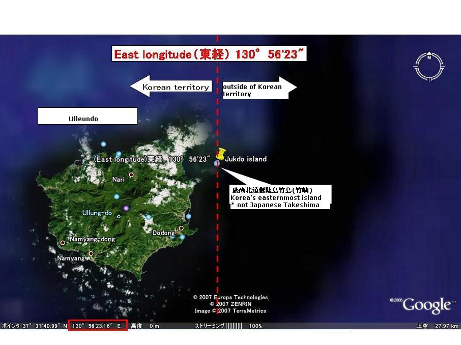
Especially interesting among the books in the list is Choi Nam-seon's (崔南善) 1948 book, "Common Knowledge of Joseon" (朝鮮常識), which specifically says that Korea's easternmost island was Ulleungdo's "Jukdo" in North Gyeongsan Province (慶尚北道鬱陵島竹島). Jukdo is a small island located about two kilometers off Ulleungdo's eastern shore, which matches up with old Korean maps and documents that showed Usando (于山島) to be Korea's eastern most island. Though Koreans claim Usando was Korea's old name for "Dokdo," Korea's old maps and documents show that Usando was actually Ulleungdo's neighboring island of Jukdo, which is at an east longitude of approximately 130º 56' 23." Again, that longitude essentially matches up with longitudes mentioned in the documents below.
As we have seen, many western and Japanese maps around 1900 clearly depicted Takeshima(on-existant Argonaut), which is nearest to peninsula to be Korean, but other islands, "Matsushima(which is actually today's Ulleungdo)" and Takeshima/Liancourt Rocks, to be Japanese territory. It matchs with a fact that so many documents described Korean eastern limit as 130º 35' - 130º 50' which exclude whole or part of Ulleungdo.
1874 "Histoire de L'Eglise de Corée (History of the Korean Catholic Church) by Claude-Charles Dallet
130º 50' E. longitude (東経130度50分)
1876 "Keirinjiryaku(鶏林事略)" by Sewaki Hisato (瀬脇寿人)
130º 35' E. longitude (東経130度35分)
1880 "朝鮮地誌" by 坂根達郎
130º 45' E. longitude (東経130度45分)
1882 "The Joseon Situation" (朝鮮事情) by Enomoto Takeaki(榎本武揚) (Originally published in 1876-77)
130º 50' E. longitude (東経130度50分)
1887 "朝鮮八道誌" by 小松運
130º 35' E. longitude (東経130度35分)
1890 "外国地理" by 高木怡荘
130º E. longitude (東経130度)
1891 "受験応用万国小地誌" by 谷口流鶯
130º E. longitude (東経130度)
1894 "新撰朝鮮地理誌" by 大田才次郎
130º 35' E. longitude (東経130度35分)
1894 "朝鮮志" by 足立栗園
130º 36' E. longitude (東経130度36分)
1894 Jun. "朝鮮地理圖" by 岩崎茂吉
130º 35' E. longitude (東経130度35分)
1894 Jun "朝鮮地誌要略" by 松本仁吉
130º 35' E. longitude (東経130度35分)
1894 Jun. "新撰朝鮮国地図" by 林正
130º 35' E. longitude (東経130度35分)
1894 Nov. "朝鮮水路誌" by Waterway Section of Japanese Navy (海軍水路部)
130º 35' E.longitude (東経130度35分) (序 : 肝付兼行 海軍省水路部長 Preface by Kimotsuki)
1894~1897 "Korea and Her Neighbours" by Isabella Lucy Bird
130º 33' E. longitude (東経130度33分)
1895 "外国地誌" by 秋山四郎
130º 40' E. longitude (東経130度40分)
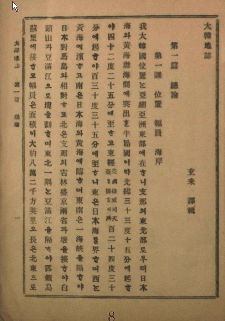
1899 "大韓地誌" by 玄采 (Korean Geography Textbook)
130º 35' E. longitude (東経130度35分)
1899 "新式万国地理" by 岩崎重三
130º 35' E. longitude (東経130度35分)
1900 "新撰大地誌 前編(世界之部)" by 山上万次郎
130º 35' E. longitude (東経130度35分 : 図満江〔註:豆満江) 教師用参考書)
1901 "大韓地誌" by 玄采 (Korean Geography Textbook)
130º 35' E. longitude (東経130度35分)
1901 "朝鮮開化史" by 恒屋盛服
130º 35' E. longitude (東経130度35分)
1902 "高等地理学講義" by 永田健助編
131º E. longitude (東経131度)
1902 "新撰世界地理問答" by 武田鶯塘
130º 40' E. longitude (東経130度40分)
1903 "韓海通漁指針" by 東京 黒龍会 葛生修吉
130º 35' E. longitude (東経130度35分)(序 : 牧朴真 農商務省水産局長 Preface by Maki)
1904 "韓国地理" by 矢津昌永
130º 58' E. longitude (東経130度58分)
1904 "最新韓国実業指針" by 岩永重華
130º 35' E. longitude (東経130度35分)(序 : 山座円次郎 外務省政務局長 Preface by Yamaza)
1904 "朝鮮移住案内" by 山本庫太郎
130º 35' E. longitude (東経130度35分)
1905 "日本民族の新發展場萬韓露領地誌" by 岡部福蔵
130º 35' E. longitude (東経130度35分)
1905 "韓国新地理" by 博文館
130º 58' E. longitude (東経130度58分)
1906 "大韓地誌" by 玄采 (Korean Geography Textbook)
130º 35' E. longitude (東経130度35分)
1906 "韓国水産業調査報告" by 農商務省水産局
130º 35' E. longitude (東経130度35分)
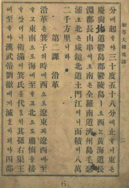
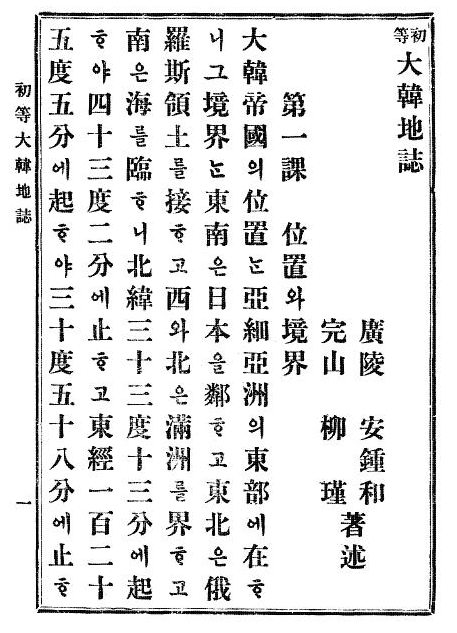
1907 "初等大韓地誌" by 安鍾和 (Korean Geography Textbook)
130º 58' E. longitude (東経130度58分)
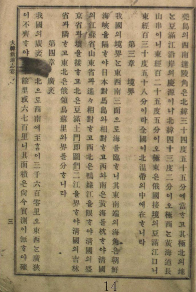
1907 "大韓新地志" by 張志淵 (Korean Geography Textbook)
130º 58' E. longitude (東経130度58分)
1907 "外国地理表解" by 小林杖吉
130º 35' E. longitude (東経130度35分)
1908 "初等大韓地誌" by 安鍾和 柳柳瑾 (Korean Geography Textbook)
130º 58' E. longitude (東経130度58分)
1909 "最新高等大韓地誌" by 鄭寅琥 (Korean Geography Textbook)
130º 35' E. longitude (東経130度35分 慶尚南道鬱島郡鬱陵島 : Ulleundo, Ulleudo County)
1909 "韓国水産誌" by 統監府農商工部水産局
130º 42' E. longitude (東経130度42分)
1909 Mar. "大韓協会会報第12号 地誌" (Korean Geography journal) cache
130º 35' E. longitude (東経130度35分)
1910 Feb. "朝鮮新地誌" by 足立栗園
130º 58' E. longitude (東経130度58分)
1911 "朝鮮及南満洲地理教授備考" by 亀井忠一
130º 54' E. longitude (東経130度54分 極東 鬱陵島東端 : Easternmost of Ulleundo)
1911 "最新日本地理資料" by 井原儀
130º 54' E. longitude (東経130度54分 極東 鬱陵島(松島)の東端 : Easternmost of Ulleundo(=Matsushima))
1911 Apr. "大日本地理集成" by 矢津昌永等
130º 58 E. longitude (東経130度58分 豆門江の江口)
1911 "韓国通覧" by 統監府農商工部
130º 54' E. longitude (東経130度54分 鬱陵島東端 : Easternmost of Ulleundo)
1912 "最近朝鮮事情要覧" by 朝鮮総督府 2版渡辺為蔵
130º 54' E. longitude (東経130度54分)
1912 "小学地理教材" by 北垣恭次郎
130º 54' E. longitude (東経130度54分 鬱陵島の東端 : Easternmost of Ulleundo)
1912 "最新 朝鮮地誌" by 日韓書房編集部
130º 54' E. longitude (東経130度54分 鬱陵島東端 : Easternmost of Ulleundo)
1936 "朝鮮現勢便覧" by 朝鮮総督府
130º 56' 23" E. longitude (東経130度56分23秒)
1947 "朝鮮常識問答" (Qs & As for General Knowledge of Joseon) by 崔南善 (Korean Geography Textbook)
130º 56' 23" E. longitude (東経130度56分23秒 )
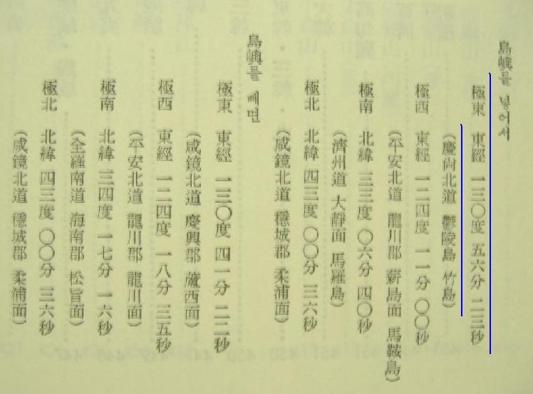
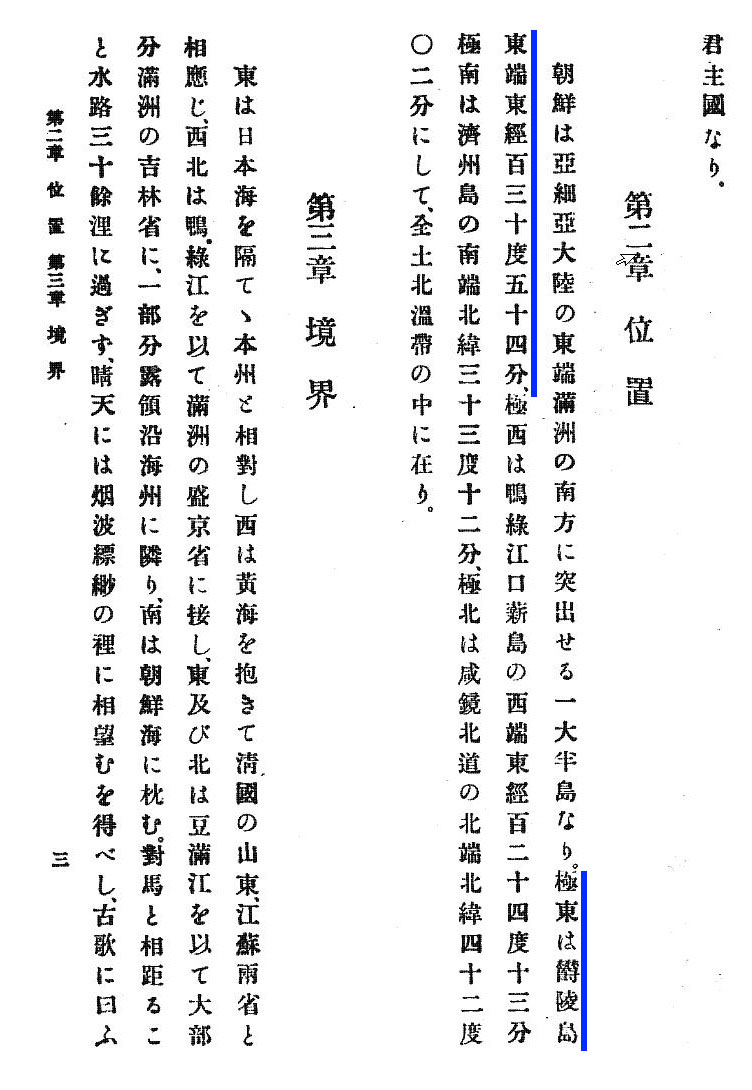
1948 "朝鮮常識" (General Knowledge of Joseon)" by 崔南善 (Korean Geography Textbook)
130º 56' 23" E. longitude (東経130度56分23秒 慶尚北道鬱陵島竹島 : Jukdo of Ulleundo, (*not Japanese Takeshima)
This is a revised version of Korean Eastern limits described in various books exclude Takeshima/Dokdo from Korean Territory, which is a re-revised version of "1894-1948 Korean territory (Revised version)," by Pacifist. As we can see, the oldest document now dates back to 1874 now. The newly added documents are marked red in their published year.
Kaneganese,
ReplyDeleteChoi Nam-seon's book title should be "General Knowledge of Joseon", I think.
Today's Koreans are trying to get away from those evidences because they were written by private people, not by the official government.
Wasn't Choi Nam Seon a pro Japanese supporter?
ReplyDeleteRaquel? You e-mailed me a little while ago saying you were a student from Cincinnati. Please tell us which college you attend, your program and teacher so we can help you!!
Or are you a fake?
Steve Barber,
ReplyDeleteWhat college did you attend, and what was your major? Also, where are you working these days?
You are being obnoxiously arrogant for someone who used to post under five or six different id's until you were discovered.
raquel,
ReplyDeleteThanks for the English title for Cho's book. And I'm really impressed that you know a lot about Takeshima issue. I hope your research in Korea goes well. If there is something I can do for you, please let me know.
As for Cho, he was not only a famous historian, but also a key person for Korean territorial aggression in early 1950s led by president Rhee and his official delegates. If Korean deny his book, it means Korean loses her own basis for her stupid theory. It was Cho who officially started the "Usando is Dokdo" propaganda afterall.
"-韓国が竹島を自国領とした根拠は。 「後の日韓国交正常化交渉の第五次の韓国側代表を務めた兪鎮午によると、著名な歴史学者である崔南善を訪れ、竹島が日韓両国のどちらに属すか、歴史的な根拠を尋ねたという。その結果『確信できる程度の説明』を受けたと言っている」", 発信竹島 ~真の日韓親善に向けて~ : 第3部「過去の清算」-昭和から平成へ-(2)巻き返し, San-in Chuo Shimpo, 2005/09/25. "
"-李承晩ラインを宣言する際、そのお墨付きを求めた韓国政府に対し、歴史学者の崔南善が示した歴史認識とは。「崔は一九五四年夏、ソウル新聞紙上で『鬱陵島と独島』と題し、二十五回にわたる連載を執筆している。そこで展開された説によると、鬱陵島の属島である独島は新羅時代から朝鮮領で、その起源は五一二年にまでさかのぼれるとした。さらに『粛宗実録』(一七二八年刊行)にある『江戸幕府と交渉し、鬱陵島と独島を朝鮮領と認めさせた』という安龍福の証言を基に、現在の独島は韓国領と結論づけている」", 発信竹島 ~真の日韓親善に向けて~ : 第3部「過去の清算」-昭和から平成へ-(5)矛盾, San-in Chuo Shimpo, 2005/09/28."
Kaneganese,
ReplyDeletePerhaps, that's how Choi Nam-seon escaped from being labeled as a "Chinilpa" (Pro-Japanese Group).
It is very unfortunate that Korea was claiming for Tsushima (Daemado) as well without any historical basis for her claim, which only shows how greedy Korea was under the Rhee autocracy.
I strongly suggest that Japan should not let the "thief at a fire" go free. I bet you all know who the "thief at a fire" is. :-)
Kaneganese,
ReplyDeleteThanks for your endeavour, this is quite impressive to anyone who has interest in the Takeshima (Dokdo) issue.
Thanks also to raquel, you are saying that Rhee Syngmann was "火事場泥棒" (a thief who rob anything from a house that is fired). Just exactly!.
The most vicious thing is that the house owner can't stop the thief because he/she has to extinguish the fire first.
Japan couldn't stop the malicious deed by Rhee Syngmann because she was under the control of GHQ (General Headquarters) of allied powers until April 28th 1952 - the day of the Peace Treaty concluded. Rhee Syngmann's line was declared on January 18th that year, apparently Rhee intended to "rob" the island while Japan was occupied by allied powers.
pacifist,
ReplyDeleteAll the evidences show that Korea had not known the Liancourt Rocks
before 1900.
Once, Korea was stating that "Dok" of Dokdo is from the Jeolla-do dialect meaning "Dol" (stone), and now, they are claiming that it is the "Dok" meaning a stone from the Gyeongsang-do dialect.
If Korea was calling the Rocks as "Dokseom" by either Jeolla-do or Gyeongang-do dialect, it makes sense.
However, the difficult task that Korea is having in finding the logical explanation is that "Dokseom" can not become "Dokdo" in any way in their language.
So, we should expect more lies from their desperate attempt to keep the Rocks. :-)
raquel,
ReplyDeleteThanks. I still hope there will be Korean people someday who have logical brain, objective eyes and brave heart to say the truth to all the Korean people.
I think (No.40) 韓国通覧 was published on Apr 1910(Meiji43), not 1911.
ReplyDeleteanother eastern most data;
1910.10 朝鮮新地理 大阪:田中宋栄堂,(
Oct.Meiji43)
東経130”58’E
1907 韓国総攬 徳永勲美 博文館
ReplyDelete130”35’E
1929.
ReplyDelete朝鮮환輿勝覽
130”58E
1903.韓国森林視察復命書
ReplyDelete〔東京〕:農商務省山林局,明36.5
130”35
付属圖
竹島=Argonaut 松島=Ullnuegdo/Dagelet
Cf:
1906.韓国森林調査書〔東京〕:農商務省山林局,〔明39〕
no discription of easternmost boundary
付属圖
松島=Ulleungdo/Dagelet
1910.02韓国南満洲 野口保興著 東京:成美堂,明43.2
ReplyDelete一三〇度三八分なり
一三〇度三五分 朝鮮水路誌
一三〇度三〇分 チャンパー地名辞典
付属圖
鬱陵島(松島)
What is チャンパー地名辞典?
1906.1907世界大地誌 野口保興著 東京:成美堂,明38,39
ReplyDelete130"58'E
1905.世界地理 野口保興講述 早稲田大学三十八年度歴史地理科第一学年講義録
ReplyDelete130"58'E
1907.世界地理 野口保興講述早稲田大学三十九年度歴史地理科第一学年講義録
130"58'E
Thanks, GTOMR
ReplyDeleteI think I need to post the updated one in the near future.
1917.新舊對照朝鮮全道府郡面里洞名稱一覽 越智唯七
ReplyDelete130"54'E 極東鬱陵島東端
1915.大日本帝国地誌 小林房太郞 著 富山房 小林房太郞 著
ReplyDelete富山房
下巻 第一章 位置および面積 (E-book P130)
第一 位置
朝鮮 極東 鬱陵 130度54分 鬱陵島
1907.04.韓国通覧 統監府農商工部 (M43)
ReplyDelete第一 地理 一 位置、境界、面積
東経124度13分(鴨緑江西端)より130度54分(鬱陵島東端)にXき東は日本海に臨み
It's funny the pro-Japanese people try to make readers trust Japanese description of Korean territorial limit. What's the base for deciding the limit of Korean territory?
ReplyDeleteThey are all based on the wrong information or intentional distortion on Korean territorial limit because there is accurate evidence deciding the territory of Korea. The Japanese maps and documents consistently included Dokdo as Korean territory.
Which is more reliable?