Especially interesting among the books in the list is Choi Nam-seon's (崔南善) 1948 book, "Common Knowledge of Joseon" (朝鮮常識), which specifically says that Korea's easternmost island was Ulleungdo's "Jukdo" in North Gyeongsan Province (慶尚北道鬱陵島竹島). Jukdo is a small island located about two kilometers off Ulleungdo's eastern shore, which matches up with old Korean maps and documents that showed Usando (于山島) to be Korea's eastern most island. Though Koreans claim Usando was Korea's old name for "Dokdo," Korea's old maps and documents show that Usando was actually Ulleungdo's neighboring island of Jukdo, which is at an east longitude of approximately 130º 56' 23." Again, that longitude essentially matches up with longitudes mentioned in the documents below. 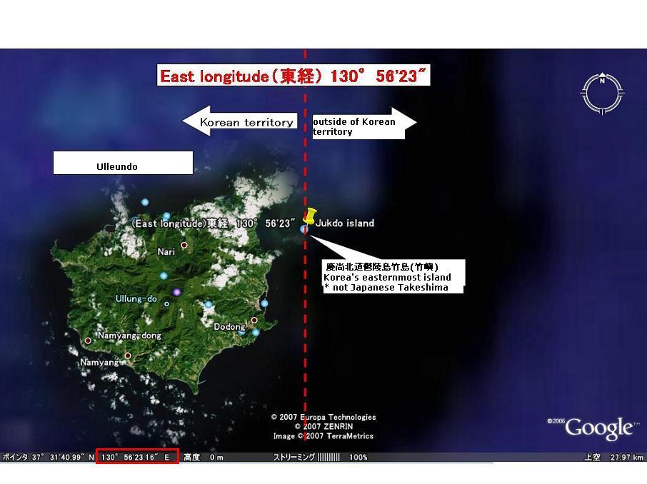 (This is a re-revised version of "1894-1948 Korean territory (Revised version)," which was posted by Pacifist.)
1887 "朝鮮八道誌" by 小松運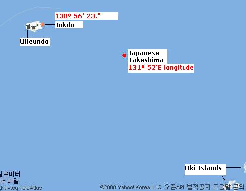 130º 35' E. longitude (東経130度35分)
1890 "外国地理" by 高木怡荘 130º E. longitude (東経130度)
1891 "受験応用万国小地誌" by 谷口流鶯 130º E. longitude (東経130度)
1894 "新撰朝鮮地理誌" by 大田才次郎 130º 35' E. longitude (東経130度35分)
1894 "朝鮮志" by 足立栗園 130º 36' E. longitude (東経130度36分)
1894 Jul. "新撰朝鮮国地図" by 林正 130º 35' E. longitude (東経130度35分)
1894 Nov. "朝鮮水路誌" by Waterway Section of Japanese Navy (海軍水路部) 130º 35' E.longitude (東経130度35分) (序 : 肝付兼行 海軍省水路部長 Preface by Kimotsuki)
1894~1897 "Korea and Her Neighbours" by Isabella Lucy Bird 130º 33' E. longitude (東経130度33分)
1895 "外国地誌" by 秋山四郎 130º 40' E. longitude (東経130度40分)
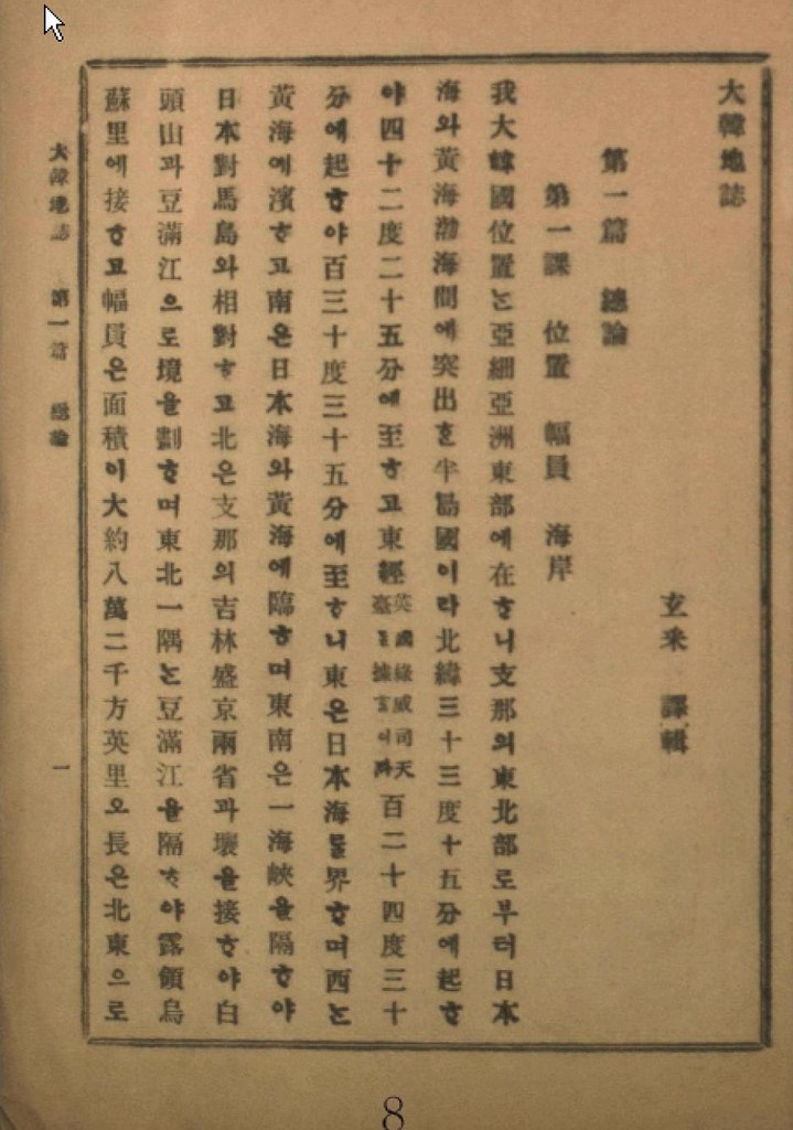
1899 "大韓地誌" by 玄采 (Korean Geography Textbook) 130º 35' E. longitude (東経130度35分)
1899 "新式万国地理" by 岩崎重三 130º 35' E. longitude (東経130度35分)
1900 "新撰大地誌 前編(世界之部)" by 山上万次郎 130º 35' E. longitude (東経130度35分 : 図満江〔註:豆満江) 教師用参考書)
1901 "大韓地誌" by 玄采 (Korean Geography Textbook) 130º 35' E. longitude (東経130度35分)
1901 "朝鮮開化史" by 恒屋盛服 130º 35' E. longitude (東経130度35分)
1902 "高等地理学講義" by 永田健助編 131º E. longitude (東経131度)
1902 "新撰世界地理問答" by 武田鶯塘 130º 40' E. longitude (東経130度40分)
1903 "韓海通漁指針" by 東京 黒龍会 葛生修吉 130º 35' E. longitude (東経130度35分)(序 : 牧朴真 農商務省水産局長 Preface by Maki)
1904 "韓国地理" by 矢津昌永 130º 58' E. longitude (東経130度58分)
1904 "最新韓国実業指針" by 岩永重華 130º 35' E. longitude (東経130度35分)(序 : 山座円次郎 外務省政務局長 Preface by Yamaza)
1904 "朝鮮移住案内" by 山本庫太郎 130º 35' E. longitude (東経130度35分)
1905 "日本民族の新發展場萬韓露領地誌" by 岡部福蔵 130º 35' E. longitude (東経130度35分)
1905 "韓国新地理" by 田淵友彦 130º 58' E. longitude (東経130度58分)
1906 "大韓地誌" by 玄采 (Korean Geography Textbook) 130º 35' E. longitude (東経130度35分)
1906 "韓国水産業調査報告" by 農商務省水産局 130º 35' E. longitude (東経130度35分)
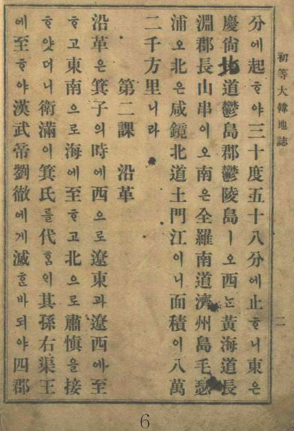
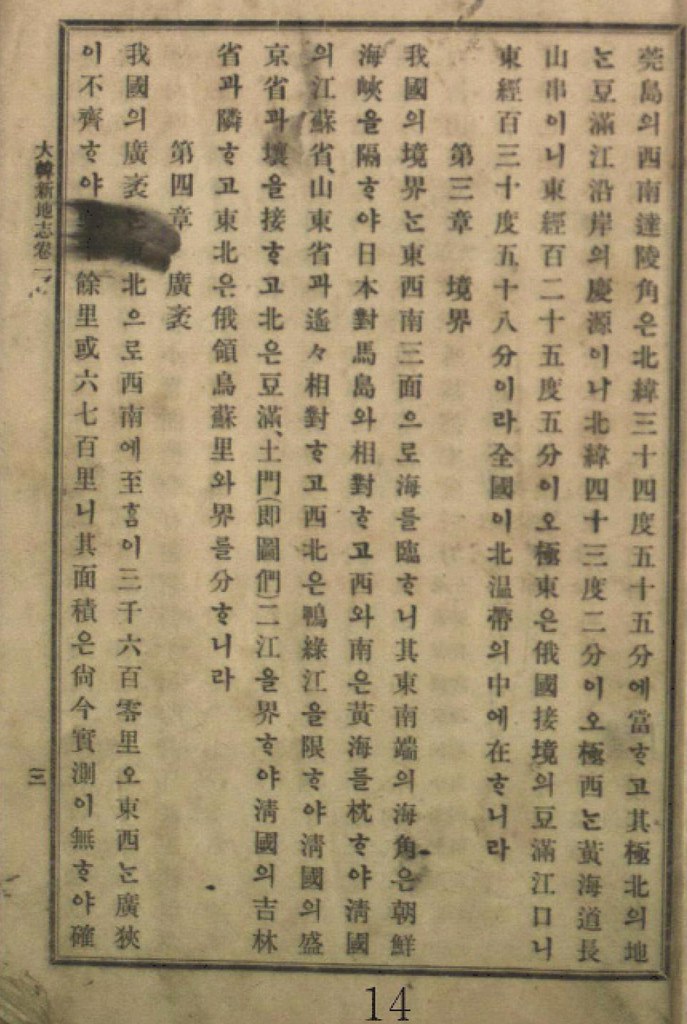
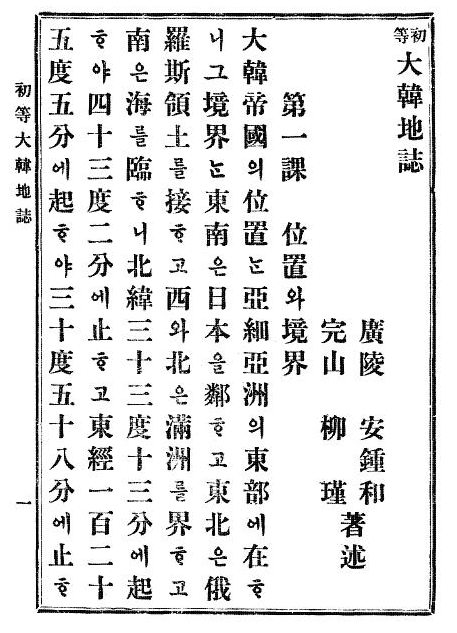
1907 "初等大韓地誌" by 安鍾和 (Korean Geography Textbook) 130º 58' E. longitude (東経130度58分)
1907 "大韓新地志" by 張志淵 (Korean Geography Textbook) 130º 58' E. longitude (東経130度58分)
1907 "外国地理表解" by 小林杖吉 130º 35' E. longitude (東経130度35分)
1908 "初等大韓地誌" by 安鍾和 柳柳瑾 (Korean Geography Textbook) 130º 58' E. longitude (東経130度58分)
1909 "最新高等大韓地誌" by 鄭寅琥 (Korean Geography Textbook) 130º 35' E. longitude (東経130度35分 慶尚南道鬱島郡鬱陵島 : Ulleundo, Ulleudo County)
1909 "韓国水産誌" by 統監府農商工部水産局 130º 42' E. longitude (東経130度42分)
1909 Mar. "大韓協会会報第12号 地誌" (Korean Geography journal) cache 130º 35' E. longitude (東経130度35分)
1910 Feb. "朝鮮新地誌" by 足立栗園 130º 58' E. longitude (東経130度58分)
1911 "朝鮮及南満洲地理教授備考" by 亀井忠一 130º 54' E. longitude (東経130度54分 極東 鬱陵島東端 : Easternmost of Ulleundo)
1911 "最新日本地理資料" by 井原儀 130º 54' E. longitude (東経130度54分 極東 鬱陵島(松島)の東端 : Easternmost of Ulleundo(=Matsushima))
1911 Apr. "大日本地理集成" by 矢津昌永等 130º 58 E. longitude (東経130度58分 豆門江の江口)
1911 "韓国通覧" by 統監府農商工部 130º 54' E. longitude (東経130度54分 鬱陵島東端 : Easternmost of Ulleundo)
1912 "最近朝鮮事情要覧" by 朝鮮総督府 2版渡辺為蔵 130º 54' E. longitude (東経130度54分)
1912 "小学地理教材" by 北垣恭次郎 130º 54' E. longitude (東経130度54分 鬱陵島の東端 : Easternmost of Ulleundo)
1912 "最新 朝鮮地誌" by 日韓書房編集部 130º 54' E. longitude (東経130度54分 鬱陵島東端 : Easternmost of Ulleundo)
1936 "朝鮮現勢便覧" by 朝鮮総督府 130º 56' 23" E. longitude (東経130度56分23秒)
1947 "朝鮮常識問答" (Qs& As about common sense of Chosun) by 崔南善 (Korean Geography Textbook) 130º 56' 23" E. longitude (東経130度56分23秒 )
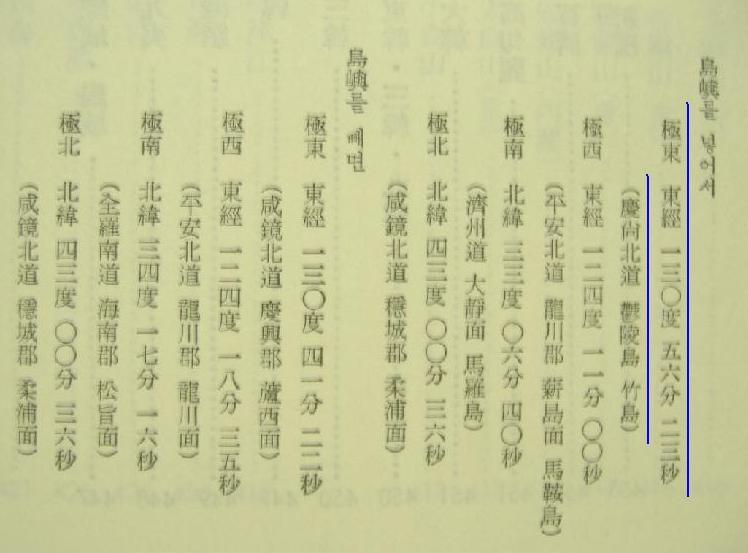
1948 "朝鮮常識" (Common sense of Chosun)" by 崔南善 (Korean Geography Textbook) 130º 56' 23" E. longitude (東経130度56分23秒 慶尚北道鬱陵島竹島 : Jukdo of Ulleundo, (*not Japanese Takeshima)
Lots of thanks, Kaneganese!
ReplyDeleteThis list is the concrete evidence to show that Korea never had Liancourt rocks before Japan incorporated it into Shimane prefecture and to show that Liancourt rocks belong to Japan. It also proves that the occupation by Korea is illegal.
Kaneganese, all documents or maps that show Korea's limit as anything other than 130.55 are useless to prove your point. We know Ulleungdo was always considered to be part of Chosun yet about almost all of the documents you cite exclude Ulleungdo as Korean land. These documents either excluded outlying islands and deemed the Northern tip of Korea as the limit or were simply inaccurate. They also could have used Seibolds positioning of the islands such as was the case in many documents and maps of this era.
ReplyDeleteOf course post 1905 documents of this era don't show Liancourt Rocks as part of Chosun Japan's military seized the island during the Russo~Japanese War in 1904~1905.
Thank you, pacifist.
ReplyDeleteAnd many thanks to everyone who helped me as always.
Collecting and listing chronologically those documents tells us a lot. It looks like it had been common sence among Japan, western countries and Korea that its eastern limit is between 130º 35' E. longitude (豆満江) to 130º 56' 23" E. longitude(Jukdo), apparently excluding Takeshima/Dokdo.
The most important of all, addition to 1948 "朝鮮常識"'s definition that Jukdo is the easternmost of Korea, not Takeshima/Dokdo, is even many Korean official books clearly defined Takeshima/Dokdo as outside her territory. And secondly, Kimotsuki, Yamaza and Maki were highly possibly knew this fact when they were consulted by Nakai to incorporate the island into Shimane in 1905.
By the way, Mr. Sugino Yomei uploaded the 毎日申報 article on 1913年6月22日 here. Gerry already talked about this article on occidentalism , but it looks like there were more sentences in the article.
Kaneganese,
ReplyDeleteI have posted the 1913 Korean article to the blog, and transcripted what I could read from it.
Yes, there were more sentences in the article, but it does not really give much more information.
シャルル・ダレ『朝鮮教会史』(1874)
ReplyDeleteClaude Charles Dallet ; “Histoire de L'Eglise de Corée”
・・・・・・・・・・・・・・・・・・・・・・・・・・・・・・・・
昔から良く知られている史料に、フランス人シャルル・ダレ(Claude Charles Dallet)の『朝鮮教会史』Histoire de L'Eglise de Corée(1874年 パリ刊)があります。
この第一章「朝鮮の自然地理」に、朝鮮王国の範囲として
北緯33度15分から42度25分のあいだ、
東経122度15分から128度30分のあいだとあります。
(フランス語原文)
entre 33°15’ et 42° 25’ de latitude nord ;
122° 15’ et 128°40’ de longitude est de Paris.
この東経128度30分は「グリニッジ基準」ではなく、「パリ基準」です。
よって、これにパリの東経2度20分を足すと、東端は東経130度50分となります。すなわち、131度52分の竹島=独島は除外されています。
また、この本には地図がついていますが、著者自身によって、次のように説明されています。
「本書の巻頭に掲げた地図は、沿岸地域に関しては海軍保管の地図によって作成し、内陸部については、現地人の比較的最近の地図を駐朝鮮教区助任司祭リデル神父の翻訳したものに拠って作成したものである。」
(訳本:平凡社東洋文庫367『朝鮮事情』 金容権訳16~17p)
Celle que nous donnons en tete de cet ouvrage a ete dresse, pour le littoral, d’apres une carte du depot de la marine, et pour l’interieur du pays, d’ après une carte indigene assez recentre, tranduire par Mgr Ridel, vicaire apostolique de Coree.
この地図を見ると、鬱陵島をOul- leng -toとし、その東南に小さな島を書いてOu-sanとあります。そして、2つの島全体にかかるように、Dageletと書かれています。
韓国側は、このOu san于山が、独島=竹島であると主張していますが、少なくともこの地図のOu sanは、Dageletの一部であり、リアンクールでないことは明らかです。
ちなみに、リアンクール岩はこの地図には書かれていません。
リアンクール岩は、フランスの捕鯨船によって1849年に発見されていますから、フランス海軍は、その情報を緯度・経度を含めて、知っていたと思われます。「フランス海軍保管の地図」を参照した著者は、リアンクール島についての情報を知ったうえで「朝鮮王国」の版図から、はずしていることになります。
ただし、この地図を良く見ると、豆満江河口のほうが、鬱陵島・于山(Dagelet)
より東側にあり、地図で見ると、128度30分とはここの経度を指すように読み取れます。すなわち、この本の著者は朝鮮王国の東端は豆満江河口と考えていたようです。
(了)
初めて、投稿しました。
『朝鮮教会史』原本は、国会図書館にも所蔵があり、地図もコピー可能です。
また、イ・サンテLee Sang Tae氏も、『資料が証明する独島は韓国領』(2007)
“Historical Evidence of Korean sovereignty over Dokto”にこの地図を載せています。(146p)
図像をアップする方法を知りませんので、どなたか地図、およびフランス語本文の印影をアップしていただけると幸いです。
『鶏林事略』 明治9年4月(1876) 瀬脇寿人(せわき・ひさと)
ReplyDelete林深造(はやし・しんぞう)
題字 木戸孝允
序 咸鏡道慶興府人 金麟昇
緯線は、赤道の北三十四度十七分より起り、四十三度二分に至て止み、
経線は、英国「グリインウヰッチ」の偏東百二十四度三十分より起り、百三十度三十五分に至て止む。
すなわち、北緯34度17分~43度02分、東経124度30分~130度35分
これは、『朝鮮水路誌』の東経124度30分~130度35分と、まったく同じです。
この「東経130度35分」説をさかのぼるものとしては、小松運の『朝鮮八道誌』があげられていますが、さらにさかのぼるもの、としてこの書があります。
「~より起り、~に至て止み、~より起り、~に至て止む」という文体も、このあとここにあげられた諸本に引き継がれて行きます。
この「東経130度35分」説には、その根拠となった共通の「洋書」があるのではないかと思われますが、それが何であるか、まだ不明です。
瀬脇寿人(せわき・ひさと)(1828~1878)は、元の名前を手塚律蔵といい、幕末時代からの蘭学者です。日本政府のウラジオストック貿易官だった人ですが、「松島開拓願い」を出した人であり、鬱陵島=松島は日本領と思っていたとも思われます。そのせいか、この本の「島嶼」の項目には、鬱陵島の説明がありません。
matsuさん
ReplyDelete貴重な情報を有難うございます。
“韓国カトリック教会の歴史(Histoire de l’Eglise de Coree)” (1874)は、Gerryがこちらで(5番目) 地図を掲載しています。おそらくイ・サンテ氏の本からとったものと思われます。
東端については豆満江河口とするものと鬱陵島東端(もしくは竹嶼)とするものと2パターンあるようです。公民関わらず出来るだけ多くの資料を集めてこうして列記する事によって様々な事が分かってくると思います。
瀬脇寿人ですか!! これはこれは。しかも、明治9年とは、驚きです。松島開拓の議の一連の動きと合わせて考えるとより当時の事情がわかりそうですね。
”この「東経130度35分」説には、その根拠となった共通の「洋書」があるのではないかと思われますが、それが何であるか、まだ不明です。”
そう。これが最大の疑問です。最初は China Sea Directory 3rd Edition, Vol 4.(1894)だと思っていたのですが、原本を確認したところ、記述がありませんでした。 Isabella Lucy Birdが東経130度33分している所を見ると、ひょっとして日本が独自に測量していたのかもしれません。肝付について調べていたところ(こちら)、明治5年には独自の測量地図を作製しています。推測に過ぎませんが。とにかく、もっと洋書を調べたいな、と思っていますが、なかなか機会がありません。
ところで、これらの本の原文画像、お持ちでしたら、私に直接メールでお送りいただくか、どこかにアップロードしたものをURLを教えていただければ、こちらでリンクするようにします。それからリストに追加させていただきたいと思っています。
また何かありましたら是非こちらに情報をお寄せ下さい。コメント大歓迎です。日本語でかまいません。よろしくお願い致します。
The Full Map of Chosun(朝鮮国全図) by 瀬脇寿人with 金麟昇 here,
ReplyDeletehttp://dokdo-or-takeshima.blogspot.com/2007/11/japanese-map-of-korea.html
Kaisan-tou亐山島,considered as Usando干山島, in the west of Ulleungdo
I heard 金麟昇 is so-called hired-foreigner(お雇い外国人 of Meiji-Govt)
So 金麟昇 he don't know about Lianocurt Rocks.
kaneganeseさん、gtomrさん
ReplyDeleteありがとうございます。
“Histoire de L'Eglise de Corée”も、
『鶏林事略』も、国会図書館でコピーをとったのですが、紙で持っているだけで、ネットにアップする手立てを知りません。
すみません。
後者はまだ近代ライブラリーにものっていないようです。
金麟昇については、確かに、日本の明治政府の「お雇い外国人」だったという説を何かの論文で読んだことがあります。
金麟昇は、咸鏡道の地方役人だった人がロシアに逃亡して、ウラジオストック近くの村で子供たちを教えていたというような「儒教的教養人」だったようで、そんな人が、当時、リアンクールのことを知らなかったからといってせめるのも、ちょっと可哀想なような気もします。
matsuさん
ReplyDelete情報ありがとうございます。時間を見つけて私が国会図書館に出向くことにします。
GTOMRさんは“金麟昇は朝鮮人ではなくお雇い外国人だった(はずな)ので、リアンクールの事を知らないの(は当然)だ”と言う趣旨のご発言だと思います。英語でやり取りしていると、このように齟齬を生じることが多いのです。
1880.07.朝鮮地誌 坂根達郎
ReplyDelete西経は我が東京より九度に発し、十二度に終る。江原道 特に記載無し。
1893. 新体地理全誌 永田健助著
北緯三十四度十七分に起り四十三度二分にき(カンウォン道豆満江)東経百二十四度三十分より1百三十二度三十五分の間にXXし其境界東は日本海に瀕し
1894.06朝鮮地理圖 東京:岩崎茂吉,明27.6
百二十四度度三十分に起り百三十度三十五分に至る
1894.07.朝鮮地誌要略 松本仁吉 明治27.6
東経124度より同130度に達す
(Attached map show argonaut-Takeshima and Dagelet-Matsushima-Ulluegdo)
This comment has been removed by the author.
ReplyDeleteKaneganese,
ReplyDeleteYour link Ulleundo's "Jukdo" in North Gyeonsan Providance - Where and when was this published?
Kaneganese,
ReplyDeleteYour link "Ulleundo's "Jukdo" in North Gyeonsan Providance" - Where and when was this published?
I'm not sure why I'm not gettting any response because the source is unknown or fabricated?????
ReplyDeleteBolg masters (Kaneganese, gerry, & pacifist)
ReplyDeleteYou had links to what you claimed to be Korean document indicating Korean territory is limited 130deg 56min 23 sec, is replaced by bogus graphic. What happened to this document? It is now replaced by computer graphic of Ullungdo with Jukdo moving... The document I'm looking for is http://farm4.static.com/3092/2380876770_b47fl6c677_o.jpg. It now says Photo is unableable.
You still have link "Ulleungdo's "Jukdo" in North Gyeongsan Province (慶尚北道鬱陵島竹島)", but this is different from yesterday, what happened to picture of your claim of Choi Nam Seon's 1948 book?
Dennis,
ReplyDeletehttp://farm4.static.flickr.com/3092/2380876770_b47f16c677_o.jpg
I can see the document on 1948 above...Check your internet setting or firewall and so on.
I analyzed the longitudes of Dokdo described in the books mentioned above to see if they are really meaningful. The result is they aren't.
ReplyDeleteThe longitudes of those books as Korean eastern boundary can be classified into 5 categories.
Category 1. Longitudes from books published after Japanese annexation of Korea in 1910
Category 2. Longitudes from books wrongly excluding even Ulleongdo within Korean land (The longitude of Ulleongdo is 130〬 53’E.)
Category 3. Longitudes from Korean geography books after Korean liberation from Japan
Category 4. Longitudes from geography books of Korea written by Korean authors
Category 5. Longitudes from geography books of Korea written by Japanese authors including Ulleongdo but excluding Dokdo as Korean land
The longitudes from category 1 and 2 are not meaningful at all.
Most longitudes from above-mentioned books are included in category 2.
The longitude of Korean eastern limit of "朝鮮常識問答" and "朝鮮常識" in category 3 is not meaningful, either. Even though those two geography books were published after 1945, their original version was written during Japanese colonial period and the author Choi Nam-sun is notorious for his pro-Japanese activities during Japanese colonial period. His statement as a pro-Japanese collaborator is not meaningful at all in Dokdo issue. For your reference, Choi Nam-sun’s description was a copy from “朝鮮現勢便覧" by the Japanese Office of the Governors-General of Korea(朝鮮総督府).
(Continued)
ReplyDeleteThe longitudes of Korean eastern boundary from the category 4 are also not meaningful for the following reasons.
1. Hyun Chae, the author of "大韓地誌", wrote in the epilogue that he referenced Japanese geography books. It means he unknowingly copied the wrong description of Korean eastern limit of Japanese geography books. 130〬 35’ E. longitude doesn't include even Ulleongdo, which means it's just incorrect.
2. Jang Ji-yeon who wrote "大韓新地志" also referenced "New Geography of Korea(韓国新地理)" by Tabuchi Tomohiko which described the Korean eastern limit as 130〬 58’ E. longitude. This longitude includes Ulleongdo but excludes Dokdo. Then, it would be important to confirm if Tabuchi Tomohiko was sure Dokdo was not within Korean territory. The answer is "No". He gave an explanation on Dokdo(ヤンコ島) under the section of Ulleongdo of Gwangwon Province, which means he clearly understood Dokdo was Korean land. There's also a map of Korea attached to "韓国新地理" including Dokdo within Korean territory. Even though Jang copied wrong longitude of Korean eastern boundary, he clearly showed his recognition of Dokdo as Korean land by writing "Usando(Dokdo) exists to the south-east of the island(Ullogndo)." after explaining about Ulleungdo under the section of North Gyeongsang Province.
For the image of original text of "韓国新地理", click HERE
For the map of Korea attached to "韓国新地理", click HERE
Two books are left in category 5. They are "高等地理学講義(1902)" and "韓国地理(1904)" which include Ulleogndo but exclude Dokdo as Korean land. I have no idea how they defined Korean eastern limit. If anyone knows, please let me know.
It is not too much to say that the descriptions of Korean eastern limit by above-mentioned books are meaningless and useless.
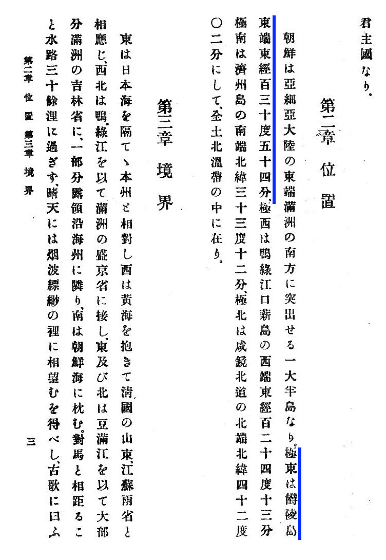
Instead, there is very significant geography book written by Japanese scholar after Japanese incorporation of Dokdo(1905) defining the eastern limit of Korea. In 1930, a Hibatakke Sekko(桶畑雪湖) wrote an article "Regarding the relation of Japan&Chosun on Takeshima(Dokdo) in the Sea of Japan (日本海にある竹島の日鮮関係について)". In the article included in "Historical Geography (歷史地理)", the author stated:
“Takeshima and Ulleungdo are currently Korean land belonging to Gangwon Province of Korea, and they constitute the eastern limit of Korea.(竹島と鬱陵島はいま朝鮮江原道に属する朝鮮の領土であり日本海の最東端に属している”
The conclusion is simple. The longitudes of Korean eastern boundary in above-mentioned books are just meaningless. Thus,the pro-Japanese people should stop misleading the readers with those wrong information.