竹島問題の歴史

20.4.08

1900 - "Uldo-gi" (鬱島記), by U Yong-jeong (禹用鼎)

The following scan is supposedly the first two pages of U Yong-jeong's (禹用鼎) "Uldo-gi" (鬱島記), which was written in 1900. The document is supposedly stored in the National Institute of Korean History (國史編纂委員會 - 국사편찬위원회), though the document does not appear in a search of the institute's database.

A transcription of the document is shown below, though I am unsure if it is a full transcription since a longer, more detailed version of the "Uldo-gi" is stored in the Koryo University Library. I cannot explain why the transcription below is shorter and different from the Koryo University Library version, which seems to have an addendum that makes it, at least, three pages longer.


鬱島記

鬱島 古稱于山國 未知羅朝何代之建國 而文獻無徵亦不可考 至智證王 亂徒窃據恃險不服 命帥臣異斯夫 船載木獅子 往于山紿之曰 ‘爾若不服 多放此獸噬殺爾輩於是.’ 國人大惧而乃降云. 此乃野史之所傳而亦無國乘所載 自此以後空廢其地 幾百年而史無傳焉. 至我朝 龍蛇之變 三陟鄭氏幾人避兵於此

肅廟朝 搜出金丸等七十餘人 載於史冊 而此後 命三陟副使 越松萬戶 間三年搜討 使之不得居生 蓋慮絶島中若有無賴 成群或作禍胎也.

粵在皇上 踐祚聖德巍蕩遐通 一體率土之濱莫非王民 頃於壬午 命帥臣李奎遠爲開拓使 在前潛渡日人一千五百餘名 盡爲撤歸後 關東人七八家先入 而嶺南人十餘家 隨入倚巖 爲屋放火菑田 自此以後 八路之人 稍稍移來 漸成村落 然而鼠灾甚酷 田穀無遺 其時島長徐敬秀 告狀政府 領議政沈舜澤 筵奏劃下 三陟蔚珍平海三邑 還穀中三百石 以賑島民 自是以後 生齒日蕃 土地漸闢 儼成一都會 然挽近日人 浸浸潛越 侵虐居民亂斫木料 島監裵季周 自丙申到任以後 禁止不得 屢度報告 內部大臣李建夏 深慮弊源 上年九月 以本部視察官 爲調査委員 使之前往詳察該島情形之意 上奏裁可 而余以不才猥承此 命又與日本公使 會辦外部 迺於本年五月卄五日 發向仁港. 越七日 與日本警部補渡邊鷹治郞 搭乘木曾川丸 直向釜山港. 卄九日 午後 到泊會同 監理署主事金冕秀 海關稅務士法人羅保得 同幫辦金聲遠 日本副領事赤塚正輔 同警部渡邊鷹治郞 我國保護巡檢申泰炫 金亨郁 日本保護巡檢二人 共搭本國蒼龍丸. 三十日 發向鬱島 越翌日 上午八点 遠見本島 峯巒羅列 而雲靄矇籠 至下午一時 始泊道洞浦口 此是本島監私室處也. 其翌日 卽六月一日 與日領事 會同調査 稅務司則在傍參聽一連. 三日 査問日人與島監而所供相反 盖日人則本是潛越犯法 一直飾辭 發明所致更無可査問. 翌日 會同更搭輪船 巡察全島 而住輪下陸 則天府洞之古仙浦 玄圃洞 台霞洞 三洞 而台霞洞洞壑圓開 地勢平鋪 有官舍八間 赤有前人題銘 依舊例致誠于山神堂 曉諭洞民 而日已沉西 故悤悤還島. 五日 各洞民人等狀禀目告訴 還至左酬右應少無間隙且 輪船不可多日留泊 石炭亦告乏 島中民雖欲挽留 事機無奈.

越六日 上午十時 草草勘簿 仍搭輪船回棹 則本島山川形勝土産風俗 雖未可詳知 然留連五日 公事之暇 召入各洞父老 詳論開拓以後事實 間亦有異聞. 槩全島長可爲七十里 廣可爲四十里 周廻亦可爲一百四五十里 而自壬癸開拓以後 至今居民爲四百餘家 男女共爲一千七百口 起墾火田爲七千七百餘斗落 而厥土沃 腴播穀豊 登所種則大小麥黃豆甘藷 家家足粮水利 則採藿爲主至於綿花麻布紙屬等物 不待外至而自足 若或値災年 則幸有鶴鳥與茗夷草 可免飢餓 此是上天好生之德 若有意 而生此物於此土耶. 鶴鳥則鷹喙 而鳧足毛皜而鳩 大晝則翶翔乎海面 啄食魚種 暮則歸於山間而穴處 人欲捕得用火山中 則向明來集 因以捕獲全不費力 味如鳧肉 而尤佳茗夷 則一莖兩葉 莖如蒜穗 而葉如玉簪 其花如葱穗之種 而味亦如之 盖以此禽此草 經年喫過 亦無飢荒之色 甚異事也. 山勢則層巒聳翠 奇巖怪石 或如人立或似獸 遵千態萬象 雖以描寫 而樹木參天 有槻木․紫檀․栢子․甘湯等木 無非堅密 紋緻可供珍皿也 尤有異焉者 峯壑若是深邃 而無虎豺蛇虺之害 樹木若是茂盛 而亦無荊棘剌膚之 若莫非靈氣所鍾除祛 害人之物也. 島人之稱小金剛宜也 非虛譽也 所恨者 奉命來此公事煩劇 不得對此名勝 一敘幽懷 而此生亦不可再見 甚可歎惜 而亦見笑於山靈也.

巡島日謾吟一絶

海中鬱島久聞名 挺立奇峯不世情 鍾得千年淸淑氣 山無虎蛇樹無荊

13.4.08

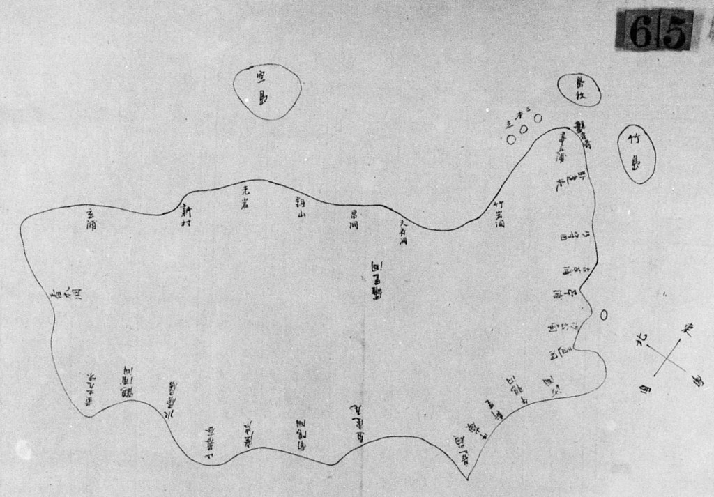
1900 Japanese map of Ulleungdo

I have posted this map for discussion purposes and will add to this post later.

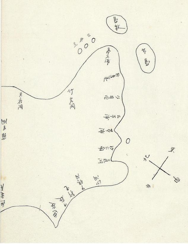
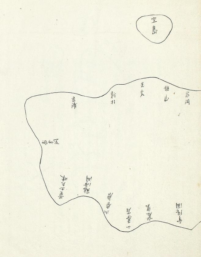
Below is the copy of the above map that was sent to the Japanese Ministry of Foreign Affairs. Notice that the placenames were written somewhat more clearly.


11.4.08

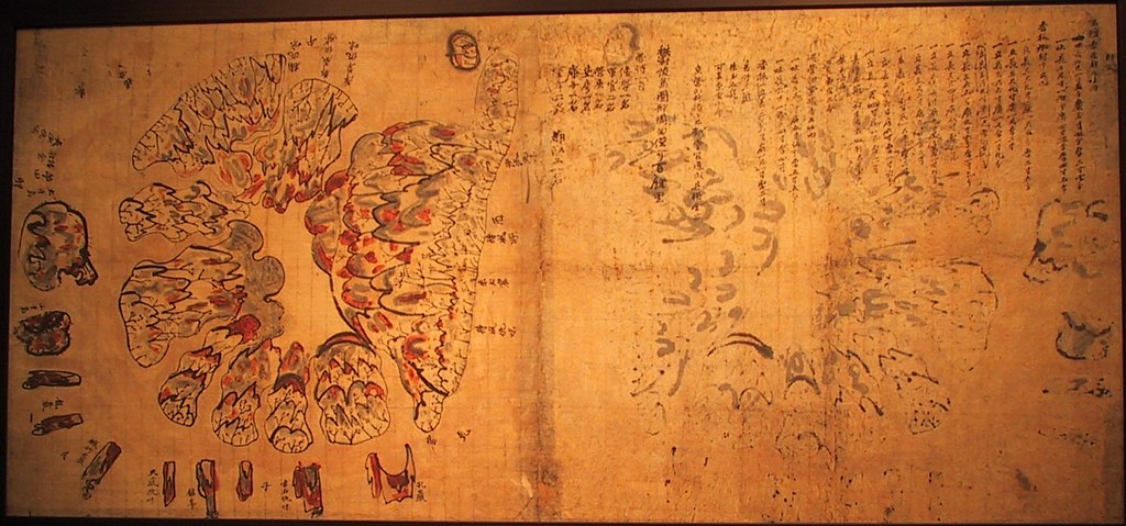
19th c. Map of Ulleungdo: "Ulleungdo Dohyeong" (鬱陵島圖形), property of Samcheok Museum

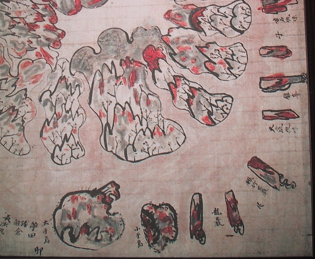
Below is an old Korean map of Ulleungdo called the "Ulleungdo Dohyeong" (鬱陵島 圖形), which is believed to have been made sometime in the 19th century. The map is significant because it is one of the first Korean maps to show Ulleungdo's neighboring island of Gwaneumdo (觀音島), which was labeled as 小于島 (Small Udo). Previous maps had typically shown Ulleungdo with only one neighboring island called "Usando" (于山島), which is labeled on this map as 大于島 (Big Udo). The map is displayed in the Samcheok Municipal Museum (三陟市立博物館), which is a small but nice museum. ENLARGED MAP LINK


Interesting Characteristics of the Map

One interesting characteristic of the map is that Ulleungdo was drawn upside down, which means that the north side of the island appears at the bottom of the map. Another interesting characteristic is that the map was one of the first Korean maps to use the word "gumi" (仇味) as part of some of the placenames on the island. "Gumi" was the Korean word for "cove." The map is also the only old Korean map to have listed the products that Ulleungdo inspectors brought back from the island. However, probably the most interesting characteristic of the map is that it was one of the first Korean maps to show Ulleungdo's neighboring island of Gwaneumdo (觀音島), which is only about 100 meters on Ulleungdo's northeast shore and is Ulleungdo's second largest neighboring island.

Prior to the above map, old Korean maps typically showed Ulleungdo with only one neighboring island, which was called "Usando" (于山島). Koreans claim that Usando was the old Korean name for Liancourt Rocks (Dokdo/Takeshima), but old Korean maps and documents show that Usando was almost certainly Ulleungdo's neighboring island of Jukdo (竹島), which is about two kilometers off of Ulleungdo's east shore and is Ulleungdo's largest neighboring island. Prior to this map, Koreans may have considered Gwaneumdo more of a cape than an island since it was so close to the shore of the main island.

Some Theories on the Names "Big Udo" & "Small Udo"
On the map, Jukdo and Gwaneumdo were labeled as "Big Udo" (大于島) and "Small Udo" (小于島), respectively, which suggests that the mapmaker was unsure of which of the two islands was the "Usando" that had appeared on earlier maps. Notice that the 山 character was dropped from the names. I think a possible reason for that was that Koreans may have preferred 3-character names for islands rather than 4-character, possibly for superstitious reasons, or maybe it was written just as a shorthand. Also, the following may be another reason for the names:
I think 于島 (Udo) was a misspelling of 干島 (Gando - Shield Island), which is another way of saying "Bangpaedo" (防牌島). Bangpaedo also means "Shield Island" in Korean. A 1786 Ulleungdo Inspection report said that Bangpaedo was "east of Hujukam (帿竹巖) and three ri (1.2 kilometers) offshore," which suggests that Bangpaedo was Ulleungdo's neighboring island of Jukdo (竹島). Then in a 1794 inspection report, Bangbaedo was reported to be north of Jukdo (竹島), which suggests that Bangbaedo was Gwaneumdo (觀音島). Therefore, Ulleungdo inspectors after 1794 may have seen both the 1786 and 1794 reports and been confused about which of the two islands was actually Bangpaedo, which prompted them to come up with the names "Big Shield Island" (大干島) and "Small Shield Island" (小干島). HERE is another Inspector's map of Ulleungdo, quite similar to the map above, that actually uses the labels 大干島 and 小干島."

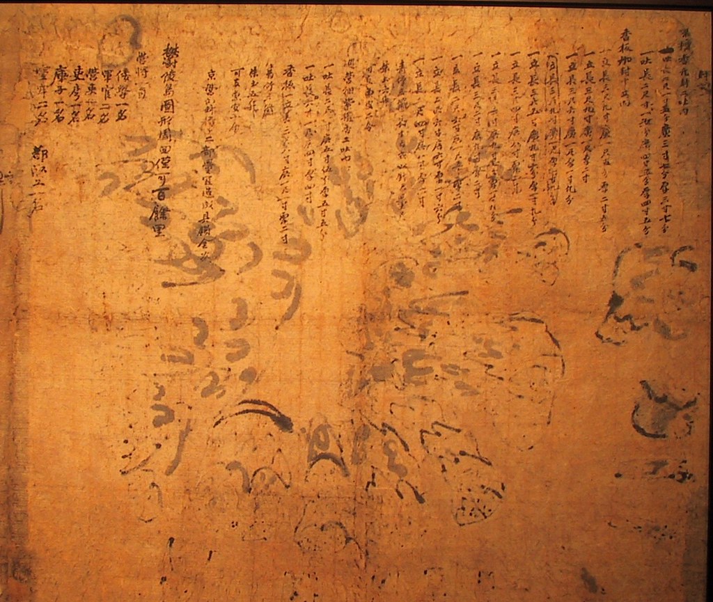
The following is a list of the placenames on the map, their modern equivalents, and other placenames used in the past. Also. included is a list of the island products brought back by the inspectors and the titles and number of people in the inspection party.

Offshore Rocks & Islets

  • 大于島 (대우도 - Big Udo) --> Jukdo (竹島); Usando (于山島)
    Notice that caves or hollows seem to be drawn on the side of the island facing away from the main island.
    .
  • 小于島 (소우도 - Small Udo) --> Gwaneumdo (觀音島); Dohang (島項 - Island Neck)
    Notice that two caves or hollows seem to be drawn on one side of the island.
    .
  • 龍巖 (용암 - Dragon Rock) --> Samseon Rock (三仙巖); Brothers Rock (兄弟巖)
    Notice that Dragon Rock is actually two rocks..
  • 帿竹巖 (후죽암 - Hujuk Rock) --> Jukam (竹巖 - Bamboo Rock)
    In an 1886 survey of Ulleungdo, Hujuk Rock and Jukam were different rocks, but Jukam was said to look like Hujuk Rock.
    .
  • 孔巖 (공암) --> Elephant Rock (코끼리 바위)
    Looks like an elephant with its trunk in the water(Some of the rocks drawn offshore were actually places onshore, probably drawn offshore to give them shape.)
Island Coves & Landmarks

  • 長沙仇味 (장사구미 - Long Sand Cove) --> Sadong (沙洞 - Sand Village)
    A 1902 Japanese report on Ulleungdo described Sadong as being the only beach on Ulleungdo with a sandy bottom..
  • 倭船倉 (왜선창) - Japanese Boat House) --> Near Sadong (沙洞) or maybe Dodong (道洞)
    .
  • 苧田 (저전 - Ramie Field) --> Was possibly present-day Jeodong (苧洞)
    .
  • 天底仇味 (천저구미)
    .
  • 錐峯 (추봉 - Spike Peak) --> Jubong (錐峯)
    .
  • 玄石仇味 (현석구미 - Black Rock Cove)
    .
  • 待風仇味 (대풍구미 - Wind-waiting Cove)
    .
  • 朱土窟 (주토굴 - Red Earth Cave)
    .
  • 待風* (대풍* - Wind-waiting *)
    .
  • 沙汰仇味 (사태구미 - Landslide Cove)
    .
  • 萍草仇味 (평초구미 - Duckweed Cove)
    .
  • 都藏仇味 (도장구미 - Dojang Cove)
    .
  • 桶仇味 (통구미 - Barrel Cove)
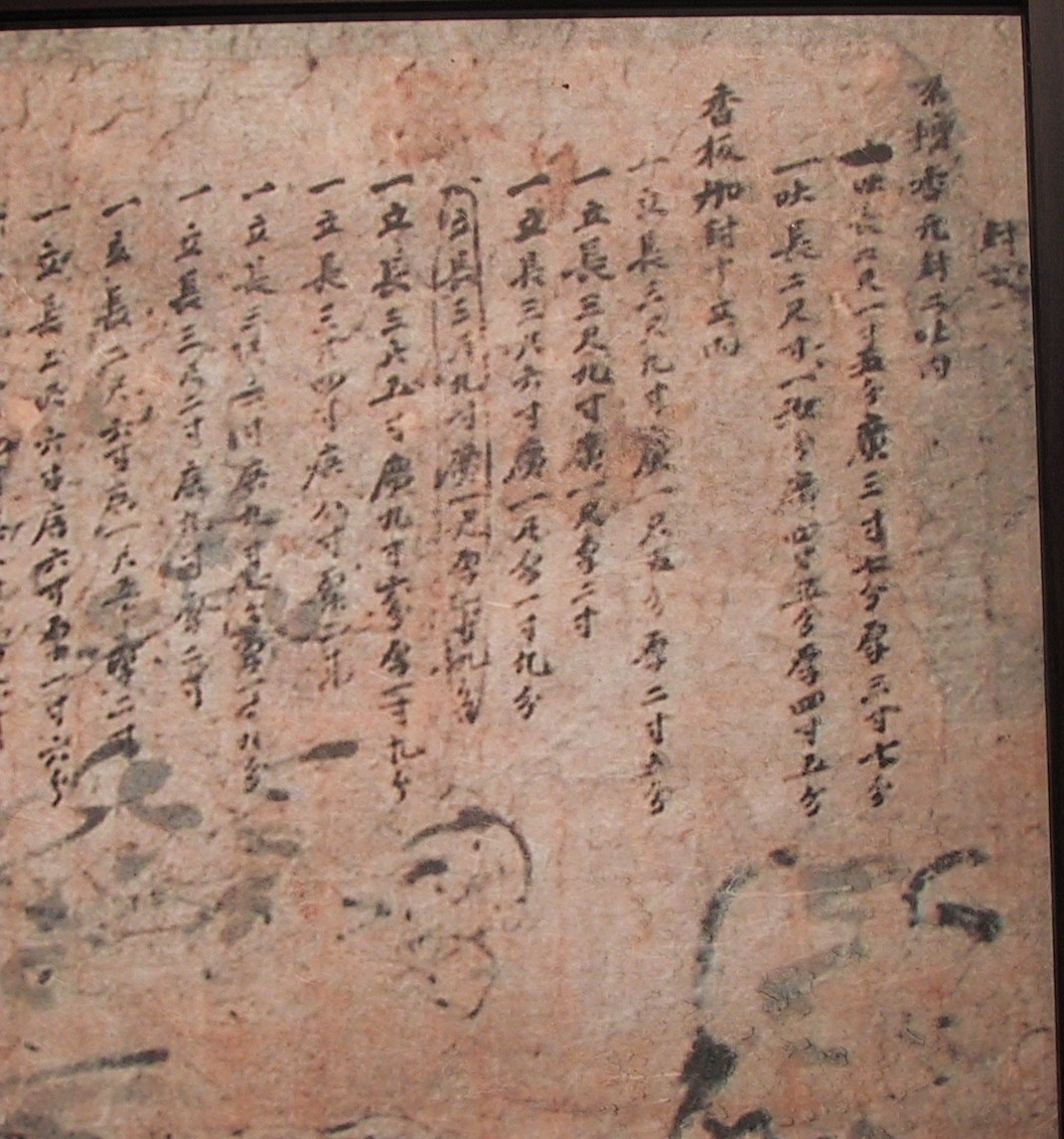
Products Brought Back from Ulleungdo
封 *
名壇香元封ニ吐內2 Sticks of Myeongdanhyang (rosewood incense) Enclosed
  • 一吐 長六尺一寸五分 廣三寸七分 厚三寸七分
    1 stick: length 6 jeok, 5 bun; width 3 chon, 7 bun; thickness 3 chon, 7 bun
    .
  • 一吐 長二尺寸一*分 廣四寸五分 厚四寸五分
    1 stick: length 2 jeok, 1 * bun; width 4 chon, 5 bun; thickness 4 chon 5 bun
香板加封十立內10 Strips of Juniper Enclosed
  • 一立 長三尺九寸 廣一尺*分 厚二寸*分
    1 strip: length 3 cheok, 9 chon; width 1 cheok, * bun; thickness 2 chon, * bun
    .
  • 一立 長三尺九寸 廣一尺 厚二寸
    1 strip: length 3 cheok, 9 chon; width 1 cheok; thinkness 2 chon
    .
  • 一立 長三尺六寸 廣一尺 厚一寸九分
    1 strip: length 3 cheok, 6 chon; width 1 cheok; thinkness 1 chon, 9 bun
    .(立 長三尺九寸 廣一尺 厚一寸九分)
    strip: length 3 cheok, 9 chon; width 1 cheok; thickness 1 chon, 9 bun
    .
  • 一立 長三尺五寸 廣九寸六分 厚一寸九分
    1 strip: length 3 cheok, 5 chon; width 9 chon, 6 bun; thickness 1 chon, 9 bun
    .
  • 一立 長三尺四寸 廣八寸 厚二寸
    1 strip: length 3 cheok, 4 chon; width 8 chon; thickness 2 chon
    .
  • 一立 長三尺三寸 廣九寸七分 厚一寸八分
    1 strip: length 3 cheok, 3 chon; width 9 chon, 7 bun; thickness 1 chon, 8 bun
    .
  • 一立 長三尺二寸 廣九寸 厚二寸
    1 strip: length 3 cheok, 2 chon; width 6 chon; thickness 2 chon
    .
  • 一立 長二尺六寸 廣一尺五寸 厚二寸
    1 strip: length 2 cheok, 6 chon; width 1 cheok, 5 chon; thickness 2 chon
    .
  • 一立 長二尺六寸 廣六寸 厚一寸六分
    1 strip: length 2 cheok, 6 chon; width 6 chon; thickness 1 chon, 6 bun
    .
  • 一立 長二尺四寸 廣八寸 厚二寸
    1 strip: length 2 cheok, 4 chon; width 8 chon; thickness 2 chon
---------------------------
  • 靑竹三箇...
    3 stocks of green bamboo
    .
  • 朱土六升
    6 seung of red ocher
    .
  • 可支魚皮ニ令
    2 sea lion skins
巡営細紫壇香三吐内
  • 一吐 長二尺一寸 廣五寸五分 厚五寸
    1 stick: length 2 cheok, 1 chon; width 5 chon, 5 bun; thickness 5 chon, 5 bun
    .
  • 一吐 長六*一尺 廣四寸 厚四寸
    1 stick: length 6 *, 1 cheok; width 4 chon; thickness 4 chon
    .
  • 香板一立 長三尺八寸 廣一尺一寸 厚二寸
    1 strip of juniper: length 3 cheok, 8 chon; width 1 cheok, 1 chon; thickness 2 chon
    .
  • 靑竹三箇
    3 stocks of green bamboo
    .
  • 朱土五升
    5 seung of red ocher
    .
  • 可支魚皮ニ令
    2 sea lion skins
京***ニ部**造*具*金*
鬱陵島圖形周回僅可百餘里
"Ulleungdo-Dohyeong" -- circumference estimated to be about 100 ri
Members of the Inspection Party
  • 營將一* (1 camp commander)
    .
  • 倭學一名 (1 Japanese Interpreter)
    .
  • 軍官二名 (2 Military Officers)
    .
  • 營吏一名 (1 petty official)
    .
  • 吏*一名
    .
  • 庫子一名 (1 supply clerk)
    .
  • 軍牢二名 (2 military police)
    .
  • 都*一名

"Japan Claims Dokdo in Foreign Ministry Document"

The following is a link to an April 10, Chosun Ilbo article entitled "Japan Claims Dokdo in Foreign Ministry Document."

9.4.08

1913 Jun 22 - "Maeil Shinbo" (每日申報) Article Reports Location of Usando Unknown in early 1900s

Below is a June 22, 1913 article from the Korean newspaper Maeil Shinbo (每日申報), which reported that Ulleungdo resident, Kim Won-jun (金元俊), had ended his search for the uninhabited island of "Gansando" (干山嶋), which was almost certainly a misspelling of "Usando" (于山島). He believed the island to be forty to fifty ri northeast of Ulleungdo. Forty to fifty ri would have beeen about 160 to 200 Kilometers using the Japanese ri, which was the measure adopted by Korea in 1909. If the Korean ri were being used, it would have been sixteen to twenty kilometers.

The article also said that Koreans on Ulleungdo had gotten together more than a decade earlier to search for the island, but could not find it.

This article is more evidence that Usando was not Liancourt Rocks (Dokdo/Takeshima) since Koreans on Ulleungdo would have known of Liancourt Rocks by 1913, yet they did not believe them to be the island of Usando. In fact, they believed that Usando was an uninhabited island northeast of Ulleungdo that was big enough to support a community of settlers. Liancourt Rocks, however, is ninety-two kilometers southeast of Ulleungdo and does not have the water or soil to support settlers.

Old Korean documents and maps indicate that Usando was the old name for Ulleungdo's neighboring island of Jukdo (竹島), which is about 2.2 kilometers off Ulleungdo's northeast shore. Apparently, the residents of Ulleungdo in the early 1900s had forgotten the old name.


Here is what I was able to read from the article. If anyone finds any mistakes or can fill in some of the blanks, please let me know.
無人嶋探險中止
慶南鬱島郡 西面 金元俊은 鬱島로부터 東北方 約 4, 50里를 距하야 位置를 定한 干山嶋라하는 無人嶋가 有하다 한 즉 此를 發見하면 團體로 移住할 計劃인던 贊成者를 募集하고 其費用이 每人에 대하야 金 四 圓式 醵金하야 約 百圓으로 帆船을 雇入한 後 三名의 乗組를 探索하기로 出發할 事를 決定하야 贊成者가 三十名에 達하였더니 右 干山島는 其實在의 傳說이 有하나 曾히 十數年前 同地內 鮮人의 聯合으로 射船을 雇入하야 探索하였으나 發見치 못할 뿐 안니라 近年에 海航路가 頻繁하여도 아즉 此를 現認하였다는 事가 無하고 又 海圖에도 現한 者 無한 즉 假令 存在하다 할지라도 此를 發見함은 容易한 事가 아니오 反히 無益한 費用을 消費함에 不過하겠다고 中止하였다더라.
Search for Uninhabited Island Abandoned
Kim Won-jun, of Seo Myeon in Gyeongnam's Uldo County [Ulleungdo], had said that an uninhabited island called "Gansando" (干山島) was located about forty to fifty ri northeast of Uldo and that if he discovered it, he planned to gather together a group of like-minded people and move to the island. He had decided to collect four won from each person to hire a boat for about 100 won. Then they would find three crewmen and depart. He had already gathered together thirty like-minded people.
He said that there is a legend that Gansando (干山島) really does exist, but already more than a decade ago, Koreans on Ulleungdo, who had joined together to hire a boat to search for the island, could not find it. Not only that, despite numerous voyages in recent years, the island has still not been found, and it does not appear on any navigational charts. He said that even if the island exists, it would not be easy to find, and a search for it would been nothing but a fruitless, waste of money, so he has abandoned it.
HERE is a link to a Japanese blog that talks about the article.

5.4.08

Korean Eastern limits described in various books exclude Takeshima/Dokdo from Korean Territory

Below is a list of old Japanese, British and Korean books and documents that clearly excluded Takeshima/Dokdo (131º 52'E longitude) from Korean territory. There is no single, concrete document or map, whatsoever, that shows Korea had ever recognized the disputed island to be within their territory before Japan officially incorporated it into Shimane Prefecture in 1905.

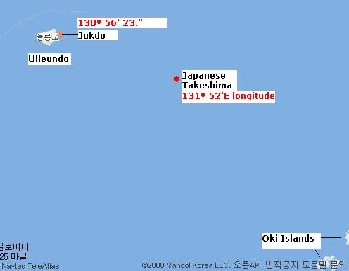
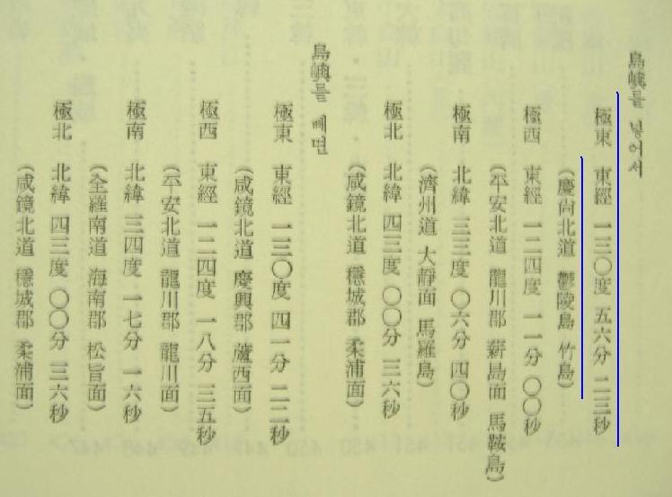
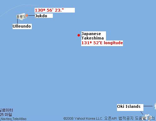
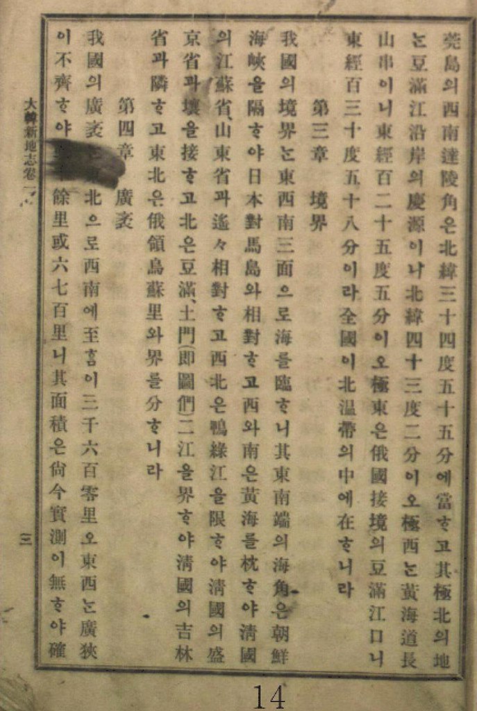
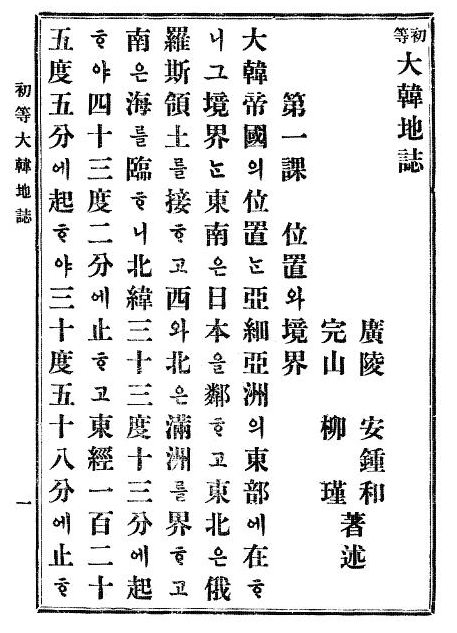
Especially interesting among the books in the list is Choi Nam-seon's (崔南善) 1948 book, "Common Knowledge of Joseon" (朝鮮常識), which specifically says that Korea's easternmost island was Ulleungdo's "Jukdo" in North Gyeongsan Province (慶尚北道鬱陵島竹島). Jukdo is a small island located about two kilometers off Ulleungdo's eastern shore, which matches up with old Korean maps and documents that showed Usando (于山島) to be Korea's eastern most island. Though Koreans claim Usando was Korea's old name for "Dokdo," Korea's old maps and documents show that Usando was actually Ulleungdo's neighboring island of Jukdo, which is at an east longitude of approximately 130º 56' 23." Again, that longitude essentially matches up with longitudes mentioned in the documents below. Ulleundo and Jukdo with longitude (This is a re-revised version of "1894-1948 Korean territory (Revised version)," which was posted by Pacifist.)

1887 "朝鮮八道誌" by 小松運 130º 35' E. longitude (東経130度35分)

1890 "外国地理" by 高木怡荘 130º E. longitude (東経130度)

1891 "受験応用万国小地誌" by 谷口流鶯 130º E. longitude (東経130度)

1894 "新撰朝鮮地理誌" by 大田才次郎 130º 35' E. longitude (東経130度35分)

1894 "朝鮮志" by 足立栗園 130º 36' E. longitude (東経130度36分)

1894 Jul. "新撰朝鮮国地図" by 林正 130º 35' E. longitude (東経130度35分)

1894 Nov. "朝鮮水路誌" by Waterway Section of Japanese Navy (海軍水路部) 130º 35' E.longitude (東経130度35分) (序 : 肝付兼行 海軍省水路部長 Preface by Kimotsuki)

1894~1897 "Korea and Her Neighbours" by Isabella Lucy Bird 130º 33' E. longitude (東経130度33分)

1895 "外国地誌" by 秋山四郎 130º 40' E. longitude (東経130度40分)

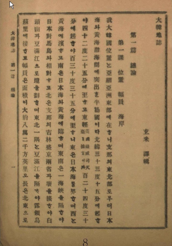
1899 "大韓地誌" by 玄采 (Korean Geography Textbook) 130º 35' E. longitude (東経130度35分)

1899 "新式万国地理" by 岩崎重三 130º 35' E. longitude (東経130度35分)

1900 "新撰大地誌 前編(世界之部)" by 山上万次郎 130º 35' E. longitude (東経130度35分 : 図満江〔註:豆満江) 教師用参考書)

1901 "大韓地誌" by 玄采 (Korean Geography Textbook) 130º 35' E. longitude (東経130度35分)

1901 "朝鮮開化史" by 恒屋盛服 130º 35' E. longitude (東経130度35分)

1902 "高等地理学講義" by 永田健助編 131º E. longitude (東経131度)

1902 "新撰世界地理問答" by 武田鶯塘 130º 40' E. longitude (東経130度40分)

1903 "韓海通漁指針" by 東京 黒龍会 葛生修吉 130º 35' E. longitude (東経130度35分)(序 : 牧朴真 農商務省水産局長 Preface by Maki)

1904 "韓国地理" by 矢津昌永 130º 58' E. longitude (東経130度58分)

1904 "最新韓国実業指針" by 岩永重華 130º 35' E. longitude (東経130度35分)(序 : 山座円次郎 外務省政務局長 Preface by Yamaza)

1904 "朝鮮移住案内" by 山本庫太郎 130º 35' E. longitude (東経130度35分)

1905 "日本民族の新發展場萬韓露領地誌" by 岡部福蔵 130º 35' E. longitude (東経130度35分)

1905 "韓国新地理" by 田淵友彦 130º 58' E. longitude (東経130度58分)

1906 "大韓地誌" by 玄采 (Korean Geography Textbook) 130º 35' E. longitude (東経130度35分)

1906 "韓国水産業調査報告" by 農商務省水産局 130º 35' E. longitude (東経130度35分)

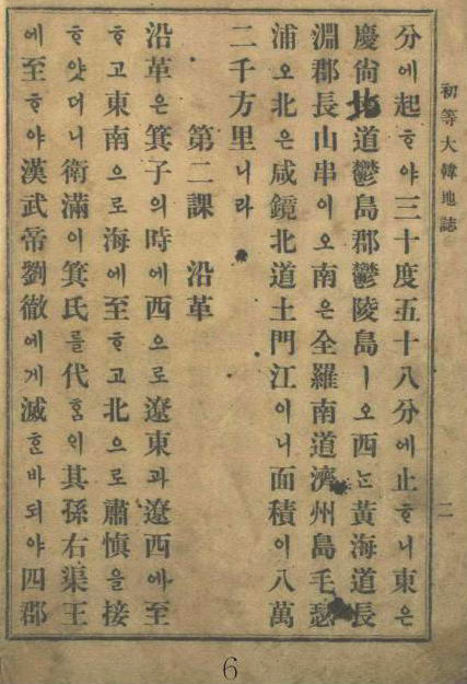
1907 "初等大韓地誌" by 安鍾和 (Korean Geography Textbook) 130º 58' E. longitude (東経130度58分)

1907 "大韓新地志" by 張志淵 (Korean Geography Textbook) 130º 58' E. longitude (東経130度58分)

1907 "外国地理表解" by 小林杖吉 130º 35' E. longitude (東経130度35分)

1908 "初等大韓地誌" by 安鍾和 柳柳瑾 (Korean Geography Textbook) 130º 58' E. longitude (東経130度58分)

1909 "最新高等大韓地誌" by 鄭寅琥 (Korean Geography Textbook) 130º 35' E. longitude (東経130度35分 慶尚南道鬱島郡鬱陵島 : Ulleundo, Ulleudo County)

1909 "韓国水産誌" by 統監府農商工部水産局 130º 42' E. longitude (東経130度42分)

1909 Mar. "大韓協会会報第12号 地誌" (Korean Geography journal) cache 130º 35' E. longitude (東経130度35分)

1910 Feb. "朝鮮新地誌" by 足立栗園 130º 58' E. longitude (東経130度58分)

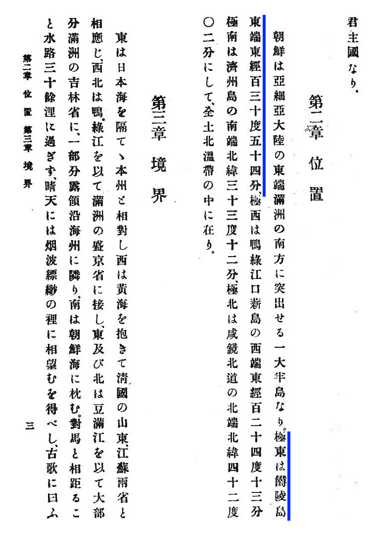
1911 "朝鮮及南満洲地理教授備考" by 亀井忠一 130º 54' E. longitude (東経130度54分 極東 鬱陵島東端 : Easternmost of Ulleundo)

1911 "最新日本地理資料" by 井原儀 130º 54' E. longitude (東経130度54分 極東 鬱陵島(松島)の東端 : Easternmost of Ulleundo(=Matsushima))

1911 Apr. "大日本地理集成" by 矢津昌永等 130º 58 E. longitude (東経130度58分 豆門江の江口)

1911 "韓国通覧" by 統監府農商工部 130º 54' E. longitude (東経130度54分 鬱陵島東端 : Easternmost of Ulleundo)

1912 "最近朝鮮事情要覧" by 朝鮮総督府 2版渡辺為蔵 130º 54' E. longitude (東経130度54分)

1912 "小学地理教材" by 北垣恭次郎 130º 54' E. longitude (東経130度54分 鬱陵島の東端 : Easternmost of Ulleundo)

1912 "最新 朝鮮地誌" by 日韓書房編集部 130º 54' E. longitude (東経130度54分 鬱陵島東端 : Easternmost of Ulleundo)

1936 "朝鮮現勢便覧" by 朝鮮総督府 130º 56' 23" E. longitude (東経130度56分23秒)

1947 "朝鮮常識問答" (Qs& As about common sense of Chosun) by 崔南善 (Korean Geography Textbook) 130º 56' 23" E. longitude (東経130度56分23秒 )

1948 "朝鮮常識" (Common sense of Chosun)" by 崔南善 (Korean Geography Textbook) 130º 56' 23" E. longitude (東経130度56分23秒 慶尚北道鬱陵島竹島 : Jukdo of Ulleundo, (*not Japanese Takeshima)

29.3.08

Korea to Use "National Geographic" to Publicize Dokdo Sovereignty

Below is a link to an article reporting that North Gyeongsang Province (慶尙北道) officials plan to use "world-renowned media corporations," including National Geographic, to promote the "history, geography, and natural resources of Dokdo and Ulleungdo." They believe that a documentary on the islands will help strengthen Korea's sovereignty claim over Dokdo (Liancourt Rocks).

I do know about the other media corporations they plan to use, but I do not think their plan for promoting Korean sovereignty over Dokdo will work with National Geographic, which I suspect will want to give a more balanced historical description of the islands than Koreans may want. I think rather than promoting Korean sovereignty over Dokdo, such a documentary with National Geographic will only serve to inform the world that Korea's sovereignty claims on "Dokdo" are disputed by Japan.

Actually, I wish the "History Channel" would do a program on the history of Ulleungdo and Liancourt Rocks (Dokdo/Takeshima). I think that would be interesting.

Here is a link to the English article:

"Dokdo to enchant TV audiences worldwide"

Here is a link to what appears to be a Japanese translation of a Yonhap News article on the Korean plan:

慶尚北道、海外放送通じて独島・鬱陵島知ら

26.3.08

Takeshima Not Mentioned in Japanese Educational Guidelines

These days it seems that both Korea and Japan have stopped talking about the dispute over Liancourt Rocks (Dokdo/Takeshima), apparently in an attempt to improve the relationship between the two countries. Even scholars from both countries seem to be avoiding public discussion of the subject. And according to a Korean article HERE, the Japanese Ministry of Education has removed mention of Takeshima from its educational guidelines to Japanese teachers.

I think it is good that both the Korean and Japanese governments are trying to improve relations by not making Liancourt Rocks (Dokdo/Takeshima) an issue, but I do not understand why the Japanese government would not want Japanese students to know the facts surrounding the dispute?

Teaching about the Liancourt Rocks dispute and not making it a diplomatic issue are two separate things. Japanese educators should be allowed to do their job while Japanese diplomats do theirs.

The following is my translation of a Korean article, HERE, from Korea's "Maeil Business" newspaper:
"'Dokdo' Contents Removed from Japanese Educational Guidelines"

It has been revealed that the Japanese Ministry of Education, Culture, Sports, Science and Technology removed mention of Japanese sovereignty over Dokdo (Takeshima) and Senkaku (尖閣) Islands in a February amendment to its Educational Guidelines. This measure was adopted by Prime Minister Yasuo Fukuda, who places importance on Asian diplomancy, to avoid friction with Korea and China.

However, during a meeting of the Education Committee of the House of Representatives, which convenced on the 21st, Democratic Party Diet Representative Maki Yoshio said, "Takeshima (Dokdo) and Senkaku must be mentioned in the guidelines," and "showing concern for and compromising with neighboring countries are separate issues."

22.3.08

Samcheok Museum's "Ulleungdo Dohyeong"

Below is an old Korean map of Ulleungdo called "Ulleungdo Dohyeong" (鬱陵島圖形). The exact date of the map is unknown, but it is believed to have been made sometime in the latter part of the Joseon Dynasty (1392 - 1910), before 1882. The map is the property of the Samcheok Municipal Museum (三陟市立博物館).

Could we work on translating it together?


20.3.08

Some Interesting Photos of Ulleungdo

Here is a link to some interesting photos of Ulleungdo. Notice how steep the cliffs are.

Link to a lot of pictures of Ulleungdo

Another link

http://blog.naver.com/gongjoo0270/48857053

19.3.08

2008 - "10 Issues of Takeshima" by MOFA

2008 10 issues of Takeshima by MOFA_1

The Ministry of Foreign Affairs of Japan published the new brochure for Takeshima in Feb. 2008. You can download them in Japanese, English and Korean from their site below.

Japanese Ministry of Foreign Affairs ( English [PDF] /Japanese [PDF] /Korean [PDF] )

2008 - "10 Issues of Takeshima" by MOFA

Point 1. Japan has long recognized the existence of Takeshima.


A group of island that are currently called Takeshima were once known as "Matsusihma," and the island that is now known as Utsuryo (pronounced Ulleung in Korean) used to be known as "Takeshima" or "Isotakeshima." Although there has been a period of temporary confusion concerning the names of Takeshima and Utsuryo Island due to an error in the charting of Utsuryo Island by European explorers and others, it is obvious from a variety of written of written ducuments that Japan has long recognized the existence of "Takeshima" and "Matsushima." For example, on many maps, including "Kaisei Nippon Yochi Rotei Zenzu (Revised Complete Map of Japanese Lands and Roads: first published in 1779)" by Sekisui Nagakubo, which is the most prominent published cartographic projection of Japan, the locations of Utsuryo Island and Takeshima are accurately recorded at their current position between the Korean Penninsula and the Oki Islands.

Point 2. There is no evidence that the ROK has long recognized the existence of Takeshima.

2-1
The ROK claims that, based on what is recorded in old Korean texts such as "Samguksagi(History of the Three Kingdom : 1145)", "Sejong Sillok Jiriji(Geographical Appendix to the Veritable Records of King Sejong: 1454)", "Sinjeung Dongguk Yeoji Seungnam(A Revised Edition of the Augmented Study of Korea : 1531)", "Dongguk Munheonbigo(Study of Korean Documents: 1770)", "Mangi Yoram(Handbook of State Affairs: 1808)" and "Jeungbo Munheonbigo (Augmented Study of Documents: 1908)", Koreans had long been aware of the existence of the two islands of Utsuryo and Usan Island, and that this very Usan Island is the Takeshima of today.

2-2
However, whereas in "History of the Three Kingdoms", there is a description that Utsuryo Island which belonged to Usan Country became a part of Silla in the year of 512, but thee is no mention of Usan Island. Moreover, in records concerning Usan Island in ancient Korean documents, the island is described as a place in which many
people lived, and where large bamboo groves were cultivated. Such description does not represent the realities of Takeshima and rather reminds us of Utsuryo Island.

2-3
The ROK side claims that Usan Island is what the Japanese called Matsushima (present day Takeshima) based on the description in "Yeojiji (Record of Geography: 1656)" cited in "Study of Korean Documents", "Augmented Study of Documents" and "Handbook of State Affairs." However, there is a study which criticizes that the original text in "Record of Geography" indicates that Usan Island and Utsuryo Island are two names for one island and that the description in the documents such as "Study of Korean Documents" are indirect and inaccurate quotations from "Record of Geography". The study makes the point that the description in those documents were copied from "Ganggyego (Study of National Boundary)" (part of "Ganggyeji (Record of National Boundary: 1756)"), which had uncritically borrowed from the unreliable deposition by Ahn Yong-Bok (refer to point 5).
2-4
In the map attached to "A Revised Edition of the Augmented Survey of the Geography of Korea," Utsuryo Island and Usan Island are described as two separate islands. If, as the ROK claims, Usan Island were the present Takeshima, then it should have been described as a much smaller island than Utsuryo Island situated east of Utsuryo Island. However, the Usan Island is portrayed on the map as being roughly of the same size as Utsuryo Island, and situated between the Korean Peninsula and Utsuryo Island (west of Utsuryo Island). This clearly shows that that island does not exist at all in reality.

Point 3. Japan used Takeshima as a stopover port en route to Utsuryo Island and as fishing ground. It thus established its sovereignty over Takeshima by the mid 17th century at the very latest.

3-1
In 1618 (Note), two merchants of Yonago in the region of Houki-no-kuni in Tottori clan--Jinkichi Ohya and Ichibei Murakawa--received permission for passage to Utsuryo Island (then "Takeshima") from the Shogunate via the feudal lord of Tottori. Subsequently, the two families took turns in traveling to Utsuryo Island once every year, and engaging in catching abalone and sea lions, and in felling trees, including bamboo. (Note) Some believe that it was in 1625.

3-2
Both families built ships bearing the sails emblazing the hollyhock crest of the ruling that was caught being sent in tribute to the Shogunate and others. The families were thus engaged in a kind of Shogunate-approved monopoly on the island.

3-3
During this period, Takeshima that was on the route from Oki to Utsuryo Island was a navigational port and docking point for ships. It was naturally utilized as a rich fishing ground for sea lions and abalone.

3-4
Therefore, we firmly believe that Japan has established the sovereignty of Takeshima by the beginning of the Edo Period (1603-1867) in the mid 17th century at the very latest.

3-5
If the Shogunate then had recognized Utsuryo Island and Takeshima as foreign territories, it should have banned passage to these islands in 1653 when it issued its directive of "sakoku", closing Japan to the outside world and prohibiting Japanese from traveling abroad. However, no such measure was actually taken.

Point 4. At the end of the 17th century Japan prohibited passage of ships to Utsuryo Island, but not to Takeshima.

4-1
With the permission of the Shogunate to make passage for Utsuryo Island, the Ohya and Murakawa families of Yonago engaged in their monopolistic business enterprise unhindered by others for approximately 70 years.

4-2
In 1692 when the Murakawa family traveled to Utsuryo Island, they encountered many Korean on the island engaged in fishing. The following year, when the Ohya family made the the journey to the island, they also met with many Koreans and decided to bring two of these Koreans, Ahn Yong-Bok and Park Eo-Doon, back with them to Japan. This was at a time that the royal dynasty of Korea prohibited its people from travelling to Utsuryo Island.

4-3.
The feudal clan of Tsushima(which was the point of contact with the Korean Government at that time), following directions from the Shogunate, which had become aware of the situation, repatriated Ahn and Park to Korea, and initiated negotiations with Korean requesting it to prohibit its fishermen's passage to Uturyo island. However, these negotiations failed to reach agreement, given a difference in opinions concerning the attribution of Utsuryo Island.

4-4
Having received a report from the Tsushima clan concerning the breaking-off of negotiations, the Shogunate decided to prohibit passage to Utsuryo Island in January 1696, judging that it is in the best interest of Japan to maintain favorable relations with Korea, The Tsushima clan was directed to convey this decision to the Korean side. The course of these negotiations concerning the attribution of Utsuryo Island is known generally as the "Takeshima Ikken (The Affair of Takeshima)."

4-5
On the other hand, passage to Takeshima was not banned. This clearly shows that Japan has regarded Takeshima as its territory since then.

Point 5. The deposition by Ahn Yong-Bok, on which ROK side bases its claim, contains many points that conflict with factual evidence.

5-1
After the Shogunate decided to prohibit passage to Utsuryo Island, Ahn Yong-Bok came once again to Japan. After that, Ahn, who was once again repatriated to Korean, was interrogated by the Korean officials as being in contravention of the ban on travel to Utsuryo Island. The deposition made by Ahn at the time is cited by the ROK side today as one of the foundations for its claim on the sovereignty over Takeshima.

5-2
According to documents held by the ROK side, Ahn
Yong-Bok confessed that while in Japan he had acquired a written document from
the Edo Shogunate that indicated the Shogunate's acceptance of Utsuryo Island and Takeshima as territories of Korea. He also confessed that this document was later confiscated by the lord of Tsushima. However, according to documents held by the Japanese side, although there are records of Ahn Yong-Bok having visited Japan in 1693 and 1696, there are no records that a written document such as that claimed by the ROK side was ever given to Ahn Yong-Bok.

5-3
Moreover, according to the documents held by the ROK side, Ahn Yong-Bok is reported to have stated on his 1696 visit to Japan that there were many Japanese on Utsuryo Island. However, his visit to Japan on that occasion was after the Shogunate had decided to prohibit passage to Utsuryo Island, and neither the Ohya nor Murakawa family went to the island at that time.

5-4
The descriptions on Ahn Yong-Bok in the documents held by the ROK side are based on the deposition made by a person who had raveled overseas violating national prohibition, and was interrogated upon his return to Korea. The deposition contains many points that conflict with factual evidence, including but not limited to those mentioned above. Regardless of that, these descriptions have been cited by the ROK side as one of the foundations for sovereignty over Takeshima.

Point 6. Japan reaffirmed its intention to claim sovereignty over Takeshima by incorporating Takaeshima into Shimane Prefecture in 1905.

6-1
It was at the beginning of the 1900s that sea lion hunting came to be undertaken in a full fledged manner in Takeshima. However, since there quickly grew to be excessive competition in sea lion hunting, Yozaburo Nakai, a resident of the Oki Islands of Shimane Prefecture, who aimed to stabilize his sea lion hunting business submitted a request in September 1904 to three government ministers (Home Minister, Foreign Minister, Agriculture and Commerce Minister) to incorporate the territory of the Lyanko Islands and to extend a 10-year lease on its utilization.
(Note) "Lyanko Islands" was a Japanese colloquial term for Takeshima derived from "Liancourt Islands," the Western name given to Takeshima. At that time, Utsuryo Island came to be called “Matsushima” in addition to “Takeshima” and current Takeshima came to be called to “Lyanko Islands” in addition to “Matsushima” due to charting errors by European explorers.

6-2
Having received the request from Nakai, the Government of Japan, hearing opinions from Shimane Prefecture, confirmed that there is no problem in bringing Takeshima under the jurisdiction of the Okinoshima branch and that "Takeshima" is the appropriate name for the island. With this confirmation, the Government, in January 1905, through a Cabinet decision, stipulated that the islands came under the jurisdiction of the Okinoshima branch of Shimane Prefectural Government, and that the island were officially named as "Takeshima." This decision was conveyed to the Governor of Shimane Prefecture by the Minister for Home Affairs. With this Cabinet Decision, Japan reaffirmed its intention to claim sovereignty over Takeshima.

6-3
Based on the Cabinet Decision and the Ministerial Instruction from the Minister for Home Affairs, the Governor of Shimane Prefecture published in February 1905 that Takeshima was officially named as "Takeshima" and that it came under the jurisdiction of the Okinoshima branch. He also informed the Okinoshima branch to this effect. These measures were carried in the newspapers of the day and were broadly publicized.

6-4
Based on the Cabinet Decision stipulating that Takeshima came under the jurisdiction of the Okinoshima branch of Shimane Prefectual Government, the governor registered Takeshima into the State Land Register, and established a license system for sea lion hunting. The hunting of sea lions continued from then until 1941.

6-5
In Korea, it is said that records exist that according to the stipulations of Imperial Ordinance No. 41 of 1900, not only was the name Utsuryo Island to be changed to Utsu Island (pronounced Uldo in Korean), but that the monitoring of the island would be henceforth undertaken by a county magistrate. Some researchers point out that this ordinance stipulates that the region under the jurisdiction of Utsuryo County included "all of Ulleungdo (Utsuryo Island), Jukdo (Takeshima) and Seokdo (Ishijima)," (the names of the islands are written in Chinese characters (ideogram)) and that, while this "Jukdo" refers to a small island called "Chikusho" adjacent to Utsuryo Island, "Seokdo" (literally meaning “stone island”) actually corresponds to the current "Dokdo." According to the researchers, , Seokdo ( 石島) turned to Dokdo (独島) (literally meaning lone island) because they are phonetically interchangeable in a Korean dialect despite the fact that they do not share the same ideograms.

6-6
If it were, however, the case that "Seokdo" corresponds to the current Takeshima ("Dokdo"), there would be doubts as to why the Imperial Ordinance of 1900 did not use "Dokdo" in the text, why the name "Usan Island," which the ROK claims to be the former name of Takeshima, was not used, and when and how the name Dokdo was first used.

6-7
Whatever the case, even assuming such doubts will be cleared, there is no evidence that Korea had ever exercised effective control over Takeshima around the time of the promulgation of the Imperial Ordinance. Therefore, it is considered that Korea had never established sovereignty over Takeshima.

Point 7. In the drafting process of the Treaty of Peace with Japan, the United States rejected the request by the ROK that Takeshima be added to the relevant article of the Treaty as one of the areas Japan would renounce, claiming that Takeshima had been under the jurisdiction of
Japan.

7-1
The San Francisco Peace Treaty, signed in September 1951, stipulates that “Japan, recognizing the independence of Korea, renounces all right, title and claim to Korea, including the islands of Quelpart, Port Hamilton and Dagelet."

7-2
Upon learning of the content of this part of the Treaty drafted by the United States and the United Kingdom in July 1951, the ROK had You Chan Yang, Korean Ambassador to the United States, send a letter to Dean G. Acheson, the Secretary of State of the United States. In the letter, the Ambassador wrote, "My Government requests that the word ’renounces’ in Paragraph(a), Article Number 2, should be replaced by confirms that it renounced on August 9, 1945, all right, title and claim to Korea and the islands which were part of Korea prior to its annexation by Japan, including the islands Quelpart, Port Hamilton, Dagelet, Dokdo and Parangdo."

7-3
In August of the same year, the United States responded to the letter by a letter from Dean Rusk, United States Assistant Secretary of State for Far Eastern Affairs to Ambassador Yang. The content of the response was, "...the United States Government does not feel that the Treaty (San Francisco Peace Treaty) should adopt the theory that Japan's acceptance of the Potsdam Declaration on August 9, 1945 constituted a formal or final renunciation of sovereignty by Japan over the areas dealt with in the Declaration. As regards the island of Dokdo, otherwise known as Takeshima or Liancourt Rocks, this normally uninhabited rock formation was according to our information never treated as part of Korea and, since about 1905, has been under the jurisdiction of the Oki Islands Branch Office of Shimane Prefecture of Japan. The island does not appear ever before to have been claimed by Korea." Based on this correcspondence, it is evident that Takeshima was affirmed as part of the territory of Japan.

7-4
The report of Ambassador Van Fleet (refer to point 10) states that "the United States concluded that they (the islands of Takeshima) remained under Japanese sovereignty and the Island was not included among the Islands that Japan released from its ownership under the Peace Treaty. "


Point 8. In 1952, Takeshima was designated as a bombing range for the U.S. Forces stationed in Japan, which shows that Takeshima was treated as part of the territory of Japan.

8-1
In July 1950, while Japan was still under Allied occupation, the supreme command for allied Powers designated Takeshima as a bombing range for U.S. Forces by an instruction note (SCAPIN-2160).

8-2
In July 1952, given the expressed desire by the U.S. Forces to continue to utilize Takeshima as a training area, the Joint Committee established for the purpose of implementing the Japan-U.S. Administrative Agreement under the Japan-U.S. Security Treaty designated Takeshima as a bombing range for the U.S. Forces stationed in Japan. The Ministry of Foreign Affairs promptly published this fact through the Official Gazette.

8-3
The Japan-U.S. Administrative Agreement stipulated that the Joint Committee shall serve as the means for consultation in determining the facilities and areas in Japan. Therefore, the fact that Takeshima was discussed in the Committee and the fact that the island was designated as an area for use by the U.S. Forces stationed in Japan clearly shows that Takeshima is part of the territory of Japan.

Point 9. The ROK is illegally occupying Takeshima, against which Japan has been consistently making strong protests.

9-1
In January 1952, the President of the ROK Syngman Rhee issued a Declaration concerning maritime sovereignty, with which he installed the so-called "Syngman Rhee Line." Installation of this "line" encompassing the islands of Takeshima was a unilateral act in contravention of international law.

9-2
In March 1953, the Joint Committee decided to release Takeshima from the designation of a bombing range for the U.S. Forces. It prompted resumption of fishing by Japanese on and around Takeshima, where it was confirmed at the same time that there were also Koreans engaged in fishing. In July of the same year, a Japanese patrol vessel of the Maritime Safety Agency (now the Japan Coast Guard) that demanded Koreans engaged in illegal fishing to leave the vicinity of Takeshima was fired upon by the Korean authorities that were supporting and protecting the Korean fishermen.

9-3
In June 1954, the Ministry of Home Affairs of the ROK announced that the ROK Coast Guard had urgently dispatched a permanent battalion on Takeshima. In August of the same year a vessel of the Maritime Safety Agency on patrol in the vicinity of Takeshima was fired on from Takeshima. Through this incident, it was confirmed that the ROK security personnel had been stationed on Takeshima.

9-4
Since then,the ROK has kept and keeps, security personnel stationed on Takeshima as well as constructing lodgings, a monitoring facility, a lighthouse, and port and docking facilities.

9-5
The occupation of Takeshima by the ROK is an illegal occupation undertaken on absolutely no basis of international law. No measure taken by the ROK during its illegal occupation with regard to Takeshima has any legal justification. This illegal occupation is not acceptable in any way, gien Japan's position on its sovereignty over Takeshima. Japan has been consistently making strong protests against each and every measure taken by the ROK and demanding the withdrawal of the measure.

Point 10. Although Japan proposed to the ROK that the dispute over Takeshima be referred to the International Court of Justice, the ROK rejected this proposal.

10-1
Since the installation of the "Syngman Rhee Line" by the ROK, Japan has been repeated protesting against the ROK's actions such as claims of sovereignty over Takeshima, fishing activities around Takeshima, fires against patrol vessels, and the construction of structures on the island. In order to resolve the dispute in a peaceful manner, Japan proposed, with a note verbale, to the ROK that the issue concerning the sovereignty of Takeshima be referred to the International Court of Justice in September 1954. However, the ROK rejected this proposal. In addition, on the occasion of the Foreign Ministerial talks in March 1962, Zentaro Kosaka, then Minister for Foreign Affairs of Japan, made a proposal to Choi Duk-shin, then Minister of Foreign Affairs of the ROK, to refer the issue to the Court, but this proposal was not accepted by the ROK again. This situation remains the same until now.

10-2
The International Court of Justice has jurisdiction over a dispute only when the parties to the dispute have agreed to bring the case to the Court. Accordingly, even if Japan refers the issue to the Court unilaterally, the ROK has no obligation to respond to it, and the Court will not have jurisdiction until the ROK voluntarily accepts it.

10-3
According to the report of Ambassador Van Fleet who visited the ROK in 1954, which was made public in 1986, the United States concluded that Takeshima is Japanese territory, and took the position that the dispute might properly be referred to the International Court of Justice. Ambassador Fleet reports that though the United States conveyed this suggestion to the ROK, the ROK argued that “Dokto” was a part of Utsuryo Island.

12.3.08

Samcheok Museum's "Ulleungdo Dohyeong" (鬱陵島圖形)

Below is an old Korean map of the Korean island of Ulleungdo, entitled "Ulleungdo Dohyeong" (鬱陵島圖形). The map is the property of the Samcheok Municipal Museum (三陟市立博物館), but is currently on display at the Gyeonggi Cultural Foundation (京畿文化材團) Art Center in Suwon until March 31. The exact date of the map is unknown, but it is believed to have been made sometime in the latter part of the Joseon Dynasty (1392 - 1910), before 1882.

For some reason, Ulleungdo was drawn upside down on the map since the top of the map shows the southern shore and the bottom shows the northern shore. Accordingly, Ulleungdo's eastern shore appears on the left side of the map. One of the interesting things about this map is that the two largest islands off Ulleungdo's eastern shore (left side) are labeled 大于島 (Dae-Udo) and 小于島 (So-Udo), which literally mean "large Udo" and "small Udo," respectively. The "large Udo" is believed to have been Ulleungdo's present-day neighboring island of Jukdo (竹島), which is about two kilometers off Ulleungdo's eastern shore, while the "small Udo" is believed to have been Ulleungdo's Gwaneumdo (觀音島), which is about 100 meters offshore.


Korean Link

10.3.08

Is Mark Lovemo's "Dokdo" Web site history?

Has Mark Lovemo deleted his Dokdo Web site, which argued in support of Korea's claim to the island? I noticed today that the link no longer works. Did he finally open his eyes to the truth?

It seems "Dokdo" Web sites are suffering slow, painful deaths.

Here is the old link to Mark's site:

http://www.geocities.com/mlovmo/page4.html

9.3.08

The 5th column “Seeking Truth Based Solely on Facts(実事求是)”

Below is a translation of The 5th column “Seeking Truth Based Solely on Facts(実事求是)” by Prof. Shimojo Masao

.

"South Korea’s erroneous interpretation of the document 'Takeshima and Another Island are Unrelated to Japan'"

.

The Takeshima Day ceremony held at the Shimane Prefectural Hall on February 22 seems to have attracted South Korean interest, as the Dokdo Headquarters in that country fanned the flames of the dispute by offering the following explanation of the origins of the Takeshima controversy: “The Japanese refer to Dokdo as Takeshima, or Bamboo Island, though the island has no bamboo whatsoever. The reason they call it the island of bamboo is that in the local dialect of Korea’s Jeolla Province, “dok” is pronounced as “tok”. Thus the pronunciation of the island’s name of Tokushima evolved into Takeshima. Japan established Takeshima Day in 2005, and they are increasingly resorting to such thieving trickery to snatch Dokdo and make it Japanese territory.”

.

On the day of the ceremony, the Yonhap News Agency of South Korea reported the discovery of a Japanese map with a color code indicating Dokdo was Korean territory. This story was repeated by the Kyunghyang Shinmun, Dong-a Ilbo, the Korean edition of World Times, and Ko-news.

.

The story arose with the announcement by Hosaka Yuji of Sejong University that two Japanese maps show Takeshima to be Korean territory. This announcement was based on only two maps, including the “Shinsen Chosen Zenzu (新撰朝鮮全図) ”, or New Map of Choseon. But the declaration from the Dokdo Headquarters and Hosaka Yuji’s view merely reveal the limits of South Korean capabilities to interpret old documents. On the contrary, the map verifies that Takeshima was not Korean territory.

.

If they could read the order of the Japanese Council of State (Cabinet) “Takeshima and Another Island are Unrelated to Japan”, they wouldn't confuse Matsushima, which was the other island, with today’s Takeshima or attribute it to the Jeolla Province dialect. The critical factors for the Takeshima issue are critiques of documents and objective historical facts.

.

South Korea thinks that reference was being made to today’s Takeshima in the Council of State order, but that’s just a superficial analysis. The Kobunroku (Official Documents) included a rough map of Isotakeshima and a document collected when Shimane prefecture asked the government about including Ulleungdo and Takeshima in the prefecture in 1876. The content of the documents were confusing, however.

When Shimane Prefecture compiled the documents, they described Isotakeshima as Ulleungdo. They also described Matsushima as the Ulleungdo to which the Oya and Murakawa families of Yonago in the Tottori domain were authorized by the Shogunate to travel. Thus, they recorded two Ulleungdos.

.

There was a reason for that confusion. In those days a “Takeshima” that did not exist was depicted in maps and charts made in the West, and the Japanese cartographers followed suit. That was due to both Hayashi Shihei’s “Sangoku Setsujozu(三国接壌図)” (1785), which contained two Ulleungdos, and Philipp von Siebold’s Map of Japan (1840), in which Takeshima (Argonaut Island) was drawn at 129 degrees 50 minutes east longitude, and Matsushima (Dagelet Island) was drawn at 130 degrees 56 minutes east longitude. The Takeshima in the latter map, which gained currency in the West, was Argonaut Island--which did not exist. Today’s Takeshima, at 131 degrees 55 minutes east longitude, began to appear in charts after 1849 when the French whaling ship Liancourt came across the island. Neither of the two maps that Mr. Hosaka “discovered” includes today’s Takeshima.

.

After that, the survey conducted by the warship Amagi in 1880 revealed that Matsushima was Ulleungdo. The islet that Pak Chang-seok(朴錫昌) designated as the “so-called Usando” in 1711 was called Takeshima, or Jukdo in Korean. In 1882, Lee Gyu-wen(李奎遠) produced a map after his survey of Ulleungdo; he also called the island Jukdo.

.

Ryanko island (Liancourt Rocks), which was unclaimed until 1904, was called Takeshima by Azuma Bunsuke, the administrator of Oki Island, because Ulleungdo was referred to as Matsushima when it was under Oki Island jurisdiction and they had to use the remaining name of Takeshima (as seen in the official document #152). The Dokdo Headquarters’ explanation that the name of Takeshima originated from a Jeolla Province dialect is not true.

.

Now, the Dokdo Protection Squad of South Korea has brought some pamphlets that show a copy of the order from the Council of State. I immediately used it in my Takeshima Day lecture as an example of their inability to read documents. The more that South Korea continues its historical offensive, the clearer it becomes that Takeshima was not Korean territory.

.

“実事求是 〜日韓のトゲ、竹島問題を考える〜 第5回 韓国側による「竹島外一島、本邦関係無之」の解釈の誤り 下條正男”


Translated by Pacifist

Edited by William Sakovich

Courtesy of Web Takeshima Research Center


Other Column of the Series:

The 24th column “South Korean Government dug their own grave by publishing the English version of "The Dokdo/Takeshima Controversy" by Prof. Emeritus Naito Seichu and Mr. Park Byeong-seop.”


The 23rd column " Refutation against the report of South Korean Yonhap News Agency which misread the Mori Kohan(森幸安)'s "The Map of Tsushima(對馬輿地図)"


The 22th column “ Refutation against "The Meiji Government's recognition of Takeshima=Dokdo" by Mr. Park Byeong-seop(朴炳渉)””, Part 1, Part 2, Part 3, Part 4

The 21st column " Refutation against "Analysis of Shimojo Masao's Editorials" by Mr. Park Byeong-seop(朴炳渉)”

The 20th column “Act of Folly by "Northeast Asian History Foundation"”

The 19th column “"Korea Maritime Institute(KMI : 韓国海洋水産開発院), who lacks ability to read their own historical documents, criticized on Shimane Prefecture. "”

The 18th column “Absurd and Peculiar Theory of Prof. Hosaka, plus the "Children and textbook nationwide net 21" and others' Getting "Out of Control.””

The 17th column “The Ordinance of Prime Minister and Cabinet Office, No.24 and the Ordinance of the Ministry of Finance, No.4 in 1951(昭和26年).”

The 16th column ""Dokdo Month" without any historical grounds."

The 15th column " South Korea's Groundless Claim of "Inherent Part of (Korean) Territory"

The 14th column “A reckless Courage of the Professor Kimishima Kazuhiko(君島和彦) of Tokyo Gakugei University(東京学芸大学).

The 13th column “Sins of Asahi Shimbun and Mr. Wakamiya Yoshibumi(若宮啓文).

The 12th column “Northeast Asian History Foundation and Dokdo Research Center's Misunderstanding”

The 11th column “South Korea's Misunderstanding of 'A Map of Three Adjoining Countries (Sangoku Setsujozu 三国接壌図)' by Hayashi Shihei(林子平)”

The 10th column " A Blunder of Sokdo(石島) = Dokto(独島) Theory”

The 9th column "Criticism on Dokdo Research Center”

The 8th column “The Historical Facts" The 6th column “Onshu-shicho-goki (隠州視聴合記)" and the "Nihon Yochi Totei Zenzu (日本輿地路程全図)" by Nagakubo Sekisui(長久保赤水)"

The 5th column “South Korea’s erroneous interpretation of the document 'Takeshima and Another Island are Unrelated to Japan"

The 4th column “Errors in Educational Video Produced by the Northeast Asian History Foundation (東北アジア歴史財団)."


Reference:  Kobunroku(公文録)