竹島問題の歴史

28.9.08

1905 - May 29 , 30 & June 5- 官報号外「日本海海戦戦報」

以下にあげるのは、東郷平八郎連合艦隊司令長官による日本海海戦の報告を掲載した官報号外です。

竹島問題を考える上で注目すべき点が二点あります。一つは、この約四ヶ月前の明治三十八年一月二十八日に正式に「竹島」と名付けて領土編入されたにもかかわらず、「其三」と「其五」に今だ、「リヤンコールド」岩、「リアンコルド」岩とそれぞれ標記されていることです。この報告は、東郷平八郎連合艦隊司令長官による正式な報告であり、東郷のみならず、その参謀達さえも皆四ヶ月前に閣議決定された竹島と言う新しい島の正式名称を使用していなかったことが明らかになりました。つまり、領土編入・改名と言った一連の竹島の帰属に関する事項は、実際には日本帝国海軍にとっては戦略上何の意味も無かったということでしょう。

韓国側(内藤正中氏・保坂氏)が主張するような、「1905年に日帝が断行した自国への独島の領土編入は、ロシアとの戦争を勝利する為に当時の日本政府の要職に就いていた官僚らが、いち漁業者を手引きして作り上げた事であるという事実」、または「特にこれらの官僚(外務省の山座円次郎政務局長、農商務省の牧朴真水産局長、海軍省の肝付兼行水路部長)は、独島が韓国領土であると言う事実をよく理解している立場に居たにも係わらず、 独島を島根県に強制的に編入する『工作』をした事が明らかになった。」などという事実はなく 、彼等の妄想に過ぎないことが明白です。第一、日本政府や海軍の水路部長がそこまで綿密な計画を立てて日露戦争の勝利の為に竹島を領土編入する必要があったのならば、この資料のように、日本海海戦の司令長官である東郷やその参謀達が新たに領土編入までして改名した「竹島」と言う名称を報告書に使用しないはずがありません。この報告からは日本海海戦の戦略的見地からは竹島はおろか鬱陵島などの島々の帰属問題など何の考慮もされていなかったことが明白です。

そもそも、前年の1904(明治三七)年2月23日「日韓議定書」が締結されています。その第四条の2項には"大日本帝国政府ハ前項ノ目的ヲ達スル為軍略上必要ノ地点ヲ臨検収用スルコトヲ得ル事"とあり、軍略上必要な地点は日本政府が収容することが可能になっており、これらの島の帰属問題は日露戦争の遂行には、全く無関係でした。さらに、もし韓国側の主張するように、仮に"悪辣な日帝"が領土的野心の為に、竹島を韓国領だと知った上で島根県に編入したのが事実ならば、何故、より地勢学的、経済学的に竹島よりずっと価値の高い鬱陵島を"強奪"して編入しなかったのでしょうか?韓国人の方が多く居住していたとは言え、20年前までは空島で、当時三百人以上の日本人が滞在しており、しかも1600年代には実効支配していた実績があるのに、です。

もう一つの注目すべき点は、6月5日の続報の最後に、訂正として「リヤンコールド岩」ヲ孰モ「竹島」ニ訂正スと言う一文を載せた点です。官報の号外に海軍の報告中の竹島の名称を訂正する旨を載せたことは、竹島の領土編入が"秘密裏"に行われたなどと言う韓国側の"妄言"を一蹴するものです。実際、ソウルで発行されていた韓国人による韓国語新聞である皇城新聞は、この官報号外と同じ内容のものを翻訳・編集するなどして三日後には既に記事にして内容を伝える記事を載せており、間接的ではあっても韓国人にも十分伝達可能なメディア媒体であった訳です。もし本当に韓国側に極秘にするならば、領土編入を閣議決定した後に島根県が告示し、新聞に掲載したりするはずがありません。ましてや、何らかの形で韓国側にその内容が伝わってしまう可能性の大きい官報号外にリヤンコールド岩、つまり竹島の名称の訂正記事を載せるなど、ありえなかったことでしょう。

例えば、在日韓国人で独島研究センターの外部研究員を勤める半月城こと朴炳渉氏は、其三と五の表記間違いをのみ取り上げ、この訂正部分を無視し、「海軍省や官報を作成する政府機関は「竹島」が日本領になったことを知らず、その島を外国の島と思い込んでいたのかも知れません。それも無理ないかもしれません。何しろ、竹島=独島の領土編入は政府レベルでは極秘になされたので、海軍省や官報の記事を発行する機関すら知らなかったとしても当然かも知れません。」(2005 )などの妄言を掲載していたようです。このような在日韓国人による自国に都合のよい部分のみの資料の恣意的解釈を通しての領土権主張は、正常な日韓関係の阻害要因になるだけではなく、在日韓国人に対する反感にもつながるおそれがある大変憂慮すべき行動であり、厳に謹んで頂きたいものです。


官報号外 明治三十八年五月二十九日

戦報

日本海海戦戦報  一昨二十七日以来継続中ナル日本海海戦ニ関スル連合艦隊司令長官東郷平八郎ノ報告左ノ如シ(海軍省)

其一 一昨二十七日午前著電
敵艦見ユトノ警報ニ接シ連合艦隊ハ直ニ出動之ヲ撃滅セントス本日天候晴朗ナレドモ浪高シ

其ニ  同日夜著電
連合艦隊ハ本日沖ノ島附近ニ於テ敵艦隊ヲ邀撃シ大ニ之ヲ破リ敵艦少クモ4隻ヲ撃沈シ其他ニハ多大ノ損害ヲ与ヘタリ我艦隊ニハ損害少シ駆逐隊水雷艇隊ハ日没ヨリ襲撃ヲ決行セリ

其三 今二十九日午前著電
連合艦隊ノ主力ハ二十七日以来残敵ニ対シテ追撃ヲ続行シ28日
「リヤンコールド」岩附近ニ於テ敵艦「ニコライ」第一世(戦艦)アリヨール(戦艦)「セニヤーウィン」(装甲海防艦)「アブラキシン」(装甲海防艦)及「イズムールド」(巡洋艦)ヨリ成ル一群ニ会シ之ヲ攻撃セシニ「イズムールド」ハ分離シテ逃走セシカ他ノ四艦ハ須臾ニシテ降伏セリ 我艦隊ハ損害ナシ
捕虜ノ言ニ依レバ二十七日ノ戦闘ニ於テ沈没シタル敵艦ハ「ボロジノ」(戦艦)、「アレキサンダー」第三世(戦艦)、「ゼムスチューグ」(巡洋艦)外三隻ナリト云フ
捕虜海軍少将ネボガトフ以下ニ千
(備考)
右ノ外本戦闘開始以来連合艦隊司令長官直卒以外の指揮官又は望楼の報告に係る敵の損害左の如し

「アドミラル・ナヒモーフ」(巡洋艦八五二四噸) 撃沈
「ドミドリー・ドンスコイ」(巡洋艦六二〇〇噸) 撃沈
「ウラジミール・モノマフ」(巡洋艦五五九三噸) 捕獲後沈没
「スウェートラーナ」(巡洋艦三七二七噸) 撃沈
「アドミラル・ウシヤーコフ」(装甲海防艦四一二六噸) 撃沈
「カムチャットカ」(特務艦七二〇七噸) 撃沈
「イルチッシュ」(特務艦七五〇七噸) 撃沈
大型特務艦(船名未タ不詳) 一隻 捕獲
駆逐艦    三隻   撃沈
駆逐艦    一隻   捕獲
即チ敵ノ損害ヲ艦種ニ区別スレハ左ノ如シ
          撃沈     捕獲      計
戦艦       二隻     二隻      四隻
装甲海防艦  一隻     二隻      三隻
巡洋艦     五隻              五隻
特務船     二隻     一隻      三隻
駆逐艦     三隻     一隻      四隻
尚ホ捕虜ノ陳述ニ在ル沈没艦三隻ハ以上ノ中ナルヤ又以外ナルヤ未タ詳ナラス
捕虜は連合艦隊主力部隊ニ於テ収容セル二千ノ外尚ホ一千以上アリ


・・・・・・・・・・・・・・・・・・・・・・・・・・・・・・・・・・・・・・・・・・・・・・・・・・・・・・・・・・・・・・・・・・・・・・・・・・・・・・・

官報号外 明治三十八年五月三十日


戦報

日本海海戦続報  日本海海戦ニ関シ其後接手シタル連合艦隊司令長官東郷平八郎ノ報告左ノ如シ(海軍省)

其四 今三十日午後著電
五月二十七日午後ヨリ翌二十八日ニ亙リ沖ノ島附近ヨリ鬱陵島附近マテノ海戦ヲ「日本海ノ海戦」ト呼称ス

其五 同上
連合艦隊ノ大部ハ前ニ電報シタル如ク一昨二十八日午後「リアンコルド」岩附近ニ於テ敗残敵艦隊ノ主力ヲ包囲攻撃シテ其降伏ヲ受ケ追撃ヲ中止シ之ガ處分ニ従事中午後三時頃更ニ南西方面ニ敵艦「アドミラル、ウシヤーコフ」ノ北走スルヲ発見シ盤手、八雲ハ直ニ之ヲ追撃シ先ツ降伏ヲ勧告セシモ敵之ニ應セサリシ故午後六時過己ムヲ得ス之ヲ撃沈シ其生存者三百余名ヲ救助・収容セリ又午後五時北西ニ敵艦「ヅミトリー、ドンスコイ」ヲ発見シ第四戦隊及第二駆逐隊之ニ追及シ日没後ニ至ルマテ猛烈ニ砲撃セシモ撃沈スルニ至ラス夜ニ入リ第二駆逐隊モ之ヲ襲撃シ其結果不明ナリシカ昨朝ニ至リ第二駆逐隊ハ「ヅミトリー、ドンスコイ」ノ鬱陵島ノ東南岸ニ擱座セルヲ発見シ目下春日ト共ニ其處分中ナリ又漣ハ一昨二十八日夕刻鬱陵島ノ南方ニ於テ敵ノ駆逐艦「ビエドーウイ」ヲ捕獲セリ同艦ニハ二十七日ノ戦闘中沈没シタル敵ノ旗艦「クニヤージ、スワロフ」ヨリ敵艦隊司令長官ロゼトウエンスキー中将、エンクイスト少将及幕僚以下八十余名移乗シ居リシヲ以テ悉ク之ヲ捕虜トセリ
右両将官ハ共ニ重症ナリ又千歳ハ一昨二十八日朝北航ノ途上敵ノ駆逐艦一隻ヲ発見シテ之ヲ撃沈シ新高及叢雲ハ同日正午頃竹邊湾附近ニテ敵ノ駆逐艦一隻ヲ撃破シテ擱岸セシメタルノ報告ニ接セリ
今マテニ得タル諸報告及捕虜ノ言ヲ綜合スルニ二十七日ヨリ二十八日ニ亙レル戦闘ニ於テ撃沈シ得タル敵艦ハ「クニヤージ、スワロフ」「アレキサンダー三世」 「ボロヂノ」「ヅミトリー、ドンスコイ」「アドミラル、ナヒーモフ」「ウラジミール、モノマフ」「ゼムチューグ」、「アドミラル、ウシヤーコフ」、仮装巡 洋艦一隻、駆逐艦二隻ニシテ捕獲艦ハ「ニコライ」一世、「アリョール」、「アドミラル、アブラキシン」、「アドミラル、セニヤーウイン」、「ビェードウ イ」ノ五隻ナリ尚ホ捕虜ノ言ニ依レハ敵ノ戦艦「オスラービヤ」ハ二十七日午後三時、四時ノ交大破ノ後沈没シ又「ナワリン」モ沈没セリト云フ其外第三戦隊ハ 同日日没頃敵艦「アルマーズ」カ身体自由ヲ失ヒ将ニ沈没船トスルヲ目撃セシト云フモ暫ク疑ヲ存シ未タ報告ニ接セサル二十七日日没後ヨリ決行シタル我駆逐隊水雷艇隊襲撃ノ成果ト共ニ之ヲ後日ニ調査報告セントス
我艦隊諸艦艇ノ損害ニ就キテハ未詳細ノ報告ニ接セサルモ本職ノ視界内ニ在リシモノニハ一モ大破シタルモノナク孰モ尚ホ作戦任務ニ従事シツツアリ死傷モ未タ調査ニ暇ナキモ第一戦隊ニ於イテ将校以下四百余名アリ
依仁親王殿下ハ御無事ニ在ラセラル三須司令官ハ二十七日ノ海戦ニ軽症セリ

其六 同上
「オスラービヤ」(戦艦)、「ナワリン」(戦艦)ノ沈没ハ確実ナリト認ム
(備考)戦艦「シソイウエリキー」モ亦二十八日午前沈没セルノ確報ニ接セリ故ニ敵ノ損害ヲ計算スルコト左ノ如シ
戦 艦 「クニヤージ、スワロフ」(一三五一六噸)                  撃沈
同   「イムペラトール、アレキサンダー」第三世(一三五一六噸)       撃沈
同   「ボロヂノ」(一三五一六噸)                          撃沈
同   「オスラービヤ」(一ニ六七四噸)                       撃沈
同   「シソイウェリキー」(一〇四〇〇噸)                     撃沈
同   「ナワリン」(一〇ニ〇六噸)                          撃沈
巡洋艦「アドミラル、ナヒーモフ」(八五二四噸)                   撃沈
同   「ヅミドリー、ドンスコイ」(六二〇〇噸)                    撃沈
同   「ウラジミール、モノマフ」」(五五九三噸)                  撃沈
同   「スウェートラーナ」(三七二七噸)                      撃沈
同   「ゼムチューグ」(三一〇三噸)                        撃沈
海防艦「アドミラル、ウシヤーコフ」(四一二六噸)                 撃沈
特務船「カムチャットカ」(七二〇七噸)                        撃沈
同   「イルチッシュ」(七五〇七噸)                         撃沈
同   「ウラジミール、モノマフ」」(五五九三噸)                  撃沈
戦 艦 「アリョール」(一三五一六噸)                         撃沈
同   「イムペラトール、ニコライ」第一世(九五九四噸)             捕獲
海防艦「ゲネラル、アドミラル、アブラキシン」(四一二六噸)           捕獲
同   「アドミラル、セニヤーウィン」(四九六〇噸)                捕獲
駆逐艦「ビエードウ イ」(三五〇噸)                          捕獲
即チ敵ノ損害ヲ艦種ニ区別スレハ左ノ如シ
撃沈     捕獲      計
戦艦       六隻     二隻      八隻
巡洋艦     五隻              五隻
海防艦      一隻     ニ隻      三隻
特務船     二隻              ニ隻
駆逐艦     三隻     一隻      四隻
総計    十七隻     五隻   二十二隻
噸数総計十五万三千四百十一噸
右ノ外巡洋艦「アルマーズ」(三二八五噸)ハ沈没ノ疑アリ
捕虜中将ロゼストウェンスキー、少将ネボガトフ、少将エンクイスト以下三千余名

・・・・・・・・・・・・・・・・・・・・・・・・・・・・・・・・・・・・・・・・・・・・・・・・・・・・・・・・・・・・・・・・・・・・・・・・・・・・・・・

官報号外 明治三十八年六月五日

戦報

日本海ノ海戦続報  日本海ノ海戦ニ関シ本月二日接手シタル連合艦隊司令長官東郷平八郎ノ報告左ノ如シ(海軍省)

敵ノ特務艦船中去ル二十七日ノ海戦ニ撃沈サレタルハ仮装巡洋艦「ウラル」、運送船「イルチッシュ」、工作船「カムチャットカ」外一隻ナリ右一隻ハ敵艦隊カ給炭用トシテ随伴シタル曳船二隻中ノ一ニシテ捕虜ノ言ニ據リ其沈没シタルヲ知レリ

海戦当時戦場ニ現在セシ敵ノ艦船中今日マテニ其行方不明ナル者ハ二等巡洋艦「オレグ」、「アウローラ」、三等巡洋艦「イズムルード」、「アルマーズ」特務艦三隻、駆逐艦二隻、曳船一隻ニシテ其他ハ悉ク撃滅又ハ捕獲セラレタリ右残艦中「オレグ」、「アウローラ」ハ二十七日ノ海戦中我第三戦隊、第四戦隊ノ射界内ニ入リ時々火災ヲ起セシヲ目撃シタルヲ以テ仮令残存セリトスルモ其ノ戦闘力ノ回復ニハ多数ノ日子ヲ要スヘシト信ス

○各方面ノ状況 本月二日午後大本営著電左ノ如シ(陸軍省)

 各方面共彼我斥候ノ衝突ヲ見ルノ外状況変化ナシ

○昌国及威遠堡門附近ノ戦況 一昨日三日午後大本営著電左ノ如シ(陸軍省)

 昨二日午前六時四十分頃敵騎約三十西沙河子(昌国東方約三里半)ニ又同日午後零時三十分約同数ノ敵騎南城子(威遠堡門東北約二里藩)ニ侵入シ来リシモ共ニ之ヲ撃退セリ

同日午後三時半頃我斥候ハ昌国停車場北方約二里ノ地点ニ於テ敵ノ騎兵ヲ襲ヒ卒一、乗馬ニヲ斃ス乗馬一ヲ捕獲セリ

此他各方面共状況変化ナシ

----------------------------------------------------------------------------

訂正
去月二十九日官報号外本欄日本海海戦戦報ノ項其三及同三十日同日本海海戦続報ノ項其五中「リヤンコールド岩」ヲ孰モ「竹島」ニ訂正ス

1905 0529 官報号外 Adomiral Togo(東郷平八郎)'s report_11905 0529 官報号外 Adomiral Togo(東郷平八郎)'s report_2_21905 0529 官報号外 Adomiral Togo(東郷平八郎)'s report_3

参考

1853-1922 - 肝付兼行 (Kimotsuki Kaneyuki)

1894年 - 海軍省水路部「朝鮮水路誌」(明治二十七年)

27.9.08

1905 June 3: Japanese Magazine 日露戦争実記

This 128-page Japanese magazine, "博文館発行 日露戦争実記 (第七拾参編)" (The True Record of Russo-Japanese War, published by Hakubun-kan, Vol. 73), was published on June 3rd 1905. It referred to Liancourt Rocks in the text (p.7) as "リャンコールド岩" (Ryankorudo-gan) although it had been officially incorporated into Shimane prefecture and had been named as Takeshima in January that year. The magazine included a sheet of paper as a supplement which consisted of three different maps. One of them labeled Liancourt Rocks as "リアンコールド島" (Riankorudo-toh or Riankorudo island) and another one labeled the rocks as "リヤンコルン岩" (Riyankorun-gan). These different names for Liancourt Rocks may indicate that the rocks were not familiar to Japanese people yet.


As Kaneganese already pointed out in another posting, Navy also didn't use the name of Takeshima during the battle. It means that apparently, for Japanese officials, Navy, especially Admiral Togo and his brains had not placed much importance on incorporation of Takeshima from the strategical point of view. Pro-Korean scholars used to say that Japan "annexed" Laincourt Rocks to use the rocks for military reasons, but it was not true.

http://dokdo-or-takeshima.blogspot.com/2008/09/1905-june-2-korean-called-liancourt.html

1904 Hammond map of Japan, Korea & Manchuria

This map, "JAPAN, KOREA AND MANCHURIA", was published in 1904 by C.S. Hammond & Co., New York.

You can see three islands in the Japan Sea, Argonaut I., Dagelet I. and Hornet I. from west to east. Argonaut island was a phantom island of Ulleungdo and Dagelet island was true Ulleungdo. Hornet island was another name for Liancourt Rocks. These islands were not coloured whilst Oki islands and Tsushima were painted in red (Japan) and Cheju-do in orange (Korea), which may mean USA didn't know that Ulleungdo belong to Korea at that time. And it is certain that they didn't think that Liancourt Rocks belong to Korea in 1904, four years after the Korean Edict #41. This fact may support Japan's claim that Liancourt Rocks were terra nullius (ownerless island) in 1904 before Japan's incorporation of the rocks.

Broughton Bay was labeled as "Broughton Bay or Gulf of Korea"

Sea of Japan was labeled as "JAPAN SEA".

Argonaut island, Dagelet island and Liancourt Rocks were labeled as "ARGONAUT I.", "DAGELET I." and "HORNET I.".

"독도" by Gerry Bevers

독도는 우리 땅
문서, 지도 없어도
무조건 우리 땅.

삼국사기에 의해
우산국 있었는데
울릉도이었지만
그냥 독도라면 돼.

독도는 우리 땅
문서, 지도 없어도
무조건 우리 땅.

세종기록에 의해
울진현의 동쪽에
우산울릉 안 멀어
좋은 날에 보인대.

방향, 거리 있어야
위치 알 수 있는데
방향 없는 거린데
그냥 독도라면 돼.

독도는 우리 땅
문서, 지도 없어도
무조건 우리 땅.

우리 고도에 의해
우산도 있었는데
울릉 서쪽 있어도
그냥 독도라면 돼.

독도는 우리 땅
문서, 지도 없어도
무조건 우리 땅.

성종기록에 의해
삼봉도 있었는데
울릉도를 무시해
그냥 독도라면 돼.

독도는 우리 땅
문서, 지도 없어도
무조건 우리 땅.

숙종기록에 의해
안용복 있었는데
울릉도에 갔을때
일본 손님 됐는데

안용복의 주장는
송도가 자산도다
어딘지는 몰라도
그냥 독도라면 돼.

독도는 우리 땅
문서, 지도 없어도
무조건 우리 땅.

천칠백십일년에
삼척영장 박석창
울릉 지리 다 보고
지도를 그렸는데

울릉도의 동쪽에
우산도를 썼는데
대나무밭 있어도
그냥 독도라면 돼.

독도는 우리 땅
문서, 지도 없어도
무조건 우리 땅.

정조때 한창국이
울릉도에 나가고
가지도의 강치는
두 마리를 잡았네.

가지도 앞 계곡은
십리 깊이 있는데
그런 계곡 없어도
그냥 독도라면 돼.

독도는 우리 땅
문서, 지도 없어도
무조건 우리 땅.

우리 많은 고도에
울릉 바로 동쪽에
둘 아닌 한 섬으로
우산도를 그렸네.

울릉도의 동쪽에
작은 죽도 있는데
그 사실을 무시해
그냥 독도라면 돼.

독도는 우리 땅
문서, 지도 없어도
무조건 우리 땅.

천구백년에 고종은
울릉, 죽도, 석도를
모두 합해가지고
한 군으로 지셨네.

죽도, 관음 외에도
많은 석도 있는데
그 사실을 무시해
그냥 독도라면 돼.

독도는 우리 땅
문서, 지도 없어도
무조건 우리 땅.

by Gerry Bevers

1899 - Oct 10 - 松本有信「軍艦摩耶 報告書」

明治32年(1899年)9月 25日、在元山領事館外務書記生、高雄謙三は鬱陵島で樹木を盗伐する日本人について注意する為に、現地へ赴きます(1899 - Oct 4 - 高雄謙三「鬱陵島出張復命書送付件」)。以下は、高雄が乗船した軍艦摩耶の乗員、海軍中尉古川鈊三郎による報告書を、「摩耶艦長・(海軍中佐)松本有信」の名前での報告書として、海軍大臣・山本権兵衛から、外務大臣・青木周蔵宛てに提出されたものです。外務省外交史料館にある「鬱陵島に於ける伐木関係雑件」(外務省記録3-5-3-2)から書き起こして下さったmatsuさんによると、pacifistさんの紹介していただいた古川のものよりも、やや字が読みやすく、またポストされた写真からは読み取れなかった文字も読むことができるそうで、改訂版として出しておく、とのことです。

報告
九月二十五日、視察ノ命ヲ受ケ、鬱陵島南陽洞ニ上陸ス。同地ニハ、組長トモ称スベキモノハ、島根県人天野源蔵外一名アリ。就中、天野ハ五年前ニ来島シ、内部ノ事情ニ通ズト聞ク。由テ同人ニ就キ聞知シ得タル處、大要左ノ如シ。

鬱陵島
一 広襄及人口 本島ハ周囲一三里アリト称スト難ドモ、実際較之ヨリ小ニシテ、島内峻山屹立シ、海岸ハ陡岸ニシテ、殆ンド平地ト称スベキモノナク、處處ニ少許ノ砂浜ノ存スルアリテ、波穏ナルトキハ、端艇ヲ着岸スルコトヲ得ベシ。
本島ニアル朝鮮人ハ、戸数五百、人口二千内外アリト難ドモ、彼等ハ各其開墾セル畑地ノ附近ニ住スルヲ以テ、家屋ハ谷間、若シクハ山腹ニ於テ、各所ニ散在シ、其中、較較、村落ノ形ヲナスモノ、八個アリ。而シテ、現今本島ニ在留スル本邦人ハ、老若男女相合シテ百名内外ニシテ、本年五六月頃マデハ、百五十名内外アリシト云フ。是等ノ本邦人ハ、前記ノ部落内ニ割居ス。其名称人数等、大約左ノ如シ。

村落名称 位置 戸数 人数
南陽洞  南部 四 七
通亀尾  同  三 九
東洞   東部 一五 三十
茂洞   同  二 三
竹岩   北部 一 三
錐山   同  一 四
玄浦   同  一(大ナルモノ) 二十
昌洞   西部 二 八

二 気候及風土
本島ハ、寒暑共ニ酷烈ナラズ。毎年、四月ヨリ九月マデ偏南風多ク、十月ヨリ三月マデ偏北風多ク、殊ニ十一月頃ハ北西風強ク、降雪ハ十月下旬ヨリ三月下旬ニ至リ、山上ニハ五月尚ホ、積雪ノ存スルアリト。
土地、極メテ健康ニシテ、天然痘ノ外、疫病等ノアリシコトナシ。彼ラハ之ヲ水質ノ良好ナルニ帰スト云フ。

三 産出物 
朝鮮人ハ専ラ農ヲ業トシ、大豆ヲ主トシ、麦・粟・稗・馬鈴薯等、之ニ次グ。而シテ大豆ノ収穫ハ、毎年平均三四千石アリト云フ。他ノ穀類ハ、彼ラノ常食トスル所ニシテ、平年ニアリテハ、不足ヲ告グルコトナク、又、或ル村落ニアリテハ、二隻乃至数隻ノ小舟ヲ有シ、僅少ノ漁猟ヲナスモノアリト云フ。島内、殆ンド鳥獣ノ棲息スルナク、稀ニ山猫、鳩等ヲ見ルニ過ギズト云フ。

四 糧食及清水 
糧食ハ、各村落、至ル處、只少量ノ鶏、及鶏卵ヲ得ベク、其価、亦廉ナリ。
淡水ハ、各所ニ河流ノ存スルアリ。水質善良ニシテ、旱魃ノ患ナシト云フ。現ニ、南陽洞ニ於テモ一清流アリ。且、清泉ノ湧出スルヲ見タリ。

五 島監 ハ、即チ島司ニシテ、裵季周ナルモノ其職ヲ奉ジ、本島ヲ管轄ス。現今、東洞ニ住ス。同人ハ昨年五月、本邦ニ至リ、敦賀・松江等ヲ巡視シ、本年五月帰任セリ。
裵季周ハ、四年前、島監トナリタルモノニシテ、性質温良、少シク日本語ヲ解ス。以前ハ茂洞ノ人、島監タリシモ、或ル事情ノ為メ人民ヨリ悪ミヲ受ケ、遂ニ殴殺セラレタリト云フ。

六 交通  近来、軍船ノ来リシコトナク、又、汽船ノ便ナク、朝鮮船ハ、時々、竹辺附近ヨリ来往スルコトアリ。
本邦人ハ、各組ニ百石乃至二百石積ノ和船ヲ有シ、多キ時ハ、一ケ年ニ三回ノ往復ヲナスコトアリ。大抵、春時ハ三月頃来リ、直チニコレヲ陸揚ナシ置キ、五月頃出帆シ、八月頃来リ、九月頃出帆スルヲ常トスト。

七 本邦人ノ来歴   本島ニ現住スル本邦人ハ、多クハ昨年三月以降、渡来シタルモノニシテ、四五年間本島ニ在留セルモノ、極メテ僅少ナリ。而シテ彼等ハ、元ト船乗ヲ業トセルモノニアラザレバ、一攫千金の●利ヲ博サントスルノ投機者輩ヲ多シトス。而シテ島根県人最モ多く、間々、鳥取、若クハ、大分附近ヨリ来ルモノアリ。

八 本邦人ノ生活  彼等の家屋、納屋ノ如キモノニシテ、糧食品ノ主ナルモノハ、和船ニヨリテ輸入ルモノニシテ、平時ハ不足ヲ感ズルコトナキモ、海上不穏等ノ為メ、和船ノ沈没等アリシ為メ、大ニ欠乏ニ苦シミタルコトアリト云フ。而シテ、是等和船ハ、大抵、伯耆堺、石見国濱田ヨ
リ来ルモノニシテ、果シテ密輸出ヲナスモノタルヤ、或ハ他ニ目的地ヲ詐リ、輸出シ来ルモノタルヤ、知ル能ハズ。

九 本邦人ノ職業 島内ノ樹木ヲ採伐シ、和船ニヨリテ之ヲ本邦ニ輸出シ、其多クハ、敦賀・博多・馬関等ニ之ヲ揚陸ス。其樹木ハ、槻及松ノミニシテ、槻ハ現今、其最大ナルモノ長サ七尺、巾三尺、厚七八寸ナルモノアリ。勿論之等ハ海岸ニ於テ得ル能ハズ。松ハ朝鮮人ニ販売スルモノノミニシテ、雑用ニ供スト云フ。
大豆ヲ買収シ、之ヲ本邦ニ輸出ス。蓋シ、本島産出額ノ大半ハ、本邦人ノ手ヲ経過スルモノナリ。
黐樹ヨリ黐ヲ製造ス。現ニ南陽洞ニアリテモ、之を製造シアルヲ見タリ。而シテ、此樹木ハ、已ニ採伐ヲ尽シ、今後之ヲ製造シ得ル見込ナシト云フ。
雑貨・金巾・麻布等を朝鮮人ニ販売ス。

以上ノ職業ニ関シ、彼等ハ曰ク、初メ朝鮮人ハ濫ニ樹木ヲ焼キ、畑地ヲ作ルヲ常トス。故ニ本邦人ハ、徒ラニ是等ノ樹木ヲ焼却センヨリ、之ヲ採伐スルノ利アルヲ説キ、朝鮮人ト共謀シテ、之ニ着手シタルモノナルモ、後、遂ニ乱伐ヲ企ツルニ至リタルナリ。而シテ、現今ハ、本邦人、島監ト協議シ、樹木ヲ採伐シ大豆ヲ買収スル等、皆、見積利益金ノ百分ノ二ヲ税金トシテ前納シ(昨年迄ハ百分ノ五ナリシト云フ)、之ヲ行フト。又、本邦人ト朝鮮人トノ間ハ、近来、絶テ争闘等ノコトナク、極メテ円滑ナリ。又、彼等ハ、雑貨、其他、米等ヲ得ルノ便アルヲ以テ、本邦人ノ在留スルヲ喜ブ如シト。
本邦人間ノ関係ハ、数多ノ組ニ分レ、各組ニ組長ヲ有ス。各組長ハ、互ニ連絡シテ規約ヲ設ケ、以テ競争・軋轢ノ弊ヲ防ギ、之亦、円滑ナリト。

1899 - Sep 27 - 古川鈊三郎「軍艦摩耶 報告書」

明治32年(1899年)9月 25日、在元山領事館外務書記生、高雄謙三は駐韓日本特命全権公使、林権助の命を受け、軍艦「摩耶」に乗って、鬱陵島に出張します(1899 - Oct 4 - 高雄謙三「鬱陵島出張復命書送付件」)。この報告書は、高雄が乗船した軍艦摩耶の乗員、海軍中尉古川鈊三郎による報告書です。書き起こしは、matsuさんによるものです。(なお、matsuさんによると、外務省外交史料館に「鬱陵島に於ける伐木関係雑件」(外務省記録3-5-3-2)という記録文書があり、その中に本報告書が「摩耶艦長・松本有信」の名前での報告として、海軍大臣・山本権兵衛から、外務大臣・青木周蔵宛てに提出されているようです。)

原文画像は以下の英語版の投稿を参照して下さい。
1899 Report of Ulleungdo by Japanese warship Maya

報告
九月二十五日、視察ノ命ヲ受ケ、鬱陵島南陽洞ニ上陸ス。同地ニハ、組長トモ称スベキモノハ、島根県人天野源蔵外一名アリ。就中、天野ハ五年前ニ来島シ、内部事情ニ通ズト聞ク。由テ同人ニ就キ聞知シ得タル処、大要左ノ如シ。

鬱陵島
一 廣袤及人口 本島ハ、周囲一三里アリト称ストイエドモ、実際較之ヨリ小ニシテ、島内、峻山屹立シテ、海岸ハ陡岸ニシテ、殆ンド平地ト称スベキモノナク、處處ニ、少許ノ砂浜ノ存スルアリテ、波穏カナルトキハ、端艇ヲ着岸スルコトヲ得ベシ。

島ニアル朝鮮人ハ、戸数五百、人口二千内外アリト難ドモ、彼ラハ各自開墾セル畑地ノ付近ニ住スルヲ以テ、家屋ハ谷間、若シクハ山腹ニ於テ、各所ニ散在シ、其中、較較、村落ノ形ヲナスモノ、八個アリ。而シテ、現今、本島ニ在留スル本邦人ハ、老若男女相合シテ百名内外ニシテ、本年五六月頃マデハ、百五十名内外アリシト云フ。是等ノ本邦人ハ、前記ノ部落内ニ割居ス。其名称・人数等、大約、左ノ如シ。

村落名称 位置 戸数 人数
南陽洞  南部 四 七
通亀尾  同  三 九
東洞   東部 一五 三十
茂洞   同  二 三
竹岩   北部 一 三
錐山   同  一 四
玄浦   同  一(大ナルコト) 二十
昌洞   西部 二 八

二 気候及風土
本島ハ寒暑共ニ酷烈ナラズ、毎年、四月ヨリ九月マデ偏南風多ク、十月ヨリ三月マデ偏北風多ク、殊ニ十一月頃ハ北西風強ク、降雪ハ十月下旬ヨリ三月下旬ニ至リ、山上ニハ五月尚ホ、積雪ノ存スルアリト。
土地、極メテ健康ニシテ、天然痘ノ外疫病等ノアリシコトナシ。
彼ラハ之ヲ水質ノ良好ナルニ帰スト云フ。

三 産出物 
朝鮮人ハ専ラ農ヲ業トシ、大豆ヲ主トシ、麦・粟・稗・馬鈴薯等、之ニ次グ。而シテ大豆ノ収穫ハ、毎年平均三四千石アリト云フ。
他ノ穀類ハ、彼ラノ常食トスル所ニシテ、平年ニアリテハ不足ヲ告グルコトナク、又、或ル村落ニアリテハ、二隻乃至数隻ノ小舟ヲ有シ、僅少ノ漁猟ヲナスモノアリト云フ。
島内、殆ンド鳥獣ノ棲息スルナク、稀ニ山猫・鳩等ヲ見ルニ過ギズト云フ。

四 糧食及淡水 
糧食ハ、各村落、至ル所、只少量ノ鶏、及鶏卵ヲ得ベク、其価、又廉ナリ。
淡水ハ、各所ニ河流ノ存スルアリ。水質善良ニシテ、旱魃ノ患ナシト云フ。現ニ、南陽洞ニ於テモ一清流アリ。且、清泉ノ湧出スルヲ見タリ。

五 島監ハ、即チ島司ニシテ、裵季周ナルモノ其職ヲ奉ジ、本島ヲ管轄ス。現今、東洞ニ住ス。同人ハ昨年五月、本邦ニ至リ、敦賀・松江等ヲ巡視シ、本年五月帰任セリ。
裵季周ハ、四年前、島監トナリタルモノニシテ、性質温良、少シク日本語ヲ解ス。又、前ハ茂洞人、島監タリシモ、或ル事情ノタメ人民ヨリ悪シミヲ受ケ、遂ニ殴殺セラレタリト云フ。

六 交通   近来、軍船ノ来リシコトナク、又、汽船ノ便ナク、朝鮮船ハ、時々、竹辺附近ヨリ来往スルコトアリ。
本邦人ハ、各組ニ百石乃至二百石積ノ和船ヲ有シ、多キ時ハ、一ケ年ニ三回ノ往復ヲナスコトアリ。大抵、春時ハ三月頃来リ、直チニコレヲ陸揚ゲシ置キ、五月頃出帆シ、八月頃来リ九月頃出帆スルヲ常トスト。

七 本邦人ノ来歴   本島ニ現住スル本邦人ハ、多クハ昨年三月以降、渡来シタルモノニシテ、四五年間本島ニ在留セルモノ極メテ僅少ナリ。而シテ彼等ハ、元ト船乗リ業トセルモノニアラザレバ、一攫千金の奇利ヲ博サントスルモノ、投機者輩ラ多シトス。而シテ島根県最モ多く、間々、鳥取、若クハ、大分付近ヨリ来ルモノアリ。

八 本邦人ノ生活  彼等の家屋、納屋ノ如キモノニシテ、糧食品ノ主ナルモノハ、和船ニヨリテ輸入ルモノニシテ、平時ハ不足ヲ感ジルコトナキモ、海上不穏等ノタメ、和船ノ沈没等アリシタメ、大ニ欠乏ニ苦シミタルコトアリト云フ。而シテ、是等和船ハ、大概、伯耆・堺、石見国・濱田ヨリ来ルモノニシテ、果シテ密輸出ヲナスモノタルヤ、或ハ他ニ目的地ヲ詐リ、輸出シ来ルモノヤ、知ル能ハズ。

九 本邦人ノ職業 島内ノ樹木ヲ伐採シ、和船ニヨリテ之ヲ本邦ニ輸出シ、其ノ多クハ、敦賀・博多・馬関等ニ之ヲ揚陸ス。其樹木ハ、槻及松ニシテ、槻ハ現今、其最大ナルモノ長サ七尺、幅三尺七八分ナルモノアリ。勿論之等ハ海岸ニ於テ得ル能ハズ。松ハ朝鮮人ニ販売スルモノノミニテ、雑用ニ供スト云フ。大豆ヲ買収シ、之ヲ本邦ニ輸出ス。蓋シ、本島産出額ノ大半ハ、本邦人ノ手ヲ経過スルモノナリ。
樹ヨリ黐ヲ製造ス。現ニ南陽洞ニアリテモ、之を製造シアルヲ見タリ。而シテコノ樹木ハスデニ伐材ヲ尽クシ、今後之ヲ製造シウル見込ナシト云フ。
雑貨・金巾・麻布等を朝鮮人ニ販売ス。

以上ノ職業ニ関シ、彼ラハ曰ク、初メ朝鮮人ハ濫リニ樹木ヲ焼キ、畑地ヲ作ルヲ常トス。故ニ本邦人ハ、徒ニコレ等ノ樹木ヲ焼却セシヨリ、之ヲ伐材スルノ利ヲ説キ、朝鮮人ト共謀シテ之ニ着手シタルモノナルモ、后、遂ニ乱伐ヲ企ツルニ至リタルナリ。而シテ現今ハ、本邦人・島監協議シ、樹木ヲ伐採シ、大豆ヲ買収スルコト、皆、見積、利益金ノ百分ノ二ヲ税金トシテ前納シ(昨年マデハ百分ノ五ナリシト云フ)、之ヲ行ウト。又、本邦人ト朝鮮人トノ間ハ、近来絶テ争闘等ノコトナク、極メテ円滑ナリ。又、彼ラハ、雑貨、其他、米ナドヲ得ルノ便アルヲ以テ、本邦人ノ在留スルヲ喜ブ如シト。
本邦人ノ関係ハ、数多ノ組ニ分カレ、各組ニ組長ヲ有ス。各組長ハ、互ニ連絡シテ規約ヲ設ケ、以テ競争・軋轢ノ弊ヲ防ギ、之亦、円満ナリト。

右ノ通リ
明治三十二年九月二十七日      
海軍中尉  古川鈊三郎

摩耶艦長 海軍中佐 松本有信殿

1899 - Oct 3 - 高雄謙三「鬱陵島出張復命書」

明治32年(1899年)、元山領事館の外務省書記生、高雄謙三は、駐韓日本特命全権公使、林権助の命を受け、軍艦「摩耶」に乗って、鬱陵島に出張します。以下はその報告です。高雄書記生は、悪天候に悩まされ、9月25日、ようやく7時間の鬱陵島滞在をもとに、この報告を作成しました。

本報告は、以前に紹介した「皇城新聞1899年9月23日」と同じ時期の、鬱陵島の様子を伝える記録として、大変興味深いものがあります。1900年の勅令41号が出る直前の時期であり、竹島問題を考える時も重要な一次史料と考えられ、皆で検討する為に、以下に掲載します。

なおこの報告は、GTOMRさんが紹介してくださったNational Institute of Korean Historyのサイトに掲載されている韓国語に翻訳した高雄の復命書(報告書)とその附属文書 を、pacifistさんが日本語に機械翻訳し、さらに、matsuさんが国会図書館にある 『駐韓日本公使館記録』と照合しながら書き起こしたものです。これはあくまで韓国側サイトからの「翻訳」であり、高雄報告の原文ではありません。原文は漢字カタカナ混じりで、『駐韓日本公使館記録』13 (515 p) 各領事館往復(17)公第二八号で見ることができます。内容に対するご意見等をお待ちしています。

高雄書記生 復命書

(原文は漢字片仮名交じり)

-----------------------------------------------------------------------

高雄書記生 復命書

鬱陵島の樹木伐採権は、以前に韓国政府から露国人に譲与したものであるが、本邦人が濫りに盗伐するものがあるとのことで、帝国 軍艦「摩耶」に便乗して同島へ行き、調査した上で、伐木を禁止する命令を伝達し、また、盗伐者をそのまま軍艦に乗せて連れ帰るか、あるいは今後を戒しめた 後、直ちに退去させるようにするか、またもし直ちに退去することができない事情があったら、期限を決めて退去するよう命じよ、という旨の、別紙 第1, 第2号(本年 8月21日及び22日付)の京城駐在・林(権助)特命全権公使の訓令を受けました。
そこで、巡査部長・管谷新平を伴い、同月26日 午前6時、「摩耶」艦に便乗して目的地に向かいました。ところが、いくばくもなくして天候不良となり、しばらく江原道の長箭彎で難を避け、翌27日午前 7時、雨風を冒して出発しましたが、風浪激しく航行不能となり、また近湾に引き返そうにもそれもならず、28日も同じ状況で、目的地に到逹する希望がな かったため、仕方なく軍艦をひとまず釜山に寄港することに決め、29日午後4時、釜山に到着しました。
直ちにこの事実、および 同艦が天気の好転を待ってまた鬱陵島に向かうまで滞在すべきか否かを第3号の通り公使に伺ったところ、30日になって第4号の通り、何らかの回訓があるま で釜山に滞在せよという命令を受けました。さらに9月2日、第5号の通り、 摩耶艦がまた鬱陵島に向けて出発するまで滞在しながら任務を遂行せよ、という内容の訓令を受けました。
釜山滞在中に、かつて鬱陵島に行ったことの ある釜山税関長「ラポード」(韓国語訳文は「ラポール」)の説明を聞いたところ、現在[鬱陵島に]居住の日本人は、男女合わせて200余人に達すると言い ました。これが事実なら、到底、軍艦に全員を乗せることが不可能なばかりでなく、特に鬱陵島は停泊する場所がないため、少しの時間しか沿岸に遊泊できない とのことであり、退去を命じても、軍艦の遊泊時間内に退去するのは、到底不可能のようでした。そこで、執行が終わるまで止まりながら、また軍艦が回航して 来る時まで待つべきか云々という第6号の内容を9月2日に上申しました。
同月 6日に至り、第7号の通り、布逹文を持って上陸し、主な日本人を集めて、これを一般に布逹し、場合によっては 2、3日間その島に滞在して、地方官たちと協動し、諸事を斡旋した後、また軍艦が回航するのを待って撤収するか、など、いずれにしても実地の状況を見なが ら適当な措置を取れ、という内容の回電に接しました。
そこで、この訓令を奉じ、同月18日、鬱陵島に向けて出発したところ、再び悪天候により、慶尚道の蔚山で風浪を避けること5日間、24日午前5時に出発し、25日午前5時、ようやく鬱陵島に到着しました。
と ころが、この島には、前述の如く停泊場もなく、特に暴風後のこととて波が高く、自由に上陸することができず、島を一周の後、やっと東南に面した海岸に上陸 地を見つけることができました。ちょうど、風浪が少し鎮まったので、艦長に 2、3日間停泊しながら待つか、あるいは数日後に再び回航することを要求しましたが、艦長は再び風浪が起こるようになれば難を避ける場所もなく、行ってま た回航して来ることも容易でないだけでなく、もう大和艦との交代の期間も切迫したので、回航することの可否も予測しにくいから、今から上陸すれば、7時間 遊泊して帰艦を待つから、できるだけ早く調査を終えて帰って来るようにと言われました。そこで仕方なくそのように決め、7時間の待泊を依頼して、辛うじて 南陽洞という所に上陸しました。
その村の谷間には、日本人の家屋が4軒あり、8人が居住していました。その中の主なものは、島根県 隠岐国 西郷中町 138番地、平民 畑本吉蔵と、同 伯耆国 東伯村 95番地、平民 天野源蔵の二人で、自ら頭取ととなえ、数名を使役して伐木していると言いました。そこで、この二人に、各所に散在している者の地名・人員・戸数などを調査 したところ、次のようでした。

東海岸
東洞 18軒 25名  茂洞 2軒 3名

北海岸
竹岩          1軒 3名    
昌洞(韓国語訳は寧洞) 2軒 9名
(金へんに冗)洞    1軒 4名    
玄洞          1軒 20名
通亀尾 1軒 9名 

以上 79名の外に、女子供を合わせて、現在人員は100名であるが、もっとも、去年から今年春までは百五六十名に達したが、今年 3月に引き上げたと言うことです。そして、この 79名中、畑本・天野の両名を除いた主だったものは12名で、その姓名は次の通りです。

島根県          田中 政春
同             福葉 勝太郎
隠岐国知天郡岡村 脇田 正太郎
島根県松江市     山本 克衛
同            西濱 福太郎
島根県濱町      田波 音次郎
大分県豊後西伯郡 仲西 秋太郎
同             石井 利三郎
島根県知天郡     由井 留次郎
隠岐国浦郷村     備前屋 某
同            門 万太郎
隠岐国安東町     深田 甚太郎

こ れらの12名は、7ヶ所に散在しているため、元籍などを調査することができなかっただけでなく、呼び集めようとしても、軍艦の停泊時間が短いため、仕方な く頭取である畑本吉蔵・天野源蔵の両名に対し、樹木を盗伐してはいけない理由を諭告した後、すみやかに一同協議の上、退去すべき旨を申し聞かせました。
すると彼らは、今年 7月に来るはずの船がいまだに来なかったが、近日中には来るはずなので、その船で退去することを、明日すなわち 26日に集合させて命令を伝達すると答えました。
そこで、第7号電報訓令の趣旨によって、第8号の布逹文を数通作成し、二人に与えて、各所に散在する主な者に交付して、必ず 11月30日まで退去しなければならないという旨を命じ、第9号の通り、在住者一同を代表して、退去するという受書を提出させました。
このようにして帰艦し、その日の午後に出帆して、26日午後5時、釜山着。直ちに第10号の通り、概略的な電報をもって公使に復命しました。
そ もそも、この島に在住する本邦人が樹木を採伐するに当たっては、この島の 都監 すなわち 島守と言うべき韓国官吏(現在この島の都監は、裵季周という者です)の公許を得て、樹木の大きさによって相当の伐木料を納めて採伐するとのことであり、我 が国の人々を目して、直ちに盗伐者と言うのは当を得たものではなく、むしろ売買といえば正しいでしょう。
そして、今これら我が国の人々に退去を命 じても、この島の都監という者に売木厳禁の訓令を出さなかったら、いくばくもなくして、再び今日のように我が国の人が移住しないと予測することはできない でしょう。現在、我が国の人々がこの島に移住するようになったのは、ほとんど5年前からの事で、いずれも家を建てて土着の生活をしており、もっぱら 槻・松を伐採し、またはトリモチを製造し、かたわら鬱陵島でできる大豆を輸出することをもって職業としています。
この島には水田が皆無で、 土民は大豆・粟・稗の類をもって主食としています。
しかるに、本邦人の渡航以来、米穀、金巾、雑貨類を輸入するため、土民は物品の売買、または交換などに非常に便利を感じ、都監をはじめ、一般の土民に至るまで、我邦人の増加を希望し、お互いの関係は非常に平穏で、紛糾をみることはなかったと言います。
輸 入貨物は、主に 伯耆の国の境(さかい) または濱田港で、100石 ないし200石を 和船に積んで、年に 3回、すなわち 1回は 3月に, 2回は 5月に, 3回は 7月に来ると言います。そして採伐した樹木・大豆などの輸出品は、敦賀・馬関・博多に荷上げすると言います。
この島で生産される大豆は、毎年四五千石に達すると言います。大豆に対しては都監が取り立てる輸出税額が、100石に対して百分の2の割合で課徴されると言います。
現在、土民の人口は 2,000余人で、戸数は500戸であり, 農夫と漁夫がそれぞれ半数で, 船舶を建造する木工があります。水は、いたる所の谷に清水があり、飲料に適すと言います。
こ の島は、元山を距てること185(さんずいに里)、竹辺から73(さんずいに里), 釜山から175(さんずいに里) にある一島嶼であり、東西が少し長い三角形をしています。周りが 18(さんずいに里)で、その位置は北緯37度に起こって、37度 33分に至り, 東経139度 49分に起こり、139度 57分に至ります。
また周囲沿岸の海底は岩石で、深さ20尋ないし30尋以上に達し、投錨する所がない 小さな島です。地勢は全体的に高い山脈で、5,000フィートに達する高い峰が屹立し、 いたるところ山と山が相対し、切り立ったような絶壁で、青い森が鬱蒼と岩の上に垂れていて、景観が非常に美しいです。 
以上のように復命します。
明治32年(1899年)10月 3日
                            外務書記生 高雄謙三
(在元山) 領事 武藤精次郎 殿


付属書
第1号 (1899年) 8月 21日 午後 6時受付    林
[駐韓公使と 高雄謙三 の間に 授受した 鬱陵島問題 公信 諸件]

鬱 陵島の樹木伐採権は、先に韓国政府からロシア人に譲与したが、日本人が盗伐しているので、これを禁止するよう、日本駐在ロシア公使、及び韓国政府から依頼 があった。そこで 貴領事館 高雄書記生に鬱陵島出張を命ずる。同書記生はこの島にいる日本人を調査して、伐木を禁ずる命令を伝達すること。出張は 「摩耶」艦長に依頼して便乗を要求すること。艦に便乗して鬱陵島を往復することは摩耶艦長に依頼する。本日 摩耶の滞留を保留したことは誤りなので取り消す。出張費は立替後、本省に請求のこと。

第2号  8月 22日午後受付  林
鬱陵島における盗伐者は、軍艦に便乗させて連れ帰るか、または厳重に今後を戒しめて直ちにこの島から立ち去らせるようにすること。もし直ちに立ち去ることができない事情があれば、日付を決めて退去を命ずること。

第3号 明治32年(1899年) 8月 29日
去る 26日出航、鬱陵島に向かったが、悪天候により目的地に到着することができず、釜山に廻航。只今着。 摩耶艦は再び天気を待ちながら、鬱陵島に向かうまで、こちら(釜山)で滞在するか指示を乞う。      高雄謙三
林 全権公使 殿

第4号 明治32年(1899年) 8月 30日 訓電
次の回訓があるまでその地に滞在のこと。

第5号 明治32年(1899年) 9月 2日 訓電
高雄書記生は 摩耶艦が出発するまで釜山に滞在の上、再び鬱陵島に出発してその任務を果すこと。

第6号
今 度、鬱陵島にいる我が国の人々の樹木伐採を禁止するために、軍艦 摩耶に便乗し、この島に出張せよという内容の訓電を受けて、先月 26日元山を出発して鬱陵島に向かいましたが、悪天候によって到着することができず、29日釜山に寄港したことは、もう電報(電話?)で上申して次の命令 を待っています。
ところで、先般この島へ行ったことがある、当地釜山港税関長「ラポート」(韓国語訳はラポール)氏の説明を聞けば、この島に現在 移住している日本人は、男女合わせて、およそ200余人に達すると言います。 これが事実とすれば、盗伐者をすべて軍艦に便乗させることは不可能なので、電訓されたた趣旨に基づき、厳重に訓戒してなるべく迅速な時日内に退去すること を言い付け、また便船が無いか、あるいは直ちに退去することができない事情がある時には、退去日時を決めて退去を命ずるようにします。ただこの島には停泊 場がないので、天候が良い時にも、やっと 4~5時間しかに停泊できないとのことなので、その時間内に果して退去することが可能かどうかについては、どうしても予見が立たないのみならず、もしそう いう時には、執行が完了するまでこの島に滞在しながら、軍艦の回航を待つべきか、電報で訓示してください。
この点上申します. 敬具.    明治32年(1899年)9月 2日
在元山 外務書記生 高雄謙三
在京城 特命全権公使 林勧助 殿

第7号 明治32年(1899年) 9月 6日 訓電
今月2日付 貴翰を受けた。貴官は、あらかじめ 布逹文(盗伐禁止と、定められた期限内の撤収命令など)をしたためて、鬱陵島に上陸後、主な日本人を集めてこの布逹文を一般に布逹せよ。
これに関して、場合によっては、 2~3日間、その島に滞在しながら、朝鮮地方官とも共同で、すべての事を取りはからった後、再び軍艦が回航して来るのを待って引き上げるのが正しいだろう考えられるが、いずれにしても 実地状況によって適当に措置すること.

第8号
近来、わが日本人たちが鬱陵島に渡って、私的に樹木を濫伐して本国に輸送しているから、韓国政府でこれらの行為を厳禁させてくれるよう、わが公使に問い合わせをして来たので、本官は今度、我が公使の命を受け島へ来た。考えて見れば、わが日本人が、この島に泊まりながら、樹木を盗伐して密輸出を企てることは非常に不届きな事だから、これからは決して盗伐してはいけないことはもちろん、この島にいる日本人は、皆この島を退去すること。 以上厳に示逹する.
明治32年(1899年) 9月 25日
鬱陵島出張 在元山領事館 外務書記生 高雄謙三

第9号
御受書
このたび、私たちはここ鬱陵島で、樹木濫伐とともに、こちらに在住することを厳禁するという 布逹文の主旨を熟知すると同時に、下命されたとおり明治32年(1899年)11月 30日までに退去いたします。この点、一同を代表して、誓約いたします。
明治32年(1899年) 9月 25日
島根県 隠岐国 西郷 中町 138番地 当時鬱陵島在 畑本吉蔵
鳥取根東伯郡附村 当時鬱陵島在 天野源蔵
在元山領事館 外務書記生 高雄謙三 殿

第10号
本官 今帰任しました. 鬱陵島にいる伐木者は、およそ100人の由ですが、あわせて8ヶ所に散在しています。この島は高い山脈で形成されていて、陸路通行が困難だけでなく、海路も停泊場がなく、それに加えて風浪が高く、一周ののち、ようやく南側の海に接している海岸に上陸しました。主だったもの二名につき、事実を調査後、訓令を伝達し、今年 11月 30日までに退去することを命じ、在住者 一同の代表として受書をとっておきました。 領事館帰館後に、詳細に郵便で上申します。 9月 26日

23.9.08

1905 - June 2 - 皇城新聞 : Korean called "Liancourt Rocks(リアンコルド岩)" as "Angohu島", not "Dokdo", Seokdo nor Usando.

To follow are the first part of June 2 1905 article of "Hwangseong Shinmun"(皇城新聞) , which seems to be the translation of 30th May, 1905 Japanese official gazette (官報 号外) about The Battle of Tsushima (Strait), commonly known as the Japan Naval Battle(日本海海戦) in Japan. This is the important historical primary resource which shows how Korean in 1905, the year Japan incorporated Takeshima/Liancourt Rocks into Shimane, actually called the island. All the documentations which shows how they called the island we found so far was Japanese resources, so it is the first time we confirmed Korean documents/evidence. And, it was Angohu島(island)=Liancourt Rocks which was same with Japanese, not Dokdo, Seokdo, Usando nor any other names Korean claim to be the old names for Takeshima/Liancourt Rocks afterall.

雑報 (Miscellaneous) (皇城新聞)

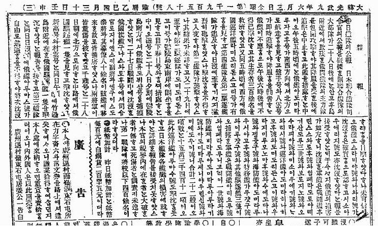
日艦隊의 公報 日本聯合艦隊司令官의 公報를 槪據한 則
聯合艦隊의大部隊가二十八日後에는 안고후 附近에셔敗殘한俄國艦隊의 主力部隊를包圍攻擊하야 其降服을 受한 後에 追擊은 中止하고 此艦을 措處하는中이오
・・・・・・・・・・・・・・・・・・・・・・・・・・・・・・・・・・・・・・
The official dispatch of Japanese fleet. According to the general official dispatch of Japanese fleet, that is, A big unit of the Combined Fleet, after 28th, near the "Angohu(Yanko= Liancourt)" island, encircled and attacked the main force of defeated Russian fleet. And followed by the surrender of the enemy, they stopped the pursuing and in the middle of dealing with the ship...

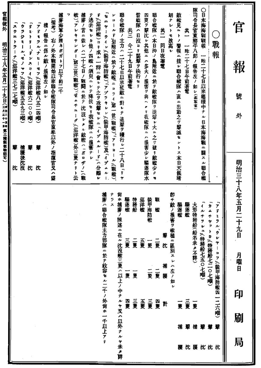
The original Japanese Navy's war report was written under the name of famous Fleet Admiral Marquis Togo Heihachirou (東郷平八郎) and it was printed in official gazette(官報). Korean journalist mainly quoted article no.5 of the original. The original itself starts with the famous phrase "本日天気晴朗 ナレドモ浪高シ" written by Vice Admiral Akiyama Saneyuki (秋山真之). To follow is the part which coincides with the sentence above.

(官報原文 : Original - Official Gazette of Japan

連合艦隊ノ大部ハ、前ニ電報シタル如ク、一昨二十八日午後、「リアンコルド」附近ニ於テ、敗残敵艦隊ノ主力ヲ包囲攻撃シテ、其降伏ヲ受ケ、追撃ヲ中止シ、之ガ處分ニ従事中、
・・・・・・・・・・・・・・・・・・・・・・・・・・・・・・・・・・・・・・
(As it was already transferred, the most of Combined Fleet had encircled and attacked the main force of remaining enemy ship corps defeated near at the Liancourt Rocks in the afternoon on 28th and after their surrender, it stopped the pursuing and now engaging the dealing with the aftermath. )

* Korean reporter mistranslated "大部" as "大部"

* Korean reporter mistranslated "二十八日後" as "
二十八日後"
* "リヤンコルド(Liancourt Rocks)" is translated as "안고후" and altered "rocks" to "island" in Korean article.

1905 0602 皇城新聞

Korean reporter seems to have translated article no.5 of Japanese Navy report basically, but actually, if you read the whole article, you will notice that he/she edited the original and had put more information they got from somewhere else since some parts of them were not in the original Japanese naval report. In other words, although writer did translated the Japanese report, he/she had collected more information and re-organized this article in his/her own perspective.

Interestingly and importantly, the writer of this article used "안고후(Angohu)島(island)", which was common name of the Takeshima/Liancourt Rocks (ヤンコ : Yanko-to)by Japanese and used by Korean as well around early 1900s, instead of "안고후(Angohu)岩(Rock)", the direct translation of the "リアンコルド(Liancourt)(Rock)" in the original Japanese war report. In other words, the writer changed the name of the island into the name it commonly known by. It is the concrete evidence that the writer of the article actually identified the island in concern is Liancourt Rocks(Yanko-to(ヤンコ島)), not only copied the name of the island, and also he/she knew that the island played the important role in the battle of the Tsushima.

Moreover, the reporter wrote Liancourt Rocks as "안고후島", which is the Korean pronunciation of "Liancourt Rocks", not "Dokdo(独島)", "Seokdo(石島)" nor "Usando(于山島)", all of which Korean claim as the other names of Takeshima/Liancourt Rocks. Japanese started to call Takeshima/Liancourt Rocks, which they used to call "Matsushima(松島)" in Edo era, as "Yanko(Liancourt)" island after Meiji restoration in 1867 when they got to know that the western name of the island on the map. And it is known that Korean, in 1904 warship Niitaka report, had wrote the island "Yanko-to/안고후島"(Liancourt Rocks) as "独島(Dokdo)". This 1905 article is important Korean own evidence that Korean still called Takeshima Liancourt Rocks as "Angohu-island", just like Japanese called Yanko-to.

And lastly, in Admiral Togo's original report, notice that he/Navy officers still used "リアンコルド岩(Liancourt Rocks)" instead of "竹島(Takeshima)" which they had already officially incorporated into Japanese territory and renamed as it is four months ago. Apparently, for Japanese officials, Navy, especially Admiral Togo and his brains had not placed much importance on incorporation of Takeshima from the strategical point of view. This implies Navy Captain / A chief of Hydrograhical Department, Kimotsuki Kaneyuki(肝付兼行) had no intention of "secretly" incorporating the island when he advised Japanese fishermen that the island had not been occupied by any other countries and it should be Japanese territory, in September 1904, unlike Mr. Naito Seichu and Prof. Hosaka keep claiming falsely without any concrete evidence.

These points confirm the fact that Korean in 1905 didn't consider Yanko-to/Liancourt Rocks/Takeshima/Dokdo as their own territorial island. And it also excludes the Korea's illogical claim that Japanese incorporation in 1905 was done secretly for the purpose of the accomplishment of Russo-Japan war. In fact, Japanese Navy started to construct watchtower on Takeshima/Liancourt Rocks in July and they started to use it in August, not before, but "after the Japan-Russo War.

During those days in 1903-1905, there were absolutely no newspaper article, official reports, requests, inquiry nor claims which object Japanese (Navy/civilian) activities on Takeshma/Lincourt Rocks from Korean at any level, including this article, which called "Angohu島", not Dokdo. It was not until Shim, the head of Ulleungdo mistook "Dokdo" as their territory, probably mysterious "Usando" which is believed to be 100-ris(40km) away from Ulleungdo, and reported the incident to his boss in mainland, which lead Korean central government require the survey of "the geography and population" of the island. This happened after he was told that Takeshima was now Japanese island, by the delegate group of Shimane prefecture who visited to Ulleungdo in 1906. If Takeshima/Dokdo had been truly their "inherent territory" and had "effective control" over the island in/before 1905 as Korean government currently claim, why they didn't even notice/claim about those open and spectacular war activities on /around Takeshima/Angohu島 by Japanese Navy, like they did about on Ulleugndo? In addition, civilian fishermen including Nakai built the huts and were hunting salions at least from 1903 and Korean definitely knew about Japanese economical activities. But still, there is absolutely no trace that Korean set any claim on them. Why?

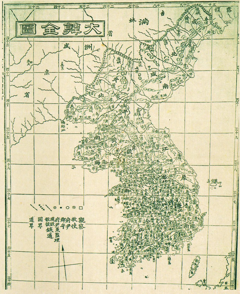
I think it was simply because Korean, especially government officials in Seoul had no accurate nor precise information about Takeshima/Liancourt Rocks at all in the first place and didn't consider over Ulleugdo as Korean territory and thought Jukdo, the modern name of Usando, for the eastern limit of Korea, excluding this "Angohu Island/Liancourt Rocks/Yanko-to" from their territory in 1905. In 1882, Lee Gyu-won used the same name "竹島" with Japanese for Jukdo after Japanese MOFA identified Jukdo as 竹島(竹嶼) in 1881 based on Navy's survey. Although Korean had no accurate information on the whereabouts of Japanese Matsushima, they had simply swallowed the phrase "Usando is Japanese Matsushima",the lie Ahn Yong-bok started in 1696, and kept recording the phrase in the documents. Making the issue complicated, for Korean, Usan(Usanguk/Usando) was the name of Ulleungdo in ancient times. Moreover, Choson people hadn't visited Ulleungdo often since it was prohibited by the dynasty and the voyage was extremely dangerous for them, so they were not perfectly sure about the location of Ulleungdo and Usando and if those islands are two islands or one island with two names until 1711, when Bak Chang-seok's (朴昌錫) inspected Ulleungdo and labelled Jukdo as so-called Usando (鬱陵島圖形). After 1711, in most cases, Ulleungdo started to be recognised as it is today and Usando had been depicted as the neighbouring island of Jukdo(竹島 : Japanes pronunciation = Takeshima), but the Ahn's false calim still kept cited without any doubt in the documents. When they noticed that new Takeshima/Liancourt Rocks was old Matsushima in 1906, which they believed to be Usando, they again started to get confused as if Takeshima(Liancourt Rocks/old Matsushima) was Usando, which was the Korean name for Jukdo. However, in July that year, Korean Ministry of Interior officially answered Takeshima/Liancourt Rocks/Dokdo is outside of Uldo(Ulleungdo) County to the Japanese Resident-General . It is apparent that Korean had no recognition of Takeshima/Liancourt Rocks as their territory until 1950s. I believe Korean government are making use of this chain of misunderstandings and the confusion of names/locations of the islands which Korean had long held from ancient times.

In conclusion, from this article and the original Japanese Navy report, we are safely to conclude that Korean in 1905 did not have even slightest idea/recognition that Liancourt Rocks(Takeshima) was their territory. And the Korean claim that Japanese Navy secretly incorporated the island into Shimane for the purpose of the war is nothing but just a groundless accusation.

The basic idea of this post, writing of Japanese report and Korean article, Japanese translation of Korean article and the detailed analysis of whole report/article, all of them were done by our frequent commentator matsu. Though matsu translated and analysed whole article/report, I have to confess that I couldn't translate all of it. And the article itself was introduced by another commentator GTOMR. Thanks, guys !!


1905 0529 官報号外 Adomiral Togo(東郷平八郎)'s report_11905 0529 官報号外 Adomiral Togo(東郷平八郎)'s report_2_21905 0529 官報号外 Adomiral Togo(東郷平八郎)'s report_3
Reference :

1656 - "Yojiji (輿地志)" by Ryu Hyung-won (柳馨遠) didn't say "Usan is so-called Japanese Matsushima."

1692-1693 - The 1692 and 1693 incidents: Ahn Yong-bok's(安龍福) first visit to Japan

1693-1696 - The Takeshima incident(竹島一件): the 1st dispute between Japan and Korea

1696 - Ahn's so-called Matsushima/Usando was Jukdo, afterall. (元禄九丙子年朝鮮舟着岸一巻之覚書 肅宗実録 30卷, 22年 戊寅)

1711 - Bak Chang-seok's (朴昌錫) Map of Ulleungdo (鬱陵島圖形)

1774 - Chungwanji (春官志): "Ulleungdo is called Sambongdo (三峯島)" ( "盖 是島 以其産竹也 故 謂 竹島 以有三峯也 故謂 三峯島 至於 于山 羽陵 蔚陵 武陵 礒竹 皆音 轉 訛而然 也" )

1881 - Kitazawa Masanari(北澤正誠), a official of MOFA concluded that "Takeshima" is Jukdo in "A Study of Takeshima (Takeshima Kosho 竹島考証) "

Lies, Half-truths, and Dokdo Video, Part 5 : "The King, Lee Gyu-won & Many Names for a Neighboring Island"

Korean Eastern limits described in various books exclude Takeshima/Dokdo from KoreanTerritory

1905 - January 28th: the decision to incorporate Takeshima in to Shimane by a Cabinet meeting公文類集第29編 竹島編入閣議決定)

22.9.08

Kim Jang-Hoon bought maps

According to the Joon-Ang Ilbo (中央日報), a Korean popular singer Kim Jang-Hoon(キム・ジャンフン) got two Japanese antique maps at an auction at 6,500,000 Won, which he would like to give to a museum.
http://japanese.joins.com/article/article.php?aid=105035&servcode=700&sectcode=750
One is 新訂地球万国方図(1854) which labeled Japan Sea as "朝鮮海 (Korean Sea)" and another one is 三国接壌之図(1785) by Hayashi Shihei. As to the latter, the newspaper mentioned "Dokdo and Ulleungdo were coloured green which shows Korean territory".


But the map in the article was not 三国接壌之図 but 朝鮮八道誌(朝鮮八道之図) by the same geographer Hayashi Shiei. Ulleungdo was labeled as "Ulleungdo Usanguku", which was not a proof of sovereignty of Dokdo. Pro-Korean people once claimed "東" in the map shows that Japan Sea was called as 東海 (Tong-he) in Japan too but it was a big mistake - the word 東 (east) was only written to show a point of the compass. http://toron.pepper.jp/jp/take/jpn/hakken.html


20.9.08

1899 Report of Ulleungdo by Japanese warship Maya

This is a report of Ulleungdo by the Lieutenant Junior Grade of Navy (海軍中尉)Furukawa of a warship Mayadated September 27th, the 32nd year of Meiji (1899). It was almost the same period as the Hwangseong Sinmun (皇城新聞) article “Ulleungdo Situation (鬱陵島 事況)” on September 23rd 1899.

http://dokdo-or-takeshima.blogspot.com/2008/04/hwangseong-sinmun-1899-sep-23-ulleungdo.html

http://dokdo-or-takeshima.blogspot.com/2008/05/1899923.html


The information in the report was mainly from a man from Shimane prefecture Amano Genzo who had lived there for 5 years. There is no particular interesting mentioning in the report, it referred to the circumference of Ulleungdo as 13-ri (52km) and it also mentioned that it lacked in flat places because of steep mountains. It said that there were 500 Korean families with population of about 2,000 while Japanese population was only about 100. It was 150 until May or June that year. The place where the many Japanese stayed was 東洞 (Todong), where 15 families with 30 people lived. At 南陽洞 (south part of Ulleungdo) there were four families with seven people and at 通亀尾 (south part of Ulleungdo) three families with 9 people. According to the Hwangseong Sinmun article, Korean population was 300 families and Japanese population was about 200. It is interesting that Korean overestimated Japanese population and Japanese overestimated Korean population.


The report said that Korean people dwelt next to the land they cultivated themselves so their houses were scattered, they only formed 8 village communities. It also said that Korean people were full-time farmers, cropping soybeans but some village communities had a few little ships and some of them did fishing and hunting but the catch was not so large (僅少ノ漁猟ヲナスモノアリト云フ).


As to the Island Supervisor (島監) 裵季周, the report mentioned that he lived at 東洞 and that he was a good-natured man who could understand Japanese language. He was appointed to the post four years before and he visited Japan and inspected Tsuruga and Matsue during one year from May 1898 until May 1899. There had been another Island Supervisor before but he was disliked by villagers for some reasons and was expelled.


17.9.08

North Korean Stamp of Dokdo

This is a stamp of Dokdo made by North Korea (date of issue not known). It shows an old map of Usando - it is apparent that North took the same mistake as South did...

15.9.08

1906 - "Daehan Jiji" (大韓地誌) by Hyeon Chae (玄采)


The Daehan Jiji (大韓地誌 -대한지지) was a 2-volume set of Korean elementary school geography books written by Hyeon Chae (玄采 - 현채) that were published in 1899 and republished in 1906. The picture on the left shows the covers for a 1906 version.
The forward was written by Lee Gyu-hwan (李圭桓), who was in charge of the Editorial Department in the Korean Ministry of Education in 1899. In both the forward, and the postscript, written by Hyeon Chae (玄采), it said the author used Japanese geography texts and Korea's Dongguk Yeoji Seungram (東國輿地勝覽 - 동국여지승람) as references.
All together there are fourteen sections in the 2-volume set. The first section is a general introduction that includes information on the location and size of Korea. The remaining thirteen sections deal with Korea's thirteen provinces, and there is a map of each province at the beginning of each section. There was also supposed to be a full map of Korea at the front of the book published by Korea's Ministry of Education, but I did not find the map in the 1906 version found online at the Korean National Library Web site.
The map to the right is supposed to be the "Daehan Jeondo" (大韓全圖 - 대한전도) from the 1899 version of the Daehan Jiji.
The 1906 version of the Daehan Jiji seems to have been just a reprint of the 1899 version without any updates. For example, Ulleungdo was not shown as a county in either version, even though the island was made a county of Gangwon Province in 1900.
The book is important in the Dokdo-Takeshima debate partly because the coordinates given for Korea in the introduction excluded Liancourt Rocks (Dokdo), but it is mainly important because the map for Gangwon Province shows Ulleungdo with a neighboring island labeled as "Usan" (于山 - 우산).
Koreans claim that Usando (于山島 - 우산도) was the old name for Dokdo (Liancourt Rocks), but the shape and position of the Usan island on this map shows that it was almost certainly Ulleungdo's neighboring island of Jukdo (竹島 - 죽도), which is only about two kilometers off Ulleungdo's east shore. The full map of Korea also showed Usan (于山 - 우산) as Ulleungdo's neighboring island of Jukdo, which is especially important since that map was made by Korea's Ministry of Education.
The following is my translation of the section of the book giving Korea's position and area, including its longitudes and latitudes.
Section 1: Introduction
Chapter 1: Location, Width, & Coastline
Our Daehan state is located on the eastern part of the Asian continent. We are a peninsula state that protrudes out from the northeastern portion of China between the Sea of Japan and the Yellow and Bal Seas (黃海 渤海). Our northern latitude begins at 33 degrees 35 minutes and reaches to 42 degrees 25 minutes. Our eastern longitude (based on the Greenwich Observatory in England) begins at 124 degrees 30 minutes and reaches to 130 degrees 35 minutes.
The east borders the Sea of Japan; the west borders the Yellow Sea; and the south borders the Sea of Japan and the Yellow Sea. The southeast faces Japan’s Daemado [Tsushima] with one strait in between. The north borders the area of the two Chinese provinces of Jilin and Shengjing (支那의 吉林盛京兩省). The border is drawn by Mount Baekdu and the Duman River. One corner between the Duman River in the northeast borders the Russian territory of “Josori” (鳥蘇里).

The area [of the country] is essentially 82,000 square English miles. The length from the northeast to the southwest is about 3,600 ri. The width is irregular in several places. Sometimes it is about 1,000 ri, and sometimes it is 600 or 700 ri.

-----------------
第一篇 總論

第一課 位置 幅員

我大韓國位置는 亞細亞洲東部에 在하니 支那의 東北部로부터 日本海와 黃海 渤海 間에 突出한 半島國이라 北緯三十三度十五分에 起하야 四十二度二十五分에 至하고 東經 (英國錄威司天臺를 據함이 타) 百二十四度 三十分에 起하야 百三十度三十五分에 至하니 東은 日本海를 界하며 西는 黃海에 濱하고 南은 日本海와 黃海에 臨하며 東南은 一海峽을 隔하야 日本對馬島와 相對하고 北은 支那의 吉林盛京兩省과 壤을 接하야 白頭山과 豆滿江으로 境을 劃하며 東北一隅는 豆滿江을 隔하야 露領 鳥蘇里에 接하묘 幅員은 面積이 大約八萬二千方英里오 長은 北東으로 西南에 至함이 三千六百餘里오 廣은 到處에 不齊하야 或 千餘里 或六七百里오
The following is from the chapter on "Bays and Islands" from the Gangwon Province section of the book.
Chapter 3: Bays & Islands

East of this district, the coastline is quite long, but irregularities in the bays and capes are few. With one glance, one can see that it is wide open with no bays or islands blocking the view, so it is called the northeast desert sea (東北沙海).

East of Dongcheon (通川) is Nanpo (蘭浦). East of Ganseong (杆城) is Cape Gajin (加津岬). North of Uljin (蔚珍) is Cape Yongchu (龍湫岬). That bay is called Cape Jukbyeon (竹邊串).

Uljin-po (蔚珍浦) is a wharf east of Uljin. The southern tip that protrudes out into the sea is Cape “Begaesil” (베개실岬). The water is deep inside the bay, making it convenient to anchor boats. Weolsong-po [越松浦 (Pyeonghae - 平海)] is a port at the southern end [南竢 should be 南端?] of this province where it is also convenient to anchor, making it a place where ships regularly come and go.

Songdo (松島), Sado (沙島), Murodo (無路島), Jeodo (猪島), and Jukdo (竹島) are part of a group of islands that line the coast, but they are all small sand or gravel islets. Ulleungdo (獨鬱陵島) is the only fairly large island in the East Sea. In the center of the island is a peak called “Jungbong” (中峯). Its forrest is lush with such sought-after trees as zelkova (規木) and juniper (香木).

---------------
第三課: 海灣, 島嶼

本府東方에 沿岸이 深長하나 海灣岬角의 凹凸함이 少하고 又一望 開豁하야 海灣島嶼의 蔽遮함이 無하니 此를 東北沙海라 稱하느니라.

通川東에 蘭浦가 유하고 杆城東에 加津岬이 突出하며 蔚珍 北에 龍湫岬이 有하니 其海灣은 竹邊串이라 名하니라.

蔚珍浦는 蔚珍東에 在한 埠頭니 其南端의 海에 突出한 者는 베개실岬이라 灣內가 水深하야 繋舟하기 便하고 越松浦 (平海)는 本道 南竢에 在한 一浦니 亦 碇 *하기 便한 故로 舟楫이 恒常 來往하느리라.

沿岸에 松島 沙島 無路島 猪島 竹島 等의 羣島가 羅列하나 皆 渺小한 沙磧地오. 獨鬱陵島는 東海에 在한 稍大島라 島中央에 在한 一峯을 中峯이라 名하니 樹林이 鬱蒼하고 規木과 香木 等이 著名하니라.
The following is the map of Gangwon Province from the 1906 book.


Other Korean Geography Books:

1917 Map of Korea 朝鮮地図


This map, 朝鮮地図, was made by 朝鮮総督府 - the office of Governor-General of Korea in 1917, the 6th year of Taisho (大正6年). Although Liancourt Rocks were already incorporated 12 years before (1905) and Korea was already annexed 7 years before (1910), this map is still interesting.


Pro-Korean scholars are always saying that Japan "annexed" Liancourt Rocks which were originally Korean islands as a preliminary annexation. But if their insistence were correct and Japan robbed Korean islands, the islands should have been included in the "Map of Korea". However, actually Liancourt Rocks were not included in this map. These rocks were not recognised as Korean land from the beginning.
[Click the map to enlarge]


・・・・・・・・・・・・・・
・・・・・・・・・・・・・・
・・・・・・・・
・・・・・・・・
Ulleungdo is labeled as 欝陵島. There are names of 中峰 (the name of a mountain) and 道洞 (Dodong). It seems that there was a line (ship route) from the bay of 竹辺(竹邊) - 迎日湾欝陵島線. Ulleungdo which had been an island of 江原道 in the past was now within the jurisdiction of 慶尚北道.
[Click the map to enlarge]


・・・・・・・・・・・・
・・・・・・・・・・・・
The flipside of the map is a kind of guidebook called "A guide to recent Korea (最近朝鮮案内)". According to the "guide", population of Korea was as follows: 内地人 (Japanese) 320, 938 with 90, 350 families, Koreans 16, 309, 179 with 3, 072, 092 families, Foreigners 18, 012 with 4920 families.

13.9.08

1953 Daiichi-Daihou Maru Incident - the dispute over the Rhee Syngman Line

The ROK President Rhee Syngman suddenly drew a line called Rhee Syngman Line in January 1952 - it was 3 months before the Peace Treaty was to be effective. It was an illegal act from the viewpoint of international laws.


After this occasion, various problems occured. It was the beginning of the dispute over Liancourt Rocks (Takeshima/Dokdo). Among them, the Daiichi-Daihou Maru incident was one of the important incidents. However, there were already miscllaneous frictions appeared before the incident.

[Background: Attacks by Korean warships in 1952]

At 3:00 am on October 13th 1952, when 40 Japanese fishing boats including a fishing boat from Shizuoka prefecture called “Hokoku-Maru” were engaging in fishing squads within Japanese territorial waters at 30 miles east of Udo of Chejudo (Quelpart), three small warships of Korea suddenly machine-gunned them shooting tracer bullets.

And on both of 13th and 14th October, Japanese fishing boats including “Narita-Maru” and “Fukuei-maru” (both from Chiba prefecture), and four other fishing boats from Shizuoka prefecture were attacked by three Korean warships twice at around 20 to 30 miles southeast of Udo. At 11:00pm on October 16th, “Sunami-Maru” of Kanagawa prefecture was attacked by Korean warships at 30 miles east of Chejudo.


And in February 1953, the incident occured.


(The newspaper article at left: February 20th 1953, Asahi Shimbun -courtesy of chaamiey)
[The article said that Japan protested against Korea after revealing that it was an illegal shooting in the open waters.]


To follow is the details of the Daiichi Daihou Maru Incident in 1953:


At 7:00am on February 4th 1953, when two 57-ton fishing boats from Fukuoka, “Daiichi- Daihou Maru” and “Daini-Daihou Maru”, were engaging in fishing at the fishing area #284 which was 20 miles off Chejudo, two Korean fishing boats approached them from the southwest direction. They were called as “第一昌運号” and “第二昌運号” and they asked Japanese ships in Japanese, “How about today’s catch?” The two Korean ships passed Japanese ships and stopped for a while.

When the “Daiichi Daihou Maru” began to draw up fishing nets, a Korean ship that stayed 30 meters behind the stern of the Japanese ship began to shoot with automatic rifles. The two Japanese ships tried to run away but the “Daini Daihou Maru” was captured at 8:15am and the “Daiichi Daihou Maru” gave up to escape because of fierce shooting. The Korean fishing boats were pretending to be private fishing boats but they were heavily armed, Korean military police and navy officers were on the ships. The chief fisherman, Seto Jujirou (or Shigejirou), 34, was shot by the head and lost consciousness. The “Daiichi Daihou Maru” was captured at 8:30am and was ordered by men of the 第一昌運号 to go to 翰林面 of Chejudo. Japanese fishermen were then handed over to a police station, almost all the valuables in the ships including private properties were confiscated by the Korean police.

Japanese fishermen told the Korean Military Police officers that there was an injured. The injured chief fisherman was brought to a small clinic called 高医院 (clinic), but the doctor at the clinic said “No hope” and rejected to treat him. The fishermen asked police to bring him to a larger hospital but policemen said “We only worked by orders of military authorities, it is not our fault” and did nothing. So the Japanese fishermen asked the Military Police once again to bring him to a hospital but the chief of the Military Police said “He is wounded by a bullet which lodges in his head, so he won’t be survive” and did nothing. They repeatedly asked and finally, the chief fisherman was to be admitted to a military hospital. Korean officers said “A car will come soon”. The fishermen asked the clinic to give him an intravenous drip infusion until he was hospitalized but the doctor refused it because it was expensive. A fisherman promised the doctor to pay the bill after selling his private things, and the injured was given a drip infusion. But after all, Korean authority didn’t set a car for the injured. They left him unattended, he died at 11:00pm on February 6th.

On the next morning, his body was dissected to examine the cause of his death and to determine whether the bullet was shot by Military Police officers or by navy officers. It was a bullet shot by the Military Police. They asked the authority to arrange the cremation but their plea was ignored. The fishermen sold the rest of their private properties and held a funeral service for him. They cremated the body gathering pine woods next day.

The fishermen were confined at a room in an air-defense crew room near the police station on February 9th. The room was so small for 18 people, its extent was only about four futon mats. Foods were not given, so they had to eat the rest of the foods which they managed to bring from their ships. On examination, Korean authority insisted that they captured the Japanese ships at the sea 9 miles from 翰林. However, Japanese fishermen pointed out the inconsistency between the time difference of compass of Korean ships and the velocity of the ships. Then, Korean authority proposed to take the middle of their opinions – 13 miles and forced the fishermen to sign the document.

However, according to the radio operator of the “Daini-Daihou Maru”, they were captured at 30 miles from翰林.

When they were sent to Cheju (North part of Chejudo) on February 12th, they noticed that they didn’t have the chief fisherman’s ashes. They asked to bring the ashes but the head of the police station rejected the request. They were moved to the section 2 of the inspection department of Cheju Police Station (済州警察査察課第二係) and were jailed at 11pm without meals.

The Korean Police made a report in hanglu that mentioned the Japanese fishermen violated territorial waters of Korea and forced the fishermen to sign it. While they made the report, they measured a chart with a cigarette and a match along with a ruler, which was an inaccurate measurement.

After it revealed that the ships were captured in open waters, the Commander of Korean Coast Blockade & Escort Fleet - the U.S. Rear Admiral Glitch (spelling unsure) [朝鮮沿岸封鎖護衛艦隊令官グリッチ少将] in Sasebo, Japan, asked for an interview with the President Rhee Syngman. The President Rhee expressed his regret over the incident and the fishermen were released in the end.
[Thanks to Kaneganese for proof-reading]

But this was only one of the incidents. Many of the captured fishermen were detained for 3 or 4 years. Their fishing boats were confiscated and re-used as Korean fishing boats. 3929 of Japanese people were arrested, 328 of Japanese ships were seized, and casualty was 44 of Japanese.

In July 1954 Korea began to occupy the island. To follow is from a newsclip of the New York Times, July 31, 1954. This is how the illegal occupation of Liancourt Rocks by Korea began.

Japanese sources said today the South Koreans had seized
and occupied the Takeshima islands in the Sea of Japan. Title to the islands
long had been in dispute between the two nations.


Two Japanese patrol boats cruising near Takeshima saw a
half-dozen Koreans at work on Mishi Island [sic], one of two rocky islets that make up
the Takeshima group.


The men were uniforms of white shirts and green trousers.
Apparently they were guards sent by the Republic of Korea to enforce the claim
to Takeshima, the Japanese maritime Safety Board reported. It was not apparent
whether the men were armed, the report said, but they evidently intended to stay
on the island.


A large tent had been pitched on what looked like a
permanent foundation, coast guardsmen said. And on the northern side of Mishi a
large sign had been erected with the legend, "Republic of Korea, Seventh
District, Civil Administration Department".


The Japanese made no attempt to land, according to the
Maritime Board, but patrol boats circled the island, broadcasting through their
public address systems that the islands were Japanese territory. To this the
Koreans appeared to pay no attention.


The Japanese visit was made Wednesday by two patrol
ships, the Kuzuryu and Nagara. The Koreans, the Japanese assumed, had been in
posession at least since July 25, the date inscribed on the
signboard.


The Japanese deduced that the Koreans' presence was not a
temporary stop-over, such as is sometimes made by fishermen at
Takeshima.


No Korean vessel was in the vicinity, according to the
Japanese coast guards, leading to the belief the South Koreans had been embarked
on the island with supplies to last sometime.


Takeshima, lying at about Lat. 37 degrees 7 minutes N.
and Long. 131 degree 55 minutes E., consists of two islands, Nishi, the west
island, and Higashi, the east island. Earlier this month, the South Korean
Assembly in a formal proclamation asserted soverignty over both islets and a
party of Assemblymen was reported to have sailed from Pusan this week to inspect
the territory.


The islands have been a bone of contention between Japan
and the Korean Republic since the San Francisco Peace Treaty of Sept.8, 1951,
restored independence to this nation.


The rocky barren islets, which cover only few square
miles, have served as a useful temporary base for fishermen trawling in the Sea
of Japan. According to the Japanese Foreign Office, the islands have been so
used by Japanese fishermen for more than 300 years and at one time were known as
Matsushima or Pine Islands. They were formally incoprporated into the Japanese
national territory in 1905.


Takeshima lay on the Japanese side of the "MacArthur
Line", established as a boundary beyond which the Japanese might not go during
the Allied occupation without special consent. Later, however, when President
Syngman Rhee of Korea set up the "Rhee Line", extending Korean territorial
waters far out into the Sea of Japan, the islands fell on the Korean side of the
boundary.


The Japanese Government, though claiming posession of
Takeshima, apparently has not been able to decide, to date, what to do about
Korea's claims. Last year, answering questions in the Diet, Foreign Minister
Katsuo Okazaki told the members it was "clear by the San Francisco Peace Treaty
that Takeshima is an island of Japan." At that time he said he had "not heard"
of the Korean claim and did not believe the issue worth disputing.


Meanwhile, negotiations between Japan and Korea over
reparations, the establishment of regular diplomatic negotiations and other
issues have completely broken down. So far as is known, posession of the islands
has never been formally discussed, though each side has continued to advance its
own claim to the territory.