竹島問題の歴史

27.2.10

1966 - 2月 - 兪鎮午「韓日会談が開かれるまで」(上)『思想界』1966年2月号

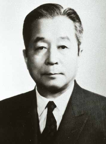
兪鎮午(ゆ ちんご、ユ・ジノ、1906年5月13日 - 1987年8月30日:左の写真_Copyright (c)한국민족문화대백과)は「朝鮮の小説家、政治家。号は玄民。初期はプロレタリア作家、中期は純粋文学、そして後期は親日派として日本の植民地時代を翻弄した。解放後は、韓国において法学者、政治家として活動した。大韓民国憲法の起草者でもある。」人物であるとのことです。(Wikipediaによる)
また、後に日韓の国交正常化交渉の際に、李承晩政権崩壊後の1960年10月から再開された第五次日韓会談の韓国側代表にもなりました。

「一九六〇年四月、李承晩政権が退陣してから、韓国には日本との間に友好親善関係を求める機運が急速に拾頭した。張勉新政権はその施策の重点の一つに日本との国交正常化をかかげ、日韓会談の妥結にきわめて意欲的であった。これに呼応して日本側にもこの機に多年にわたる諸懸案を早急に解決すべきであるとの声が高まった。 かかる情勢の下に、小坂外務大臣は同年九月はじめ、戦後初の公式使節として、韓国を訪問し、鄭外務部長官との間に、日韓全面会談予備会談を開くことに合意した。 かくて第五次日韓会談は日本側から沢田廉三首席代表、韓国側から兪鎮午首席代表をたてて、同年十月から翌年五月まで、約七カ月間にわたって東京において開催された。会談の進行状況は、諸懸案の内包する問題の複雑さと動揺する韓国の国内情勢のため、必ずしも十分満足できるものではなかったが、四月中旬には、あと一カ月で予備会談を打ち切り、その後日韓双方がそれぞれ国内調整を行なった上、九月ごろに本会談を開いて、高度の政治的観点に立った解決をはかるのが適当であると判断されるまでになっていた。 このときに当たり、突如五月十六日、韓国に軍部によるクーデターが発生し、張勉政権が倒れたため、日韓会談はここにまた中絶のやむなきに至った。 」外務省のサイトより)

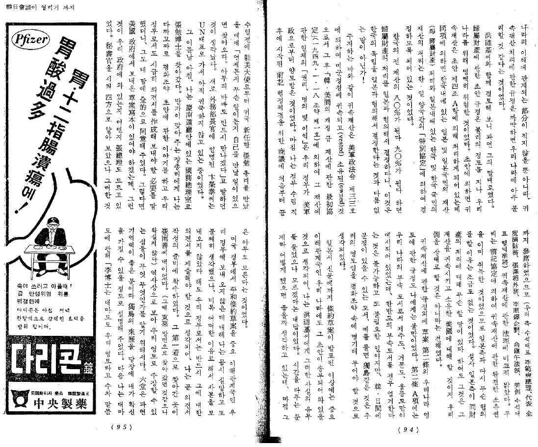
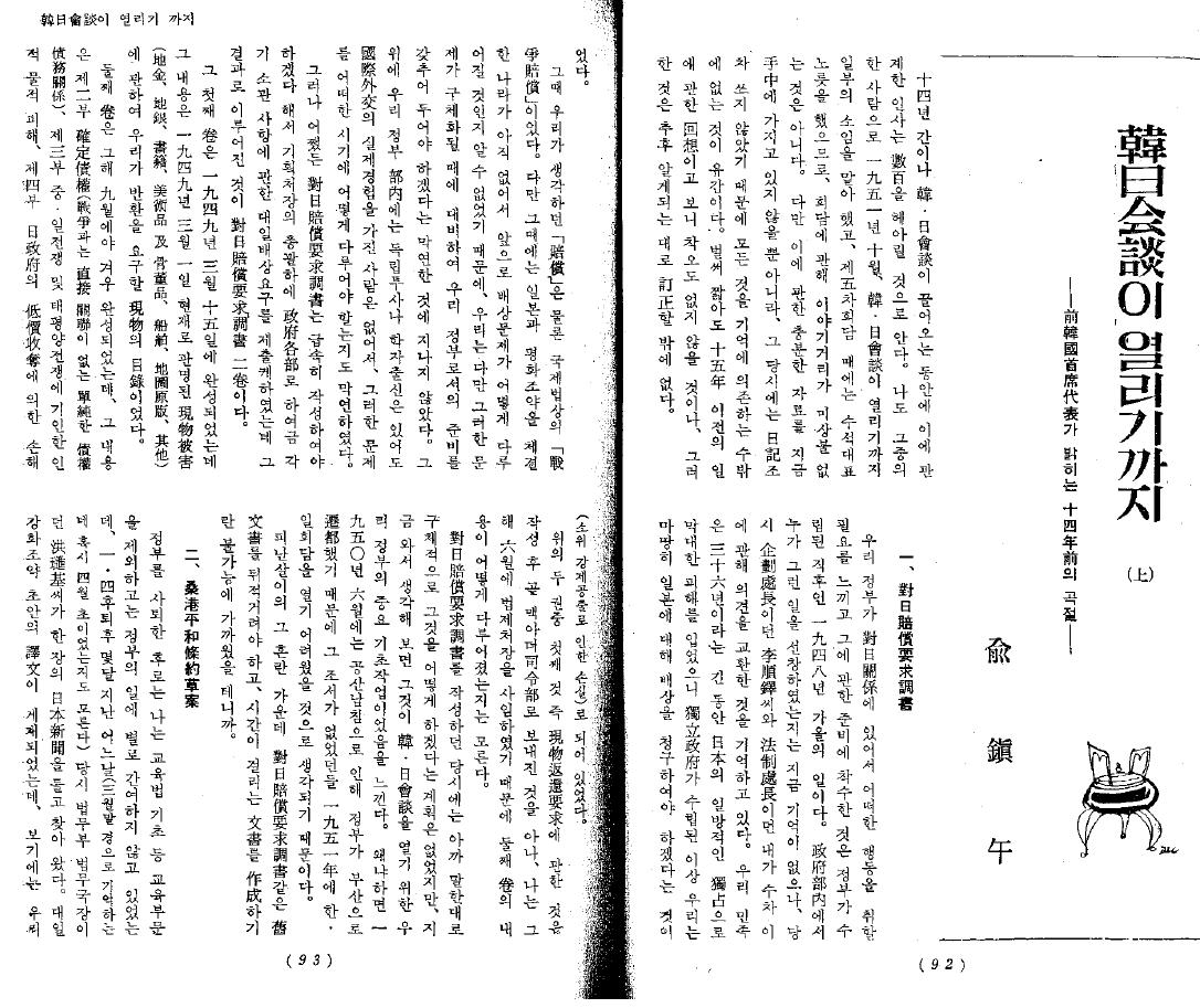
以下は、兪鎮午による回想録である、「韓日会談が開かれるまで」(上下)(韓国の雑誌『思想界』1966年2月号・3月号に掲載された)のうち、"上"の部分のmatsu氏による日本語訳です。(matsuさん、有難うございました。)原文画像を載せましたので、内容とともに皆で検討していきたいと思います。よろしくお願い致します。(なお、文章中に出てくる洪璡基という人は、新聞中央日報の会長だったようです。)

兪鎮午「韓日会談が開かれるまで」(上)『思想界』1966年2月号
―前韓国主席代表が明らかにする14年前の曲折―

14年もの間、韓日会談が続いたために、これに関係した人士は数百を越えるものと思う。私もその中の一人として、1951年10月、韓日会談が開かれるまで一部の責任を果たした。第5次会談の時には主席代表の役割を務め、会談についてはさすがに語るべきことがないわけでもない。しかし、これに関する充分な資料が今手元にない上に、その当時は日記もつけていなかったので、すべて記憶に頼るのみであることが遺憾である。すでに少なくとも15年以前のことについての回想であり、錯誤もあると思うが、それは明らかになった後の訂正を待つほかはない。

一 対日賠償要求調書

わが政府が、対日関係において行動を取る必要を感じ、その準備に着手したのは、政府が樹立された直後の1948年秋のことである。政府部内で誰がそんなことを先唱したのかは今記憶がないが、当時、企画処長であった李順鐸(イ・スンテク)氏と、法制部長であった私が、数次、これについて意見を交換したものと記憶している。わが民族は、36年という長い間、日本の一方的な独占により莫大な被害を受けたが、独立政府が樹立された以上、我々は当然日本に対して賠償を請求しなければならないということであった。
当時、我々が考えた「賠償」は、もちろん国際法上の「戦時賠償」であった。しかし、当時は日本と平和条約を締結した国はまだなく、今後賠償問題がどのように取り扱われるのか不明だったため、我々はただ、そのような問題が具体化される時に備え、わが政府としての準備をしておこうという漠然としたものに過ぎなかった。その上、わが政府部内には独立の闘士や学者出身はいても、国際外交の実際の経験をもつ人間はおらず、そのような問題を、どのような時期に、どのように取り扱うべきかも漠然としたものだった。
しかし、いずれにしても、対日賠償要求調書は急いで作成しなければならないとして、企画処長の総括下に、政府各部をして夫々の所管事項についての対日賠償要求を提出させるようにしたが、その結果として出来上がったのが、対日賠償要求調書の二巻である。
その第一巻は、1949年3月15日に完成したが、その内容は、1949年3月1日現在で判明した現物被害(地金、地銀、書籍、美術品および骨董品、船舶、地図原版、その他)について、我々が返還を要求する現物の目録であった。
第二巻は、その年の9月にようやく完成したが、その内容は、第二部、確定債権(戦争とは直接関連がない単純な債権債務関係)。第三部、中日戦争および太平洋戦争に起因する人的、物的被害。第四部、日本政府の低価収奪による損害(所謂、強制供出による損失)からなっていた。
上の二巻の中の第一巻、すなわち、現物返還要求については、作成後、まもなくマッカーサー司令部に送られたことは知っているが、私は、その年の6月に法制部長を辞任したため、第二巻の内容がどのように取り扱われたのかは知らない。
対日賠償要求調書を作成した当時には、先に述べたように具体的にそれをどうしようという計画はなかったが、今になって考えてみれば、それが韓日会談を開くためのわが政府の重要な基礎作業だったと思う。なぜなら1950年6月には共産南侵のため政府が釜山に遷都したため、この調書が無かったならば1951年に韓日会談を開くのは難しかったと考えるからである。
避難生活の混乱の中で、対日賠償要求調書のような、旧文書を調べなければならず時間のかかる文書を作成することは、不可能に近かっただろうからである。


二 サンフランシスコ平和条約草案

政府を辞職したあと、私は、教育法基礎など教育部分を除けば、政府の仕事には特に関与せずにいたが、1・4後退後、数か月たったある日(3月末ごろと記憶するが4月はじめだったかもしれない)、当時法務部の法務局長であった洪璡基(ホン・ジンギ)氏が、日本の新聞1紙を持ってやってきた。対日講和条約の草案の訳文が掲載されていたが、それを見れば、我が国の利害に関係する部分が少なくないばかりか、帰属財産処理についての規定は、まかり間違えば我が国に非常に不利であるようだとのことであった。
洪璡基氏とともに検討してみると、果たして彼の言うとおりであった。帰属財産についての草案の規定は、不利などころではなく、我が国にとって明らかに危険なものであった。草案によれば、帰属財産は、草案第四条A項により処理されることになっているが、同項によれば、韓国内にある日本および日本国民の財産(すなわち帰属財産)の処理と、日本内にある韓国および韓国国民の財産の処理は、韓日両国間の「特別協定」により決定されることになっていた。
韓国の全財産の80パーセント、90パーセントともなれば、帰属財産の処理を日本と協議して決定するとは、まさに韓国の独立を日本と協議して決定するということと同じことではないか!
周知の通り、帰属財産は、米軍政法令第33号により、米軍政庁に帰属し(vested)所有された(owned)ものであり、その後「韓米間の財政及び財産についての最初協定」(1949.1.18.条約第一号)により、その財産に関する一切の「権利、名義、および利益」は、わが政府が米軍政から譲渡されたものであった。ちょうど私は、政府樹立直後に始まった前記の協定締結のための協議に最初から最後まで参席しており、(我が方の主席代表 李範奭総理、代表 金度演財務、張澤相外務、李順澤企画、兪鎮午法制、米側主席代表 ヘルミック准将)、帰属財産についての法理に比較的明るかった。我が国は、前記協定により、帰属財産についての完全な所有権をすでに取得していたのであり、日本側と改めていかなる協議もするべき理由は少しも無かったのである。たとえ、日本側が同財産の処理について何か言いたいことがあるとしても、それは、その財産を帰属させ、所有した米国に対してなされるべきことであり、我々を相手とすることではないという見解であった。
帰属財産についての規定の他に、草案第二条の、我が国の領土についての規定も私には不満であった。第二条A項には、我が国の付属島嶼として、済州島、巨文島、鬱陵島だけが例示されていたが、韓半島の付属島嶼を全部列挙することは不可能であり、また不必要なことであるが、韓日間の紛争がありうる島嶼、例えば独島のようなものは、我が国の領土であることを平和条約の中に明記しておかなければならないと思われた。
日本で新聞にまで条約草案が発表された以上、重要な利害関係国である我が国にも、その草案が送付されて来ているものと思われ、私は洪璡基氏にそのような事実の有無について訊ねたが、わからないという答えであった。時を争う問題であり、どうしたら良いか考えていたが、ちょうどその数日前に、駐米大使から帰国した新任の張勉総理に会った時に、「いつでも、どんなことでも、私に会うべきことがあれば訪ねて来い。どんなに忙しくても、必ず会う」と言っていたのを思い出した。新たに外務部長に任命された卞栄泰氏は、国連代表として、まだ帰国していない時であった。
その二日後の朝、私は慶尚南道道庁の中にあった国務総理室に張勉博士を訪ねて行った。喜んで会ってくれた張総理に、私はいきなり平和条約草案についての話をし、わが政府としても、急いで意見書を作成して送る必要があると言うと、彼も私の言葉に全く同意してくれた。それならば、米国政府から送ってきた草案の写本があるはずであるが、そのようなものが我が政府に来ているのかどうか、張総理も知らないでいた。秘書官に命じてあちこち調べさせたが、そんなものは誰も知らないということであった。
米国政府から平和条約草案を、重要な利害関係国である我が政府に送って来ていないことに対して私は非常に失望し、また不快に思ったが、たとえ、いかなる理由で写本を送って来ないにせよ、我が政府としては必ずそれに対する意見書を提出しなければならないと考え、私はすぐに意見書作成の準備に着手した。
その第一番にたずねて行った所は、崔南善氏の家であった。(その時、東莱方面にたずねて行ったようであるが、確実ではない)。歴史上から見て、我が領土として主張することが出来る島が、どれとどれであるかを知るためである。六堂(訳注:崔南善の号)は、果たして記憶力が良い方であり、独島の来歴を、即座に、私が確信を持てる程に説明してくれた。次に、私は対馬島について、「李博士は、対馬島も我が国の領土だと何度も言っていますが、根拠が確実ですか?」と訊ねると、六堂は声を立てずに笑って首を左右に振った。ところがそのかわり、六堂は、私に新たな知識をひとつ与えてくれた。我が国の木浦と日本の長崎、中国の上海を連結する三角形の中心となる海中に、「パラン島」という島があるが、表面が非常に浅くて、波の中に埋もれたり、現われたりするということだった。「パラン」というのは、草(プル 水ムルの誤植か?)が青く・・・してする語なのか、波の中に入ったり、現われたりするので「波浪」というのか、確実ではないが、いずれにしても、それは我が国の領土としてこの際に確実にしておくのが良いだろうということであった。六堂の言葉に私が狂喜したことはもちろんである。もし、この島の名前が対日平和条約の中に明記されることになれば、我が国は済州島の西南方に大きく領域を広げることになるのだから。
二三日後、張勉総理から緊急の連絡があって行って見ると、何かの書類を手にして、「もう二週間前に大統領の所に来ていたのに、ある秘書の引き出しの中に今までほうり込んで置いたままにしていたんだそうだ。チッ チッ。(舌打ち音)」と不機嫌に言った。書類は、もちろん、数日前から捜していた、米国政府から送られてきた対日平和条約草案であった。私は、国事をこのように処理することがありうるのか、とあきれて物も言えなかったが、いずれにしても良かったと思い、そのまま草案について洪璡基氏とともに内容を研究・検討しはじめた。

当時、このことについて政府部内で我々に最も理解を示し、協力してくれたのは、金俊淵(キム・ジュニョン)法務部長官であった。彼は、張総理とともに、我々の意見に全面的に同調し、国務会議(閣議)の席上でも、欠席中の外務部長官に代わって我々の意見をおおいに代弁してくれた。
しかし、すぐに我々は難関に突き当たった。張総理、金法務などが、帰属財産についての法理をいくら説明しても、李大統領は、「マッカーサー将軍が私に約束した言葉がある」として、平和条約草案の修正を要請するのに賛成しないということであった。
仕方なく、我々はムチオ大使を動かす努力を始めた。その時、誰がムチオ大使にあったのか確実な記憶が無いが、崔斗善(チェ・ドゥソン)氏などがしたことだと思う。ムチオ大使は、すぐに我々の言うことを理解してくれたそうである。
ムチオ大使が、その後、李大統領に会い、説得を試みたかどうか、私は知らない。しかしいずれにしても、李大統領もわれわれの意見に賛成するようになり、我々は外務部の中に「外交委員会」というものを構成し、我が政府の意見書を作成しはじめた。その時、委員として参席した人は、金俊淵(キム・ジュニョン)法務、崔斗善(チェ・ドゥソン)、裴廷鉉(ペ・ジョンヒョン)、洪璡基(ホン・ジンギ)、李建鎬(イ・ゴノ)、朴在隣(パク・チェリン)、そして私、などであった。
意見書作成にあたって、まず第一に問題になったのは、大韓民国が対日平和条約の署名国の一つとなることを要求するのか、ということであった。もし我が国が平和条約署名国の一つになりさえすれば、我々は日本に対し戦勝国の地位を持つことになり、したがって戦争賠償を受けられるのはもちろん、その他のあらゆる問題について絶対的に有利な位置に立つことになるからだった。しかし、この問題はあまりに政治的であり、また重慶臨時政府時代以来、散発的に何度も論議されてきたことであったため、すでに作成された草案に対する部分的意見書に含ませるにはあまりに重大であったので、大統領の活動に一任することにし、ここには入れないことにした。
意見書は、4、5個の条項から構成されていたが、帰属財産問題と領土問題の他のものが何であったのかは、今は覚えていない。領土問題中、「パラン島」は、実存するかどうかが確実でなく、自信がなかったが、たとえ実存しないにしても、入れておいて害になることも無いだろうとして、独島とともに平和条約第二条に追加するように要求した。
そうしているうちに、卞栄泰(ピョン・ヨンテ)新任外務部長官も帰国して執務するようになり、外交委員会の委員たちとともに意見書作成に協力した。特に、作成した意見書の英訳は、卞長官が直接に専担し、一字一字、精密に検討した。
意見書の英訳まで終えた私は、再び私の仕事(戦時聨合大学のこと、海軍法務監室で米国海軍関係の法典を翻訳すること等)に専心していたが、ある日(いつであったか確実ではないが、6月初め頃ではなかったかと思う)、久しぶりに外交委員会を開くというので出向いたところ、卞外務長官から我が政府の意見書はすでに米国政府に送ったという報告があった。私はとても満足した。しかし、席上で配布された意見書の写本(英文)を見て、私は憤慨した。委員会で作成した意見書に、非常に長い前文をつけ、内容も、1、2項目追加されていたが、その前文なるものは奇怪で、本文で展開した法理論と相衝する(あいいれない)内容であったからだ。誰がこんなことをしたのか、と言うと、大統領顧問である米国人が加筆したものだという答えであった。私は、非常に不快であったが、もうどうすることもできなかった。
それはそれとして、我が政府で意見書を送った結果として、対日平和条約の第四条にB項が追加されたことは、我々の外交の大きな収穫であった。その後、韓日会談を通して我々が骨身に染みて経験したところであるが、新設されたB項に、日本は米軍政庁が帰属財産について行った処分(帰属、所有、およびわが政府への譲渡)の効力を承認すると明示されているにもかかわらず、そのまま、その財産に対して今だに「請求権」なるものを持っていると、止むことなく主張し、何度も会談を決裂させたのであるが、もし、その条項が新説されていなかったならば、どんな主張を持ち出してきたのか分からないのである。
帰属財産についてのことだけが採択され、それ以外の我が政府の意見は、すべて拒否されたことは遺憾なことであった。特に、独島を平和条約の中に明記しなかったことは、長く続く紛争の種を残した処置であった。日本占領軍最高司令部が、当初いわゆる「マッカーサー線」を引く時にも、彼らは独島を「マッカーサー線」の外に置いたのであり(すなわち、日本の漁船が独島まで来る事ができないようにしたのであるが)、ここへ来てそれを平和条約の中に明記しなかったことは、理解することができない処置であった。しかし、そうだとしても、それをもって米国が独島を日本領土と考えているとは、もちろん解釈されない。鬱陵島に付属した小岩礁にすぎないので特記する価値がないものと見た結果にすぎないのである。
パラン島は、その年の夏、韓国山岳会の洪鐘仁(ホン・ジョンイン)氏が主導し、わが海軍の協力のもと、日本海軍水路部で発行した海図を持って実地探査したのであるが、ついに発見できずに終わった。忽忙中、不得意なことであったが、国家の権威を象徴する公式の外交公文書に、実存しない島の名前を書き、我が領土だと主張したことは、取り返しのつかない失敗であった。
そうこうするうちに、政府部内では、韓日会談開催の機運が熟してきた。我が国は、対日平和条約の関係国として、同条約により、請求権、海底電線、漁業、通商航海などの自らの問題を日本と協議・解決するようになっているばかりでなく、日本における僑胞処遇問題、解放後の密入国者の強制送還問題、船舶問題などで、当時すでに駐日代表部とSCAP間で交渉が進行中であり、それがわが国会でも問題になっていたからである。
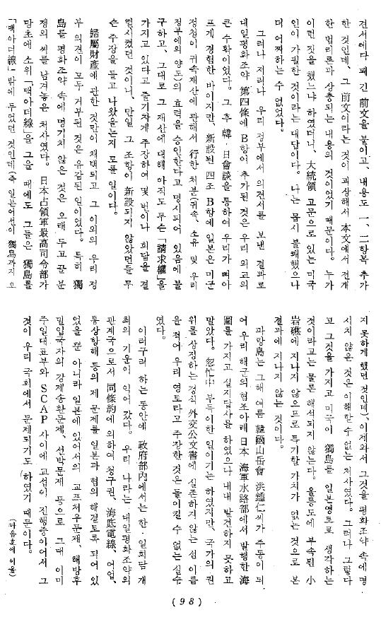
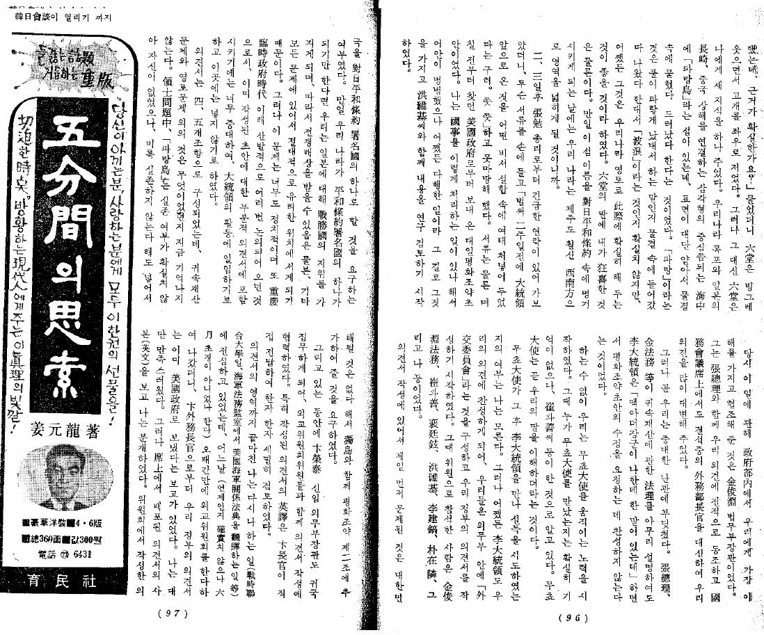
1966 兪鎮午「韓日会談が開かれるまで」(上下)『思想界』1966 2月号・3月号_4 1966 兪鎮午「韓日会談が開かれるまで」(上下)『思想界』1966 2月号・3月号_3 1966 兪鎮午「韓日会談が開かれるまで」(上下)『思想界』1966 2月号・3月号_2 1966 兪鎮午「韓日会談が開かれるまで」(上下)『思想界』1966 2月号・3月号_1

22.2.10

2010 - Feb. 22 - Happy Takeshima Day !!

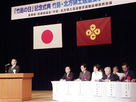
Today, the Shimane Prefectural Government marked its fifth "Takeshima Day(竹島の日)", since its assembly approved an ordinance establishing Takeshima Day in 2005. To my surprise, 10 members of National Diet participated in the ceremony, held in Matsue today, according to Sankei Shimbun. Though none of the official of Ministry of Foreign Affairs nor the Diet member of the ruling party joined, it's a great progress considering it was only 3 of them last year.

2010 - Feb. 22 - "Fifth Takeshima Day ceremony was held in Matsue (5度目の「竹島の日」 松江で記念式典)" (Sankei Shimbun, Japanese) cache

(picture left, by Kimura from Sankei)

Oh, the Korean protesters came to Matsue and had a outdoor protests as always. You can see the usual member in the protest group. Check the video below out. But it looks Korean got less interested in Shimane's Takeshima Day gradually every year in the last 5 years.

2010 - Feb. 22 - Korean protested with the banner(韓国人が横断幕で抗議)"(Kyodo, Japanese)

According to Asahi Shimbun, 90 % of public schools (primary & Junior high schools) in Shimane are going to have the special class for teaching Takeshima this year.

2010 - Feb. 22 -  "Takeshima class" expands to more than 90% schools (広がる「竹島」授業/小中学校9割超で実施)" cache

13.2.10

1600s: "Dongyeo Bigo" (東輿備攷) Maps

The Dongyeo Bigo (東輿備攷) is a Korean atlas that is believed to have been compiled in the late 1600s, though there is an argument that it was made even earlier as a reference for the Dongguk Yeoji Seungram (東國輿地勝覽), which was published in 1486. The atlas has thirty-two maps, including historical maps that were meant to show geographical name changes though history.

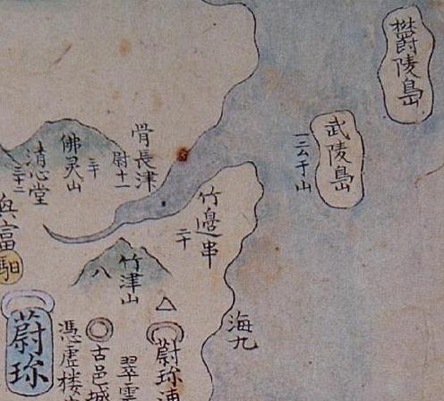
Three of the maps in the Dongyeo Bigo show us how the name for the Korean island of Ulleungdo evolved from "Usando" (羽山島) during Korea's Three Han Period (before 300 A.D.), to "Usanguk" (羽山國) during Korea's Three Kingdoms period, and to Muleungdo/Usan (武陵島/于散) during the early Joseon period. One of the maps even appears to show Ulleungdo's neighboring island of Jukdo labeled as "Ulleungdo" (鬱陵島). Here are the three maps from the Dongyeo Bigo:

"Boundaries during Han's 4 Gun-2 Bu Period" (四郡二府漢時分界之圖)


The above map showed the boundaries of the Korean pennisula around the time of Korea' s Three Han Period (三韓時代), which ended about 300 A.D. The map shows Ulleungdo labeled as "Usando" (羽山島).

Map of Original Regions of Silla, Goguryeo, & Baeje (新羅高勾麗百濟肇造區域之圖)


The above map shows the Korean peninsula during Korea's Three Kingdoms Period, which ended in 668 A.D. The map showsUlleungdo labeled as "Usanguk, now Ulleungdo" (羽山國 今欝陵島), which means Ulleungdo went from being called "Usando" (羽山島) to Usanguk (羽山國).

"Map of the Counties of Gangwondo's East-West Regions - Uljin" (江原道東西州郡棇圖 - 蔚珎)


The above map shows two islands of the coast of Uljin (蔚珎). One island is labeled "Ulleungdo" (欝陵島) and the other is labeled Muleungdo (武陵島), with the phrase "also called 'Usan'" (一云 于山) written beside it.

In the 1400s, Ulleungdo was referred to as "Muleungdo" (武陵島), "Usando" (于山島), and Usan-Muleung (于山武陵). Muleungdo (武陵島) was also used to refer to Ulleungdo's neighboring island of Jukdo (竹島), which is only two kilometers off Ulleungdo's northeast shore. In the 1500s and 1600s, Korean maps showed Ulleungdo labeled as Usando (于山島) and its neighboring island of Jukdo (竹島) labeled as "Ulleungdo" (鬱陵島), though this was probably just confusion about which side of Ulleungdo the neighboring island was. By the end of the 1600s, however, the confusion seemed to have been cleared up because the main island of Ulleungdo was being labeled "Ulleungdo" (鬱陵島) and its neighboring island of Jukdo was being labeled "Usando" (于山島).

The fact that the above map shows both "Ulleungdo" (欝陵島) and "Muleungdo" (武陵島) suggests that it may have represented a time around the start of the 1500s, which was about the time the name "Muleungdo" switched back over to "Ulleungdo." The fact that the map shows the island to the west labeled "Muleungdo/Usan" (武陵島/于山) and the island to the northeast labeled "Ulleungdo" (欝陵島) suggests that, at the time the map was made, Ulleungdo was being referred to as both "Muleungdo" and "Usan" while its neighboring island of Jukdo was being referred to as "Ulleungdo." However, since the "Three Kingdoms Period" map had the phrase "Now called Ulleungdo" next to "Usanguk," we can assume that "Muleungdo/Usan" was referring to Ulleungdo's neighboring island, even though the map showed it to the west of Ulleungdo instead of the east. Nevertheless, the map suggests that Ulleungdo's neighboring island was referred to as both "Usando" and "Muleungdo" during the 1400s. By 1530, the name "Muleungdo" was replaced by "Ulleungdo," based on the following 1530 Korean map, which shows two islands beside each other. The one closer to the Korean coast was labeled "Usando" (于山島), and the one to its east labeled "Ulleungdo" (鬱陵島). The 1530 map below was not part of the Dongyeo Bigo.

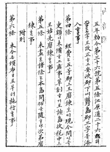
1900 - Oct. 22 - A petition by 李乾夏 "鬱陵島를鬱島로改稱하고島監을郡守로改正에關한請議書", which excluded Dokdo from Uldo County.

3 days before the Ordinance NO.41 was promulgated, the petition for the ordinance was submitted by 李乾夏, a Minister of Internal Affairs of Korea, and it says that "the area of the island in concern(該島地方) should be 80 ris(32km) in length and 50 ris(20km) in the width." As we know, today's Takeshima(Korean call as Dokdo, meaning lonely island) is 92km far from Ulleungdo.

울릉도(鬱陵島)를 울도(鬱島)로 개칭(改稱)하고 도감(島監)을 군수(郡守)로 개정(改正)에 관(關)한 청의서(請議書)

우해도(右該島)가 동명(東溟)에 특립(特立)하야 대륙(大陸)이 원격(遠隔)온바 개국오백사년(開國五百四年)에 도감(島監)을 설치(設置)하야 도민(島民)을 보호(保護)하고 사무(事務)를 관장(管掌)케 해도감(該島監) 배계주(裵季周)의 보첩(報牒)과 본부시찰관(本部視察官) 우용정(禹用鼎)과 동래세무사(東萊稅務司)의 시찰록(視察錄)을 참호절사(參互節査)하온즉 해섬지방(該島地方)이 종가팔십리(可八十里)오 횡위오십리(橫爲五十里)라. 사위초벽(四圍壁)에 중유거산(中有巨山)하야 자북지남(自北止南)하고 간유대천(間有大川)하야 탐광(深廣)이 기용주즙(幾容舟楫)하고 기토(其土)가 옥유(沃)하고 기민(其民)이 질야(質野)하야 자수십년래(自數十年來)로 민축(民蓄)이 번식(蕃殖)하야 호수(戶數)가 위사백여가(爲四百餘家)오 간전(墾田)이 위만여두락(爲萬餘斗落)이라. 거민(居民)의 일년농작(一年農作) 담포수효(擔包數爻)가 저위이만여포(藷爲二萬餘包)오 대맥(大麥)이 위이만여포(爲二萬餘包)오 황두위일만여포(黃豆爲一萬餘包)오 소맥(小麥)이 위오천포(爲五千包)라 오니 대률(大率) 호수(戶數)와 전수(田數)와 곡수(穀數)를 육처(陸處) 산군(山郡)에 교계(較計)오면 수혹불급(數或不及)이오나 불심상좌(不甚相左) 더러 만근(挽近) 외국인(外國人)이 도래교역(徒來交易)하야 교제상(交際上)도 역유(亦有)하온지라, 도감(島監)이라 칭호(稱號)하오미 행정상(行政上)에 과유방애(果有妨碍)기로 울릉도(鬱陵島)를 울도(鬱島)라 개칭(改稱)하고 도감(島監)을 군수(郡守)로 개정(改正)하타당(妥當)기 이에(此段) 칙령안(勅令案)을 회의(會議)에 제정사(提呈事)

광무사년(光武四年) 십월이십이일(十月二十二日)

의정부찬정내부대신(議政府贊政內部大臣) 이건하(李乾夏)

의정부의정(議政府議政) 윤용선각하(尹容善閣下) 사조(査照)

--------------------------------------------

鬱陵島を鬱島と改称し、島監を郡守と改正することに関する請議書

  右該島は東溟に特立し大陸から遠隔であるが、開国504年に島監を設置して島民を保護し事務を管掌させており、島監裵季周の報牒と本部視察官禹用鼎、東萊稅務司の視察錄を參互節査したところ、該島地方は縦が八十里ほど、橫は五十里という。
 四圍壁の中に巨山があって北より南に至る。その間に大川あり、広さ深さは舟を幾つか容れることができ、その土は肥沃で民は素朴であり、この数十年、人口は蕃殖し、戸数は四百余戸あり、墾田は万余斗落ある。
  居民の農作一年の収量は、藷二万余包、大麦二万余包、 黃豆一万余包、小麦五千包という。大まかに戸数、田数と穀数を陸地の山郡と比較すれば、数は及ばないが甚しく劣るものでもない。
  最近、外国人が来て交易し、交際上のことも有り、島監と称するのでは行政上の障害もあるため、鬱陵島を鬱島と改称し島監を郡守に改正するのが妥当であるので、この段、勅令案を会議に提出する。

光武四年十月二十二日

     議政府賛政內部大臣 李乾夏

議政府議政 尹容善 閣下 査照

(chaamieyさんによる仮訳)

Three days later, based on this petition, Ulleungdo was promoted as Uldo County, one of the county of Gangwon Province by the Ordinance no. 41. This petition itself was made based on the inspection led by U Yong-jeong(禹用鼎) in June 1900, 4 month prior to the petition, while he didn't even hint about today's Takeshima in his report. From those Korean official documents, it is apparent that Seokdo(石島) in the ordinance is not today's Dokdo/Takeshima/Laincourt Rocks at all. There is absolutely no trace of today's Takeshima in those series of documents nor maps made by Korea.

In that sense, it is significant that皇 城新聞 reported that (the Korean Interior Ministry answered to Japanese Resident-General) "area under the authority of the Uldo County were sixty ris(24km) from east to west and forty ris(16km) from north to south for a total of 200 ri s(80km)", Because Ms. Yu had to make it clear how 禹用鼎, who was the official inspector from Interior Ministry, recognized the area of Uldo County, since 禹用鼎 was the one who inspected Ulleungdo in June 1900 and suggested that Ulleungdo to be promoted to the "Uludo County". The suggestion by 禹用鼎 actually lead to the promulgation of the Imperial Ordinance No.41.

However, the fact is, 禹用鼎's inspection area was limited to "the circumference of 140-150 ris(56-60km)", which is clearly Ulleungdo alone. This area clearly included Jukdo(竹島) and Sokdo(石島) as the petition by the Minister of Interior 李乾夏 stated as "The area of the island in concern(該島地方) should be 80 ris(32km) in length and 50 ris(20km) in the width.", the petiotion was submitted a day before the Imperial Ordinance was issued. Besides, the reason 禹用鼎 defined Ulleungdo as "the circumference of 140-150 ris(56-60km)" is that he followed the definition by Lee Gyu-won(李奎遠), who was sent to inspect on Ulleungdo in 1882 by the order of Kojong(高宗), that Ulleungdo is "the circumference of 140-150 ris(56-60km)." Their geographical recognition of Ulleungdo reflect on the map "欝陵島外図" by Lee, who was ordered to draw the precise map of Ulleungdo by Kojong. The map "欝陵島外図" depicted Jukdo(竹島, Japanese name 竹嶼) and Do-hang(島項), and it made the range of Ulluengdo, which is supposed to be "the circumference of 140-150 ris(56-60km)" clear. (10th column of Prof. Shimojo Masao)

--------------------------

This is strongly supported by the petition which was submitted by 李乾夏, a Minister of Internal Affairs of Korea, 3 days before the Ordinance NO.41 was promulgated. Since it specified Ullengdo, which later became Uldo County, has "80 ri(32km) in length and 50 ri(20km) in width" and its special products are "potatoes, barley, soybeans and wheat." In those years, major industries on Ulleungdo were agriculture and fishery were extremely as minor as harvesting seaweeds around on the shore around Ulleungdo. This is also proved by the report of inspector U Yong-jeong(禹用鼎) in June 1900, which lead Ulleungdo promoted as one of the county of Gangwon Province 4 months later. In his report "Uldo-gi(鬱島記)", U wrote that "its agricultural products were barleys, wheats, soy beans and sweet potatoes." and "fisheries were mainly harvesting seaweeds." As we can clearly see from this, on Ulleungdo in 1900, agriculture was the residents' legitimate occupation, while fishery were only for harvesting seaweeds. Islanders on Ulleungdo only started to voyage to Takeshima/Dokdo when they were hired by Japanese fishermen who began hunting sealions in earnest on Takeshima/Dokdo, which was 4 years after the Imperial Ordinance were promulgated.

Moreover, the area which U inspected was limited to "the circumference 140-150 ris (56-60 km)(周廻一百四五十里)", which means the area was Ulleungdo alone and he didn't go to Takeshima/Dokdo at all. This is because, for Korean, the territorial sphere for Ulleungdo were already established as InspectorLee Gyu-won(李奎遠), who inspected Ulleungdo in 1883, had already wrote that Ulleungdo has "the circumference 140-150 ris (56-60 km)(周廻一百四五十里)". Then Lee defined neighboring islands of Ulleungdo as 竹島(Jukdo) and 島項( It was later changed to "鼠項島", whose pronunciation resembles to "Seokdo" very much. ) altogether and those two are small islands within 2km or so from Ullgungdo. ((16th column of Prof. Shimojo Masao))

If Korean really wants to claim this Seokdo(石島) was today's takeshima, she needs to prove their theory with concrete evidence based on first-hand historical source, not speculation.

Whatever the Seokdo in the Imperial Order no.41(大韓勅令第41号 ) was, it was absolutely not today's Takeshima/Dokdo/Liancourt Rock. That's for sure.

1900 鬱陵島를 鬱島로 개칭하고 島監을 郡守로 개정하는 건에 대한 請議書_勅令案(勅令第41號鬱陵島를 鬱島로改稱하고島監을郡守로改正하는件)_21900 鬱陵島를 鬱島로 개칭하고 島監을 郡守로 개정하는 건에 대한 請議書_勅令案(勅令第41號鬱陵島를 鬱島로改稱하고島監을郡守로改正하는件)

References;
The 10th column
" A Blunder of Sokdo(石島) = Dokto(独島) Theory

The 16th column ""Dokdo Month" without any historical grounds."

1882 April 7 - King Kojong says Usando Neighboring Island of Ulleungdo (高宗 19卷, 19年 4月 7日 壬戌)
1900 - Imperial Edict Makes Ulleungdo a County of Gangwon Province (大韓勅令第41号)
1906 - Feb 20 & April 17 - "Official Documents of the Ministry of Internal Affairs Vol.1" - Korean government protested about land transaction in 竹邊浦
1906 - July - Korea Omits Dokdo from Uldo County (皇城新聞 「鬱島郡의 配置顛末)
Investigation of Japanese maps during Meiji period before the incorporation of Liancourt rocks
Korean Eastern limits described in various books world wide exclude Takeshima/Dokdo from Korean Territory
The Territorial Recognitions which Western Maps of Japan Show for Takeshima/Liancour Rocks between 1880-1905 : Ver.1

12.2.10

Three Kingdoms Map from 1600's

The following map is entitled "Map of the Original Regions of Silla, Goguryeo, & Baeje" (新羅高勾麗百濟肇造區域之圖) and is from an atlas entitled "Dongyeo Bigo (東輿備攷)," which is believed to have been compiled sometime in the mid to late 1600s. The map below is one of thirty-two maps in the atlas, which is believed to have been made to aid in the understanding of "Dongguk Yeoji Seungram" (東國輿地勝覽) . The atlas is stored at Daeseong Hermitage (大成庵) in the South Gyeongsang Province city of Yangsan (梁山). The map is very similar to THIS MAP.

The map shows an island off the east coast labeled "Usan-guk - Now Ulleungdo" (羽山國 今 陵島). This is evidence that Usan-guk was just a reference to Ulleungdo and did not include "Dokdo" (Liancourt Rocks).

11.2.10

Korean Finally "Discovers" 1905 Japanese Newspaper Article

Korea's Maeil Economics newspaper reports in a February 9, 2010 article that a Korean professor has discovered a 1905 Japanese newspaper article reporting Japan's incorporation of Takeshima (Dokdo). The Korean article, entitled "Japanese Empire, Dokdo's Seizure Announced Domestically through Newspaper," quotes Professor Kim Mun-gil (金文吉) of Busan Foreign Language University (see photo) as saying the following:

"Recently, I have discovered evident in Japan's Shimane Prefecture Library that the Japanese government tried to inform its people, by way of newspaper, of its incorporation of Dokdo as Japanese territory."

"최근 일본 시마네현 도서관에서 일본정부가 독도를 일본영토로 한다는 사실을 신문을 통해 국민들에게 알리려고 했다는 증거를 발견했다."

The 1905 Japanese newspaper article that the Korean professor has only "recently discovered" is the same article that we wrote about on this blog in 2007. If he had only come HERE and read our post three years ago, the professor could have "discovered" the article much sooner.

Koreans have been claiming for years that the Japanese government in 1905 tried to keep the incorporation of Takeshima a secret, supposedly because Japan did not want the world to know that she was stealing Korean land. Now, in an article that is trying to make some kind of news out of the fact that the Japanese article referred to Takeshima as "Oki's new island," Koreans are inadvertently admitting that the incorporation of Takeshima was made public in 1905.

By the way, the 1905 Japanese article was entitled "Oki's New Island" (隠岐の新島), not "Japan's New Island." The title only meant to say that Takeshima was officially put under the jurisdiction of Oki County, not that it was a new Japanese island, which is what the Korean article seems to be trying to imply.

Land, especially a few barren rock islets, can be considered a part of a country's territory without being put under the administration of a local government. For example, the United States and other countries have what are now called "unincorporated, unorganized territories." Before its incorporation in 1905, Takeshima seems to have been considered such a territory by Japan, as this 1877 letter from an official of Japan's Ministry of Foreign Affairs suggests. Here is an excerpt from the 1877 letter:
Many records say that “Argonaut,” which is the Western name for Takeshima (Ulleungdo), does not exist, and that “Dagelet,” which refers to Matsushima, is actually Takeshima (Ulleungdo). So what we call "Matsushima” (Liancourt Rocks) is called “Hornet Rocks” by Westerners. Foreign maps show Hornet Rocks to be Japanese territory, but there is still no agreement among countries concerning the other two islands.
Japan has many old maps showing Takeshima as Japanese territory, but Korea has none showing it as Korean territory. Takeshima before 1905 appears to have been considered unincorporated Japanese territory, but in 1905, it was formally incorporated, as is evident by the 1905 Japanese article mentioned above.

Thanks, Kaneganese, for pointing out the Korean article.

5.2.10

I do not support Korea's "East Sea" movement.

Today, I got an E-mail from someone asking me to include the name "East Sea" next to "Sea of Japan" in my "Purpose of this Blog" introduction. I refused by responding as follows:

I do not support the Korean movement to rename the "Sea of Japan" to the "East Sea," just as I would not support a movement to rename the "Gulf of Mexico" or any other standardized geographic name. Why make geography more confusing than it already is?

I see Korea's "East Sea" movement as a nationalistic, anti-Japanese movement. If it were not anti-Japanese, then Koreans would be pushing equally as hard to change the name "Yellow Sea" to the "West Sea."

Koreans may not realize it, but their campaign to change the name of the Sea of Japan looks pretty silly to the rest of the world, and I would advise them to stop it.
I may reconsider my stance when I start seeing a majority of Korea's Web sites and maps using the name "Sea of Japan" alongside the name "East Sea."

4.2.10

"Rie Akiba angers Korean netizens with Dokdo"

According to THIS ARTICLE, Korean "netizens" are angry at Rie Akiba over a comment she made about "Dokdo." Rie is the Japanese member of a panel of foreign women that are featured on a weekly Korean talk show. The women are asked their opinions on a variety of topics generally concerning Korea. The women respond in Korean with varying degrees of fluency.

Rie said that when she is asked her opinion on "Dokdo," she usually dodges the question by turning it around and asking the questioner his or her opinion, instead. She also asks why he or she has that opinion and where the questioner got the opinion.

The best answer Rie could have given would have been, "I don't want to talk about Dokdo," but the second best answer was probably the one she gave because if a foreigner gives an opinion different from the Korean opinion on Dokdo, the foreigner is generally crucified in Korea. If Rie had not said anything more about Dokdo, I think she would have been all right, but she added the following:
I have actually done some research on Dokdo. Korea first found it, but I cannot say for sure which country it belongs to. Korean people first found it, but the first people to name it were the Japanese.
First, there is no evidence to suggest that Koreans were the first to find "Dokdo." All the evidence shows that the Japanese were the first to both find and name the island, which was first named "Matsushima" and later "Takeshima." Second, there are maps and documents proving that the Japanese were visiting "Dokdo" (Takeshima) as far back as the 1600s, but Korea has no evidence of Koreans visiting the island before the Japanese started taking them there on Japanese fishing boats in the early 1900s. Also, the Korean name for the island, "Dokdo," does not appear before the early 1900s.
If Rie had really researched the isssue, then I cannot understand how she could come to the conclusion that Koreans were the first to find Dokdo. Did she use Korean or Japanese sources? Is the history really that poorly explained in Japan?
I wonder if Rie really believes that "Dokdo" (Takeshima) was first found by Korea or if she only said that in a failed attempt to be diplomatic and avoid crucifixion?
Another member of the talk show panel, Canadian Dominique Noel, defends Rie Akiba against Korean netizens on her Web site. See HERE.