 ”Geography Text of Kangwon Province (江原道誌)” was first published in 1940, while Korea was under Japanese Annexation. I'm not sure if the text was written by Japanese or Korean, but it was written in old Chinese (漢文), which was very rare in Japan in 1940s. Though it was published years after Japan's incorporation of Takeshima into Shimane in 1905, it still shows many interesting points.
The most important point in the text is that it clearly states that "Ulleungdo can be seen from Ulgin", Choson peninsula, not "Usando from Ulleungdo" like pro-Korean insist. In addition, it states Ulleungdo locates at the 135° 5′ E, which seems to be the mistake of at the 135° 55′ E, which is the Eastern longitude of Jukdo(竹島). ( Jukdo(竹島) was included in the section of "山川(Mountains and Rivers)", but not Dokdo, Usando nor Seokdo or any other name Korean claim as other names for Takeshima/Dokdo.)
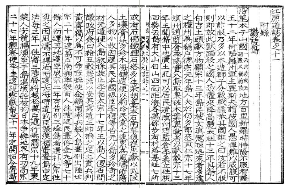
江原道誌 巻之十一 附録 鬱陵島
・・・
〔位置及地勢〕 在蔚珍郡竹邊港東北海中三峰岌業撑空 南峯稍卑 風日清明 則峰頭樹木及山根沙渚 歴歴可見風便則二日可到全島絶壁周囲層岩峻急作三角形河川清冽原野雖少火山灰及腐植土甚肥沃距竹邊七十六浬東経一百三十度五分北緯三十七度三十分面積七千三百五十一町
------------------------------------------------
The Geography Text of Kangwon Province, Vol.11. Appendix Ulleungdo
・・・
(Location and Geography) It locates in the Northeastern sea of 蔚珍(Uljin)郡竹邊 harbour. Three peaks reach high into the sky. The southern peak gets gradually smaller. On clear, windy days, the trees on the summits and the sandy beaches at the base of the mountains are clearly visible. With a fair wind, they can be reached in two days. The whole island was surrounded by steep cliffs and covered by layers of rocks. The shape of the island is triangular. The clear rivers are running through the wild fields. Though there are not so much volcanic ashes and leaf molds, the land is fertile. It is 76 sea miles apart from 竹邊. It locates at the 135° 5′ E and 37° 30′ N. They have an area of 7351 cho (72.9 k㎡).
Actually, there is no mention of Usando at all in the sentence unlike other old documents, this time. So they are undoubtedly talking about the visibility of Ulleungdo from peninsula, that's for sure. It flatterly debunks Korean claim that the distance being talked about in the passage below from Geography Text of Korea's King Sejong (1454) was the distance between the two islands (Ullegungdo and Usan) rather than the distance between Uljin and the two island. The Korean translation is simply wrong if you read whole text.・・・
〔位置及地勢〕 在蔚珍郡竹邊港東北海中三峰岌業撑空 南峯稍卑 風日清明 則峰頭樹木及山根沙渚 歴歴可見風便則二日可到全島絶壁周囲層岩峻急作三角形河川清冽原野雖少火山灰及腐植土甚肥沃距竹邊七十六浬東経一百三十度五分北緯三十七度三十分面積七千三百五十一町
------------------------------------------------
The Geography Text of Kangwon Province, Vol.11. Appendix Ulleungdo
・・・
(Location and Geography) It locates in the Northeastern sea of 蔚珍(Uljin)郡竹邊 harbour. Three peaks reach high into the sky. The southern peak gets gradually smaller. On clear, windy days, the trees on the summits and the sandy beaches at the base of the mountains are clearly visible. With a fair wind, they can be reached in two days. The whole island was surrounded by steep cliffs and covered by layers of rocks. The shape of the island is triangular. The clear rivers are running through the wild fields. Though there are not so much volcanic ashes and leaf molds, the land is fertile. It is 76 sea miles apart from 竹邊. It locates at the 135° 5′ E and 37° 30′ N. They have an area of 7351 cho (72.9 k㎡).
于山武陵二島 在縣正東海中 二島相去不遠 風日淸明 則可望見 新羅時 稱于山國 一云鬱陵島. 地方百里
-----------------------------------------------------
The two islands of Usan and Mu-leung are in the sea due east of the present "hyeon" (Uljin), and the distance between them is close enough that they are visible on a clear, windy day. In the time of Silla, they were called Unsan-guk or Ulleungdo. It has an area of 100 ri.
This is also supported by almost all other Korean old documents which states about the visibility of Ulleungdo. For example, Sinjeung Dongguk Yeoji Seungram (新增東國輿地勝覽) (1530) also states that the islands of Usando/Ulleungdo (于山島 鬱陵島) were visible from the east coast of Korea. The text is almost same with Geography Text of Kangwon Province(1940), though Usando was described as same island as well.
Second point is, it states that the early immigrants are mainly from 江原慶尚両道, not 全羅南道 as some pro-Korean claim.于山島 鬱陵島 一云武陵 一云羽陵 二島在縣正東海中 三峯岌嶪撑空 南峯稍卑 風日淸明則峯頭樹木 及山根沙渚 歷歷可見 風便則二日可到 一說于山鬱陵 本一島 地方百里---------------------------------------------------------------------------
Usando/Ulleungdo are also called Muleung (武陵) or Uleung 羽陵). The two islands are in the sea due east of this village (Uljin). Three peaks reach high into the sky. The southern peak gets gradually smaller. On clear, windy days, the trees on the summits and the sandy beaches at the base of the mountains are clearly visible. With a fair wind, they can be reached in two days. It is said that Usan/Ulleung were originally one island. They have an area of 100 ri.
〔沿革〕 ...(高宗)三十一年定開拓令置島長自是江原慶尚両道沿海民多移住者光武四年改為鬱陵郡置郡守隆煕元年移属慶尚南道併合後大正三年移属慶尚北道四年改郡守為島司 --------------------------------
(History) ... In the year of 31 (of King Kojong)(1894), the order of development was issued. The head of island was appointed and coastal residents of both 江原 and 慶尚 province mainly immigrated. In the 4th year of 光武(1900), it was determined as Ulleungdo County and the County Magistrate (郡守) was appointed. In the first year of 隆煕(1907), the administration was moved to 慶尚南道, and after the annexation, it was again moved to the 慶尚北道 in the 3rd year of Taisho(大正)(1914). And the "County Magistrate" was changed to "Island Magistrate(島守)".
(History) ... In the year of 31 (of King Kojong)(1894), the order of development was issued. The head of island was appointed and coastal residents of both 江原 and 慶尚 province mainly immigrated. In the 4th year of 光武(1900), it was determined as Ulleungdo County and the County Magistrate (郡守) was appointed. In the first year of 隆煕(1907), the administration was moved to 慶尚南道, and after the annexation, it was again moved to the 慶尚北道 in the 3rd year of Taisho(大正)(1914). And the "County Magistrate" was changed to "Island Magistrate(島守)".
Thirdly, it states that Usan was an old name for Ulleungdo. This is the only opportunity the name of "Usan" was mentioned in the text. "Usan" or "Usando" had been actually a name for Ulleungdo itself until Joseon Dynasy started to send official inspectors and gained more information around Ulleungdo in the late 1600s. Before that, Korean were not perfectly sure if there even really exit two islands. After the inspection, Inspector Bak Seok-chang (朴錫昌) made the map of Ulleungdo (鬱陵島圖形) 1711 and placed Usando(=Jukdo) right east to Ulleungdo with a label, "So-called Usando, Grove(s) of Haejang Bamboo (所謂于山島 海長竹田)". It crystellized the conception that Usando was Jukdo, 2.2 kilometers off the east shore of Ulleungdo and almost all the Korean maps started to place Usando to the east of Ulleungdo. Before that, the location of two islands were confusional and "Usando" and Ulleungdo were recorded to be one island with different names / Two different islands in many Korean old documents. This historical coufusion remains even in official documents for a long time.
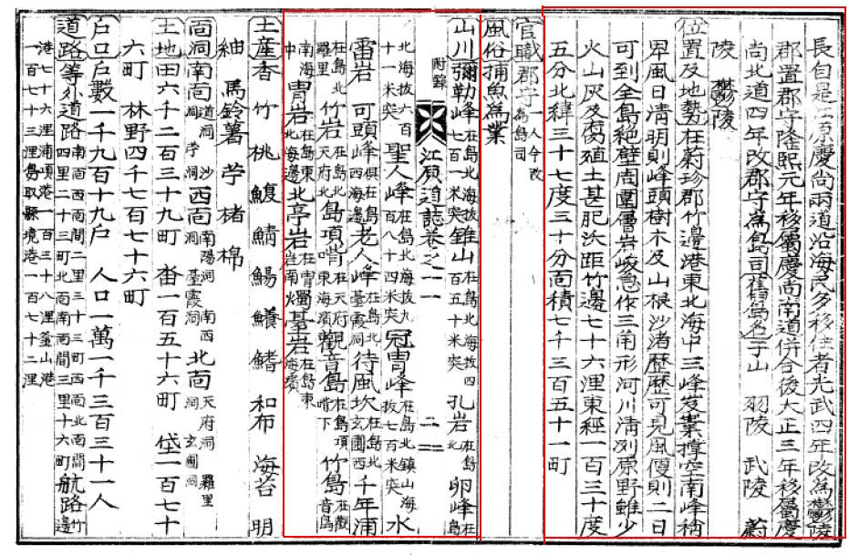
〔舊(古)島名〕 于山 羽陵 武陵 蔚陵 鬱陵
---------------------------------------------------------
(Old Name of Uleungdo) Usan, Ulleung, Mulleung, Ulleung, Ulleung
---------------------------------------------------------
(Old Name of Uleungdo) Usan, Ulleung, Mulleung, Ulleung, Ulleung
Lastly, as I already mentioned above, though the text mentions 観音島 and Jukdo(竹島/竹嶼) in the section of "山川(Mountains and Rivers)", but not Dokdo, Usando nor Seokdo or any other name Korean claim other names for today's Takeshima/Dokdo.
〔山川〕弥勒峰 在島北海抜七百一米突 錐山 在島北海抜四百五十米突 孔岩 在島北 卵峰 在島北海抜六百十一米突 聖人峰 在島北海抜九百八十四米突 冠冑峰 在島北鎮山海抜七百米突 水雷岩 可頭峰 倶在島西海邊 老人峰 在島北台霞洞 待風坎 在島北玄圃西 千年浦 在島北羅里 竹岩 在島北天府北 島項嘴 在天府東海濱 観音島 在島東海濱
---------------------------------------------------------
(Mountains and Rivers) Maitreya(弥勒) peak locates at the north of the island with 701m of the sea level. A Gimlet Mountain locates at the north of the island with 450m of the sea level. 孔岩 locates at the north of the island. Egg peak locates at the north of the island with 611m of the sea level. A Saint peak(聖人峰) locates at the north of the island with 701m of the sea level.
After the name "Usando" started being officially dropped from Jukdo and the name of Jukdo, Ulleungdo's neighboring island, which is only 2 kilometers off Ulleungdo's east shore, was officially recorded as Jukdo(竹島) by inspector 李奎遠 in 1882, right after Kitazawa Masanari(北澤正誠), a Japanese official of MOFA concluded that "竹島(Takeshima)" is Jukdo in 1881, "Usando", the old name for Jukdo, somehow started wondering again among Korean residents on Ulleungdo and they lost the location of "Usando".
This confusional naming shift around 1900 gave space for today's Korea's illogical claim "Usando was an old name for today's Takeshima/Dokdo", not Jukdo nor Ulleungdo, in addition to the name confusion by Japanese in Meiji due to the introduction of mismapped two Uleungdos in western maps, plus Japanese' newly giving Liancourt Rocks a name of Takeshima(竹島), which is the same Chinese as Korean Jukdo. But if the name "Usando" really didn't mean Jukdo, Korean in early 1900s must have named other islets around Ulleungdo or Takeshima/Dokdo as Usando, but they didn't, in reality. It practically means Usando didn't mean any other islets around Ulleungdo, except for Jukdo. Korean gave Takeshima/Liancourt Rocks, which Japanese introduced them in 1900s, a new name "Dokdo(独島)", which means "Sole/Lonely island", instead. The meaning of the name itself debunks Korea's claim that the Takeshima/Dokdo have been considered to be Ulleungdo's neighbouring island.
Those historical facts also tell us that Usando was almost certainly the old name for Jukdo(竹島 : Japanese write as 竹嶼), not today's Takeshima/Dokdo.
A lots of thanks to GTOMR for showing this important document.
References;
Q 2: What is Ulleungdo's largest neighboring island?
Q 3: Why did old Korean maps show Ulleungdo as two islands?
Q 4: Did King Sejong's geography text mention Dokdo?
Q 5: Did Korea's 1530 "Sinjeung Dongguk Yeoji Seungram" mention Dokdo?
1694 - Jang Han-sang (張漢相) Finds Sambongdo (三峯島)
1711 - Bak Chang-seok's (朴昌錫) Map of Ulleungdo (鬱陵島圖形)
1807 - May 12 - Lee Tae-gun (李泰根) Inspects Ulleungdo (日省録)
1881 - Kitazawa Masanari(北澤正誠), a official of MOFA concluded that
"Takeshima" is Jukdo in "A Study of Takeshima (Takeshima Kosho 竹島考証) "
1882 - April 7 - King Kojong says Usando Neighboring Island of Ulleungdo (高宗 19卷, 19年 4月 7日 壬戌)
1906 - July - Korea Omits Dokdo from Uldo County (皇城新聞 「鬱島郡의 配置顛末」)
1913 - June 22- Location of Usando Unknown in Early 1900s (毎日申報 "無人島探検中止")
If anybody know how to spell Chinese Character "雖の口がム", please let me know. Thanks.
ReplyDeleteThanks Kaneganese, this is another evidence to show that Usando was not Liancourt Rocks.
ReplyDelete「雖の口がム」はまだ見つかりませんが、代用字のネット検索では:
ReplyDelete虫部
(飲の欠が虫)→蝕
(雖の口がム)→雖(雖もある)
と「雖」が代用字になっているようです。
その漢字は、文字鏡フォントでは、042086番にあります。
ReplyDeleteしかし、unicodeでは、存在しません。
もっとも、「口」が「ム」になっている文字は、雖の異体字ですから、
「雖」と表記して、何の問題もありません。
pacifistさん
ReplyDelete小嶋日向守さん
ありがとうございます。「雖」に差し替えます。
Kaneganese様
ReplyDelete参考に:
高宗31年はおそらく1893年(高宗は1863年から1897年まで帝位についていたので、31年目は1893年になるため)
光武4年は同じく1900年か(1897年~1907年帝位のため)
隆熙元年は1907年。
間違っていたらごめんなさい。
Interesting document, but it seems older than 1941. How do you know it was written in 1941? Could it have just been copied from an earlier text and simply published in 1941?
ReplyDeleteAnyway, what I found interesting, for some reason, were the placenames listed HERE.
Thanks, pacifist
ReplyDeleteI was too lazy to calculate them... BTW, According to this site, 高宗31年 seems to be 1894年. Others looks right. I'll add the information.
Gerry,
I only copied what GTOMR said. I have to ask him if he is sure about the year when the book was published. According to Kwangwon Province's official site, ”江原道誌 ” was first published in 1940. So the book should be no earlier than 1940. But the information ni the text are old as in 1910s. So it is very possible that the geographical informations are only copied from what was written in other old documents. In other word, there may be other similar documents exist.
As for the place names, check the map "鬱陵島図 朝鮮総督府(1918) " They are almost coincidental.
Kanerganese様,
ReplyDeleteそうですね、この表でも1894年となっています。
http://www.ioc.u-tokyo.ac.jp/~koreandb/nengou.htm
しかし帝位についたのは1863年12月のようですから、1863年が元年になる筈なのですが実際には1864年を元年と数えていることになります。この時代には実際には中国の元号を使用していて、朝鮮の元号使用は光武からだそうですので対した違いは無かったのかもしれませんが・・・
I don't remember exactly, but I guess I took this text from Kyuujanggak (from Japan it is no possible to access the source "원문") and they said 1941. any1 pls confirm is this text from the link below;d
ReplyDeletehttp://www.nl.go.kr/korcis/search/MokCha.php?rec_key=101213902&title_info=&author_info=&publisher_info=undefined&pubyear_info=undefined
http://www.nl.go.kr/korcis/search/detail_code.php?control_no=OUB2005022154
Thanks, pacifist
ReplyDeleteGTOMR,
I hope someone can get an access to Kyujangaak site and tells us what it says.
Actually, the pdf file GTOMR gave us has printed numbers at the bottom of the pages in addition to old style pages at the middle part. So, probably, the document was only a copy and the book was kind of a collection of those old informations.
1863年の事に関しては、年号を西暦で表していても、十二月という月日を陰暦で示しているという事による、いわば、陰暦と陽暦の違いに起因するのではないでしょうか。
ReplyDelete干支では、癸亥に当たるその年の大部分は、西暦の1863年に当たりますが、陰暦での十二月は、実は陽暦では、とっくに年が明けた、1864年に成りますので、高宗元年は、1864年で良いのだと思います。
小嶋日向守様
ReplyDeleteなるほど、陰暦なら西暦より一ヶ月近く先になりますから確かにそうですね。彼らの暦では年が明けてから帝位に就いたことになるわけですね。
しかし陰暦で元号を使用していたとなると、元号を西暦に直す際に月によっては誤差が出ることになりややこしいことですね。
いずれにせよ、ありがとうございました。
前回の投稿は、私の思い違いであったようです。高宗元年が、1864年であった理由は、
ReplyDelete儒教的な服喪の理念に基づいた、「踰年改元」であったと解釈するべきでした。踰年改元とは、即位の年は先帝への遠慮から旧元号を用いて、実際の改元はその翌年にするというものです。
東アジアの歴史を記述する際に、暦年月日をどう記述するかという問題が生じます。日本史の場合は、例えば、西暦の1863年1月31日に当たる、文久二年十二月十二日を記述する場合には、文久二年(1862年)十二月十二日と記述するのが普通です。同様に、高宗の即位した、西暦1864年1月20日に相当する、文久三年十二月十二日は、文久三年(1863年)十二月十二日と書くわけですが、この括弧内の西暦年号は、その元号年の大部分が相当する年を便宜的に記述しているだけで、決して1862年12月12日や、1863年12月12日と思ってしまってはいけないし、また、こう記述してもいけないと教えられました。しかし、ウィキペディアの記述では平気で陰暦の日付を陽暦のように、1863年12月12日などと無頓着に書かれていましたので、混乱してしまいました。
http://ja.wikipedia.org/wiki/%E9%AB%98%E5%AE%97_(%E6%9C%9D%E9%AE%AE%E7%8E%8B)
日本の天保元年や、弘化元年は、同じように、十二月改元でしたが、踰日改元でしたので同年中の元年となっていました。
すみません、天保と弘化は、即日改元というのが正しいようです。
ReplyDeleteTo Mr gerry
ReplyDeletePlease serch this Ulluengdo records on 1911 .
Especially wanna know the administrative divisions, e.g. South Face, North Face, West face.
and please translate abotu Seal point , Seokpo-dong and so on this newspaper on 1928.09.26
Hi GTOMR,
ReplyDeleteYes, there is a very interesting comment in the 1928 article about Seal Point (可頭峰). Here is my translation of the passage I am especially interested in:
----------------
可頭峰 엽흘도니 通九味 외돌 병풍
이봉에 올라서면 청명한 말에는 조선의 강원도는 물론이오 일본영이 보인다고 해서 일본 사람이 국견봉 (國見峯)이라고 제멋대로 이름을 부쳤다.
On the other side of Gadu-bong (可頭峰) was Tong-gumi's wind screen rock
If you climb to the top of this peak on a clear day, you can see, of course, not only Gangwon Province, but they say you can also see Japanese territory, which was why the Japanese gave it their own name of "Guk Gyeon Bong" (國見峯).
-------------
Of course, the Japan territory being referred to was almost certainly Liancourt Rocks (Takeshima/Dokdo). Since Japanese maps from the 1800s showed Seal Point labeled as 國見峯 (Country Viewing Peak), we can assume that the Japanese still believed Liancourt Rocks to be Japanese territory even in the 1800s.
Thank you Mr Geryy,
ReplyDeletePlease translate more?
・about 水雷巖 at the The sentence of "到処森林鬱蒼 鳥類会場天国"
・about 石門洞 and 南面 and so on at the sentence of "開拓当初移住X八旬老人X伝言"
"水雷巖"on the newspaper 1928.09.26 is shown on the Detailed Ulluengdo map by 朝鮮総督府 on 1917 and 1918. Today, this rock is still exist and prominent?
ReplyDeletefrom digital library1923.朝鮮八道秘密地理誌 李重煥1931全鮮名勝古蹟 慶尚北道鬱陵島 金?東1936.慶尚道誌 李鉉式
ReplyDelete〔沿革〕
ReplyDelete省略
〔位置及地勢〕在蔚珍郡竹邊港東北海中三峰XXX空南峰稍卑風日清明則峰頭樹木及山根沙渚歴歴可見風便二日可到全島絶壁周囲層岩峻急作三角形河川清列原野雖少火山灰及腐殖土甚肥沃距竹邊七十六浬東経一百三十度五分北緯三十七度三十分面積七千三百五十一町
〔官職〕郡守一人令政為島司
〔風俗〕捕魚為業
〔山川〕弥勒峰 在島北海抜七百一米突 錐山 在島北海抜四百五十米突 孔岩 在島北 卵峰 在島北海抜六百十一米突 聖人峰 在島北海抜九百八十四米突 冠冑峰 在島北鎮山海抜七百米突 水雷岩 可頭峰 倶在島西海邊 老人峰 在島北台霞洞 待風坎 在島北玄圃西 千年浦 在島北羅里 竹岩 在島北天府北 島項嘴 在天府東海濱 観音島 在島項下 竹島在観音島南海中 冑岩 在島東北海邊 北芋岩 在冑岩南 燭臺岩 在島東海濱
〔土産〕
香 竹 桃 鰒 鯖 鰑 鱶鰑 鰭 和布 海苔 明紬 馬鈴薯 芋 楮 棉
〔面洞〕
南面 道洞 沙洞 芋洞
西面 南陽洞 南西道 臺霞道
北面 天府洞 羅里洞 玄圃洞
〔土地〕
田六千二百三十九町 水田 百五十六町 垈百七十六町 林野 四千七百七十六町
〔戸数〕
戸数千九百十九戸 人口 一万千三百三十一人
〔道路〕
等外道路 南面西南間二里三十三町西面北面間四里二十三町北面南面間三里十六町
航路 竹邊港七十六浬浦項港百三十八海里釜山港百七十三海里鳥取県境港百七十二海里
〔市場〕
鬱陵一 在道洞毎日開一
〔壇廟〕 省略