竹島問題の歴史

27.5.08

1881 - Kitazawa Masanari(北澤正誠), a official of MOFA concluded that "Takeshima" is Jukdo in "A Study of Takeshima (Takeshima Kosho 竹島考証) ".

After intensive debates inside the Ministry of Foreign Affairs (MOFA), prompted by petitions to develop the so-called island of "Matsushima" (松島), Foreign Minister Terajima Munenori (寺島宗則) finally ordered an on-site survey of Ulleungdo in 1880 and dispatched the warship Amagi (軍艦天城) to the area to clear up the name confusion concerning the islands in the region.

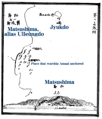
The Amagi discovered that the "Matsushima" (松島) being referred to in the petitions was actually the Korean island of Ulleungdo (鬱陵島), which also had a small island appoximately two kilometers off its northeast shore named "Takeshima" (竹嶼 = 죽서). The map to the left shows Takeshima (竹嶼) to the north of the spot the Amagi anchored off the east shore of Ulleungdo.

Kitazawa Masanari (北澤正誠), of the MOFA (外務省書記官), was ordered to investigate the situation, so he perused the related documents and historical books and wrote an account of this investigation in the "Takeshima Kosho" (竹島考証 - "A Study of Takeshima"). In his account, he concluded that "Matsushima" was Ulleungdo, and that the island that was being called "Takeshima" was Ulleungdo's neighboring island of Jukdo, which is about two kilometers off Ulleungdo's northeast shore. He said that the two islands were not Japanese territory.

Here is a translation of Mr. Kitazawa's findings.
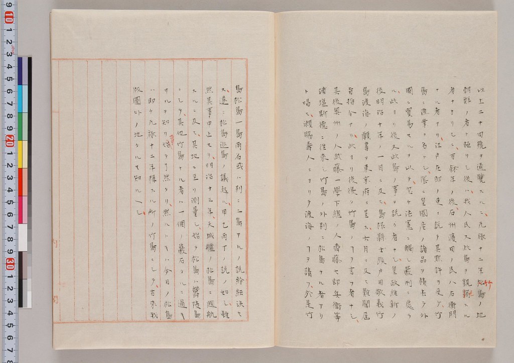

以上二十四號ヲ通覧スルニ元録十二年竹島ノ地朝鮮ノ者ト極リシ後ハ我人民又此覬覦スル者ナカリシニ百余年ノ後石州浜田ノ民八右衛門ナル者アリ 江戸在邸ノ吏ニ説テ其黙許ヲ受ケ竹嶋ニ漁業ヲ名トシ陰ニ皇国産ノ諸品ヲ積去テ外国ニ貿易セルヲ以テ忽チ法憲ニ触レ厳刑ニ処ラル 此ヨリ後又此島ノ事ヲ説ク者無シ 皇政維新ノ後明治十年ノ一月ニ及ヒ島根県士族戸田敬義竹島渡海ノ願書ヲ東京府ニ呈ス 六月ニ及ヒ難聞届旨指令アリ 此ヨリ後復タ竹島ノコトヲ言フ者無シ 其後奥州ノ人武藤一学下総ノ人斉藤七郎兵衛等浦塩斯徳ニ往来シ竹島ノ外別ニ松島ナル者アリト唱ヒ瀬脇寿人ニヨリテ渡海ノ事ヲ請フ 於是竹島松島一島両名或ハ別ニ二島アルノ説粉粉決セス 遂ニ松島巡島ノ議起ル 甲乙丙丁ノ説ノ如シ 雖然其事中止セリ 明治十三年天城艦ノ松島ニ廻航スルニ及ヒ其地ニ至リ測量シ始テ松島ハ欝陵島ニシテ其他竹島ナル者ハ一個ノ岩石タルニ過キサルヲ知リ事始テ了然タリ 然ルトキハ今日ノ松島ハ即チ元録十二年称スル所ノ竹島ニシテ古来我版図外ノ地タルヤ知ルヘシ
---------------------------------------------
After having studied all twenty-four documents thoroughly, it is now clear to me that after Takeshima (Ulleungdo) was determined to be Choson's in 1699, no Japanese had an eye for the island, but about 100 years later, Hachiemon of Hamada, Sekishu (石州浜田) talked the domain official, who was stationed in Edo, into giving him tacit consent (to travel to the island). On the pretext of engaging in fishing, Hachiemon loaded many Imperial products and set sail to trade with foreign countries. Because of his illegal foreign trading, he was severely punished. After this incident, there was no one who talked about this island.
After the Imperial Political Reformation, Toda (戸田敬義), a former samurai family member of the Shimane Domain, submitted a petition to to Tokyo Metropolitan Government in January 1877 to voyage to Takeshima (竹島渡海ノ願書), but in June he received a rejection notice. Since then, no one talked about Takeshima, except for Mutoh Ichigaku (武藤一学) of the Oshu(奥州) Domain and Saito Shichirobee (斉藤七郎兵衛), who claimed that, in addition to Takeshima, there was an island called "Matsushima" (松島) on the route to Vladivostok. (Mutoh) submitted a petition for Sewaki Hisato (瀬脇寿人) to voyage there. As a result, there was so much argument about whether Takeshima and Matsushima were one island with two names or two islands that it was difficult to reach a decision. In the end, opinions on whether to send a survey team to Matsushima was received, as can see in the four opinions (甲, 乙, 丙, and 丁).
There was so much argument about the matter and it was difficult to reach a decision. Although all the talk about conducting a survey had been halted, later in 1880, Warship Amagi (天城) was sent to Matsushima, and I finally came to understand the situation when I learned that "Matsushima" (松島) was Ulleungdo, and the other island, which was called Takeshima (竹島), was just a rock (竹嶼 - Jukdo or Boussole Rock). Thus, today's Matsushima is the island that was called "Takeshima" in 1699 (元禄十二年), and they (Ulleungdo and Jukdo) are not historically Japanese territory."
Since Warship Amagi only sailed to Ulleungdo and surveyed the area there and did not go to today's Takeshima (Liancourt Rocks), it is apparent that Takeshima, which was described as not being much bigger than a rock," was definitely not referring to today's "Takeshima" (Liancourt Rocks/Dokdo), but rather was referring to Ulleungdo's neighboring island of Jukdo. After this discovery, Japan's MOFA and the navy started referring to Ulleungdo as "Matsushima," and today's Takeshima as "Liancourt Rocks."

Takeshima Kosho (竹島考証)

"Takeshima Kosho" is a 3-volume set of books that detailed the debates in the the MOFA. The first volume (上) contains the study of many historical records and documents from Choson, China, and Japan. The second volume (中) focuses on the "Takeshima Incident" (竹島一件), which happened between 1692-1699 and involved Ahn Yong-bok's trips to Japan. The last volume (下) starts with the Aizuya Hachiemon case, "Takeshima Incident in Tenpo (天保の竹島一件)," and continues with the numerous petitions (submitted by Japanese civilians and officials between 1876-78 ) calling for development of Matsushima. Then it describes the debates between officials inside the MOFA, the survey by the Amagi, and finally the conclusion of the investigation. Here is a brief explanation for the last volume, which is the most important of all.

Contents of the third volume(下)

No.1-3 : The incident of Aizuya Hachiemon Case

No.4-7 : "A petition to develop Takeshima(Ulleungdo)(竹島渡海之議)" by Toda Takayoshi(戸田敬義), a former samurai class of Shimane, to the governor of Tokyo in Jan. 1877

No.8 : "A petition to develop Matsushima(Ulleungdo) (松島開拓之議)" by Muto Heigaku (武藤平学) to MOFA in July 1876

No.9-10 : "A petition by Kodama Sadaaki (児玉貞陽建白)" Kodama submitted petition to develop Matsushima(Ulleungdo) to MOFA in July 1876.

No.11 : "Concerning Matsushima I (松島之議一)" Watanabe Kouki (渡辺洪基) claims if Matsushima in concern is Hornet Rocks(Liancourt Rocks), it is Japanese territory.

No.12 : "Concerning Matsushima II (松島之議二)" Watanabe Kouki (渡辺洪基) claims Matsushima(Liancourt Rocks) in old Japanese documents is Japanese territory.

No.13 : "An application and petition to develop Matsushima (Ulleungdo)(松島開拓願書並建言)" Saito Shichirobee(斉藤七郎兵衛) to Sewaki Hisato (瀬脇寿人) in Dec. 1876

(Attached Note by Tanabe : "Matsushima is Choson's Ulleungdo")

No.14 : "Official Correspondence No.1 , 1877 (明治十年 平信第一)" by Sewaki Hisato (瀬脇寿人) to Terajima Munenori (寺島宗則) in April 1877

No.15 : "Official Correspondence No.2, appendix A, 1877 (明治十年 平信第二 番外 甲号)" by Sewaki Hisato (瀬脇寿人) to Terajima Munenori (寺島宗則) in May 1877

No.16 : "A petition to open Matsushima(Ulleungdo)(松島開島之建白)"by Muto(武藤平学) in May 1877

No.17 : "Official Correspondence No.3 in June 1877 (公信第三号 明治十年六月 )" by Sewaki to Terajima

(Attached Note by Tanabe : "Matsushima is Choson's Ulleungdo")

No.18 : "Correspondence No.8 1877(明治十年第八号)" by Sewaki to Terajima in July 1877

No.19 : "Different Opinion on Matsushima(松島異見)" by Sakata Morotoo(坂田諸遠), a MOFA official one of the author of "Compilation of Japanese Diplomatic Documents in Edo Era (続通信全覧)", claims Takeshima(Ulleungdo) and Matsushima(Hornet Rocks/Liancourt Rocks) are under Japanese Oki's jurisdiction in Aug. 1877.

No.20 : "A petition for Development of Matsushima(Ulleungdo) (松島開拓願)" by Shimomura Linhachiro(下村輪八郎) and Saito Shichirobee (斉藤七郎平衛) to Sewaki in Aug. 1878

No.21 : "Arguments on the Pros and Cons of Inspecting Matsushima(松島巡視要否ノ議)" Tanabe Taichi(田邉太一) states opinion A, B and C (甲乙丙)

No.22 : "Middle Opinion by Watanabe(渡邉洪基)"

No.23 :
"Opinion D(議論丁)" Tanabe claimed that Matsushima is Japanese name and it is actually Usan, a neighbouring island of Ulleungdo. He claims that though the belonging of Matsushima(Usan) is not clear,
sending warship to survey may cause conflict between Choson. (Usan in concern is Ahn's so-called Japanese Matsushima (Jukdo), not today's Takeshima/Liancourt Rocks, apparently.)

No.24 : "Waterway Report No. 33 (水路報告第三十三號)" by Yanagi Narayoshi(柳楢悦)

Conclusion by Kitazawa :
Matsushima was Ulleungdo and the island then called Takeshima was today's Jukdo, about two kilometers away from Ulleungdo, are not Japanese territory.


Referenced documents in the book (竹島考證引用書) :
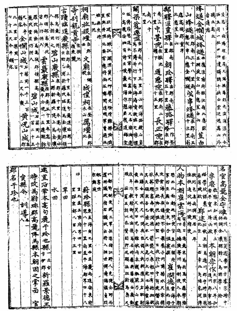
Choson Documents(朝鮮書) : 東國通鑑, 東國輿地勝覽, 高麗史, 通文館志
Chinese Documents(支那書) : 武備志, 登壇必究, 圖書篇, 八篇類纂, 朝鮮賦

Japanese Documents(國書) : 大日本史, 竹島雜志, 竹島圖説, 朝鮮通交大記, 善隣通書, 竹島紀事, 竹島考, 磯竹島覺書, 因府年表, 通航一覽,

Japanese Correspondent Documents(公信類) : 竹島書類雜纂, 松島之議, 松島關係書類, 浦潮斯德來信, 浦潮港日記

26.5.08

1875 - "Chosen Yochi Zenzu" by Sekiguchi Bisyo (關口備正)

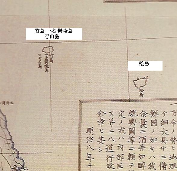
Below is an 1875 Japanese map of Korea, made my Sekiguchi Bisyo (關口備正). The map is important in the Dokdo-Takeshima debate because it clearly shows Usando (亐山島) as a neighboring island of "Takeshima" (竹島), which was also labeled as "Ulleungdo" (鬱陵島), while also showing Matsushima (松島) as an island much farter to the southeast. This is important because it is clear evidence that Japanese believed Usando to be a neighboring island of Takeshima (Ulleungdo) rather than the Japanese island of Matsushima.


The above map is also a perfect example of how Japanese and Western maps often mismapped Takeshima and Matsushima in the 1800s . Though the Japanese believed Takeshima and its neighboring island of Usando to be Korean territory and Matsushima to be Japanese territory, the islands were often mismapped in the 1800s, due largely to a mapping error by the British ship "Argonaut" in 1789. The British ship mapped Ulleungdo (Argonaut) as being much farther northwest of its actual location and named it "Argonaut."

The shape and location of the island labeled as "Matsushima" (松島) on the above map tell us that it was actually Ulleungdo (鬱陵島), even though the island much farter to the northwest, was labeled as "Takeshima, also called Ulleungdo" (竹島 一名 鬱陵島). However, the island labeled as Takeshima (Ulleungdo) on the above map was actually the non-existent island of Argonaut.

Also, notice that the small island drawn just off the southwest shore of the island labeled as Takeshima was labed as "Ulsando" (亐山島), which was one of the misspellings of "Usando" (于山島). As I said above, this is evidence that the Japanese believed Usando to be a neighboring island of Ulleungdo rather than "Matsushima" (松島 - Liancourt Rocks), which the Japanese believed to be their island.

A Japanese survey of Ulleungdo in 1880 confirmed the mapping error.


22.5.08

Korean Teacher Union Calls on Japan to Apologize for Dokdo

A May 20 Yonhap News article entitled, "Korean teachers demand apology from Japan over Dokdo claim," says that a South Korean teachers's union "has called for an apology from Japan over its new educational campaign to claim Dokdo."

In a letter addressed to Japanese Education Minister Kisaburo Tokai, the "Korean Federation of Teachers' Associations" said the following:
"The move by the Japanese government to asert its territorial claim to Dokdo in the curriculum handbook for teachers is an act of usurpation of the sovereignty and the territory of the Republic of Korea."
I think Korea's teachers' union should apologize to the world for making such a ridiculous demand. Also, I think Korean President Lee Myeong-bak should apologize for making "Dokdo" an issue after having said just a little over a month ago that he would put aside historical differences with Japan to improve ties.

Korean presidents seem to have a hard time remembering the promises they make, but President Lee seems to be having an especially hard time remembering what he said to Japan about historical isssues and what he said to the United States about US beef imports.

21.5.08

1880 - Japanese Warship "Amagi" (軍艦天城) Surveys Ulleungdo and finds "Takeshima" is Jukdo.

In 1876, Mutoh Heigaku (武藤平学), a Japanese businesssman in Vladivostok, proposed to the Japanese Ministry of Foreign Affairs that the government allow him to develop the Japanese territory of Matsushima. See HERE"

Following this, many Japanese who believed there to be a Japanese island called "Matsushima" (松島) in the sea of Japan started sending numerous petitions to Minstry of Foreign Affairs between 1876 and 1878 asking that they be allowed to develop the island. Though Japanese in the Edo era had been clearly aware of the locations of Takeshima (竹島 = today's Ulleungdo) and Matsushima (松島 = today's Takeshima/Liancourt Rocks/Dokdo), the non-existent island on Western maps called "Argonaut" and the turmoil in the Japanese government following the fall of the Edo Shogunate caused confusion and debate on the names and locations of islands in the Sea of Japan between Japan and Korea. See HERE.

In order to resolve these questions, Foreign Minister Terajima Munenori (寺島宗則) finally ordered an on-site survey of Ulleungdo in 1880 (明治十三年) and dispatched the warship Amagi to the Ulleungdo area to clear up the name confusion concerning the islands in the region. The Amagi discovered that "Matsushima" (松島) was actually Ulleungdo and "Takeshima" (竹島) was a small island off the northern shore of Ulleungdo, which Koreans pronounce as Jukdo (竹嶼). The map made during the survey confirms that Takeshima was Ulleungdo's neighboring island of Jukdo (竹島).

Kitazawa Masanari (北澤正誠) wrote an account of this survey in the Takeshima Kosho (竹島考証 - "A Study of Takeshima"). In his account, he concluded that Matsushima was Ulleungdo and confirmed that both Ulleungdo and the island he called Takeshima, which was Ulleungdo's neighboring island of Jukdo, were not Japanese territory. Jukdo is about about two kilometers off Ulleungdo's east shore.

Here is what Kitazawa wrote about the 1880 Amagi survey.

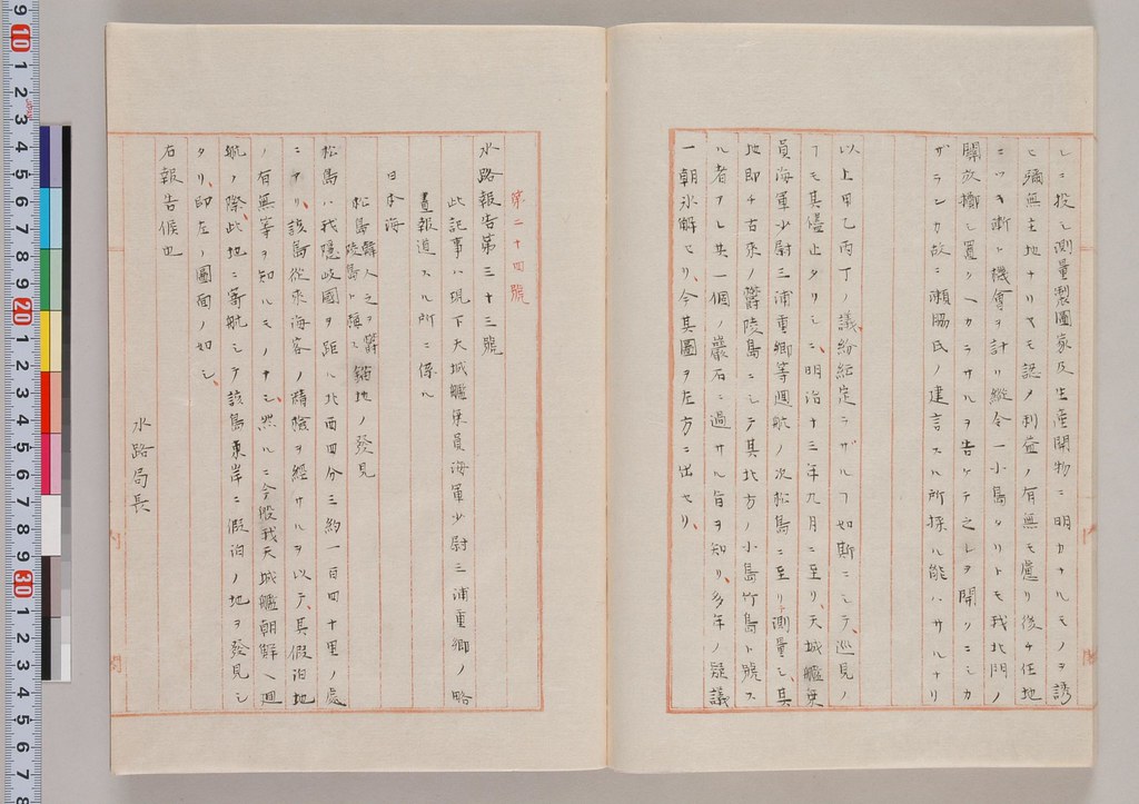
以上、甲乙丙丁ノ議紛紜定ラサルコト如斯ニシテ、巡見ノコトモ其儘止タリシニ、明治十三年九月ニ至リ天城艦乘員海軍少尉三浦重鄕等廻航ノ次松島ニ至リ測量シ、其地即チ古來ノ鬱陵島ニシテ其北方ノ小島竹島ト號スル者アレ共、一個ノ巖石ニ過サル旨ヲ知リ、多年ノ疑議一朝永解セリ、今其圖ヲ左方ニ出セリ、

---------------------

In the above (items) 甲, 乙, 丙, and 丁, there was so much argument about this and that that it was difficult to reach a decision. Even all the talk about conducting a survey had ended. In September 1880, when navy Ensign 三浦重郷 and others of the Warship Amagi returned to port, they said they reached "Matsushima (松島)", where they conducted a survey. The island was the so-called "Ulleungdo(鬱陵島)" of old, where they found a small island off the northern shore that someone said was called "Takeshima(竹島)", though it was not much bigger than a rock. In one morning, long-held suspicions and arguments were cleared up. Now, I present the following picture.

The following is the report and the map of Ulleungdo and Jukdo made during the Amagi survey. It was attached to Kitazawa's "Takeshima Kosho" and labelled as "No.24", which was the last number of the referenced documents in the book.

第二十四號

水路報告第三十三號

此記事ハ現下天城艦乘員海軍少尉三浦重鄕ノ略書報道スル所ニ係ル、

日本海

松島(韓人之ヲ蔚陵島ト稱ス)錨地ノ發見

松島ハ我隱岐國ヲ距ル北西四分三約一百四十里ノ處ニアリ、該島從來海客ノ精撿ヲ經サルヲ以テ其假泊地ノ有無等ヲ知ルモノナシ、然ルニ今般我天城艦朝鮮ヘ廻航ノ際此地ニ寄航シテ該島東岸ニ假泊ノ地ヲ發見シタリ即左ノ圖面ノ如シ、右報告候也、

明治十三年九月十三日 水路局長海軍少將 柳楢悦

----------------------------

No. 24

Waterway Report No. 33

This report was submitted by navy Ensign Miura Shigesato (三浦重郷), who is a crewman of the Amagi.

Sea of Japan

At Matsushima, which Koreans call Ulleungdo, we found anchorage. Matsushima (Ulleungdo) is located about 140 ri northwest 3/4 of Oki Prefecture. It was unknown whether or not anchorage was available because no ship had done a precise survey of the area. However, our ship, Amagi, called at this place during our trip to Joseon (Korea) and found a place to anchor off the east shore of the island, as is shown on the map.

September 13, 1880
Navy Rear Admiral Yanagi Narayoshi
Director of the Bureau of Hydrography

After the above report, Kitazawa, the author of this compilation and MOFA official, wrote the final conclusion as follows:

"I finally came to understand the situation when I learned that "Matsushima" (松島) was Ulleungdo, and the other island, which was called Takeshima (竹島), was just a rock(一個の岩石)(竹嶼/Jukdo=Boussole rock). Thus, today's Matsushima is the island that was called "Takeshima" in 1699 (元禄十二年), and (they [= Ulleungdo and Jukdo] are) not historically Japanese territory."

「松島は鬱陵島にして、その他竹島なる者は一個の岩石たるに過ぎざるを知り、事始て了然たり。然るときは今日の松島、即ち元禄12年称する所の竹島にして、古来我版図外の地たるや知るべし」.

Reference : Lies, Half-truths, & Dokdo Video, Part 5

20.5.08

Are Google & Korea conspiring to hide "Jukdo" (竹島)?

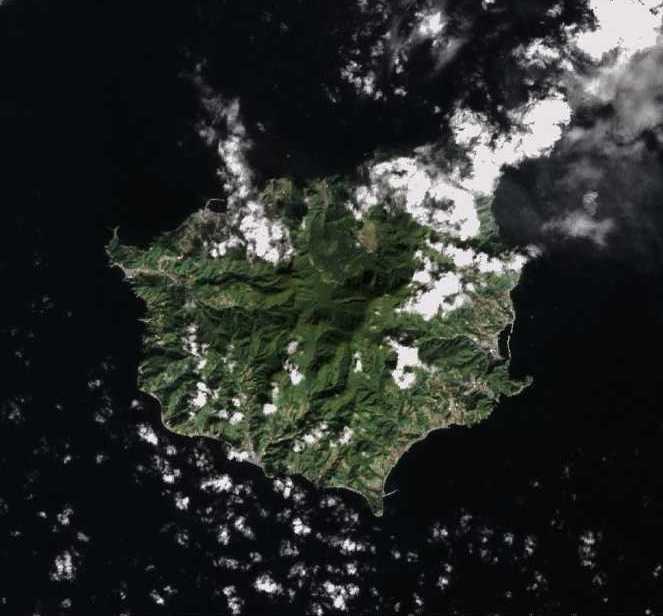
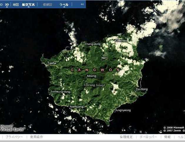
One of our frequent commenters here on this blog, GTOMR, has made a very interesting observation about a map of the Korean island of Ulleungdo (鬱陵島) on the internet map service "Google Earth." He compared the map of Ulleungdo on Google's "Google Earth" map service with the map of Ulleungdo on Microsoft's "Virtual Earth" map service and noticed that both maps appear to be the same, except that the Virtual Earth map shows Ulleungdo's neighboring island of Jukdo (竹島) while the Google Earth map does not.

See the maps belows:

Landsat Photo taken on April 8, 2000


Notice in the above photo that Ulleungdo's neighboring island of Jukdo can be clearly seen off Ulleungdo's east shore. Now compare it with the following Landsat photo of Ulleungdo taken on September 29, 1999.

Landsat - September 29, 1999


Even though it is slight obscured by clould cover in the above photo, Jukdo is still visible off Ulleungdo's east shore. Now compare the above photo with the following photo from Microsoft's Virtual Earth.

Microsoft Virtual Earth


Notice that the cloud pattern in the the Virtual Earth photo above is the same as that in the September 29, 1999 Landsat photo, which tells us that they are the same photos. Notice also that Jukdo can be seen in both photos. Now compare the above photos with the following photo from Google Earth.

Google Earth


Even though the cloud pattern in the Google Earth photo appears to be the same as that in the Virtual Earth and the September 29 Landsat photos above, Ulleungdo's neighboring island of Jukdo and the clouds near it are faded out in the Google Earth photo. Why? Could it be that Google does not what people to know that Ulleungdo has a neighboring island? See also HERE.

Now look at a satellite photo of Ulleungdo taken from Korea's Arirang 1 satellite.

Notice in the above photo that Ulleungdo's neighboring island of Jukdo does not appear because it has been chopped off. I do not know who did the chopping, but I wonder why they did it.
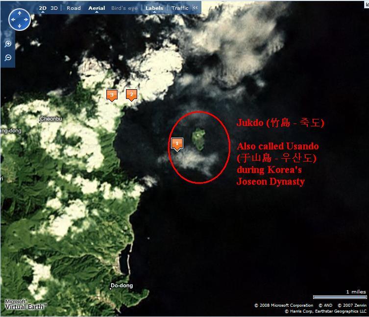
Below is a closeup shot of Ulleungdo's neighboring island of Jukdo from Microsoft's Virtual Earth satellite photos. The writing in red was added by me:


Old Korean and Japanese maps show that Ulleungdo's neighboring island of Jukdo was once called "Usando" (于山島 - 우산도). Even though Koreans claim that the Usando on the old maps was Liancourt Rocks (Dokdo/Takeshima), the fact that it was drawn just offshore Ulleungdo and the fact that it was drawn as one island, not two, tell us that it could not have been Liancourt Rocks. Liancourt Rocks is ninety-two kilometers southeast of Ulleungdo and is essentially made up of two rock islets, not one.

A suspicious person might jump to the conclusion that Ulleungdo's neighboring island of Jukdo was excluded from Google Earth's photo and Korea's Arirang satellite photo because it was feared that people might see the photos and realize that the Usando on old Korean and Japanese maps was actually Ulleungdo's Jukdo. Of course, that would be an unproven suspicion.

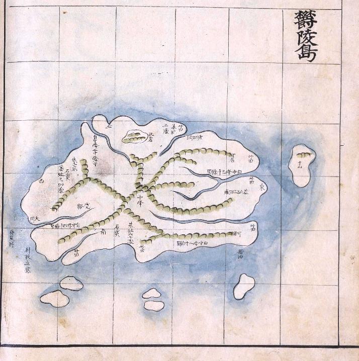
By the way, the following is an old Korean map of Ulleungdo made sometime between 1777 and 1787. Notice that it shows a small island just off Ulleungdo's east shore labeled as 于山, which is pronounced as "Usan" (우산). The map is stored in the National Library of Korea.

Korean news site displays childish nationalism.

In a May 20 article HERE, on the Korean news site "Joins," a Korean mapping expert said that the Japanese government's recent map of "Dokdo" (Liancourt Rocks) is more accurate and better made than the map of the island made by the Korean government last year. For example, he said that Korea's map showed "Dokdo" with only twelve neighboring islets and rocks while the Japanese map showed it with fifty.

However, what I found interesting about the article was that the Korean news site could not even show the Japanese map without blotting out the Japanese name for the island. I think that is an example of just how immature and insecure Koreans are when it comes to "Dokdo."

Below is the photo from the news article. Korea's map is on the left, and Japan's map is on the right. You can see where they blotted out the names on the Japanese map:


Below is the original photo of the Japanese map.

19.5.08

A Russian businessman published a book for appealing restoration of four islands of Kuril to Japan.

This is an interesting article from 16 May of The Hokkaido Shimbun Press(北海道新聞) (cache). It's really good to see Russian still holds the freedom of speech. True friendship comes only from truth, not distorted facts.

Mr. Chetulin, a Russian businessman who lives in Vladivostok, published a book on the appeal to Russia a restoration of four island of Kuril to Japan in hope of true friendship.

Mr. Alexandre Chetulin(56), a Russian businessman who deals the import sales such as used cars of Japan in Vladivostok, published the book at one's own expense on the appeal for admitting northern territories as Japanese territory, and urging to build true friendly relationship. It's unusual for Russian to publish the book which appeals for four island restoration around the Russian Far East.

Mr. Chetulin had doubt in perception of history when the Soviet Union broke-up in 1991. He spent seven years from 2000, piled up documents and interviewed the specialists to learn four islands were Japanese territories. He started writing because "I want to tell a correct history to the Russian people who has opposite recognition against truth".

Mr. Chetulin says "Though it's government's responsibility to solve the territorial issue, it is important that the people understand the issue. World War II doesn't end if this problem is not solved." He has been appealing in the Khabarovsk junior high schools and in front of the Ministry of Foreign Affairs.

The book entitles, "To whom do Kuril Islands belong ?", and prints 10,000 on the A5 size and the strangeness type page 52.Since he wants the Russian people to read widely, the history and grounds, etc. were concisely brought together. Many words of "Thank you for teaching the truth" were sent to him, while there were no one who complains in local Vladivostok.

Mr. Chetulin claims, "Because it is originally one of Japan's, still, it is necessary to restore it", even though the surrounding of northern four islands is a treasure house of living aquatic resources including the crab. He continues that he's going to continue this activity for understanding, since "the conclusion of the territory issue becomes a new start of Japanese-Russian relations".

Korea Times: "Teacher's Guidebook Alleges Japan to Claim Dokdo"

Here is a link to a Korean news article on Japan's decision to include her claims on Liancourt Rocks (Takeshima/Dokdo) in their teacher guidebooks.

Link to Korea Times Article

Here are the quotes from the article:
  • "The guidelines may exert considerable influence on textbook manufacturers, and highlighting the unilateral views of one side as if it represents the truth should not be condoned,'' said Cho Yoon-seon, the spokeswoman for the ruling Grand National Party.
    .
  • "If such actions continue Japan must be held accountable for all negative developments in bilateral relations,'' said UDP spokeswoman Cha Young.
    .
  • "By proclaiming that Seoul will not take issue on the textbook and Dokdo issue, the incumbent administration brought about the current situation,'' a DLP party spokesperson said.
I find the above comments pretty ridiculous. Did Koreans really expect Japan to give up her claim to Liancourt Rock simply because Korea's president visited Japan? Has Korea given up her claim on Dokdo and removed all references to it from Korean textbooks for the benefit of Korea-Japan relations? If not, how can Koreans expect the Japanese to give up their claim?

If Koreans really want to build a good relationship with Japan, then they have to learn to accept the reality that both Korea and Japan claim Liancourt Rocks, instead of getting angry every time Japan mentions "Takeshima."

18.5.08

Korean Fishing Boat Seized by Japanese Patrol Boat

The following is my translation of a May 18 report on Korea's MBC News:

"Korean Fishing Boat Operating Near Dokdo Seized by Japan"

At about 8:30 this morning, the Deokyang-ho, an 89-ton, gill-net fishing boat operating out of Port Guryong in Pohang City, was siezed by a Japanese Maritime Authority fishery inspection ship while operating in waters 115 kilometers southeast of Dokdo and was tolled to Port Sakai in Tottori Prefecture.

The Japanese Maritime Authority is investigating whether the Deokyang-ho--with its 9-men crew, including the captain--had crossed over about one kilometer into Japan's exclusive economic zone (EEZ). Pohang maritime police are trying to determine the exact circumstances of the seizure.

Link to the Korean News Report

1880 - R. Hausermann's Map of Korea

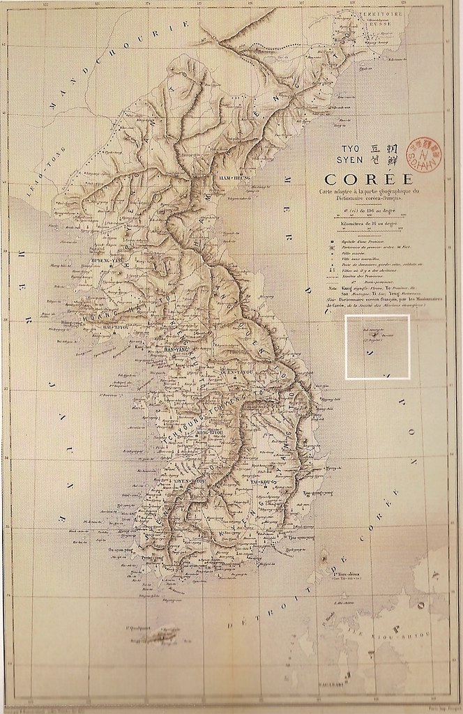
Below is a map of Korea called "Corée" (Tyo Syen), which was produced by the French organization Mission Etrangères de Paris (MEP) in 1880. Supposedly, the map was based on Father Kim Degeon's Carte de la Corée of 1846. The map is said to be stored in the Research Foundation of Korean Church History.

Notice below the full map that there is a cutout of Ulleungdo (Oul-neung-to) that shows Ulleungdo's neighboring island of Jukdo (竹島) labelled as "Ou-san," which was the French pronunciation for Usan (于山). This map is more evidence that Usando (于山島) was Ulleungdo's neighboring island of Jukdo (竹島), not Liancourt Rocks (Dokdo/Takeshima).


Japanese Documentary on Dokdo-Takeshima Dispute

The following is a Japanese documentary on the Dokdo-Takeshima dispute. The documentary is already a couple of years old, but it seems to be quite informative and balanced, though I do not know for sure since I do not understand Japanese.

I am posting the videos again for Japanese visitors to the blog who may be new to the issue, but also because I am would like to know more about the people in the videos and what they are saying. For example, is the man speaking at the beginning of the second video Japanese or Korean? Also, who are the other people in the video?

Anyway, if you have any thoughts on the videos, feel free to express them.

Part 1


Part 2


Part 3


Part 4

Japanese Ministry of Education : "Takeshima Japanese soil, Teachers handbook to say isles claimed by Tokyo, Seoul belong to Japan"

The following news article comes from today's Yomiuri Online. I learned of the news from Naver's "Enjoy Korea" Web site, which is a Korean site. The news has not been reported on Japanese TV. I do not understand why most Japanese media ignore this kind of news, but it seems the Koreans never fail to report it for the Japanese.

The Education, Science and Technology Ministry will incorporate a description
of the Takeshima islets in the Sea of Japan, over which Japan and South Korea
claim sovereignty, as "Japanese territory" in its handbook on the revised
curriculum guideline for social studies classes at middle schools, The Yomiuri
Shimbun learned Saturday. (May. 18, 2008 The Yomiuri Shimbun)

Read the rest of the artice here cache

I am glad to hear that our government has finally started doing its job.

17.5.08

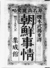
1882 - "The Joseon Situation" (朝鮮事情), by Enomoto Takeaki(榎本武揚) excludes Takeshima/Dokdo from Joseon territory

"The Joseon Situation" (朝鮮事情) is a partial translation of Charles Dallet's "Histoire de L'Eglise de Corée"(1874). Enomoto Takeaki (榎本 武揚), who was the first Japanese ambassador to Russian capital of Saint Petersburg, had the original book sent from Paris to Saint-Petersburg in December 1875 in order to collect information on Joseon. He translated it into Japanese with a help of his science mentor, Dutch Doctor Pompe van Meerdervoot, Johannes Lydius Catherinus (1829-1908). He finished the translation and sent it to Japan by January 15, 1876. It is believed the first edition was published in 1876-77.

This book is said to have had a great influence on the Meiji government's political plannning in regard to Joseon. Since it was a translation of "Histoire de L'Eglise de Corée," it naturally excluded Takeshima/Dokdo from Joseon territory.

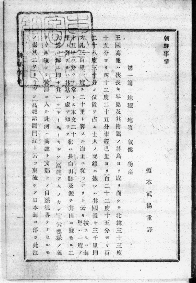
The following is an excerpt from the book:

王国高麗ハ狭長キ半島及其附属ノ郡島ヨリ成リ而シテ北緯三十三度十五分ヨリ四十二度二十五分東経(巴里ヨリ)百二十二度十五分ヨリ百二十八度三十分ノ位置ヲ占ム

The kingdom of Korea (Corea) consists of an oblong peninsula and it's neighbouring islands. It is located between 33° 15' N. to 42° 25' N. ( from Paris) and 122° 15’ E. to 128° 30’ E [ + 2°20’, which is the eastern longitude of Paris, would be 130° 50’ E (Greenwich Meridian)]

Enomoto Takeaki (榎本 武揚, 1836-1908)

Viscount Enomoto Takeaki was a Japanese Navy admiral faithful to the Tokugawa Shogunate. He started his navy career by entering the newly formed Naval Training School in Nagasaki. He was then sent for five years to the Netherlands to study Western naval techniques. He fought against the new Meiji government(明治政府) until the end of the Boshin War (戊辰戦争), but after 3 years of imprisonment, he was forgiven for his crime of high treason in 1872. The Meiji government needed Enomoto, who was educated in Europe and had knowledge of international laws.

In 1874, Enomoto was given the rank of vice-admiral in the newly established Imperial Japanese Navy and the first Japanese ambassador to Russia. The following year, he was sent as a special envoy, or Minister Plenipotentiary, to Russia to negotiate the Treaty of Saint Petersburg (1875). He successively held several ministry positions in the government, and was especially active in promoting Japanese expansionism through settler colonies in the Pacific Ocean and South- and Central America.

2008 marks the first centennial of Enomoto Takeaki's death.

16.5.08

1967 American map showed "Takeshima" as Japanese

Below are scans of a 1967 map of Japan and Korea, which was a map made by the American mapmaking company, Hammond. The map shows Liancourt Rocks (Dokdo/Takeshima) labeled as "Takeshima" and marks them as being Japanese territory. The story about the map was reported HERE, in the May 5th edition of the Japanese newspaper, "The San-in Chuo Shimpo."

According to the article, a Mr. Sugihara, who is a consultant on the "Takeshima issue" for Shimane Prefecture, explained, "In the US, Takeshima was recognized as Japanese territory around that period." Actually, the US government had told Korea in the 1950s that she considered Liancourt Rocks to be Japanese territory (see HERE), so the 1967 American map may have been a continued reflection of that belief.

Korea calls Liancourt Rocks "Dokdo" (獨島 - 독도) and has been forcibly occupying them since the 1950s, when Korean President Rhee Syngman unilaterally declared them Korean territory.

14.5.08

1662: "Gi-eon - Cheongsa Yeoljeon" (記言 - 淸士列傳): "He traveled to Weolsong and viewed Ulleung/Usan." (遊越松望鬱陵于山)

Heo Mok (許穆 - 허목) was a famous Korean scholar and government official who lived from 1595 to 1682. (See the picture to the left.) His pen name was Misu (眉叟), but he was also called "the old man of Tae-ryeong" (台嶺老人). Among the government offices he held was the Dohobusa (都護府使) of the Samcheok (三陟) region. Also, at the age of eighty-one, he was appointed as the U-euijeong (右議政), which was one of the highest positions in the Joseon government.
Heo Mok was also well traveled and a fairly prolific writer. Among his works were the Cheokjuji (陟州誌) and Gi-eon (記言). The Gi-eon was a 67-volume set of writings on his studies of famous scholars and philosophers. One of the scholars written about in the Gi-eon was Kim Si-seup (金時習), who was a famous Korean scholar and government official who lived from 1435 to 1493.
According to the Gi-eon, Kim Si-seup could read by the time he was eight months old and could read and understand the Taehak (大學) and the Junyong (中庸) by the time he was five, which earned him the nickname "Ose-dongja" (五歲童子 - "the 5-year-old child"). He was so famous, in fact, that he got the attention of King Sejong (世宗), who sent a messenger with royal gifts and the message, "Raise him well because he will be of great service someday" (善養之 當大用也). By the time of King Munjong (文宗 : 1450 - 1452), Si-seup had already grown into a well-respected scholar with vast knowledge and extraordinary talent, but with the abdication of King Danjong (端宗) in 1455, Si-seup was forced to flee and begin a life as a wanderer. He took advantage of the situation, however, to visit many temples and famous places around the country. Among the famous places he visited was Weolsong Pavilion (越松亭), on the east coast of Korea, from which he viewed Ulleung/Usan. Here is the relevant passage:
登臨楓嶽五臺 窮海堧
He climbed (登臨) Mount Pung-ak (楓嶽) and Mount Odae (五臺), and the vast sea (窮海) was empty (堧).


遊越松望鬱陵于山
He traveled (遊) to Weolsong (越松) and viewed (望) Ulleung/Usan (鬱陵于山).
The above sentence is quite important in the Dokdo-Takeshima debate because, as you can see from the above quote, both Ulleungdo (鬱陵島) and Usando (于山島) were described as being visible from Weolsong (越松), which is on the east coast of Korea near Uljin. This quote is important because it is more evidence that the Usando in old Korean documents was not referring to Liancourt Rocks (Dokdo/Takeshima), which is much too far away to be viewed from the east coast of Korea. It is also evidence that the phrase "Ulleung/Usan" (鬱陵于山) was used to refer to the two islands as an "island group." In other words, the passage did not mean that both islands of Ulleungdo and Usando were seen from Weolsong, but that the Ulleung-Usan island group was seen.

The Ulleung-Usan island group is also what was being referred to in the following passage from King Sejong's 1454 geography text, which was describing the county of Uljin (蔚珍) and its surrounding area:
于山武陵二島在縣正東海中 二島相去不遠 風日淸明 則可望見
The two islands of Usan and Muleung (于山武陵二島) are in the sea due east of this village (在縣正東海中). The distance to the two islands is close enough (二島相去不遠) that they are visible on clear days when the wind is blowing (風日淸明 則可望見).
Korean historians try to claim that the distance mentioned in the above passage was referring to the distance between the two islands, not to the distance between Uljin and the two-island group, but since the passage was among others giving distances and bearings from Uljin to places in the surrounding area, we know that the distance referred to was the distance from Uljin to the Ulleungdo-Usando island group. In the case of Ulleungdo and Usando, the bearing was given as "in the sea due east of Uljin," and the distance was given as "the distance to the two islands is close enough that they are visible on clear days when the wind in blowing" (二島相去不遠 風日淸明 則可望見).

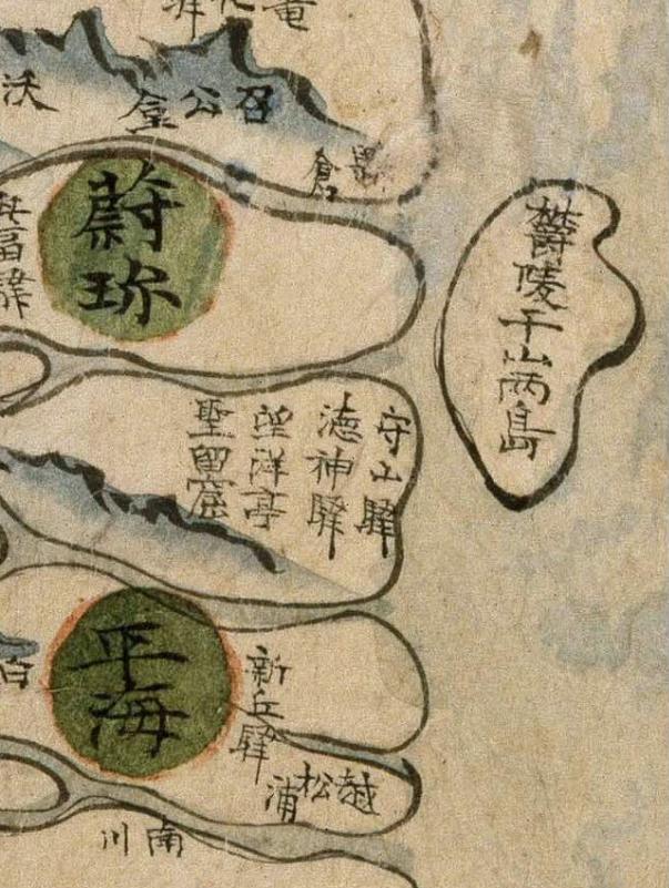
Korean maps even showed the two islands as an island group. For example, the following Korean map of Gangwon Province from the mid-1700s showed Ulleung/Usan (鬱陵于山) as one island off the east coast of Uljin (蔚珍), but it was labeled as 鬱陵于山兩島, which means "the two islands of Ulleung and Usan."


As you can see from the above, the "Ulleung/Usan" reference in Heo Mok's story about Kim Si-seup was consistent with other Korean documents and maps, which means that the Usando (于山島) mentioned in old Korean documents and maps was not a reference to Liancourt Rocks (Dokdo/Takeshima), but rather was just a reference to a neighboring island of Ulleungdo. The neighboring island was almost certainly Ulleungdo's neighboring island of Jukdo (竹島), which is about 2.2 kilometers off Ulleungdo's east shore. By the way, in the above map, you can see Port Weolsong (越松浦) just to the lower right of Pyeonghae (平海), which is the lower green circle. Weolsong (越松) was mentioned in Heo Mok's story as the place from which Kim Si-seup saw Ulleung/Usan (鬱陵于山) .

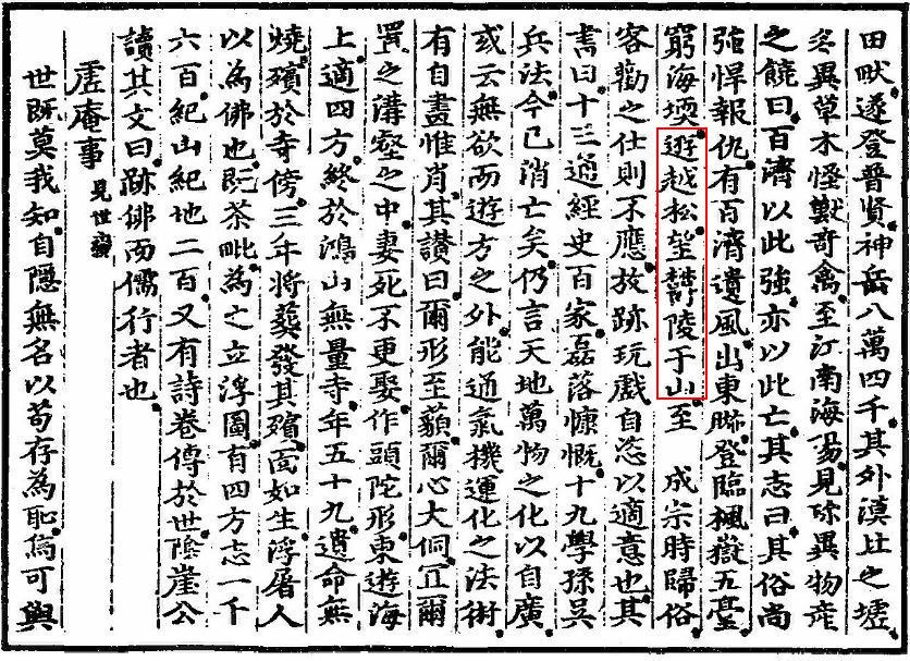
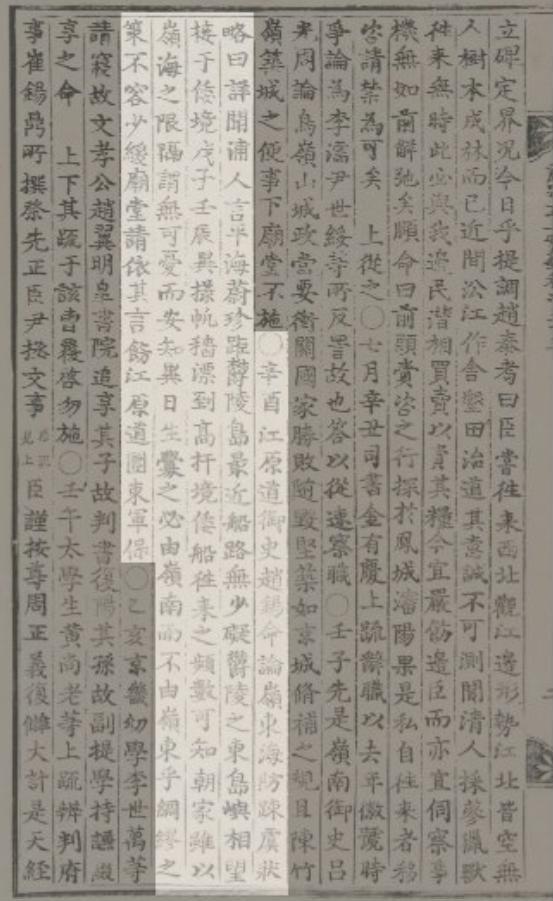
Below is a copy Heo Mok's story of Kim Si-seup, under the title of "Cheongsa Yeoljeon" (淸士列傳), from the 11th volume of the Gi-eon (記言). The passage that mentions Ulleungdo and Usando is outlined in red. (Click on the images to enlarge.)


記言卷之十一 中篇
淸士列傳
金時習者。本滄海人。生八月。能知書。五歲。通大學,中庸。長者師之。集賢學士崔致雲見之曰。奇才。乃命名時習。字悅卿。世宗聞之。欲召見之不可。令承政院召見之。厚賜其家曰。善養之。當大用也。於是四方號之曰。五歲童子。而不名也。至文宗時。時習稍長成。旣博達異能。名譽益多。及魯陵遜位。時習悉燒其書。因亡去。逃於浮屠。以絶跡於世也。楊州水落,壽春史呑,海上雪岳,寒溪,月城金鰲。皆時習樂居其間者也。自號贅世翁。或曰淸寒子。或曰東峯。時習早得大名。逢世故。一朝逃世絶俗。佯狂自隱。乖詭譎奇。以取怪而不悔也。以爲居治世。潔身亂倫。恥也。遇亂世。離群遠引。善也。慨然長往。行名山澤。遊摩阿岬。開京觀古國學。薩水問七翁仲。平壤觀井田畎。遂登普賢神岳八萬四千。其外漠北之墟多異草木怪獸奇禽。至江南海陽。見珍異物產之饒曰。百濟以此強。亦以此亡。其志曰。其俗尙強悍報仇。有百濟遺風。出東暆。登臨楓嶽,五臺。窮海堧。遊越松。望鬱陵,于山。至成宗時歸俗。客勸之仕。則不應放跡。玩戲自恣。以適意也。其書曰。十三。通經史百家。磊落慷慨。十九。學孫吳兵法。今已消亡矣。仍言天地萬物之化以自廣。或云無欲而遊方之外。能通氣機運化之法術。有自畫惟肖。其讚曰。爾形至藐。爾心大侗。宜爾置之溝壑之中。妻死不更娶。作頭陀形。東遊海上。適四方。終於鴻山無量寺。年五十九。遺命無燒。殯於寺傍。三年將葬。發其殯。面如生。浮屠人以爲佛也。旣茶毗。爲之立浮圖。有四方志一千六百。紀山紀地二百。又有詩卷。傳於世。陰崖公讀其文曰。跡佛而儒行者也。

1876 - "Keirinjiryaku(鶏林事略)" by Sewaki Hisato (瀬脇寿人)excludes Takeshima/Dokdo from Choson

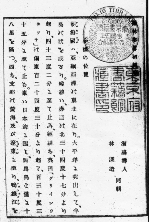
Sewaki Hisato was official of the Japanese Ministry of Foreign Affairs (MOFA) and a Dutch scholar. Later, he also became one of the first English scholars in Japan. He was stationed as the first trade secretary (practically a consul) at the Japanese trade office in Vladivostok in 1876. While there, he wrote a book entitled, "A Short Treatise on Korea" (鶏林事略), which was published in 1876 (明治九年).

In the book, he said that the eastern limit of Korea's border was at 130°35’E. That suggests that Sewaki believed Liancourt Rocks (Takeshima/Dokdo) to be outside Korean territory.

The following is an excerpt from the book:

朝鮮国は、亜細亜洲の東北に在り。太平洋を突出して、半島の状をなせり。緯線は、赤道の北三十四度十七分より起り、四十三度二分に至て止み、経線は、英国「グリインウヰッチ」の偏東百二十四度三十分より起り、百三十度三十五分に至て止む。

---------------------------------------

The country of Joseon is located in northeast Asia. The shape is a peninsular sticking into the Pacific Ocean. The latitude starts from 34°17’ north of the equator and stops at 43°2’. The longitude starts from 124°30’ east of Greenwich, England and stops at 130°35’.

This is the oldest Japanese book found so far to mention the latitude and longitude of Joseon Korea. Many books followed his writing style later on, but, unfortunately, there is no information on what sources Sewaki used to quote Joseon Korea's longitude and latitude.

The "Keirinjiryaku" was co-authored by Hayashi Shinzo (林深造). This is an encyclopedic book on Joseon that consists of two volumes. The first volume contains such general information as geography, customs, and population. The second volume focuses on military information.

A Mr. Kim In-seung (金麟昇) helped Hayashi by gathering and selecting Joseon books for references. Mr. Kim, who was from Gyeong-heung-bu in Joseon's Hamgyeong Province (咸鏡道慶興府) got acquainted with Sewaki in Vladivostok, but he later stayed in Tokyo with the help of Sewaki. Interestingly, Sewaki and Kim co-authored "The Full Map of Chosun(朝鮮国全図)", which depicted Usando (于山島) to the west of Ulleungdo (鬱陵島).

Sewaki is also known for having submitted, from Vladivostok, the request applications to develop Matsushima (松島), which resulted in the compilation of the "Takeshima Kosho (竹島考証)" between 1876 and 1877.

Kido Takayoshi (木戸孝允), who played a large role in the establishment of the new Meiji government, wrote the title for Sewaki's book. Mr. Kido was one of many students who had attended Sewaki 's private English school.

10.5.08

No Korean Fishermen on Ulleungdo in 1901

On the left is a picture of a Korean history book on Dokdo and Ulleungdo entitled, "The History of Dokdo & Ulleungdo" (독도, 울릉도의 역사), by Kim Ho-dong (김호동), who is the head of the Dokdo Research Center at Yeongnam University in Korea.

Even though Mr. Kim makes many of the same wild assumptions and jumps to many of the same wrong conclusions as Korea's other "Dokdo" researchers, he does present a great deal of useful information in the book, especially on the settlement of Ulleungdo after Lee Gyu-won's inspection mission in 1882.

In a section of the book entitled, "The Truth of the Settlement of Ulleungdo and its Settlers" (울릉도 개척의 실제와 이주민 실태), there is a paragraph on pages 157 and 158 that I have translated below:
From the beginning, the settlers avoided the seashore and went deep into the valleys to continue the same kind of farming life they had had on the mainland. They plowed fields they had slashed and burned, built dugouts, and worked hard until the winter, but the only thing they got in return was cold and starvation. They could not return to the mainland, so it is said that one after another they starved to death. Actually, if you look at an April 29, 1902 article in the Hwangseong Sinmun (皇城新聞), it says that among the August 1901 Customs Official Dispatch (海關派員士) articles, there was an article that said, “The Japanese population is about 550 people, who are all shipbuilders/loggers (造船伐木者)…. The Koreans are about 3,000 families, but they are all tenant farmers (佃戶農氓).” From this we can know that most of Ulleungdo’s residents at the time were farmers who lived a difficult life of jeon-ho, that is, tenant farming. At that time, they survived on wild edible greens and ggak-sae (a kind of seabird), which were their salvation. In spite of suffering this kind of starvation, it is said that the settlers would not fish. Even though the Japanese were gathering abalone and squid from right under their noses, the settlers did not take notice, and if their children tried to imitate the Japanese by trying to fish, they got their calves beaten until they bled in order to stop them from imitating disgusting sailors. It is said that the people on Ulleungdo did not start trying to fish until after the start of Japanese imperialism. Through testimony saying that the settlers shunned fishing because they came as emigrant farmers, we can determine that instead of Ulleungdo fishermen taking the lead in fishing the waters around Ulleungdo and Dokdo, Japanese fishermen, violating international law, illegally took the lead. We probably have to view the ill-conceived settlement policy at the time as what finally led to Japan’s declaring Dokdo ownerless in 1905 and incorporating it into her territory.
---------------
개척민들은 처음부터 해변을 피하고 깊은 산골로 들어가 뭍에서와 같은 농촌생활을 이어가려고 했다. 그들은 화전을 일구고 움막을 짓고 겨울이 오기 전까지 열심히 일했으나 찾아온 것은 굶주림과 추위였다. 육지로 되돌아갈 수도 없어 굶어죽는 사람들이 잇따랐다고 전한다. 실제 “황성신문”[皇城新聞] 1902년 4월 29일자의 기사를 보면 1901년 8월 해관파원사(海關派員士) 기사 가운데 “일본인구 약 550인이 모두 조선벌목자 (朝鮮伐木者)이고 (중략) 한민(韓民)은 대략 3,000구에 이르나 모두 전호농맹(佃戶農氓)이라”고 한 것은 당시 울릉도민이 대부분 농업을 생업으로 하고 전호, 즉 소작농으로 존재하면서 어려운 생활을 하였음을 알 수 있다. 이때에 개척민들의 목숨을 이어준 것이 명이라는 산나물과 깍새였다. 이 같은 굶주림에 시달려도 개척민은 물고기를 잡지 않았다고 한다. 일본인들이 코 앞에서 전복과 오징어를 거두어 가도 거들떠보지 않았고 아이들이 일본인을 흉내 내어 고기를 잡으면 종아리에 피가 맺히도록 때려 비린 뱃사람 흉내를 내지 못하게 했다. 그러다가 울릉도 사람들이 고기잡이에 손을 대기 시작한 것은 일본 제국주의시대에 들어와서 이루어졌다고 한다. 개척민이 농업이민이었기 때문에 어업에 종사하는 것을 꺼렸다는 증언을 토해 독도를 비롯한 울릉도 해역의 어업은 울릉도 어민의 주도하에 이루어지지 않고 알본어민들이 국제법을 위반하면서 불법적으로 주도하게 되었음을 알 수 있다. 이러한 잘못된 개척정책으로 인해 결국 1905년 일본이 독도를 ‘무주지(無主地)’라고 하여 자국의 영토에 편입시킬 수 있었다고 보아야 할 것이다.
As you can see from the above paragraph, the Koreans on Ulleungdo at the turn of the century were not fishermen, and even seemed to despise the profession, so they would have had little or no reason or desire to travel to Liancourt Rocks. In fact, the paragraph says that they avoided even settling on the shores of Ulleungdo and would not fish in spite of starving. It also says that the Koreans did not start fishing until "after the start of Japanese imperialism," which stongly suggests that it was the Japanese who first introduced Koreans to Liancourt Rocks (Dokdo/Takeshima). Here is a link to an appendix of a 1902 Japanese trade document, which described Koreans on Ulleungdo in much the same way as Mr. Kim did above.

7.5.08

1656 - "Yojiji (輿地志)" by Ryu Hyung-won (柳馨遠) didn't say "Usan is so-called Japanese Matsushima."

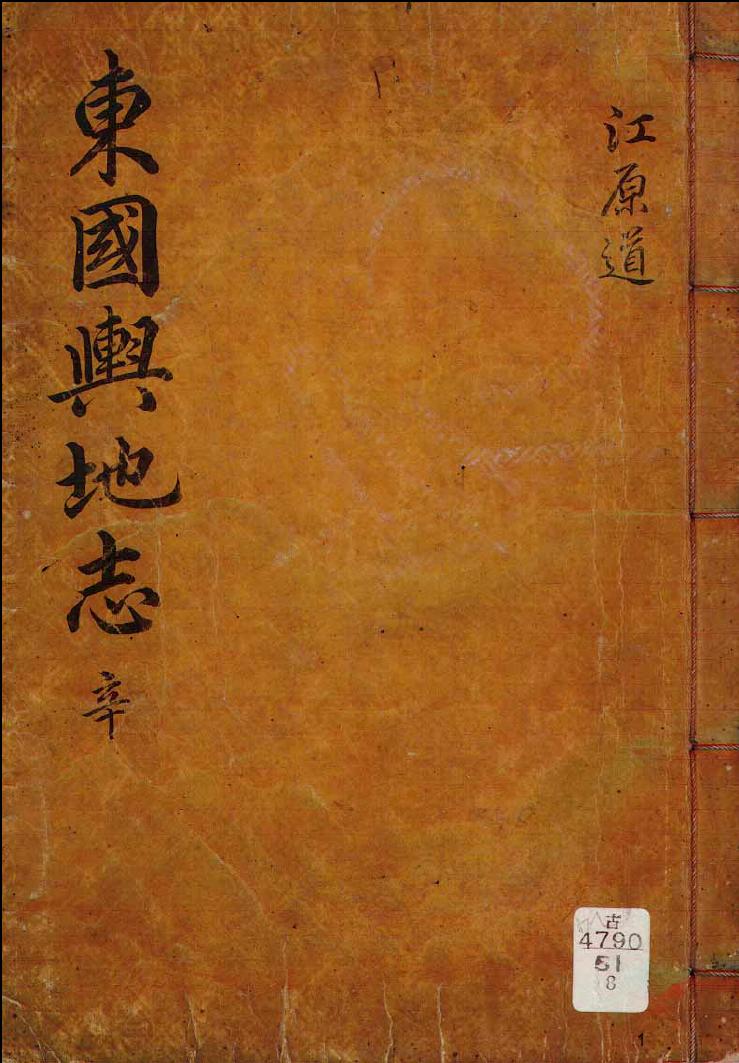
Ryu Hyung-won(柳馨遠 : 1622-1673) is a practical science scholar (実学者 : 실학자) in Choson era. He compiled "東国興地志" or known simply as "Yojiji(輿地志)", the book on a nationwide geography in 1656. ( 柳馨遠's profile from Kyujanggak of Seoul university site : Korean )

Korean have been insisting that Usando was Japanese "Matsushima" (old name for today's Takeshima/Liancourt Rocks/Dokdo) and it is recorded even before Ahn Yon-Bok's smuggling himself into Japan in 1696 and Japanese document Onshu Shicho Goki (隠州視聴合記)(1667), since there are sentence "According to "Yojiji (輿地志)", Ulluen(do) and Usan are all Usanguk. Usan is Japanese so-called Matsushima." in 「東国文献備考・與地考」(1770) or "Mangi Yoram 萬機要覽"(1808). The book "Yojiji" was thought to be long lost in Korea, but Prof. 呉尚学 of Cheju University found it in 2006. Surprisingly, he confirmed that there was no such sentence as "Usan is Japanese so-called Matsushima " in "Yojiji (輿地志)" just as Japanese researchers had always claimed (Shimojo, 2008).

"于山島鬱陵島 一云武陵 一云羽陵 二島在県正東海中 三峯岌嶪撑空南峯梢卑 風日清明則峯頭樹木 及山根沙渚 歴々可見 風便則二日可到 一説干山 鬱陵 本一島 地方百里
(Usando/Ulleungdo are also called both Muleung and U-leung. The two islands are in the middle of the sea due east of the administrative seat. Three peaks shoot straight up to the sky, and the southern peak is a little lower. When it is windy and the weather is clear, you can clearly see the trees on the peaks of the mountains and the sand at their feet. You can travel there in two days with a fair wind. It is said that Usan and Ulleung were originally one island with an area of 100 ri)"(「東国興地志」巻之七 江原道 蔚珍) (Link to the image 1 , 2 )

Apparently, this sentences in "東国興地志" is a copy from "新増東国輿地勝覧".

"于山島鬱陵島 一云武陵 一云羽陵 二島在県正東海中 三峯岌嶪撑空南峯梢卑 風日清明則峯頭樹木 及山根沙渚 歴々可見 風便則二日可到 一説干山 鬱陵 本一島 地方百里"

A clerical error that "According to "輿地志", Usan was so-called Japanese Matsushima", which is actually Ahn Yong-Bok's personal claim started to appear in the books like 「東国文献備考・與地考」(1770) or 「萬機要覧」(1808) after Ahn's Takeshima Incident in 1696. Korean insist that Usando was today's Takeshima/Dokdo based on the sentences from those books. However, if we list related books in order, we can clearly see that Shin Gyong-jun (申景濬), who is the author of 「疆界誌」(1756) and 「東国文献備考・與地考」(1770) inserted his own personal opinion "I think, considering many maps, it must be two island and one of them must be so-called Matsushima" into the middle part of the line "According to "Yojiji" ..." in the former. And he actually altered the sentence as "According to "Yojiji", Usan was so-called Japanese Matsushima" in his next book 「東国文献備考・與地考」(1770). Finally, it started to be requoted by Korean scholars as if it was written in "Yojiji". The books like 「萬機要覧」 and 「増補文献備考 輿地考」, which were published later seems to have succeeded the clerical error by Shin, since the author quoted the sentence in question at second hand, not directly from "Yojiji".

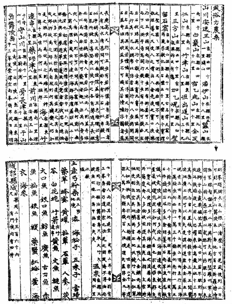
1756 - 申景濬「疆界誌」『旅菴全書』巻之七 「Ganggyego (彊界考) 」十二 鬱陵島

"按 輿地志云 一説于山鬱陵本一島 ( Thinkin about Yojiji, it says that Usan and Ulluen are the same island in one theory,) 而考諸圖志二島也 一則其所謂松島 ( But I think, considering many maps, it must be two island and one of them must be so-called Matsushima,) 而蓋二島 倶是于山國也(and probably two islands are Usanguk.)"

1770 - 申景濬・洪啓禧 「東国文献備考 ・與地考」

"輿地志云 鬱陵 于山 皆于山國地 于山則倭所謂松島也 (Yojiji says that Ulleun and Usan are all Usanguk. Usan is so-called Japanese Matsushima. )"

1808 - 「萬機要覧 軍政篇 (1937 朝鮮総督府)」

"輿地志云 鬱陵于山皆于山国地. 于山則倭所謂松島也" (Yojiji says that Ulleun and Usan are all Usanguk. Usan is so-called Japanese Matsushima. )"

1908 - 李萬運「増補文献備考 輿地考 」

"輿地志云 鬱陵于山皆于山国地. 于山則倭所謂松島也" (Yojiji says that Ulleun and Usan are all Usanguk. Usan is so-called Japanese Matsushima. )"

Now, it is apparent that when Shin(申景濬) compiled "Ganggyego(彊界考)", he inserted his own opinion and conjecture into original sentence. And 14 years later, he fabricated new sentence making it sounds as if it was directly quoted from "Yojiji", which is not true. Then, Korean documents started to follow and copy this fabricated sentence. It is very unprofessional for Korean government and researchers to claim the disputed island as their territory on the basis of apparent clerical error.

1899年9月23日 - 皇城新聞記事「鬱陵島 事況」

Gerryの投稿の日本語訳です。原文はこちら↓(English) 原文画像あり
"Hwangseong Sinmun" (皇城新聞) 1899 Sep 23: Ulleungdo

以下は、韓国皇城新聞1899年9月23日の記事、「鬱陵島 事況」の私の訳です。記事はまず、鬱陵島の全般的な情報を述べ、次に釜山の税関職員だったフランス人ラポルトが、1899年6月末に島の日本人移住民と商人の問題を調査した報告書の、サマリーを載せています。この記事は、9月16日に大韓帝国外部(外務省)が駐韓国日本代表に、鬱陵島の日本人を排除するように要請した後で書かれたと思われます。

この記事は竹島・独島論争において、最初の次の2行があるので特に重要です。

蔚珍の東の海中に鬱陵と呼ばれる島が一つある。その付属の小六島のうち、もっとも顕著なものは、于山島竹島である。

この2行が、竹島論争において特に重要な理由は、鬱陵島の附属島のうち代表的な(最著)島を于山島竹島という二つの名前を列記して表している点です。つまり、1899年のこの記事は、「鬱陵島の附属島のうち代表的な(最著)島は、竹島《日本名竹嶼)という鬱陵島の東沖約2キロに浮かぶ島で、その島は別名于山島である。」と意味していると考えられます。このことは、于山島が現竹島(Liancourt Rocks)の古名であるとの韓国側の主張を、またもや否定する証拠であると言えます。

ところが韓国の歴史学者は、問題の箇所は一つの島を二つの名前で表現したのではなく、二つの別個の島を表していると主張しています。つまり、「附属小六島のうち、最も顕著なものは、于山島と竹島(日本名竹嶼)である。」という意味だというのです。しかし、 "于山島竹島"を"于山島と竹島(竹嶼)"と訳すことの問題点は、 この記事は 他の部分では名詞を羅列するときには、"と (과/와) "や読点(、)がよく使われているのに、"于山島竹島"では"于山島と (과/와) 竹島"のように、二つの名称を分割するための言葉"と (과/와) "が使われていないのです。例をいくつか挙げてみます。

所産은 柴胡, 藁本, 石楠, 香木, 槻木, 蘆竹
産物は柴胡、藁本、石楠、香木、槻木、蘆竹

香木과 蘆竹
香木と蘆竹

船匠商客과 漁人耕夫가
船大工商人と漁師農民

薯와 豆
芋と豆

上年所穫이 薯 二萬包, 大麥 二萬包, 黃豆一萬包, 小麥五千包이오
昨年の収穫は芋二万袋、大麦一万袋、黄豆一万袋、小麦五千袋

材木은 老年巨杉과 各種貴重寶木이 亦多하고
材木は巨木の杉などの各種貴重材が多数

注意して頂きたいのは、上記の例において、3つ以上のものを列挙するときには読点が、二つのものを列挙するときには"と (과/와) "が使われていることで、従来の古文献で通例であった句読点無しの列記を止め、近代的な句読点法を採用しようとしていることが窺えます。つまり、もしこの記者が于山島と竹島(竹嶼)と二つの別々の島であると表示したかったならば、これらの例のように"于山島竹島"のかわりに"と (과/와) "を使用したに違いありません. (例 : 于山島와 竹島)

もちろん、複数の名詞を分けるのに読点が使われていない例も散見されます。しかし、その場合はそれぞれの名詞が意味的に同じか、もしくはまったく違うものか、いずれにせよ名詞間に曖昧さがないのです。しかも、こうした読点や"と (과/와) "が無い例は全て記事の後半、大韓帝国内部(内務省)に提出された報告書、つまり外国語で書かれた文章を官僚が独自の方法で訳したものの要約の中でのみ見受けられるのです。この記事を書いた記者はおそらく内務省の翻訳をそのまま書き写したのでしょう。

"于山島竹島"が2つで無く1つの島を指していることの更なる証拠として、鬱陵島を韓国の江原道の郡の一つに定めた、1900年の大韓帝国勅令第41号が挙げられます。その中では、竹島(竹嶼)は鬱陵島の附属島のひとつとして挙げられていますが、于山島は名前がありません。そのことはつまり、于山島が単なる竹島(竹嶼)の別名であることを示唆しており、韓国の古地図や古文献でもそのことが確認できます。

いずれにせよ、たとえ"于山島竹島"が二つの個別の島を指していたとしても、どちらの島も現竹島(Liancourt Rocks)を指していたことはありえません。というのも、現竹島(Liancourt Rocks)は鬱陵島の最も顕著(最著者)な隣接島ではないからです。実際、現竹島(Liancourt Rocks)が鬱陵島から見えることはめったに無く、稀に気候、天候条件がすべて整った日に高所に登った場合にのみ、ようやく確認できる程度のものなのです。現竹島(Liancourt Rocks)は鬱陵島の東南92kmという離れた距離にある単なる小さな岩礁で出来た島嶼の集まりに過ぎないからです。このような島嶼が鬱陵島の"最も顕著な"隣接島として挙げられるはずがありません。

また、記事では"アシカ(可之)"が"昔は(古에)"鬱陵島に生息していた、と言っており、つまりアシカが1899年にはすでに鬱陵島から消えていたことがわかります。現竹島(Liancourt Rocks)では1899年の時点ではまだアシカが沢山生息していた訳なので、この"アシカ(可之)が昔は(古에)鬱陵島に生息していた"という表現は、この記事の于山島が現竹島(Liancourt Rocks)の事を指していないという、更なる証拠と言えます。

以下にこの記事の翻訳を挙げます。もし間違いを見つけたら、コメントをいただければ幸いです。

別報

鬱陵島 事況

蔚珍の東の海中に島が一つあり、鬱陵という。その附属小六島のうち、最も顕著なのは于山島竹島だ。大韓地誌によれば、鬱陵島は古代の于山国で、広さは百里で、三つの峯が聳えている。

産物は柴胡、藁本、石楠、藤草、香木、槻木、蘆竹だ。土地は大麦に適している。昔は、"可之"と呼ばれる角の無い牛のような水獣(アシカ)が生息していた。(現在?)霍鳥と呼ばれる海鳥も生息している。

島に住む人は少なく、そのため政府は税金の徴収を免除していた。三年ごとに近くの地方官が選任され、島の状況を確認するために派遣されて、香木や 蘆竹を持ち帰って王に献上してきた。

1883年に朝廷は金玉均を東南諸島開拓史兼捕鯨使に任命し、白春培を従事官に任命した。彼らは該島の開拓事務を任されたが、翌年の甲申事変により任務を全うできなかった。その後1888年に(島民の)徐敬秀が越松萬戸(将軍)に任命され、島民人口増加の促進と外国人の材木の違法伐採を防止する任務を請け負った。しかし、徐は翌年大きな効果を挙げることが出来ないまま死去した。

開国504年の1895年、内部(内務省)は住民の裵季周を島監に任命し、島の管理を行わせた。本年春、裵は「最近になって多くの日本人が流入し、樹木を切り倒し、島民の生活を犯し、迷惑をかけ問題を起こしている」と報告し、政府に法律を設定して防護することを求めた。そこで内務省は税関の総税務士、John McLeavy Brown卿(柏卓安)に、西洋人を鬱陵島に派遣して状況を調査するように要請した。

報告書の概要は次のとおりだ。

鬱陵島は二百里程のところにあり、約75平方里ある。全島中耕作地は多く無く、海浜から山嶺まで鬱蒼とした森に覆われている。山の高さは4000フィート(英尺)ほどで、岸から三里内の水深は6000から9600フィートだ。

島の居民は男女300戸で、数十年来、船大工や商人と漁師、農民が少しずつ来島して住み始めた。海岸はの水深は大変深いため、漁業は収益が無く、海藻の出荷は年に2000擔程になる。

土質は肥沃で、肥料は必要ないが、収穫を増やすために木灰がすき込まれる。大麦と小麦が春に、芋と豆は秋に収穫される。昨年の収穫は芋二万包、大麦二万包、黄豆一万包、小麦五千包だった。土地の傾斜がひどく、稲作はできない。材木は巨木の杉などの各種貴重材が多数ある。槻木、香木、柏子木、甘湯木(モチノキ)なども産出する。

本土(大陸)との通商はとても少なく、稀に食料品、煙草、布製品など数袋の物資の輸入があるのみである。輸出は海藻が主であるが、材木やたまに裝(?)もある。

海岸のアシカ峰や岸壁の合間に、100フィートほどの小湾がある。そこで日本の船が米、塩、甕、日本酒、毛布、木綿、ケロシン、マッチ、傘などを輸入品として降ろしている。豆や麦と言った輸出品に加え、全島各地から伐採された材木が(正当な?)対価を払われることなく船に積載されてていく。

日本人が計画的に居住地を作り、(全体で)200名ほどが現地で生活している。現地住民の生活を犯し、上に述べたのと同じような弊害がある。農民や商人は本来免税されているが、島監が海藻の10分の1、材木は船一隻あたり、葉一百兩を徴集している。日本人が商品を売った場合、2%支払うが、納税はしない。

本年9月、内部(内務省)は右の報告に基づき、外部(外務省)に対し、駐ソウル日本公使に状況の改善と僭越日本人の召還を要請するよう要請した。彼等に通商の禁止を約束させ...(最後の一文は不鮮明な為、解読が出来ていません。)

4.5.08

1714 Jul 22: "Visible to the east of Ulleung is an island attached to Japnese territory."

According to a July 22, 1714 entry in King Sukjong's "Bo Gweol Jeong O" (補闕正吳), a Korean government emissary to Korea's Gangwon Province said that the people in the ports there told him the following:

鬱陵之東 島嶼相望 接于倭境
"Visible to the east of Ulleung is an island attached to Japanese territory."
Except for its neighboring islands, the only island visible to the east of Ulleungdo is Liancourt Rocks (Dokdo/Takeshima); therefore, the above sentence is evidence that Koreans in 1714 recognized Liancourt Rocks as being part of Japanese territory. Also, by mentioning the above quote, the Korean emissary seemed to be warning government officials that Japan was within eyesight of Korean territory (Ulleungdo).

Korean historians mistranslate the above sentence, possibly in an attempt to hide the fact that a Korean document described Liancourt Rocks as being Japanese territory, but it seems quite clear to me that this island east of Ulleungdo was not considered part of Ulleungdo since it was described as being visible from Ulleungdo. Also, by only saying that there was an island visible to the east of Ulleungdo, without giving any distance, suggests that they had not been to the island.

HERE is how Korea's National Institute of Korean History translated the passage:
鬱陵之東 島嶼相望 接于倭境
울릉도 동쪽에는 섬이 서로 잇달아 왜경(倭境)에 접해 있다.
East of Ulleungdo, islands connect to each other to reach the Japanese border.
Notice in the above Korean translation that nothing was said about the island east of Ulleungdo being visible from Ulleungdo (鬱陵之東 島嶼相望 ). Instead, they translated 島嶼相望 as being a "chain of islands," which is really ridiculous and something the National Institute of Korean History should be ashamed of. The fact that the National Institute of Korean History came up with such a ridiculous translation stongly suggests that they realized the important of this sentence and how it would hurt the Korean claim to Liancourt Rocks.

This passage is one of only two instances in Korean documents prior to 1906 that mentioned seeing an island east of Ulleungdo that was most likely Liancourt Rocks. The other passage can be found in a 1694 Korean document HERE.

Here is my translation of the relevant passage:
Gangwon Provincial emissary Jo Seok-myeong (趙錫命) discussed the neglected coastal defenses in the Yeongdong region. Here is a summary:
I listened carefully to the people in the ports (浦人) who said, "Pyeonghae (平海) and Uljin (蔚珍) are closest to Ulleungdo, and there are no obstructions along the sea route. Visible to the east of Ulleung is an island attached to Japanese territory." In 1708 and 1712, strange-looking ships drifted to the borders of Goseong (高城) and Ganseong (杆城), so we know that Japanese ships frequently come and go. The government, however, says that the vast sea is a barrier, so there is no need to worry, but how can we be sure that a future war will not break out in the Yeongdong region instead of the Yeongnam region? We cannot allow even a little delay in taking measures to be thoroughly prepared.
In accordance with the request, the Myodang (廟堂) requested that Gangwondo be reprimanded to cracked down on its military officials.

辛酉江原道御使趙錫命 論嶺東海防疎虞狀略曰 詳聞浦人言 平海蔚珍 距鬱陵島最近 船路無少礙 鬱陵之東 島嶼相望 接于倭境. 戊子壬辰 異攘帆穡 漂到高杆境 倭船往來之頻數 可知. 朝家雖以嶺海之限隔 謂無可憂 而安知異日生釁之必由嶺南 而不由嶺東乎. 綢繆之策 不容少緩. 廟堂請依其言 飭江原道 團束軍保.

2.5.08

1899 Sep 23: "Hwangseong Sinmun" (皇城新聞) - Mentions Ulleungdo's neighboring island of Usan (Jukdo)

Below is my translation (with the help of Kaneganese, Chaamiey, and Matsu) of a special report on the Korean island of Ulleungdo (鬱陵島), from the September 23, 1899 edition of the Korean newspaper, Hwangseong Sinmun (皇城新聞). The article gives general information about Ulleungdo and then gives a summary of a report prepared by E. Laporte (羅保得), who worked at the Korean Customs Office in Busan and who went to Ulleungdo at the end of June 1899 to inspect the problem of Japanese settlers and merchants coming to the island. The article seems to have been written after a September 16 request by the Korean Foreign Ministry to the head of the Japanese mission in Korea to have the Japanese on Ulleungdo removed.

The article is important in the Dokdo/Takeshima debate mainly because of the description of Ulleungdo in its first two sentences, which follow:
蔚珍之東海에 一島가 有하니 曰鬱陵이라 其附屬한 小六島中에 最著者는 于山島竹島이니.
There is an island in the sea east of Uljin called "Ulleung." Among its six, small neighboring islands, the most prominent one is Usando/Jukdo.
The above sentence is important in the Dokdo/Takeshima debate because it seems to be using two names, "Usando/Jukdo" (于山島竹島), to refer to Ulleungdo's most prominent neighboring island. In other words, the 1899 article seems to be saying that Ulleungdo's "most prominent" neighboring island of Jukdo, which is about two kilometers off Ulleungdo's east shore, was also called "Usando," which would be more evidence disproving the Korean claim that Usando was the old name for Liancourt Rocks (Dokdo/Takeshima).

Korean historians, however, claim that the above sentence was not referring to one island with two names, but to two separate islands. They claim that the sentence should be translated as, "Among its six, small neighboring islands, the most prominent ones are Usando and Jukdo." The problem with translating "于山島竹島" as "Usando and Jukdo," is that the Korean article did not use the word "and" to separate the two names, even though the word "and" (과/와) and commas were used to separate list items in other parts of the article. Here are some examples:
  • 所産은 柴胡, 藁本, 石楠, 藤草, 香木, 槻木, 蘆竹
    Its products are siho, gobon, seoknam, wisteria, juniper, zelkova, nojuk....
    .
  • 香木과 蘆竹
    juniper and nojuk

  • 船匠商客과 漁人耕夫가
    shipbuilders/merchants and fishermen/farmers

  • 薯와 豆
    potatoes and beans

  • 上年所穫이 薯 二萬包, 大麥 二萬包, 黃豆一萬包, 小麥五千包이오
    Last year's harvest was 20,000 po of potatoes, 20,000 po of barley, 10,000 po of yellow beans, 5,000 po of wheat.

  • 材木은 老年巨杉과 各種貴重寶木이 亦多하고
    The are many wood products, including Japanese cedar and a variety of rare, valuable trees.
Notice in the above examples that commas were used to separate three or more list items, and an "and" (과/와) was used to separate two list items, which show us that the reporter was trying to follow modern punctuation rules rather than leaving list items unpunctuated, as was the case in older Korean documents. Therefore, if the reporter had wanted to refer to Usando and Jukdo as two separate islands, the above examples suggest that he would have used an "and" between Usando and Jukdo (e.g. 于山島와 竹島), instead of Usando/Jukdo (于山島竹島).

There are a few examples in the text where commas were not used to separate list items, but in those cases, there is no ambiguity since the words were either idiomatically linked together or were obviously separate list items. Moreover, the instances of the unpuncuated list items all occured in the last half of the article, which is a summary of the report submitted to the Korean Ministry of Interior, where officials there may have translated the foreign language report using their own style of punctuation. The reporter who wrote the article may have just copied directly from the Ministry translation.

More evidence that the "Usando/Jukdo" (于山島竹島) reference in the article was referring to one island, not two, is Korea's 1900 Imperial Edict 41, which made Ulleungdo a county of Korea's Gangwon Province. In that edict, Jukdo was mentioned as one of Ulleungdo's neighboring islands, but not Usando, suggesting, again, that Usando was just an alternate name for Jukdo, which is supported by several old Korean maps and documents.

At any rate, even if the "Usando/Jukdo" (于山島竹島) phrase had been referring to two separate islands, neither of the islands would have been Liancourt Rocks since Liancourt Rocks is NOT one of Ulleungdo's "most prominent" (最著者) neighboring islands. In fact, Liancourt Rocks can very rarely be seen from Ulleungdo, and then only from high elevations when atmosperic conditions are just right. That is because Liancourt Rocks is just a very small grouping of rocky islets ninety-two kilometers southeast of Ulleungdo. Such islets would not have been referred to as one of Ulleungdo's "most prominent" neighboring islands.

Also, the article said that "sea lions" (可之) "used to" (古에) live on Ulleungdo, which means they were no longer living on Ulleungdo in 1899. Since sea lions were still living on Liancourt Rocks in 1899, the sentence in the article saying that sea lions "used to" live on Ulleungdo is more evidence that the Usando mentioned in the article was not referring to Liancourt Rocks (Dokdo/Takeshima).
Below is my translation of the article and the article, itself. If you find any errors or have any suggests for improving it, please let me know in the Comments section. (Click twice on the article below to enlarge it.)
----------------------------
Special Report (別報)

Ulleungdo Situation (鬱陵島 事況)

There is an island in the sea east of Uljin called "Ulleung" (蔚珍之東海에 一島가 有하니 曰鬱陵). Among its six, small neighboring islands (其附屬한 小六島中에) the most prominent one (最著者는) is Usando/Jukdo (于山島竹島이니). According to the Daehanjiji (大韓地誌에 曰), Ulleungdo is the old country of Usan (鬱陵島는 古于山國이라). It has an area of 100 ri (地方이 百里오) and three peaks that stand out (三峰이 律兀한되).

Its products are (所産은) siho (柴胡 – bupleurum root), gobon (藁本 Ligusticum sinense Oliv. root), seoknam (石楠 – Photinia serrulata Lindl), wisteria (藤草), juniper (香木), zelkova (槻木), and nojuk [(蘆竹 - a reed-like bamboo)이오]. The land is suitable for barley (土性은 宜麥하고). In the past (古에), there were water animals that looked like cows without horns that were called “gaji” (牛形無角한 水獸가 有하니 名曰可之오). There are also seabirds that are called "gwakjo" (海鳥가 有하니 名曰 霍鳥러라).
There are few people on the island (島中에 人烟이 稀少하야), so the government exempts them from paying tax (國家에서 公稅를 免徵하고). Every three years (每式年에), the authority in the neighboring region (附近地方官으로) selected and sent emissaries (差使員을 定送하야) to inspect the situation on the island (島中情形도 査察하고) just bring back juniper and nojuk to present to the king (香木과 蘆竹을 裁還하야 御貢할 뿐이러니).

In 1883 (癸未年에), the royal court (朝廷에서) appointed Kim Ok-gyun as the Southeast Islands Development & Whaling Official (金玉均으로 東南諸島開拓史兼捕鯨使를 任하고) and appointed Baek Chun-bae as his assistant (白春培로 從事官을 任하야). They were given the task of settling the island (該島開拓事務를 辦理케하였더니), but because of the Gapshin Coup the following year (翌年 甲申의 變을 因하야), they could not achieve much (泰效치못하였고). Afterwards, in 1888 (其後戊子年에), island resident Seo Gyeong-su was appointed Wolsong Commander and given the duty of increasing the island’s population and preventing the illegal harvesting of the island’s forest by foreigners. (島民徐敬秀로 越松萬戶를 差定하야 該島人民을 繁殖하고 外國人의 樹木侵伐하는 弊를 防禦케 하였더니), but Seo Gyeong-su died the following year before completing the job (翌年에 徐敬秀가 身死未遂하였고).
In 1895 (開國五百四年에), the Ministry of the Interior appointed island resident Bae Gye-ju as the Island Supervisor and had him manage the island (內部에서 本島民 裵季周로 島監을 任하야 島務를 管理케하였더니). 
 In the spring of this year (1899), Bae Gye-ju reported to the Ministry of Interior that Japanese had recently been arriving in large numbers and were cutting down trees, encroaching on residents, and causing disturbances (本年春에 裵季周가 內部에 來報하되 近者에 日本人이 夥數流入하야 樹木을 斫伐하고 居民을 侵擾하니), and requested that the government establish law and order (政府에서 設法防護하기를 請함의), which prompted the Interior Ministry to request Sir John McLeavy Brown, chief commissioner of the Korean Customs Service, to dispatch one Westerner to the island to investigate the situation there (內部에서 海關總稅務士 柏卓安에게 委託하야 西人一員을 派送하야 該島情形을 査報케 하였더니). A summary of the report follows (其報告의 槪況이 如左하니):

Ulleungdo is about 200 ri from land (鬱陵島는 距陸二百餘里오). It has an area estimated to be about seventy-five square ri (面積은 約計 七十五方里니). The entire island had little cultivated land (遍嶋中에 耕植하는 地는 不多하고), and there was a thick forest of trees from the seashore to the mountain ridge (樹木이 海濱으로 從하야 山嶺까지 鬱密하였는되). The height of the mountain is calculated to be 4,000 English feet (山高는 計有四千英尺이오). The depth of the water within three ri of the shore is between 6,000 and 9,600 English feet (距岸三里內의 水深은 自六千至九千六百英尺이라).

There are about 300 families of men and women living on the island (居民은 男女 約 三百口이니). Over the past couple of decades (數十年來로), shipbuilders/merchants and fishermen/farmers have gradually come to live together on the island. (漸次 船匠商客과 漁人耕夫가 相隨而至하야 居生하는되). Since the water is extremely deep, it is said that fishing is unprofitable, but annual shipments of seaweed reach as much as 2,000 dam (海水가 太深하야 魚産은 未益하고다만 海菜의 運出이 每年에 二千 擔에 多至하고).

The land is fertile, so fertilization with night soil is unnecessary (土質은 膏沃하야 糞漑 를 要치아니하고), but wood ash is plowed into the fields to achieve two harvest a year (樹叢燼灰로 覆耕하야 一年兩熟을 得하니). Barley and wheat are planted in the spring (春季에는 大小麥이오), and potatoes and beans in the fall (秋季에는 薯와 豆인 되). Last year’s harvest was 20,000 po of potatoes, 20,000 po of barley, 10,000 po of yellow beans, and 5,000 po of wheat (上年所穫이 薯 二萬包, 大麥 二萬包, 黃豆一萬包, 小麥五千包이오). The incline of the land is too steep to grow rice (地勢가 太斜하야 禾穀은 耕作지 못 하고). There are many wood products, including old, large Japanese cedar and a variety of rare, valuable trees (材木은 老年巨杉과 各種貴重寶木이 亦多하고). There are zelkova, juniper, pine nut, and Integra holly (槻木 香木 柏子木 甘湯木이 産有하어라).

Trade with the mainland is extremely rare, but they occasionally get a shipment of only a few po of such things as foodstuff, tobacco, and cotton cloth (大陸과 通商이 極少한 되 往往히 商簇의 輸入하는 物貨는 食物烟草布疋 等數包 뿐이오.) The goods they ship out is mainly seaweed, but also lumber, and occasionally clothes (其 載出하는 物品은 海菜가 居多하고 板木 間或 裝 運하더라).

Among the confusion of rock cliffs at the shoreline of Seal Peak (嶋邊海狗峯石壁亂叢中에), there is a small inlet about 100 English feet wide (一小灣이有하니 約闊一百 英尺이라), where Japanese ships loaded with such imports as rice, salt, pottery, Japanese wine, wool, cotton cloth, kerosene, matches, and umbrellas trade with the locals using the barter method (該灣으로 日本船商의 輸入品은 米 塩 瓷器 日本酒 洋布 木綿 火油 火柴 雨傘等件인되 土民으로더부러 交易하는 法은 物로物을易하고). Besides beans and barley, the exported goods include wood that is cut indiscriminately from all over the mountain, loaded onto ships, and carried away--the price is insufficient (其輸出品은 豆麥外에 満山材木을 亂斫鋸削하야 船隻에 載往하는者--其値가 不實하고).

There are places on the island where about 200 Japanese have built houses and are living temporarily (本嶋中에 築室旅居하는 日本人이 二百餘名인되). They encroach on the locals and have inappropriate relations (土民을 侵凌하야 相関하는 弊가 有하어라). The farmers and merchants are originally not taxed 農民商民의 公税는 原定함이 無하고), but, the island supervisor is collecting one-tenth of the seaweed (但 嶋監이 海菜에는 十分의一을 徵하고) and a wood charge of 100 ryang per ship (木料에는 毎船一隻에 葉一百 兩을 徴하여). When the Japanese sell goods, they pay only a negotiated fee of two percent, but no tax (日本人은 賣貨時 口文(百抽二)外에는 納税함이 無하더라).

In September of this year, the Interior Ministry (本年九月에 内部에서), based on the above report (右項報告을 等因하야), requested that the Foreign Ministry request the head of the Japanese mission in Korea (外部에 照會하였더니 外部에서 駐京日本公使에게 照會하야) to promise to set a date to remove the Japanese trespassing on the island (該嶋에 潜越한 日本人을 訂期刷還하고) and stop and prohibit the stuggling trade from non-trade ports. (不通商港口에 密輸買賣함을 禁戢케하라하였더라).

1.5.08

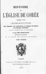
1874 - "Histoire de L'Eglise de Corée" by Claude Charles Dallet

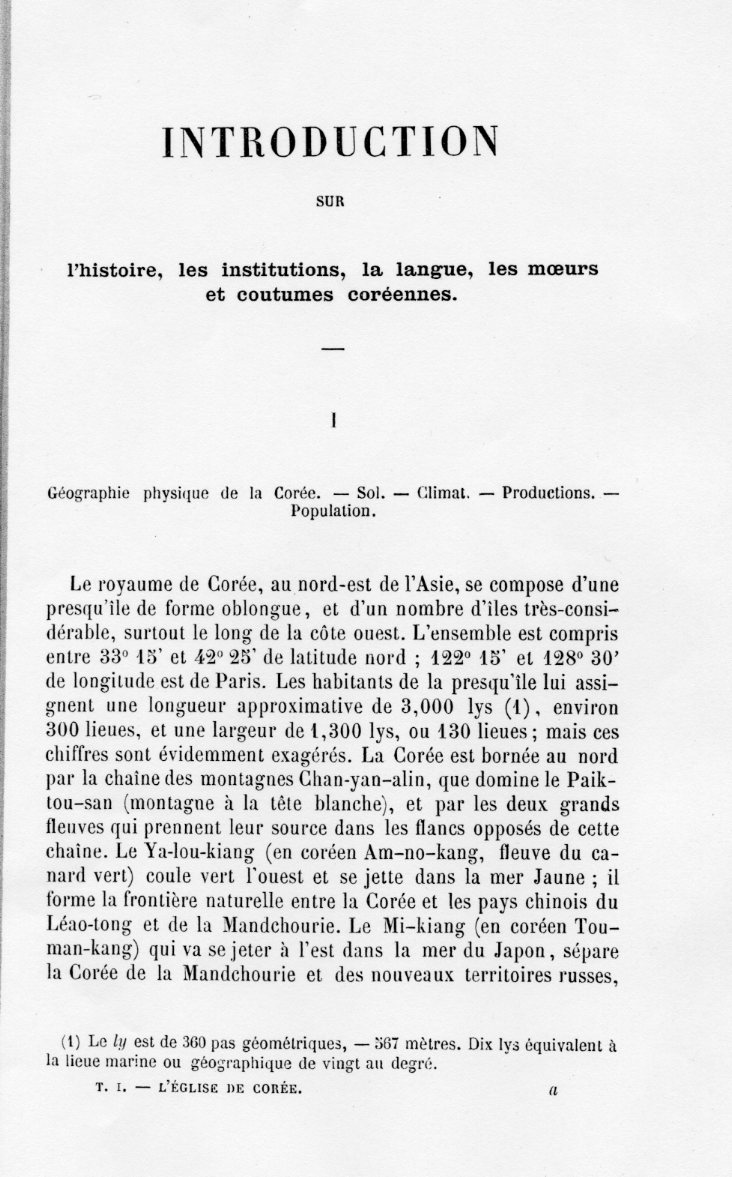
Fr. Claude-Charles Dallet described eastern limit of Korea as 130°50’E, which exclude Takeshima/Dokdo in his book "Histoire de L'Eglise de Corée (History of the Korean Catholic Church). "(1874).

"Histoire de L'Eglise de Corée" (1874)

Geographie physique de la Corée Le royaume de Corée, au nord-est de l'Asie, se compose d'une presqu'île de forme oblongue, et d'un nombre d'îles très-considérables, surtout le long de la côte ouest. L'ensemble est compris entre 33°15’ et 42° 25’ de latitude nord ; 122° 15’ et 128°30’ de longitude est de Paris. ( 128°30’ E+ 2°20’(Eastern longitude of Paris) = 130°50’E (Greenwich Meridian))

1874 Histoire de l'eglise de Coree_longitude

(Links to the full page)

Moreover, the map attached to this book clearly depicts "Ou-san(Usan)" next to "Oul-leng-to (Ulleundo)", the exact location of today's Jukdo, not today's Takeshima/Dokdo which locates at 131”50’E. Besides, you can clearly see that "Oul-leng-to (Ulleundo)" and "Ou-san(Usan)" consist one "Dagelet Island". Liancourt Rocks were never thought to be Dgelet island. Notice that the map also includes lines of longitude and latitude, which eliminate any possibility that “Ou-san” could have been referring to Liancourt Rocks (Dokdo) (Lies, Half-truths, & Dokdo Video, Part 7). Those facts show French who saw Korean old maps and western maps considered Usando is today's Jukdo, just like us. It coincide with the fact that there is no single document that show Korean themselves thought Usando is today's Takeshima/Dokdo, but a neighbouring island of Ulleundo.

Dallet explains about the map as follows. (Thanks to matsu for the information.)
Celle que nous donnons en tête de cet ouvrage a été dressée, pour le littoral, d’après les cartes du dépôt de la marine, et pour l’intérieur du pays, d’après une carte indigène assez récente, tranduite par Mgr Ridel, vicaire apostolique de Corée.

(The coastal place of this map was made by the maps of Navy and inland was by the vicar apostolic Ridel's translation of relatively recent map by local. )

This is very important for the Takeshima/Dokdo dispute since the islets "Liancourt Rocks" were re-found and already charted by the French whaling ship Liancourt in 1849. In other words, this map proves even french Navy was almost certainly recognized "Usando" was Jukdo, not Takeshima/Liancourt Rocks/Dokdo and excluded the islets from Korean territory.

Supplement

Below are the informations on the author Dallet and this book I found on the net.

Claude-Charles Dallet was born in Langres, France, 18 October 1829. He entered the Se'minaire des Missions E'trange`res in 1850, and was ordained 5 June 1852. Though he spent his missionary life mainly in Asia, including India, he had never been to Korea. This book is mainly based on the materials collected by Msgr. Daveluy who was executed in Seoul in 1866.

Charles Dallet wrote this book, as he very clearly spells out in his preface, on the basis of letters and other communications received in Paris between 1836 and 1863 from the missionaries in Korea. In what must have been an intricately planned operation, Korean Catholic fishermen took the mail out to sea and passed it to Chinese Catholic fishermen who took it to Shanghai, whence it was dispatched to Hong Kong, where the Societe' des Missions E'trange`res had an agent, who posted it to Paris. This route was apparently pioneered and developed by Kim Tayken, Korea's first Catholic priest, who studied and was ordained in China. From 1836 on, all French priests who entered Korea, or in 1866 those who fled it, did so by sea. The Korean authorities had long since established virtually impenetrable security at the northern frontier, at least in so far as Europeans were concerned. (Gari Ledyard , Wiki : Japanese )

1874 Histoire de l'eglise de Coree_top

1874 Histoire de l'eglise de Coree_bottom