4) 『鬱陵島外図』
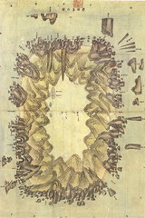 It is a map made by 李奎遠, who was dispatched as a prosecutor to Ulleundo by Choson dynasty in 1882. It is which it uses and is sent in 1882. It is currently owned by Kyujangkak of Korean study center, Seoul National University. It can be said that this drawing is a government manufacture map, either.
The document 『鬱陵島検察使日記 (Diary of the inspector to Ulleundo)』 which was made along with this map says that "The islands like Matsu/Take/Usando etc. are all meant to be the small island (of Ulleundo) by the locals. But the neighbouring islands of Ulleundo in this map are only "島頂" and "竹島", and if you compare this map to the present map of Ulleundo, "島頂" is a Kwannundo(観音島) and "竹島" is Jukdo(竹嶼, Korean name 竹島). In a word, it is apparent that inspector 李奎遠 did not investigated present Takeshima/Dokdo at all.
The longtime empty island policy of Ulleundo was ceased by Choson dynasty, and the development of Ulleundo was started in 1882. Thus, it can be said that present Takeshima/Dokdo was not recognized geographically nor furthermore considered to be within their territory by Choson dynasty even when it arrived at time the development of Ulleundo was started in late 19th century.
*Related articles
1882 April 7 - King Kojong says Usando Neighboring Island of Ulleungdo (高宗 19卷, 19年 4月 7日 壬戌)
Lies, Half-truths, and Dokdo Video, Part 3 : 1786 Ulleungdo Inspection : 日省録(1786), 海東地圖(1750 c.a.), 鬱陵島外圖(1882)
Lies, Half-truths, and Dokdo Video, Part 5 : "The King, Lee Gyu-won & Many Names for a Neighboring Island" 高宗19年(1882), 靑邱圖(1834), 英海軍地図(1863), 大日本国沿海略図(1867), 「松島開拓之議」(1877/8), 軍艦「天城」作成地図(1880)
Lies, Half-truths, and Dokdo Video, Part 6 : 海東地圖(1750's), 靑邱圖(1834), 韓国古地図(1800's), 鬱陵島外圖(1882), 日本古地図(1886), 鬱陵島見取図(1905), 韓国水産誌「鬱陵島全図」(1909)
Lies, Half-truths, and Dokdo Video, Part 8 : "An Yong-bok, Usando, & Matsushima (Songdo)" 肅宗実録(1696), 鬱陵島圖形(1711), 鬱陵島事蹟(1694), 海東地圖(1750s), 輿地圖(1736-67), 朝鮮地圖(1750-1768), 地乘(1776-1800), 東國文獻備考(1770), 日省録(1793), 萬機要覽(1808), 靑邱圖(1835), 朝鮮国交際始末内探書(1869), 高宗実録(1882), 鬱陵島外圖(1882), 大韓全図(1899), 皇城新聞(1899), 大韓勅令勅令第41号(1900)
Lies, Half-truths, and Dokdo Video, Maps 2 : "1882 Ulleungdo, an outside view & Seal Cave" 鬱陵島外圖(1882)
「朝鮮側作製の官製地図にみる竹島(Takeshima in the Korean official map)」 by associate professor Funasugi Rikinobu (舩杉力修) of Shimane University.
Translated by Kaneganese.
Courtesy of Web Takeshima Research Center.
Gerry and pacifist,
ReplyDeleteCould you please check my translation when you have time? Thank you.
Do you have a clear image of 鬱陵島内圖 with the each place of name confirmed?
ReplyDeleteBy the way 船板邱尾 named after the mix name between 船泊䖏 and 刻石立標? How do you think
ReplyDeleteIs this rock in front of 錘山 is 門城 on which drawn on the Ulluengdo mainland some detailed Ulluengdo map instead of true Gong-am=Hole Rock?
ReplyDeleteThere are Gajaegul可支窟 southwest of Ulluengdo.
ReplyDelete"1"On the Ulluengdo tourist map says Gajaegul is "no6" in the brosure and I remember it was between namyandong and Tonggumi.
http://www.panoramio.com/photo/26201060
"2"But 鬱陵島外圖 gajaegul on bit north of Saja bawi (Namyangdon) , maybe around 水層洞
http://www.panoramio.com/photo/26122523
I guess Sea lion cave on 1882 woul be "2"
Between Seommok north to Samseon Rock nearby the "Angel's pool" and "candle stick rock(this candle stick is different with Samseon Rock)" , there are small tunnel and inside tunnel there are big cave.
ReplyDeleteI guess it is 岩間朱穴
Location is here :http://www.panoramio.com/photo/26068197
Anyone know this Rock name nearby Dodong?
ReplyDeletehttp://www.flickr.com/photos/malpuella/2862014476/
Which rock are you talking about? BTW, all of her photos are gorgeous. Thank you for showing the site, GTOMR.
ReplyDeleteCan you see one candle-stick/pole like rock here?
ReplyDeleteI saw this rock and it is prominent rock ,view from the sea.
http://www.flickr.com/photos/malpuella/2862014476/
I was looking at the ocean. That is a weird shape. I don't think of any rock in the old map, though.
ReplyDeleteThis comment has been removed by the author.
ReplyDelete老姑岩 is Bukmyong北芋岩 and 槍岩 would be Chodatae燭臺 in front of 芋浦
ReplyDelete北芋岩
http://www.panoramio.com/photo/26069593
http://www.panoramio.com/photo/26069806
http://www.panoramio.com/photo/26025633
燭臺
http://www.panoramio.com/photo/26069537
http://www.panoramio.com/photo/26025773
But, I couldnt confirmed which rock is 冑岩(Bit southwest of 道方廳,maybe dodong)and 将軍岩 between 芋浦 and 道方廳.Im not sure those are destroyed or extinct.
There are only two prominent rock southeast coast would be, but it is no concrusion yet.
1.The standing rock on the cliff
http://www.flickr.com/photos/malpuella/2862014476/
2.Sure bawi 水雷岩
(1928)
http://www.panoramio.com/photo/26641080 a rock nerby sadong or sinri 1
http://www.panoramio.com/photo/26641048 a rock nearby sagong or sinri 2
Judging from the shape of the 雄通邱尾 ,I think it is the coast line from Seommok North to Samseon Rock incruding Angel pool nearby deversion to Seokpo.
ReplyDeleteAlso,船板邱尾 would be South face of Seommok or Wadarri.
1882.
http://maps.google.co.jp/maps/ms?hl=ja&client=firefox-a&ie=UTF8&msa=0&msid=110845156839716248106.000473800c78b967f1a4f&t=h&z=12
cf:http://www.occidentalism.org/?p=333
This comment has been removed by the author.
ReplyDeleteThis comment has been removed by the author.
ReplyDeleteGajaegul describes southewest of 鬱陵島外圖
ReplyDeleteUllengdo tourist information, they explain that Gajaegul is No.6 of their blosure.
http://www.panoramio.com/photo/26201060
But, I saw this place is between Tonggumi and Namyangdong
http://www.panoramio.com/photo/26022573
But...considering the position of Gajaegul ,it is described at the north of Saja bawi,The Gajaegul on 鬱陵島圖形 is different from Tour Map one, maybe it is around 窟巖 and 水層洞 like this、
http://www.panoramio.com/photo/26122523
http://www.panoramio.com/photo/26122623
http://www.panoramio.com/photo/26122578
By the way maybe everyone knows this 鬱陵島外圖 and 桧垣's Ulluengdo detailed map is almost match with information.
http://dokdo-or-takeshima.blogspot.com/2007/10/map-of-ulleungdo-1883.html
http://maps.google.co.jp/maps/ms?ie=UTF8&hl=ja&msa=0&msid=110845156839716248106.000473807c31e0f8dd74e&t=h&z=12