5)『大韓全図』、『大韓輿地図』
Both "大韓全図" and "大韓輿地図" were published by the faculty of the editing bureau, the Ministry of Education of the Great Korean Empire. The faculty was set up within the government office to rule the school affairs administration in 1895. There were secretariat, a school affairs bureau, and an edit bureau in the faculty, and it had jurisdiction over climate observatory, 成均館(University), the teacher-training school and the junior high school etc. Therefore, it can be said that this map is a government manufactured official map again.
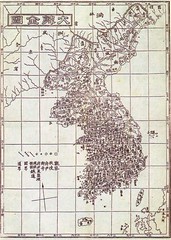
"大韓全図" is a publication in 1899, and the one that latitude and longitude was written for the first time in a Korean complete map. In this map, Ulleundo is recorded, as well as a current Korean map, at the west side and Usando was placed next to the Ulleundo on the east side. In "大韓地誌"published in the same year, the east limit of Korea is declared to be Ulleundo(130° east). The map and the document confirm that the east limit of Korea in 1899 was Ulleundo since present Takeshima/Dokdo locates at 131°52".
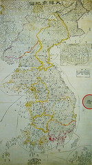
"大韓輿地図" is assumed to be publication in about 1900. Ulleundo is recorded at the west side and Usando was placed next to the Ulleundo on the east side just like the description of "大韓全図". South Korea claims that they had promoted the Ulleundo to the county, making "石島", which South Korea insists to be present Takeshima/Dokdo, within their territory at the same time by the Imperial Ordinance No.41 in October, 1900. However, neither "石島" nor the description of Dokdo are seen on the map, though the phantom island in the south of Ulleundo is recorded and Usando as neighbouring island of Ulleundo at the east side. It is thought that having recorded the island in the south of Ulleundo referred to the maps such as "朝鮮地図".
As we had seen so far, Korean official maps doesn't have recorded present Takeshima/Dokdo even immediately before Japan incorporates present Takeshima/Dokdo into Shimane, Japan (1905). Prof, Hosaka claims that Japanese official maps in Edo and Meiji era don't include Takeshima/Dokdo, but none of Korean official maps actually didn't drawn Takeshima/Dokdo at all.
*Related articles
1899 Korean Map: "Daehanjeondo" (大韓全圖) (玄采 大韓地誌)
1900 - Imperial Edict Makes Ulleungdo a County of Gangwon Province (大韓勅令第41号)
Lies, Half-truths, and Dokdo Video, Part 8 : "An Yong-bok, Usando, & Matsushima (Songdo)" 肅宗実録(1696), 鬱陵島圖形(1711), 鬱陵島事蹟(1694), 海東地圖(1750s), 輿地圖(1736-67), 朝鮮地圖(1750-1768), 地乘(1776-1800), 東國文獻備考(1770), 日省録(1793), 萬機要覽(1808), 靑邱圖(1835), 朝鮮国交際始末内探書(1869), 高宗実録(1882), 鬱陵島外圖(1882), 大韓全図(1899), 皇城新聞(1899), 大韓勅令勅令第41号(1900)
Lies, Half-truths, and Dokdo Video, Part 11 : 大韓全図(1899), 大韓新地誌(1907), 崔南善「朝鮮常識問答」(1946) 「朝鮮常識」(1948)
「朝鮮側作製の官製地図にみる竹島(Takeshima in the Korean official map)」 by associate professor Funasugi Rikinobu (舩杉力修) of Shimane University.
Translated by Kaneganese.
Courtesy of Web Takeshima Research Center.
Gerry and pacifist,
ReplyDeleteCould you please check my translation when you have time? Thank you.
Kanganese. Look closely at the maps you are citing and note the similarities.
ReplyDeleteFirst we know these maps are not based on surveys of Ulleungdo. This is because they show the same errors of ancient maps of Ulleungdo. Can you see the five islands to the South of Ulleungdo? These islands do not exist, thus we know the maps are inaccurate.
Secondly note the position and size of Ulleungdo Island. Ulleungdo is drawn far too West and much too large. These maps are not accurate representations of latitude or longitude or geographical features. By the way, we also know these maps were drawn as a combination of copies of Japanese maps and old Korean maps as well, so don't hold them as accurate representations.
Once again the Takeshima lobbyist have failed. But then what should we expect from the Takeshima Retard Center? This is because they have attempted to narrow this Takeshima issue into the Usando issue instead of approaching the problem from a truly balanced historical study of the dispute. That is whatever historical references prove the identity of Usando (either way) they'll never resolve the conflict.
Steve Barber,
ReplyDeleteAre you proud of inaccuracy of Korean map making? It sounds strange.
Anyway, if it has inaccurate information about the islands including Ulleungdo, it may mean Korea didn't effectively control the area.
The tiny islets around Ulleungdo were drawn because ancient maps of Ulleungdo had the same islets - 6 islets with the biggest (prominent) island Jukdo (not Liancourt rocks).
Korea in those days knew its territorial range and it excluded Liancourt rocks. Steve, this is a fact. Look at the facts, Steve.
Pacifist, I'm not "proud" of Korean mapmaking. I'm merely pointing out historical facts regarding the disparity of development and technology between Chosun and Japan around 1900. I also believe there was a difference between the level of cognizance between Korean residents on Ulleungdo and the central Chosun government itself.
ReplyDeletePacifist, look at the facts yourself. Shim Heung Taek the governor or Ulleungdo considered Dokdo part of his county when he expressed his shock when he found out Japan had annexed Dokdo.
Korean limits
Look at the facts as to how Japanese expansionists pushed forth the annexation of Liancourt.
Japanese Expansionism
Why don't you pass the above links to your fine right-wing friends at Shimane Prefecture Headquarters. Tell them the public now knows the truth about Japan's military and expansionist policy in 1905.
Korean limits
ReplyDeleteSteve Barber,
ReplyDeleteYou should admit that Korea in those days didn't control the islands effectively - they lacked in information about the islands so that they had to make the map as old maps.
And Shim Heung Taek himself lacked in accurate information. It is clear that he didn't know exactly about the Korean territory. It was his mistake to understand Dokdo (Liancourt rocks) was Korean territory, while the official maps of Korea denied that. So his vague knowledge led to the uncertain information.
His report was sent to the local government, and the local government didn't have accurate information about Dokdo too so they sent the carbon-copied report to the central government. So Shim's mistake was the beginning of the turmoil but that doesn't mean that Dokdo is Korean territory.
Pacifist, Shim Heung Taek was not a surveyor. Sure is location was off on his report, however, we can say with 100% certainty that Koreans on Ulleungdo were aware of Liancourt Rocks at least 5 years before the Japanese annexed the island. This is very important.
ReplyDeleteDo you want to start me on "international law" and Japan's 1905 annexation of Liancourt Rocks? Sure I'll bite.
First, Japan claimed Liancourt Rocks on the basis of occupation. This is despite the fact Nakai Yozaburor was not occupying the islands at all. He was conducting his business (illegally) from Korea's Ulleungdo Island.
The January 1905 cabinet decision stated he had moved to the island. However, logbooks of the warship Tsushima's November survey show there was no structure on Liancourt at all, it was destroyed. This "occupation" surely wasn't "continuous" Nakai (and possibly Koreans too) only visited Liancourt for 10 days at a time and only during 2 months a year. Claiming "occupation" on islands that are inhabitable is a dubious claim at best.
Japan's claim was not "open and public" The announcement made by Shimane was inadequate. It was on the second page of a local newpaper. In fact, there was no mention of the islands internationally recognized name (Liancourt Rocks). There was no mention at a central government level and it was not published in the official gazette.
Japan says the newspaper article was "public" but we have to clarify what is public? A Korean legal scholar puts forth a reasonable definition.
The display of sovereignty should be open and public enough to solicit the attention of any sovereigns interested in the territoriality over a particular land, and thus sufficient enough for the acquisitioning State to legitimately claim the acquiescence or recognition of other sovereigns over its newly established territoriality.
A unilateral and stealthy occupation by one sovereign of a territory, without any external manifestation in total disregard of any potential objecting State may not obtain the sanction of international law.
Seriously how would any other interested sovereign have known Japan annexed Liancourt Rocks when we see their shabby "public" announcement?
Expansionist Politics and Dokdo
Steve Barber,
ReplyDeleteI will tell you about the international law.
There are 5 ways to acquire territory as follows:
(1) assignment (alienation)
(2) conquest* (*this way is now unlawful under the United nations Charter)
(3) occupation before others
(4) attachment
(5) prescription
For example, Alaska was a case of (1). In the case of Takeshima, the (3) was the reason of ownership under the international law.
To get a territory with the way of (3), a nation has to show a will to get the land of terra nullius and show effective control over the place after that. Nowadays, the effective control is regarded as the most important thing.
More precisely, (A) a nation has to have a will to get the land, (B) the nation has to show her will to get the land, (C) the land should be terra nullius, (D) the nation has to occupy the land or has to admit that people of her country occupying the land.
Japan did a Cabinet meeting and decided to incorporate Liancourt rocks, so (A) and (B) were fulfilled. Liancourt rocks were out of Korean territory as we have proved in this blog, so the (C) was fulfilled. As to the occupation, Nakai Yozaburo built a hut, brought fishermen and engaged in sealion hunting there, so the (D) was fulfilled. Occupation doesn't always mean to live there. Nakai was not living there but his main working place was there and men and women were going in and out from Liancourt rocks - these circumferences may mean occupation. Truly, some Koreans were among them but they were hired and brought to the place by Japanese.
And after these terms fulfilled, Japan effectively control the island - the chief of prefecture made round inspections etc.
Looking back at Korean side, they need to use the term (2) or (5) to get Liancourt rocks (Dokdo) under the international law but (2) is now denied by the United Nations Charter, so they has to use (5) but prescription won't happen while one of other nations keeps claiming.
Japan still keeps claiming to the unlawful deed, so Korea has no right to own Liancourt rocks under the international law.
You got it, Steve?
Pacifist, if you are going spout off legal theories please cite your references instead of pretending to be Perry Mason. The basic methods of territorial acquisition according to this legal website are as follows:
ReplyDeleteA. Treaty Law B. Geography C. Economy D. Culture E. Effective Control F. History G. Uti Possidetis H. Elitism I. Ideology
Legal Link
got it?
Pacifist as you mentioned Nakai Yozaburo didn't live on Liancourt. However, Shimane's announcement stated he did which we know was not true.
Second, occupation means just that "occupying" meaning continously maintaining person or structure. What presence did the Japanese have on Liancourt Rocks to justify this premise? Nakai Yozaburo had his base on Ulleungdo (illegally squatting) NOT Takeshima like you say. Nakai only visited Liancourt Rocks a few times and only during June or July. This can be seen in the logbooks of the Japanese warship Niitaka in September 1904.
As for any evidence of structures, as I've mentioned this so-called fishing building was just a pile of ruins as described in the 1904 survey by the warship Tsushima in November 1904. Nakai Yozaburo hadn't visited Liancourt Rocks since probably the last summer.
To summarize there were no signs of "occupation" by Japanese on Liancourt Rocks at the time when Japan annexed Liancourt Rocks. Just rubbish. The remains of Nakai Yozaburo's shithouse door on the shores of Liancourt do not amount to "occupation" Remember these activities have to be effective and continuous.
One more thing, "effective occupation" must be peaceful NOT military.
On this point you are putting the cart before the horse. Effective control of an island in not a "gimmie" It is based on some conditions. One of these is that the process of incorporation is part of a "natural and peaceful process" (Max Huber) this rules out Japan's Liancourt Rock annexation on a few critical pieces of information.
The most damning data is the quote by Yamaza Enjiro in Nakai Yozaburo's diary. Yamaza Enjiro cleary quoted that Liancourt Rocks' needed to be incorporated for constructing watchtowers and telegraph to monitor hostile warships. This was during the Russo Japanese War of 1904 1905.
Yamaza Enjiro's Big Mouth
The other critical evidence is the logbooks of the Japanese Warship Tsushima. The Tsushima was ordered to survey Liancourt Rocks on November 13th 1904 for submarine telegraph lines to be installed. Again this was before the Japanese annexed Takeshima.
Japan's Annexation of Liancourt Was NOT Peaceful
The Tsushima's construction report for building military facilities on Liancourt Rocks is the nail in the coffin for those Japanese who still foolishly maintain that the annexation was peaceful. All of these military records predate the January cabinet decision. So you see Pacifist, Japan's incorporation was not a natural, peaceful one and thus NOT legal on this one point.
Open and public. I've mentioned this above. This issue is a major sticking point for Japan. There must be some standard applied to define what is "open and public" In the venue of international politics the announcement of acquiring territory must be at least public enough that any other sovereign would be cognizant enough to contest the act don't you think? Is an ad the size of a postage stamp on the second page of a local newspaper that makes no mention of the island's name open and public? Of course not.
It is 3 years old now, but I must say, Bevers. Back in 1905, as perfidious concepts like sticking 2 civvies apparently not for economic reasons, but just to punch the ticket on the continuous control thing and then "protecting" them with 40 military conscripts-renamed-police to get by any prohibition on deploying military forces (which were not mentioned in your link) had not yet been invented.
ReplyDeleteIt is as unfair to demand that nations of the time follow such standards as to demand their maps have the same accuracy as ours.