
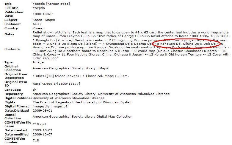
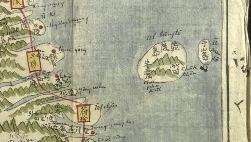
The above map is part of an old Korean map in an atlas entitled "Yeojido" (輿地圖), which is part of the Korean Map Collection at the University of Wisconsin at Milwaukee. The map, which is believed to have been made between 1800 and 1887, shows the Korean island of "Ul-lungto" (菀陵島) and a neighboring island labeled "U San do" (于山島). The description of the map, however, lists the islands as "Ullung Do" and "Dok do," even though Dokdo (Liancourt Rocks) does not appear on the map. Notice that the description of the map was "created" on October 7, 2009.
Usando (于山島 - 우산도) was the old Korean name for Ulleungdo's neighboring island of Jukdo (竹島 - 죽도), which is Ulleungdo's largest neighboring island and only about two kilometers off Ulleungdo's east shore. Koreans, however, claim that Usando was the old Korean name for Liancourt Rocks (Dokdo / Takeshima), but have no maps or documents to back up the claim. Liancourt Rocks is essentially two rock islets, not one, about ninety kilometers southeast of Ulleungdo. Korea's old maps and documents show that Usando was Ulleungdo's neighboring island of Jukdo, not Liancourt Rocks (Dokdo / Takeshima).
It is extremely disappointing to see that the people at the University of Wisconsin at Milwaukee have allowed "Dokdo" advocates to misrepresent the Korean map on the University's Web site. I hope the university quickly corrects the error and is more diligent in the future in guarding against the antics of Korea's "Dokdo" advocates.
Just for your information,
ReplyDeleteKoreans read 竹島 as Jukdo and Japanese read it as Takeshima. So Jukdo and Takeshima are the same thing. It's sooooooo weird that you're saying
'Korea's old maps and documents show that Usando was Ulleungdo's neighboring island of Jukdo, not Liancourt Rocks (Dokdo / Takeshima).'
and say that Dokdo is not a part of Korea.
don't post anything like this if you're not a Korean or japanese and know nothing about the issue- not even the correct terms that ppl name them!!! all you're doing is having ppl have false beliefs on dokdo.
"Univ. of Wisconsin at Milwaukee Duped by "Dokdo" Advocates"???
ReplyDeleteStop name calling people and countries
obviously, you're extremely biased and what's the point of you posting this kind of nonsense?
and till now, we can still see Ul Leung do from dokdo and Dokdo form ul Leung do on sunny days.
That's probably why the ppl of that time thought that Dokdo's only 2km away from ul Leung do.
They didn't have proper rulers and they didn't use the metric system at that time! What do you expect?
Usando (于山島 - 우산도) was the old Korean name for Ulleungdo's neighboring island of Jukdo (竹島 - 죽도), which is Ulleungdo's largest neighboring island and only about two kilometers off Ulleungdo's east shore. Koreans, however, claim that Usando was the old Korean name for Liancourt Rocks (Dokdo / Takeshima), but have no maps or documents to back up the claim.
ReplyDelete~~~~~~~ if you say so, then what IS the island that Koreans called Usando? Were they imagining an island or something? There is ABSOLUTELY NO islands AT ALL between Ul Leung do and Dokdo. GOSH
check the map first before you even talk about this issue!
Jaewon wrote:
ReplyDeleteThere is ABSOLUTELY NO islands AT ALL between Ul Leung do and Dokdo. GOSH, check the map first before you even talk about this issue!
You are very, very wrong. There is an island between the main island of Ulleungdo and "Dokdo." It is Ulleungdo's neighboring island of Jukdo (竹島), which is only two kilometers off Ulleungdo's east shore. You can see it on Google's satellite phote of Ulleungdo HERE.
Notice also that the shape of the island labeled at "Usan" (于山) on the old Korean maps in the above link was very similar in shape to Ulleungdo's neighboring island of Jukdo on Google's satellite photo.
Also, notice that the 1834 Korean map of Ulleungdo had gridlines around its edges. Each gridline represented distances of 10 ri, which was equivalent to 4 kilometers. That means that the 1834 Korean map showed Usando to be about 4 kilometers off Ulleungdo's east shore. Jukdo is about 2 kilometers off Ulleungdo's east shore and Dokdo is about 90 kilometers off Ulleungdo's southeast shore. The distances are compared HERE.
Finally, Dokdo (Liancourt Rocks) is essential two islands, but Korea's old maps of Usando showed it to be one island, not two.
Maybe, the reason you and many other Koreans are ignorant of Ulleungdo's neighboring island of Jukdo is that DAUM, Korea's most popular portal site, has omitted Jukdo from its satellite photo of Ulleungdo. See HERE.
Hi, JaeWon
ReplyDeleteI guess you are Korean, right?
"and till now, we can still see Ul Leung do from dokdo and Dokdo form ul Leung do on sunny days."
Are you perfectly sure about it? Do you know how many days you can see Dokdo from Ulleungdo? On what condition? What about altitude? If you can't prove what you said scientifically, nobody would believe you.
" what IS the island that Koreans called Usando? Were they imagining an island or something? "
Before 1694, the year 張漢相 inspected Ulleungdo and left report, it was basically Ulleungdo's another name. The people of Joseon era got to know there are two islands inhabitable (Ulleungdo and Usando not today's Japanese Takeshima/Dokdo since it's uninhabitable), thouth they were not sure if there is really only one island or two since Ulleungdo was prohibited to voyage to. That was the reason Usando(Korean Jukdo, not Japanese Takeshima) placed west to Ulleungdo before the end of 17C, and sometimes flying around Ulleungdo on the map.. So yes, it was kind of imagining island or something for Korean until 1694. Jang the inspector identified it was Jukdo, the inhabitable island with bamboo fields just 2km off the east coast of Ulleungdo. 1711 Korea's official map of Ulleungdo clearly depicted Jukdo as Usando and most of Korean academics, namely professor Li Sang-tae of Seoul National University, Oh Song-hak of Jeju Uni, the head of Dokdo Museum and even famous historian 宋炳基, already admitted that Usando in the map was Jukdo, not today's Dokdo.
" There is ABSOLUTELY NO islands AT ALL between Ul Leung do and Dokdo. GOSH"
Are you sure? Do you even know where Jukdo is? Which island, Jukdo or Takeshima, is bigger? What about the shape of the two islands? Which is more similar to Usando?
Oh, by the way, do you understand the Chinese? If you do, please translate the sentence below for me. The author was inspecting Ulleungdo at the time.
"北有于山島周回爲二三里許南至都庄仇味"
If you don't please read this post.
1807 May 12 - Lee Tae-gun (李泰根) Inspects Ulleungdo
I honestly hope young Koreans like you are going to study more about at least the geography of Ulleungdo, Jukdo and Takeshima/Liancourt Rocks/Dokdo.
Hi, my name is Angie Cope and I am a librarian at the American Geographical Society Library at the University of Wisconsin Milwaukee. I am the librarian trying to provide access to Korean materials at my library. I do not speak or read Korean or Chinese and have relied heavily on the KINDNESS of others. In the future, should you feel there is an error in my work, please feel free to email me at my work address: acope@uwm.edu.
ReplyDeleteDear Ms. Cope,
ReplyDeleteThank you for taking the time to comment on this blog.
First, let me say that I think your "Digital Map Collection" Web site is beautiful and well organized and makes great use of Web technology to present the wonderful maps in your collection.
Second, I think it is great that people are helping you with the Korean and Chinese on the Korean maps, but, unfortunately, someone seems to have taken advantage of your inability to speak and read Chinese to include Korean "Dokdo" propaganda into the description of the Yeojido map.
The small island off the east shore of Ulleungdo in the Yeojido atlas is clearly labeled as "Usando," not as "Dokdo." There is even an English transliteration of the name beside the island as proof.
To correct the error, you would simply need to change the name from "Dokdo" to "Usando" in your description of the Yeojido map. By using the actually name of the island on the map, you would be able to avoid taking sides on a passionate territorial dispute between Korea and Japan. If you wanted to, you could mention that Korean and Japanese historians disagree on the location of Usando.
Now that you know of the error, I hope it will be corrected soon because if left uncorrected, it not only appear as though your university were taking sides in a territorial dispute between Korea and Japan, the description would be wrong.
Usando was Ulleungdo's neighboring island of "Jukdo," not Dokdo. If you do not want to take sides in the dispute, then simply list the island as "Usando," instead of "Dokdo." That should appear fair to both Korea and Japan.
Again, thank you for showing concern.
Kaneganese, recently a study was undertaken to answer the exact question you put forward.
ReplyDeleteDokdo Island is visible from Ulleungdo East side an average of 3 days per month on clear days. What does this mean? Well, knowing Korean's resided on Ulleungdo since at least the year 512 there were literally tens of thousands of viewing days for these Koreans to have seen Dokdo. From this, it is ludicrous to state ancients Koreans weren't cognizant of Dokdo and didn't voyage there.
The identity of Usando depends on which records you cite.
Using ancient Chosun maps to make claims the broad claim Usando is Jukdo Islet is poor historical study for many reasons.
First, Chosun maps are not true to scale or distance they are very crude geographic representations of Ulleungdo Island.
Second, almost all of these maps are copies of predecessors not based on surveys.
Third the vast majority of Chosun Ulleungdo maps show islands that don't exist to the South of Ulleungdo Island.
Kaneganese, you posted the line from the 1807 inspection. This record states Usando was on Ulleungdo's North side. You forgot to mention that. This would be evidence against Usando being Jukdo Island as you have stated.
Outside of crude Chosun maps we have documents that give us more clear information regarding the identity of Usando. The following facts lead us in a totally different direction that the Japanese lobbyists on this forum would have you believe.
Usando was called Matsushima by the Japanese. This would be Dokdo of course.
Usando was a days sailing from Ulleungdo. This is the travel time to Dokdo as described in other documents and much too long to be Jukdo Island which is only 2kms away.
Dokdo island was desribed as being over 50ri away from Ulleungdo and en route to Japan's Oki Islands. Jukdo Island is not even 1ri away from Ulleungdo.
There are documents which lead us to different directions about the identity of Usando. You will not find the records that support Korea's side of the story here because plain and simple this website is a lobby forum for Japan's Takeshima movement.
Mrs. Cope, do yourself a big favor and think twice before citing any data from this forum that churns out the rhetoric of Shimane Prefecture and Japan's MOFA lobby machine.
By the way Mr Bavers, didn't you once refer to Korean historians as ass-kissing chicken shit?
Ms. Cope,
ReplyDeleteSteve Barber is wrong on many points, and has a history of posting very questionable Dokdo claims on several different Web sites using various annonymous IDs. He only started using his real name after an email of his was discovered on an anti-Japanese Web site under the name "Killzap.cafe." You can read about it HERE.
Welcome to the world of Dokdo/Takeshima debate. This is the very reason I was advising you and your university to remain neutral.
Mr Bevers read your own post you linked to. Can you not read the recipient of my e-mail??
ReplyDeleteThe e-mail you are referring to was sent from me to Mr Cho his e-mail is spar@paran.com.
This is his blog that you label as "수박 겉핥기"
http://blog.naver.com/cms1530
This is the same Mr Cho that you link to on your own blogroll on the lower right of your homepage. The e-mail was forwarded from somebody else to Hanmaumy who ran the Dokdo Guardian historical page and it ended up in cyberspace. Does this mean you are linked to killjap cafe too?
On the subject again
Here are some historical records that state Usando was what Japanese called Matsushima (Dokdo)
http://www.dokdo-takeshima.com/An-yeong-bok-3.jpg
http://www.dokdo-takeshima.com/Usando-songdo-doc.jpg
http://www.dokdo-takeshima.com/1780-korean-usando-doc.jpg
Here is the record stating Usando was 50 ri from Ulleungdo. Much too far away to be Jukdo Islet.
http://www.dokdo-takeshima.com/dokdo-anyongbok-2.html
Mr Bevers, if you are indeed unbiased you need to change your descriptions of the maps on the right side of your page Gerry. As long as the aforementioned records above show Usando could not be Jukdo, then you shouldn't be making such strong assertions about the identity of Usando Island Gerry. Otherwise you are no better than the Koreans you criticize.
So please Gerry Bevers, I've given you data above that show Usando was not Jukdo. You should change your data on this website to avoid taking sides in a very passionate issue!
I find it quite amusing that the owner and operator of a website who translates and posts the propaganda of Shimane Prefecture and Japan's MOFA's lobby machine accuses others of being biased...
Gerry I'm not anonymous at all. Haven't you read about me in the papers?
http://www.dokdo-takeshima.com/korea-herald-front-pg-5.jpg
By the way, if anonymity bothers you so much, why don't you tell me a little about Kaneganese and Pacifist? They have been posting their lies on this and other forums under anonymous handles for years now. Please do tell!!
Steve,
ReplyDeleteAn Yong-bok testified that "Usando was northeast of Ulleungdo, not southeast. See HERE.
The problem is that we cannot be sure where An's "Usando" was because there were a number of inconsistencies with his testimony. Also, we know that he was a liar because he had claimed to be some kind of Ulleungdo tax officer. The Koreans did not even believe him.
However, the most important thing is that after sending an inspector to Ulleungdo to investigate An's claims, Korea's inspectors determined that Usando was Ulleungdo's neighboring island of Jukdo.
In 1694, Korean inspector Jang Han-sang reported that Ulleungdo had a neighboring island two kilometers off its east shore with one side covered in haejang bamboo. In 1711, Inspector Bak Chang-seok draw a map showing Ulleungdo with a neighboring island labeled as having haejang bamboo. He also labeled it as being "the so-called Usando." Then for the next 200 years, Korea's maps of Ulleungdo showed Usando to be Ulleungdo's neighboring island of Jukdo, as the maps show on the right side of my blog.
The island on the 1711 map could not have been Liancourt Rocks (Dokdo/Takeshima) not only because of its location and the fact that it was one island, not two, but also because Liancourt Rocks did not have the soil to grow bamboo. Liancourt Rocks were only barren rocks. See HERE
We have argued all of this before, so it is a waste of time to keep arguing the same points over and over with you.
Korea has no old maps or Liancourt Rocks or any evidence that Koreans ever traveled there before Japanese fishermen started taking them there in the early 1900s. There are only a couple of references in Korean history of an an unnamed island being visible to the east of Ulleungdo, but those references suggested that the island was Japanese.
The Japanese had traveled to Liancourt Rocks since the 1600s and have maps and documents to prove it, but Korean has none, which is why you and Koreans must twist the truth and make unsuppported claims.
You are a white-foreign pawn of Korea with a Web site full of half-truths and falsehoods. That is why you were written up in Korean newspapers, not because you have contributed anything of significance to the debate. You have even admitted that you are dependent on your Korean wife for translations.
Your wife translates Korean documents, and then you twist the meaning and put it up on your Web site. That is nothing to be proud of, Steve. Anyone with any knowledge of the facts and half a mind can glance at your Web site and see that it is nothing but lies, half-truths, and exaggeration.
The difference between you and people like Pacifist and Kaneganese is that they do not post under multiply IDs. Why did you use multiply IDs to post about Dokdo? Why did you spam so many Web sites? Why did you stop using multiply IDs only after you were exposed.
You were one of those people who got pleasure using multiply IDs to spam Web sites with crazy claims. The only reason you came out from under your rock was because we turned the rock over.
Mr Bevers, you selected the one piece of data that suits you lobbyist agenda and threw out the baby with the bathwater on the rest.
ReplyDeleteAnyongbok may have stated Usando was Northeast. It's not at all unreasonable that he saw Dokdo to the East of Ulleungdo and wasn't sure if it was Northeast or Southeast especially if the weather had been murky as which is frequently the case on Ulleungdo.
However, it's not at all plausible that he considered Jukdo Islet to be a day's travel. Jukdo is only 2.kms away, you could literally swim there in under an hour. Dokdo Island is described in historical documents as a day's travel. This is a fact.
Anyongbok plainly said "Usando was what Japanese called Matsushima" How do you suppose he pulled that same name out of his hat Mr Bevers? Matsushima is the Japanese name for Dokdo, that is a fact.
Anyongbok wrote a document stating Takeshima (Ulleungdo) and Matsushima (Dokdo) were part of Korea's Gangwando Province. The Japanese received this document and raised no objection this is a historical fact.
You can see the record here.
Dokdo-Korean
Mr Bevers you can base your slanted theories on inconsistencies, doubts and assumptions but I work from facts.
Yes we have analysed the maps you are talking about before. What the 1711 map drawn by Inspector Bak Seok Chang shows is are the territorial perceptions of one man. He also did not write Usando on the map of Ulleungdo, he wrote "So-Called-Usando" meaning this was his best assumption after Chosun's vacant island policy.
The geographical errors on this map most notably with the position of this "So-called Usando" island leads to the conclusion Inspector Bak did not base his map entirely on a survey but also on the Ulleungdo Sajeok written before. Also drawn are large non-existent islands to the South.
None of the Korean documents you cite are proof of Japanese title Mr Bevers. In fact quite the opposite is true. Both records show the islands were outside of the Japanese territory and within Korea's sphere of influence. I've debunked your slanted translations before.
Regarding translations. My wife doesn't translate traditional Korean or Japanese records. She takes translations by others I've paid to have translated or cited from publications and writes them in English. Judging by the numerous errors you have made maybe you should consult her. Look at your last post Gerry, again you have re-translated the Ulleungdo Sajeok for the umpteenth time to suit your slanted agenda. Each version is little more biased than its predecessor.
Mr Bevers, I have a good laugh when you call me a pawn. Look at the content of your website. Half of the data is the rehashed drivel written by Japan's main Takeshima lobbyist Professor Masao Shimojo and Japan's MOFA. The anonymous Japanese right-wing lobbyists on "your" forum translate and regurgitate every turd Japan's MOFA tosses their way and you've got the stones to call me a "pawn"??
Why would I post with multiple I.D's Mr Bevers? Hmmmm good question.
I don't know, why don't you asked your Japanese nutbar friends from Japan's right-wing channel2 who posted my address and personal data from my website's WHOIS all over cyberspace from the anti Korean forum Occidentalism.
Bevers Japanese Thugs
First I don't spam. I debate the issue with radical pro-Japanese lobbyists like yourself. Whatever name I post, my e-mail address is always the same. No mystery at all.
Why are you afraid to expose the identities of your friends on this forum Gerry? Probably because unlike you, they are ashamed of the falsehoods they have posted here.
↑
ReplyDelete本人がネット上で自分の個人情報だと認めるなんて、珍しいですね。リンク先ブログの持ち主がGerryの友人だといっているのか、それとも私かpacifistさんがこのブログの持ち主だといっているのか、どちらでしょう。どちらもありえないし、しかも2ちゃんねるか何かでこれをさらしたのも私たちでは有り得ない(自慢じゃないけれどやり方がわかりません。)ので、これはひどい中傷ですね。(それはそうと今頃気がついたのでしょうか? 随分のんびりしていますね。)
いずれにせよ彼が短絡的で何の確証もないのに自分の都合のいい妄想について断定的な言論を繰り返す、どうしようもない嘘つきだと言う事がこれではっきりしました。この発言は永久保存です。この人物はこのコメントで自ら認めている通り、マルチIDで適当な事ばかり言ってしかもころころ意見を変え、さらに都合が悪くなると言ってない振りをして白を切るので、もう相手にしないことにしています。時間の無駄ですから。