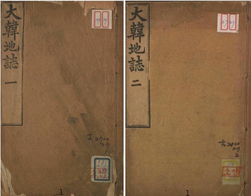
The Daehan Jiji (大韓地誌 -대한지지) was a 2-volume set of Korean elementary school geography books written by Hyeon Chae (玄采 - 현채) that were published in 1899 and republished in 1906. The picture on the left shows the covers for a 1906 version.
The forward was written by Lee Gyu-hwan (李圭桓), who was in charge of the Editorial Department in the Korean Ministry of Education in 1899. In both the forward, and the postscript, written by Hyeon Chae (玄采), it said the author used Japanese geography texts and Korea's Dongguk Yeoji Seungram (東國輿地勝覽 - 동국여지승람) as references.
All together there are fourteen sections in the 2-volume set. The first section is a general introduction that includes information on the location and size of Korea. The remaining thirteen sections deal with Korea's thirteen provinces, and there is a map of each province at the beginning of each section. There was also supposed to be a full map of Korea at the front of the book published by Korea's Ministry of Education, but I did not find the map in the 1906 version found online at the Korean National Library Web site.
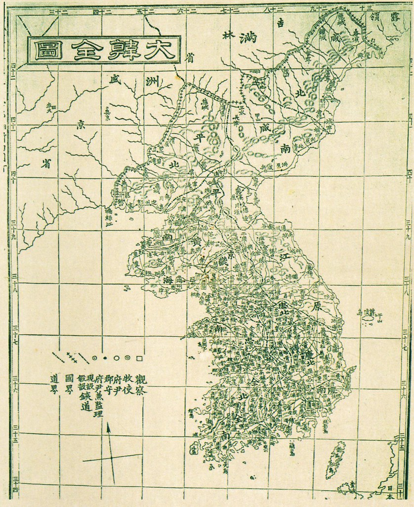 The map to the right is supposed to be the "Daehan Jeondo" (大韓全圖 - 대한전도) from the 1899 version of the Daehan Jiji.
The 1906 version of the Daehan Jiji seems to have been just a reprint of the 1899 version without any updates. For example, Ulleungdo was not shown as a county in either version, even though the island was made a county of Gangwon Province in 1900.
The book is important in the Dokdo-Takeshima debate partly because the coordinates given for Korea in the introduction excluded Liancourt Rocks (Dokdo), but it is mainly important because the map for Gangwon Province shows Ulleungdo with a neighboring island labeled as "Usan" (于山 - 우산).
Koreans claim that Usando (于山島 - 우산도) was the old name for Dokdo (Liancourt Rocks), but the shape and position of the Usan island on this map shows that it was almost certainly Ulleungdo's neighboring island of Jukdo (竹島 - 죽도), which is only about two kilometers off Ulleungdo's east shore. The full map of Korea also showed Usan (于山 - 우산) as Ulleungdo's neighboring island of Jukdo, which is especially important since that map was made by Korea's Ministry of Education.
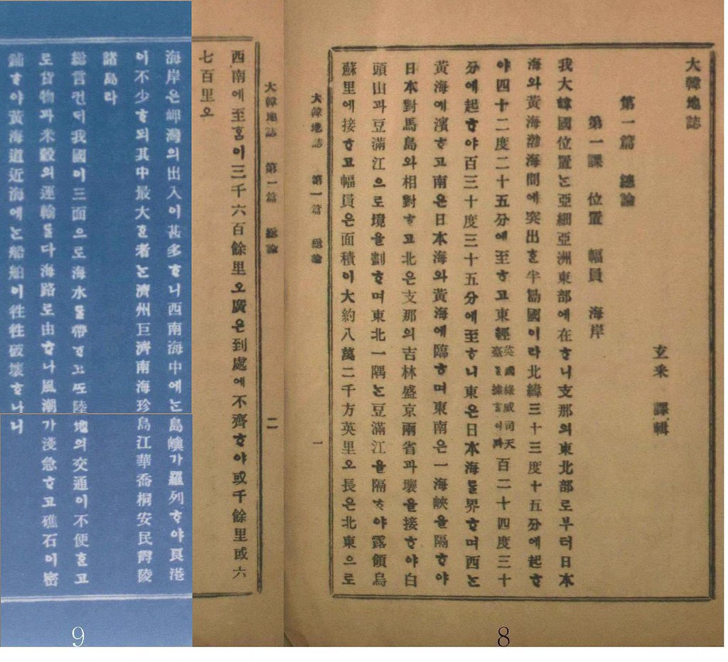
The following is my translation of the section of the book giving Korea's position and area, including its longitudes and latitudes.
Section 1: Introduction
Chapter 1: Location, Width, & Coastline
Our Daehan state is located on the eastern part of the Asian continent. We are a peninsula state that protrudes out from the northeastern portion of China between the Sea of Japan and the Yellow and Bal Seas (黃海 渤海). Our northern latitude begins at 33 degrees 35 minutes and reaches to 42 degrees 25 minutes. Our eastern longitude (based on the Greenwich Observatory in England) begins at 124 degrees 30 minutes and reaches to 130 degrees 35 minutes.
The east borders the Sea of Japan; the west borders the Yellow Sea; and the south borders the Sea of Japan and the Yellow Sea. The southeast faces Japan’s Daemado [Tsushima] with one strait in between. The north borders the area of the two Chinese provinces of Jilin and Shengjing (支那의 吉林盛京兩省). The border is drawn by Mount Baekdu and the Duman River. One corner between the Duman River in the northeast borders the Russian territory of “Josori” (鳥蘇里).
The area [of the country] is essentially 82,000 square English miles. The length from the northeast to the southwest is about 3,600 ri. The width is irregular in several places. Sometimes it is about 1,000 ri, and sometimes it is 600 or 700 ri.
-----------------
第一篇 總論
第一課 位置 幅員
我大韓國位置는 亞細亞洲東部에 在하니 支那의 東北部로부터 日本海와 黃海 渤海 間에 突出한 半島國이라 北緯三十三度十五分에 起하야 四十二度二十五分에 至하고 東經 (英國錄威司天臺를 據함이 타) 百二十四度 三十分에 起하야 百三十度三十五分에 至하니 東은 日本海를 界하며 西는 黃海에 濱하고 南은 日本海와 黃海에 臨하며 東南은 一海峽을 隔하야 日本對馬島와 相對하고 北은 支那의 吉林盛京兩省과 壤을 接하야 白頭山과 豆滿江으로 境을 劃하며 東北一隅는 豆滿江을 隔하야 露領 鳥蘇里에 接하묘 幅員은 面積이 大約八萬二千方英里오 長은 北東으로 西南에 至함이 三千六百餘里오 廣은 到處에 不齊하야 或 千餘里 或六七百里오
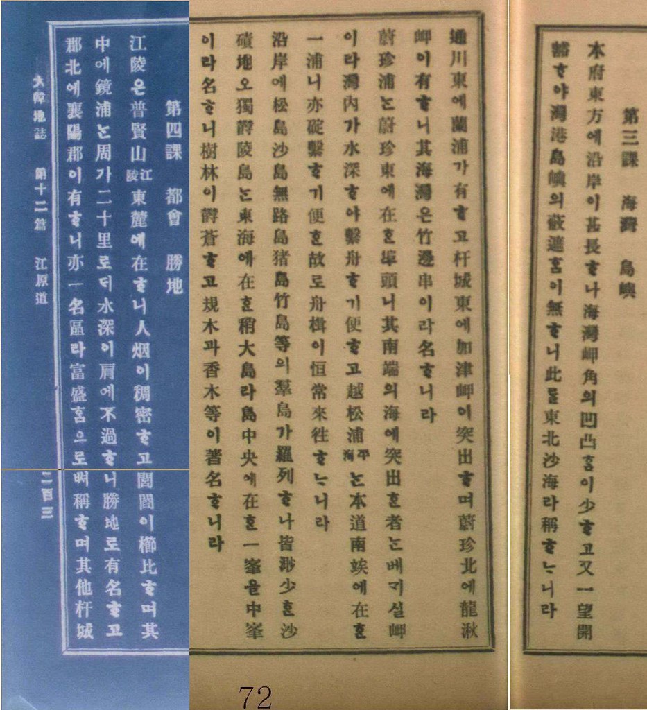
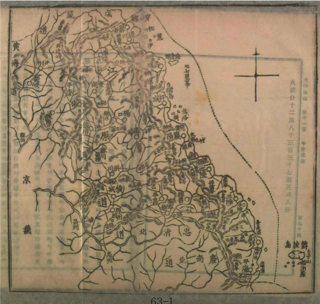
The following is from the chapter on "Bays and Islands" from the Gangwon Province section of the book.
Chapter 3: Bays & Islands
East of this district, the coastline is quite long, but irregularities in the bays and capes are few. With one glance, one can see that it is wide open with no bays or islands blocking the view, so it is called the northeast desert sea (東北沙海).
East of Dongcheon (通川) is Nanpo (蘭浦). East of Ganseong (杆城) is Cape Gajin (加津岬). North of Uljin (蔚珍) is Cape Yongchu (龍湫岬). That bay is called Cape Jukbyeon (竹邊串).
Uljin-po (蔚珍浦) is a wharf east of Uljin. The southern tip that protrudes out into the sea is Cape “Begaesil” (베개실岬). The water is deep inside the bay, making it convenient to anchor boats. Weolsong-po [越松浦 (Pyeonghae - 平海)] is a port at the southern end [南竢 should be 南端?] of this province where it is also convenient to anchor, making it a place where ships regularly come and go.
Songdo (松島), Sado (沙島), Murodo (無路島), Jeodo (猪島), and Jukdo (竹島) are part of a group of islands that line the coast, but they are all small sand or gravel islets. Ulleungdo (獨鬱陵島) is the only fairly large island in the East Sea. In the center of the island is a peak called “Jungbong” (中峯). Its forrest is lush with such sought-after trees as zelkova (規木) and juniper (香木).
---------------
第三課: 海灣, 島嶼
本府東方에 沿岸이 深長하나 海灣岬角의 凹凸함이 少하고 又一望 開豁하야 海灣島嶼의 蔽遮함이 無하니 此를 東北沙海라 稱하느니라.
通川東에 蘭浦가 유하고 杆城東에 加津岬이 突出하며 蔚珍 北에 龍湫岬이 有하니 其海灣은 竹邊串이라 名하니라.
蔚珍浦는 蔚珍東에 在한 埠頭니 其南端의 海에 突出한 者는 베개실岬이라 灣內가 水深하야 繋舟하기 便하고 越松浦 (平海)는 本道 南竢에 在한 一浦니 亦 碇 *하기 便한 故로 舟楫이 恒常 來往하느리라.
沿岸에 松島 沙島 無路島 猪島 竹島 等의 羣島가 羅列하나 皆 渺小한 沙磧地오. 獨鬱陵島는 東海에 在한 稍大島라 島中央에 在한 一峯을 中峯이라 名하니 樹林이 鬱蒼하고 規木과 香木 等이 著名하니라.
The following is the map of Gangwon Province from the 1906 book.


Other Korean Geography Books:
Could someone please check to make sure I got all the Chinese characters correct. There is one character I could not recognize and, at least, two more I am unsure of. They are all in the chapter on "Bays and Islands." I marked the character I did not recognized with a red asterisk and the two characters I am unsure of in red, as well.
ReplyDeleteI would like to confirm those three characters before I translate that section of the text.
本府東方에 沿岸이 深長하나 海灣岬角의 凹凸함이 少하고 又一望 開豁하야 海灣島嶼의 蔽遮함이 無하니 此를 東北沙海라 稱하느니라.
ReplyDelete↓
本府東方에 沿岸이 甚長하나 海灣岬角의 凹凸함이 少하고 又一望 開豁하야 灣港島嶼의 蔽遮함이 無하니 此를 東北沙海라 稱하느니라.
「豁」means being open and wide.
「蔽遮」means obstacles.
* 舟=繋舟(To let a ship anchor in the port)
ReplyDelete碇 *=碇繋
沙磧*=沙磧地
Thank you very much, Chaamiey. That's what I needed.
ReplyDeleteMy pleasure,Mr.Bevers,
ReplyDelete그런데,
I think it is suitable to translate "only" about "獨" of "獨鬱陵島".
Because the sentence is emphasizing the characteristics of Ulleungdo in comparison with other rocky islets.
Chaamiey,
ReplyDeleteYes, I see what you mean. I have changed it. Thanks.
Gerry,
ReplyDeleteI think 朝鮮全島 should be 朝鮮全図. (朝鮮全島 means the whole island of Chosun.)
Sorry, correction.
ReplyDeleteIt was 大韓全図, not 朝鮮全図.
Thank you, Pacifist. I have corrected it.
ReplyDelete