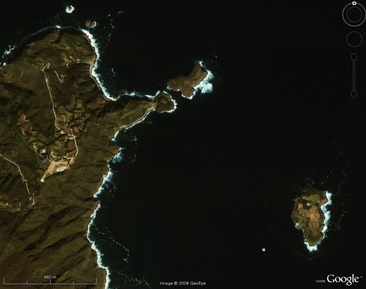
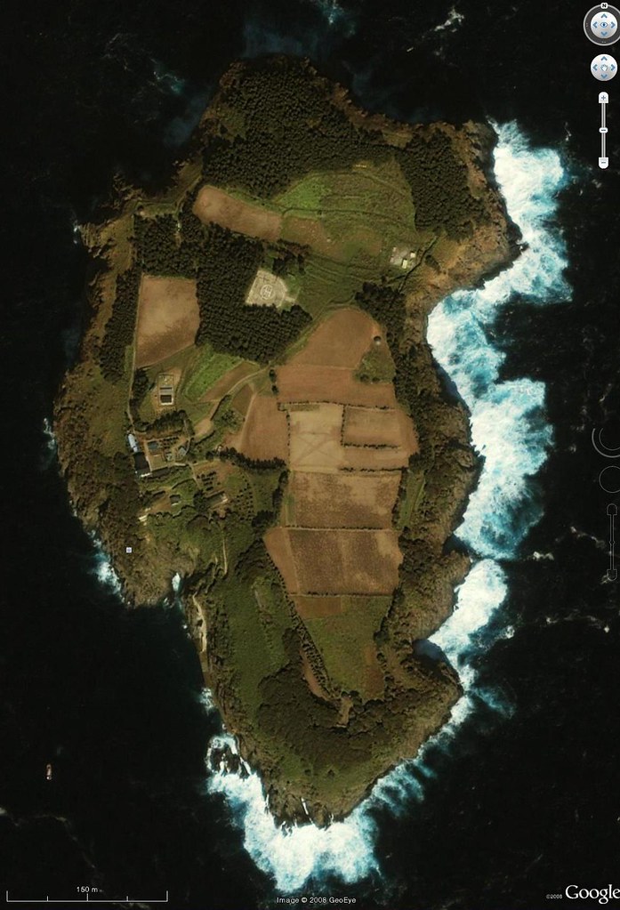
Below is a close-up of Ulleungdo's neighboring island of Jukdo (竹島 - 죽도), which is about fifty-one acres (207,818 sq. meters) of essentially flat, fertile land. Jukdo means "Bamboo Island," and even today the island has a grove of bamboo growing on it. The old Korean name for Jukdo was Usando (于山島 - 우산도), and the island has appeared on Korean maps of Ulleungdo since the 16th century. Usando means "Island of Usan." Though Koreans claim that Usando was the old Korean name for Dokdo (Liancourt Rocks), Korea's old maps show quite clearly that it was actually Ulleungdo's neighboring island of Jukdo.
Below is a map of Ulleungdo (鬱陵島 - 울릉도) from the 1834 Korean atlas "Cheonggu-do" (靑邱圖 - 청구도), which was made by famed Korean mapmaker Kim Jeong-ho (金正浩 - 김정호). The map shows an island offshore labeled as "Usan" (于山) off Ulleungdo's eastern shore. The hash marks at the bottom of the map represented ten ri segments, which was about four kilometers. That means that the map showed "Usan" about four kilometers offshore. From the position of the island and its shape, we know that "Usan" (于山 - 우산) was Ulleungdo's neighboring island of Jukdo (竹島 - 죽도).
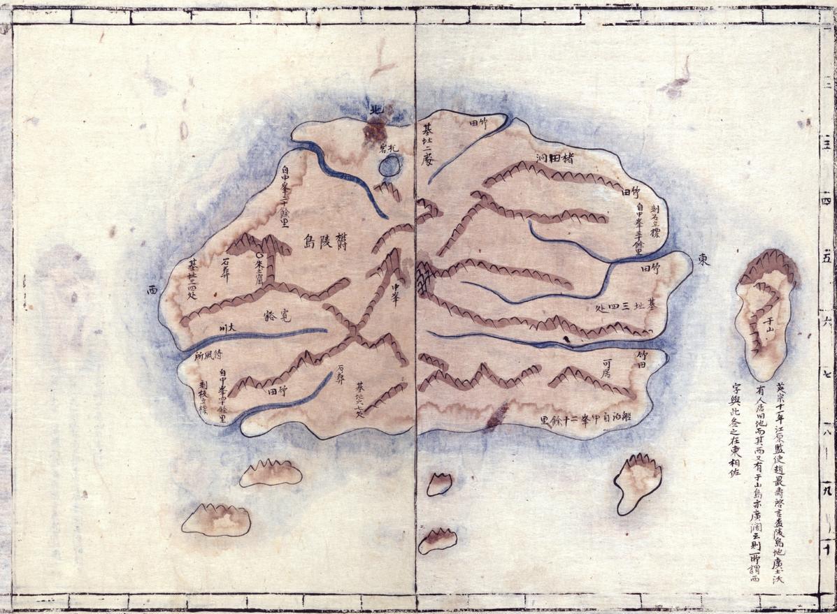
For more than fifty years, South Korea has been trying to justify her armed occupation of the Japanese islets of Takeshima (Liancourt Rocks), which Koreans call Dokdo (獨島 - 독도), by claiming that it was the old Korean island of Usando (于山島 - 우산도), but Korea's own maps and documents prove that claim false. Liancourt Rocks (Dokdo) is essentially two rock islets ninety-two kilometers southeast of Ulleungdo, but Korean maps show that Usando was only one island just off Ulleungdo's east shore.
The picture below shows the satellite photo of Ulleungdo's neighboring island of Jukdo with an overlay of the Usando from the 1834 Korean map. Notice that the shapes are very similar. (The overlay was prepared by commentor GTOMR.)

Great photo!
ReplyDeleteThere are fields!
I plotted Korean antique detail map of Ulluengdo on 1834 into Usando-Jukdo on google earth
ReplyDeleteIt's interesting. They are in similar shape - just like a straw sandal.
ReplyDeleteKorean should be proud of their ancesters who depicted Jukdo (= Usando), a tiny and remote island which located more than 100km from mainland, very accurately almost 150 years ago. And they should stop degrading their own past eographers by claiming Usando is not Jukdo but today's Takeshima/Dokdo and they were not incapable of drawing remote islands accurately. Kim didn't go to Ulleungdo, but did a great job. I think he is a genious.
ReplyDeleteBy the way, it looks like Euglena (ミドリムシ)or ツチノコ to me.
Gerry, the map you posted is simply a map of Pak Chang Seok's 1711 map and it has many of the same errors. In fact if you view the entire map and look at the positions of other locations on Ulleungdo it becomes clear this map is a simply a very bad copy of Pak's map.
ReplyDeleteOrigin-of-Chosun-Map-Errors
Can you see that near to this "Usando" is the character 東 or East? This means the mapmaker drew Usando on the southeast part of Ulleungdo.
First look at the location of 洞田著 on your map
Jeodong=洞田著-1
This is today's Jeodong Harbor (저동) which is on Ulleungdo's East side not the northeast.
You can see where Jeodong is on this map.
Jeodong=洞田著-2
Next, look at the characters 刻石立標 slightly to the North of "Usando". These characters mark Dokdo Harbor where Pak Chang Seok left his stone marker on Ulleungdo in 1711. You can see on your map here the same characters.
Dodong=刻石立標-1
Pak's original map showed the same characters. See this map.
Dodong=刻石立標-2
However another glaring error on this map that shows its inaccuracy is how Elephant Rock is drawn actually on Ulleungdo You can see 孔岩 is drawn as a water or rock? on Ulleungdo. See the map in its entire form.
Elephant-Rock=孔岩
The location of the real Elephant Rock (孔岩) can be see on this map.
Elephant-Rock=孔岩-2
When we compare the shape of the other island to the south of "Usando" it differs very little form the island you say is Jukdo. On top of that, there are four huge islands on the South side of Ulleungdo that simply don't exist Gerry.
Gerry, you've taken one attribute of a map that matches your agenda and ignored the glaring errors that prove you are wrong and even allow us to trace the origin of why. The funky flashing red doesn't hide your false assumptions Gerry.
The jig is up on these maps.
Surprise surprise, Usan in the map looks as different rock islets to the eyes of this handsome frog with a beard.
ReplyDeletePacifist, stop being so infantile and admit those on this forum have been terribly wrong in their assessment of old Chosun maps.
ReplyDeleteMost notably was Japanese Professor Fusunagi also simply eyeballed these maps and labelled Ulleungdo under the false premise that "所謂于山島“ was Jukdo Islet.
Here you can see he took Gerry's incorrect assumptions and ran with it.
Shimane-Was-Wrong
Yes, Pacifist I am a Canadian expat who had a beard. Exactly who are you, and why should anyone give a crap about the opinions of some anonymous Japanese right wing lobbyists?
I'm not a right wing lobbyist, I'm just an ordinary citizen.
ReplyDeleteOrdinary Japanese people know what Rhee Syngman did in the 1950's, although Korean people were not informed.
How does the island titled "Usan" in the map look like? The decision must be left to the readers, do not repeat the old Rhee Syngman propaganda again.
I guess ordinaly Korean imagine Japanese right wing like this violent and illegal group?
ReplyDeleteBut those are actually not Japanese. see name list in the same link above.
It is nothing to do with Left-wing or Right wing when talking about Takeshima territorial disputes.
And even extreme left of Communist party, and mid-lett of Komei-party claims that Korean's illegal occupation.
But the peopel who have strange relation and connection with North/South Korea claims different.
Just a simple question, please...? Dokdo doesn't look very hospitible for much more than low ground plants...grass and wildflowers and such.
ReplyDeleteWhy would anybody name it "bamboo Island"? That is, if anybody ever did. I know that seems a silly question, but I've never seen it addressed in the discussions relating to the Dokdo/Takeshima dispute. I've seen lots of discussion arguing about the old Korean maps, but little mention of the old Japanese maps, including the possibility that what THEY called "Bamboo Island" (Takeshima) might, in fact, be one of the islands to their west that had.......BAMBOO(!!) on it...such as Jukdo, perhaps. Gee, what a novel idea: Naming an island Bamboo island because it has banboo on it. Is there any historical evidence that Dokdo ever had any significant amount of bamboo on it? I'm not taking a position here, just asking what I think might be a relevant question that I haven't seen addressed yet.
See here,please,
ReplyDeletehttp://store.shopping.yahoo.co.jp/bonita-bonita/enlargedimage.html?code=kadomatu2007&img=//a248.e.akamai.net/f/248/37952/1h/image.shopping.yahoo.co.jp/i/l/bonita-bonita_kadomatu2007
It's KADOMATSU, which is New Year's decorations in Japan.
It is made of pine,bamboo and plum.
pine=matsu
bamboo=take
plum=ume
Those three kinds of plants are the symbol of long life and energy for life. So,Japanese like the word "matsu" or "take".
Japanese once called Ulleungdo as "Take-Island" because Ulleungdo has much bamboo,and called Liancourt Rocks as "Matsu-island" though there is no pine trees.
And then,"Take-Island" and "Matsu-island" were replaced with each other because of the trouble of map-making by Europe.
So,we call the island as TAKESHIMA now.
Sorry,I should say ,
ReplyDeleteAnd then,the names of "Take-Island" and "Matsu-island" were replaced with each other because of the trouble of map-making by Europe.
Harlie
ReplyDeleteThank you for your comment. We did talked about this before, but I don't remenber where it was.
If you know Japanese culture, it is no surprise to call barren islets as 竹島(Bamboo Island) or 松島(Pine Island) at all. Takeshima had been long called as "Matsushima(Pine Island)", though there were no pine tree on the island, for almost 300 years until the end of Edo. Nobody argues this even Korean. As chaamiey already explained it to you, it only means "lucky island" or something like that. "松""竹""梅" are sitll used everywhere in modern life in Japan, as the symbol for prosperity, long life, health or happy events. It's came from Chinese saying "歳寒三友" which originate from "論語(the Analects of Confucius)"
"(子曰)、歳寒、然後知松柏之後凋也"("論語" 子罕第九)
It means this tiny island were very precious for Japanese in Edo era. The fishermen from Yonago exceptionally allowed to travel and catch avalones by Shogunate in 1600s. It was priviledge for them. Even Tottori Clan had no authority on the island.
Korean started to write it as "独島", which means "Lonely Island" or "Sole Island", in 1904 when they were hired by Japanese fishermen. This is a concrete evidence itself that Korean back then didn't consider it as a neighbouring island of Ulleungdo at all, while Korean government insisit that Dokdo had been the part of Ulleungdo since 512 A.D. What a joke.
harlie,
ReplyDeleteAs chaamiey and Kaneganese already explained, the name of Takeshima or Matsushima doesn't have grave meaning.
When they named Ulleungdo as Takeshima (or Isotakeshima) in the olden time, it was simply because the island was full of bamboo.
Then, when they needed a name at the rocks between Oki islands and Ulleungdo, it was naturally named as Matsushima (Pine island) as an association because Take (bamboo) and Matsu (pine wood) are a kind of a couple of lucky words in Japan (maybe the same in China and Korea).
When European ships discovered islands in the Sea of Japan they mismapped Argonaut island (phantom island of Ulleungdo) which was later thought to be "Take" island of Japan. They named true Ulleungdo as Dagelet island which was later thought to be "Matsu" island of Japan.
But the "Take" island (phantom island) would disappear after they found it was not present.
And afterwards, European ships "discovered" Liancourt Rocks (Hornet Rocks) in the 19th century. The rocks had been called as "Matsu" island in Japan berfore but the name now went to Ulleungdo. So they had to call the rocks as "Yanko" island or "Ryanko" island after the name of Liancourt Rocks.
So when Japanese government decided the incorporation of the rocks in 1905 they re-named the rocks as "Take" island, the name once discarded but a lucky name coupled with "Matsu". I think they should have named as "Ume" island (plum island) instead in order to dodge the turmoil of later years...