See the maps belows:
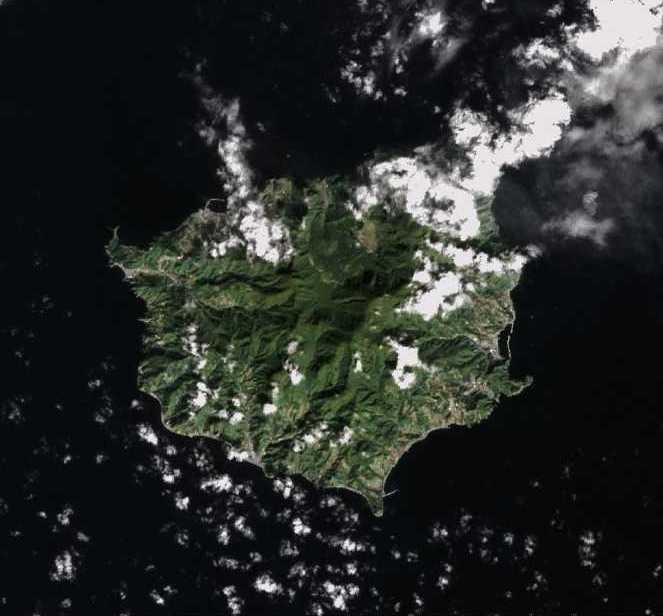
Landsat Photo taken on April 8, 2000

Notice in the above photo that Ulleungdo's neighboring island of Jukdo can be clearly seen off Ulleungdo's east shore. Now compare it with the following Landsat photo of Ulleungdo taken on September 29, 1999.
Landsat - September 29, 1999
Even though it is slight obscured by clould cover in the above photo, Jukdo is still visible off Ulleungdo's east shore. Now compare the above photo with the following photo from Microsoft's Virtual Earth.
Microsoft Virtual Earth
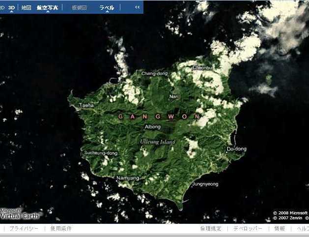
Notice that the cloud pattern in the the Virtual Earth photo above is the same as that in the September 29, 1999 Landsat photo, which tells us that they are the same photos. Notice also that Jukdo can be seen in both photos. Now compare the above photos with the following photo from Google Earth.
Notice that the cloud pattern in the the Virtual Earth photo above is the same as that in the September 29, 1999 Landsat photo, which tells us that they are the same photos. Notice also that Jukdo can be seen in both photos. Now compare the above photos with the following photo from Google Earth.
Google Earth

Even though the cloud pattern in the Google Earth photo appears to be the same as that in the Virtual Earth and the September 29 Landsat photos above, Ulleungdo's neighboring island of Jukdo and the clouds near it are faded out in the Google Earth photo. Why? Could it be that Google does not what people to know that Ulleungdo has a neighboring island? See also HERE.
Now look at a satellite photo of Ulleungdo taken from Korea's Arirang 1 satellite.

Notice in the above photo that Ulleungdo's neighboring island of Jukdo does not appear because it has been chopped off. I do not know who did the chopping, but I wonder why they did it.
Below is a closeup shot of Ulleungdo's neighboring island of Jukdo from Microsoft's Virtual Earth satellite photos. The writing in red was added by me:
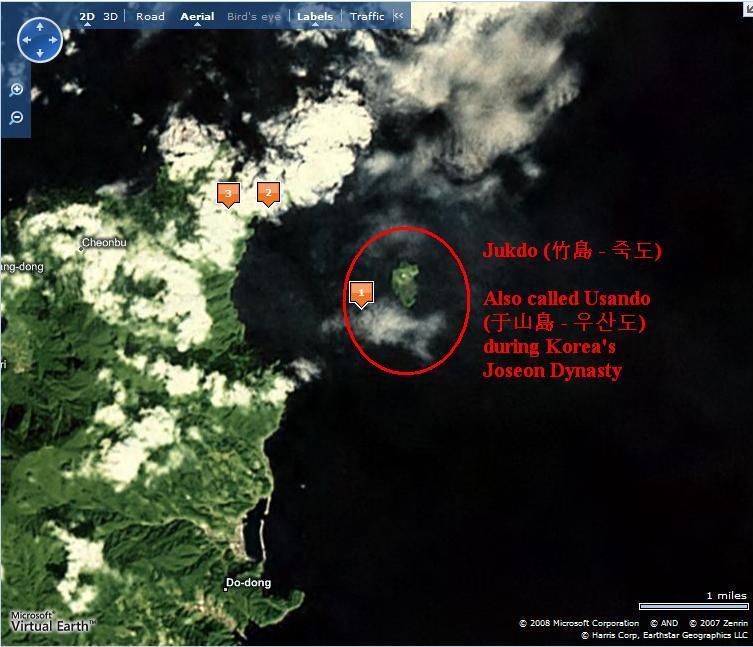
Old Korean and Japanese maps show that Ulleungdo's neighboring island of Jukdo was once called "Usando" (于山島 - 우산도). Even though Koreans claim that the Usando on the old maps was Liancourt Rocks (Dokdo/Takeshima), the fact that it was drawn just offshore Ulleungdo and the fact that it was drawn as one island, not two, tell us that it could not have been Liancourt Rocks. Liancourt Rocks is ninety-two kilometers southeast of Ulleungdo and is essentially made up of two rock islets, not one.
A suspicious person might jump to the conclusion that Ulleungdo's neighboring island of Jukdo was excluded from Google Earth's photo and Korea's Arirang satellite photo because it was feared that people might see the photos and realize that the Usando on old Korean and Japanese maps was actually Ulleungdo's Jukdo. Of course, that would be an unproven suspicion.
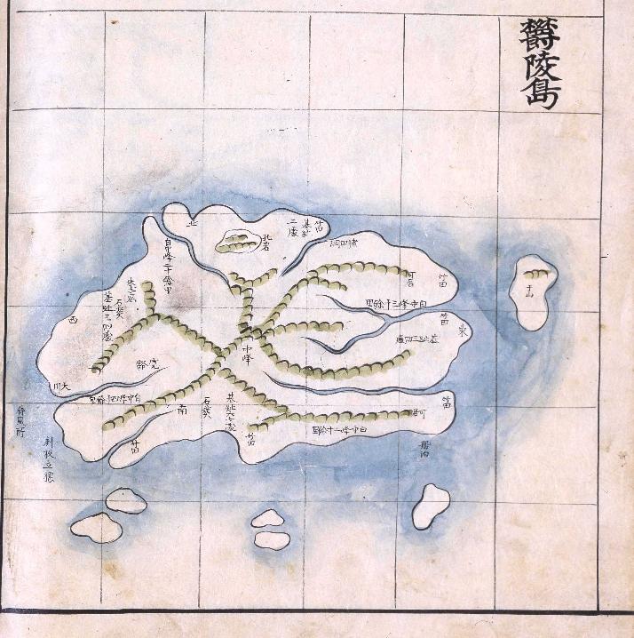
By the way, the following is an old Korean map of Ulleungdo made sometime between 1777 and 1787. Notice that it shows a small island just off Ulleungdo's east shore labeled as 于山, which is pronounced as "Usan" (우산). The map is stored in the National Library of Korea.
Gerry,
ReplyDeleteIs Google Earth under the control of the Korean government?
Pacifist,
ReplyDeleteI heard Panoramio case, one of the sister company of Google earth, the website customer upload their own taken photo and open in the public.
I heard Panoramio don't delete overrule "Dokdo" post by Korean who use copyright violation and copied photo from Internet.
It has also some rumor that there are Korean staff commit the company.
GTOMR,
ReplyDeleteThanks for the comment. So there should be some doubts concerning the vanishment of Jukdo, I see.
Pacifist,
ReplyDeleteNo, I do not think the Korean government has control of Google Earth. I just think it is a little strange that Google Earth does not show Jukdo.
My post is half joking, but also half wondering about the coincidence.
As a Japanese, I believe that "Takeshima" belongs to Japan. On the other hand, if Korean also believe the island as their own country, it's deserve to listen. Because, in any countries, people tend to believe what they want to believe and ignore other countries' opinions. I think it's worng. What is important is to know the truth and do justice according to international law.
ReplyDeleteJapanese government has offered Korea to urgue this issue at International Court of Justice several times. But, Korea never accept the offer. I think that's the problem.
I have doubt toward a Korean insincere manner. Takeshima is a territory of our country decided definitely as a result of careful examination by GHQ after World War II. 42 countries ratify San Francisco treaty, and it is recognized globally. Korea invades it militarily one-sidedly and stays. I am quite barbarian with the use of armed force even if I do not understand decision of GHQ. Furthermore, when we Japan argued about the document which I showed in detail and gave advice to Japan sometimes in the past, Korea fell silence and withdrew it. I have forged a map. There is distrust in a claim changing each time. That you judge it when a Korean is informed of all the documents properly is doubt.
ReplyDelete29.DEC.1949
ReplyDeleteArticle 3 1.The Territory of Japan shall comprise the four principal Japanese islands of Honshu, Kyushu, Shikoku and Hokkaido and all adjacent minor islands, including the islands of the Inland sea(seto Naikai); Tsushima,Takeshima (Liancourt Rocks), Oki retto, Sado, Okujiri, Rebun, Riishiri and all other islands in the Japan Sea (Nippon Kai) within a line connecting the farther shores of Tsushima, Takeshima and Rebun; the Goto archipelago, the Ryukyu Islands north of 29° N. Latitude, and all other islanls of the East China Sea east of longtude 127° east of Greenwich and north of 29°N. Latitude; the Izu Islands southward to end including Sofu Gan (lot's Wife) and all other islands of the Philippine Sea nearer to the four principal islands than the islands named; and the Habomai group and Shikotan lying to the east and south of a line extending from a point in 43°35' N.Lati- tude, 145°35' E. logitude to a point in 44°N. latitude, 146°30' E. longitude, and to the south of a line drawn due east on the parsllel in 44° N. Lati- tude. All of the islands identified above, with a three-mile belt of territorial waters, shall belong to Japan.
19.NOV.1949
ReplyDeletefrom「Detailed Comment on November 2 Draft Treaty」
With regard to the dispositon of islands formerly posessed by Japan in the direction of Korea it is suggested that Liancourt Rocks (Takeshima) be specified in our proposed Article 3 as belonging to Japan. Japan's claim to these islands is old and appears valid, and it is difficult to regard them as islands off the shore of Korea. Security considerations might render the provision of weather and radar station on these islands a matter of interest to the United States.
PLEASE READ "Commentary on Draft Treaty of Peace with Japan"
ReplyDeletein JULY.1950
Correction demand in 1951 of South Korea
South Korea submitted the following opinion books to the U.S.-Britain cooperation draft that contained Takeshima in the area in Japan by the Yang Yuncha the garrison and the U.S. ambassador name on July 19, 1951.
There is details where South Korea is not admitted to insist.
Takeshima was excluded from a Korean territory by the consequential final decision on GHQ in Article 2, and ..substitute.. Ayagema was included. It had Treaty of Peace with Japan in a word and Takeshima was fixed as a Japanese territory.
BUT
다케시마 영유권에 관한 일본의 일관된 입장
ReplyDelete1. 다케시마는 역사적 사실에 입각해 봐도, 국제법상으로도 명백한 일본 고유의 영토입니다.
2. 한국에 의한 다케시마 점거는 국제법상 아무런 근거 없이 이루어지고 있는 불법 점거이며 한국이 이런 불법 점거에 의거하며 다케시마에서 행하는 어떤 조치도 법적인 정당성이 있는 것은 아닙니다.
※ 한국측으로부터 일본이 다케시마를 실효적으로 지배하고 영유권을 확립하기 이전에 한국이 이 섬을 실효적으로 지배하고 있었다는 사실을 보여주는 명확한 근거가 제시되지 않고 있습니다.
Everyone, please look through these pdf files.
ReplyDeleteThese are written from the official viewpoint of Japanese government.
www.mofa.go.jp/region/asia-paci/
takeshima/pamphlet_e.pdf
(English)
www.mofa.go.jp/region/asia-paci/
takeshima/pamphlet_k.pdf
(Korean)
>会議冒頭で発言する韓首相=20日、ソウル(聯合)
ReplyDelete>【ソウル20日聯合】韓昇洙(ハン・スンス)首相は20日、「独島は歴史的、地理的、国際法的にわが固有の地で、あれこれあげつらう理由はない。実効的に支配しており、独島領有権に対しては異論の余地がない」と強調した。
(総理公館で開かれた政府・与党・青瓦台(大統領府)高官会議に首席した韓首相)
-当方の見解-
竹島の領有権において、歴史的、地理的、国際法的に「韓国の固有の地」として認定された事実は、これまでに一度としてない。
①歴史的な事実
1904(明治37)年9月、竹島を「島根県所属隠岐島司ノ所管」とし、領有権を明確にしている。それ以前においては島根県の漁民が竹島でのアシカ漁を代々続けており、これは1941(昭和16)年の第二次世界大戦の日本国参戦まで継続されていた。(世界対戦の期間中に韓国が竹島の存在を認識していた事実はない)
②地理的な事実
世界大戦後の「サンフランシスコ平和条約」にて、日本国からの独立を承認された韓国(当時は朝鮮)は、1952(昭和27)年1月、李承晩韓国大統領が「海洋主権宣言」を行い、「李承晩ライン」として、公海上に違法な線引き(現在の実行支配と似ている。この手の手法が朝鮮・韓国の唯一の外交手段であることが、世界を無秩序化に至らしめている)を行った。この韓国に対して、当時の戦勝国である米国は同年8月、「我々の情報によれば、竹島(独島)は朝鮮の一部として取り扱われたことが決してなく、1905年頃から日本の島根県隠岐島支庁の管轄下にある。この島は、かつて朝鮮によって領有権の主張がなされたとは見られない。」と回答されている。
③国際法的な事実
1952(昭和27)年7月、日米安全保障条約の日米合同委員会において、在日米軍の使用する海上演習及び訓練区域の1つとして竹島が指定されている。この「海上演習及び訓練区域」として竹島を指定した事実は、竹島が「日本国内の施設又は区域」と規定され、扱われていたことの裏づけである。
ちなみに、1954(昭和29)年9月日本国は韓国側に対して、領有権の判断を国際司法裁判所に付託することを提案するが、韓国側はこの提案を拒否し、また、1962(昭和37)年3月の日韓外相会談において再度、日本国より同様の提案をするが、またしても韓国側は回答をせず、今日に至っている。
従って、韓昇洙韓国首相の言を裏付ける事実は何もない。
現在の韓○政府及び一般市民の行動は、世界のルールに違反するものであり、「実行支配」(居座り)の名を借りた「紛争(テロ)・挑発行為」をしているものである。
日本は当時より現在に至るまで一貫して、常に「紳士的」な近隣の友好国として、平和的な姿勢で対応し、武力に寄らない解決策を提案してきている。
以上がこれまでの韓○に対する日本の姿勢及び行動である。
Maybe from today, or last nite, I found on this morning that
ReplyDeleteGoogle Earth converted unclear part north east of Ulluengdo into clear image of Usando-Jukdo and Gwaneumdo
Thank you, GTOMR. I have made a new post about the new satellite photos. They are great.
ReplyDeleteI guess Google was listening. :)