A closeup of the map shows two islands and their neighboring islands off the east coast of Korea. The island nearest the Korean coastline is labeled "Takeshima, also called Ulleungdo" (竹島 一名 鬱陵島). It also has a neighboring just off its west shore labeled as "Ulsando" (亐山島), which was one of the misspellings for "Usando" (于山島). To the southeast of Takeshima is another island labeled as Matsushima (柗島), which was also written as "松島."
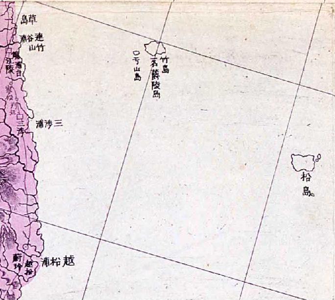
The map is important in the Dokdo-Takeshima debate because it shows Ulsando (亐山島) as a neighboring island of Takeshima (竹島 - Ulleungdo) while also showing a separate island much farther to the southeast labeled as "Matsushima" (柗島). Koreans claim that the Japanese believed that Usando (于山島) was the Japanese island of Matsushima, which was the old Japanese name for Liancourt Rocks; however, this map and others (1875 Japanese Map) are evidence that the Japanese believed Usando to be a neighboring island of Ulleungdo, not Liancourt Rocks.
Actually, the positions of Takeshima and Matsushima on the map are wrong. It appears the mapmaker believed Takeshima (Ulleungdo) to be the non-existent island of Argonaut, which was a mismapping of Ulleungdo by the Bristish ship Argonaut in 1789. Since the Japanese knew the Japanese island of Matsushima (Liancourt Rocks) to be southeast of Ulleungdo, the real Ulleungdo was apparently mislabeled as Matsushima. This can be verified by the shape and postion of the island labeled as Matsushima on the map.
Koreans claim that Usando (于山島) was the old Korean name for Liancourt Rocks, but this map and, in fact, all Korean and Japanese maps, shows that Usando was just a neighboring island of Ulleungdo, not Liancourt Rocks.
Gerry, the mapmaker believed Ulleungdo to be Takeshima to the East. Matsushima to the West was simply Matsushima (Dokdo) with the incorrect form of the real Ullengdo traced that's all.
ReplyDeleteThe author of the map cited very old Chosun maps that showed Usando to the West of Ulleungdo and also cited Japanese maps that for about 150 years prior showed Takeshima and Matsushima (two islands in the East Sea) On top of this the mapmaker used the positonal errors of Seibold and labelled them accordingly. None of these Japanese mapmakers had a clue the Europeans had double mapped Ulleungdo.
The Japanese knew Matsushima (Dokdo) was East of Takeshima (Ulleungdo) The Japanese insist Meiji Era cartrographers knowingly double mapped Ulleungdo and eliminated Dokdo. This is nonsense. This map is a mosaic of errors most of which simply translated into positional mistakes of the islands.
Using inaccurate Japanese maps to define the territorial perceptions of the Koreans is pretty lame Gerry.
Thank you, Gerry
ReplyDeleteHow do you get these maps? It is amazing. I agree that the map depicted Matsushima(Ulleundo) very accurately in its shape and location.
I cheked the location. Takeshima/Liancourt Rocks supposed to be drawn under the squred expamples to the right. See here. . The lines of the map are neither latitude nor longitude, and moreover, geography of Choson peninsula and Japan are disfigured. So I double-cheked not only the lines between Tumen River and Kokura or Hamada, but also each longitude and latitude lines verified from the names of the cities and location.
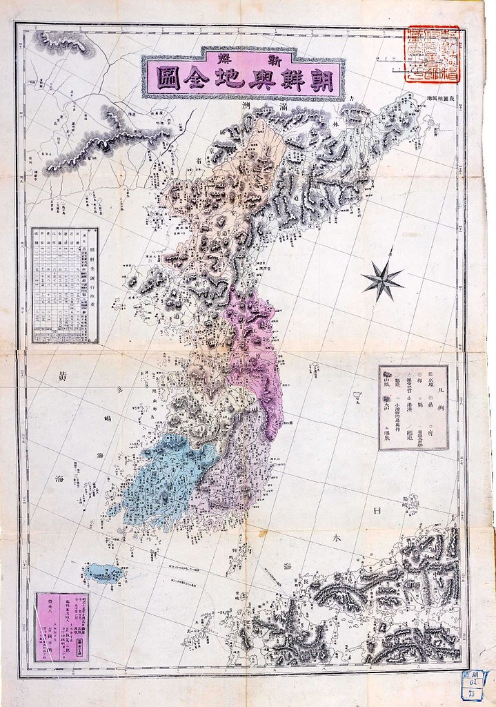
It is same as we saw in 「新撰朝鮮全図(Newly Made Whole Map of Chosun Country) 」 (1894). Last time, he claimed Japanese recognized this "Matsushima" is Korean since it is coloured in the same with Choson. This time, it is uncoloured just like Japan. What Prof. Hosaka would explain this time?
Anyway, though I think those private maps cannot be any evidence to claim sovereignty even uncoloured, but they are very important to understand the history of the Japanese recognition of the islands around that period.
This comment has been removed by the author.
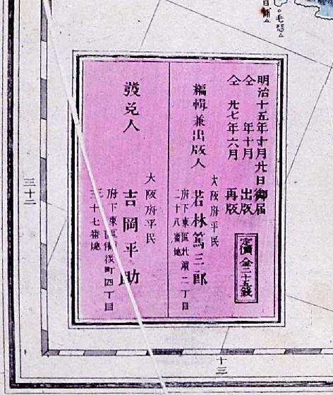
ReplyDeleteBy the way, I think the title 新撰朝船輿地全圖 should be 新撰朝"鮮"輿地全圖. And the name of the author should be Wakabayashi Saburo (若林三郞).
ReplyDeleteThank you, Kaneganese. I have made the corrections.
ReplyDeleteKaneganese,
ReplyDeleteI just got the map off the Korean National Library Web site.
Regardless of any mismappings, the important thing about these maps is that they show Usando (于山島) as a neighboring island of "Ulleungdo," while also showing Matsushima (松島) as a separate island. This is evidence that the Japanese did not think Usando was referring to Liancourt Rocks.
Good evening,Mr.Bevers,
ReplyDeleteAccording to the third picture,
the name of the author is 「若林篤三郞」(Wakabayashi Tokusaburo ).
Thank you, Chaamiey. I changed the name to the one you suggested.
ReplyDeleteIf anyone has any comments about it or finds any more errors, please let me know.
1928年日本国発行の教科書に拠ると、獨島は朝鮮のものとして表記されてる。
ReplyDeleteGerry Bevers wrote "It appears the mapmaker believed Takeshima (Ulleungdo) to be the non-existent island of Argonaut."
ReplyDeleteIt’s wrong to say the Japanese mapmaker believed Takeshima (Ulleungdo) to be the non-existent island of Argonaut which was the result of westerner’s mismapping.
The mapmaker of the above map clarified Takeshima was Ulleongdo by lebeling (竹島 一名 鬱陵島) next to 竹島. The Japanese traditionally (until 1905) believed Takeshima to be Ulleongdo, the neightboring island of Dokdo, not the non-existent island of Argonaut. Then, what is Matsushima in this map? Absolutely, there’s no doubt Matsushima is Dokdo. To Japanese, Matsushima was the name for Dokdo until 1905.(There were very few exceptions, but it wasn’t general at all.)
Why is Matsushima in the shape of Ulleongdo in this map? It was the result of copying the errored western maps. It’s no wonder most Japanese mapmakers of 19th century didn’t know the exact shapes of Ulleongdo and Dokdo because the Japanese were not allowed to travel to those islands in 1696. They simply cipied the western maps which mismapped Ulleongdo.
The fact Usando was depicted at the west to Ulleongdo indicates the mapmaker didn’t have the exact knowledge about Usando.
This map is one of the significant maps in proving Japanese claim Takeshima in some 19th century Japanese maps was not Ulleongdo because it was depicted in the wrong position as Kaneganese did in the post here.