 Fr. Claude-Charles Dallet described eastern limit of Korea as 130°50’E, which exclude Takeshima/Dokdo in his book "Histoire de L'Eglise de Corée (History of the Korean Catholic Church). "(1874).
 "Histoire de L'Eglise de Corée" (1874)
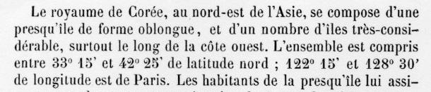
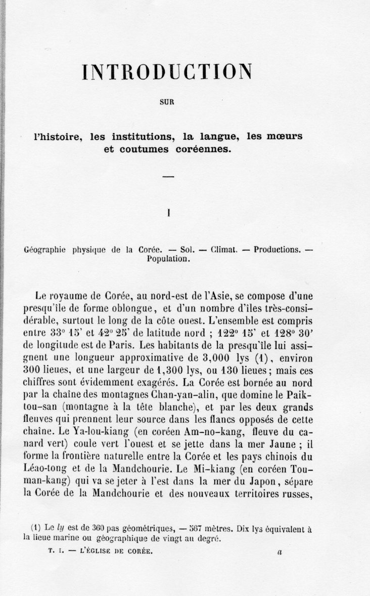
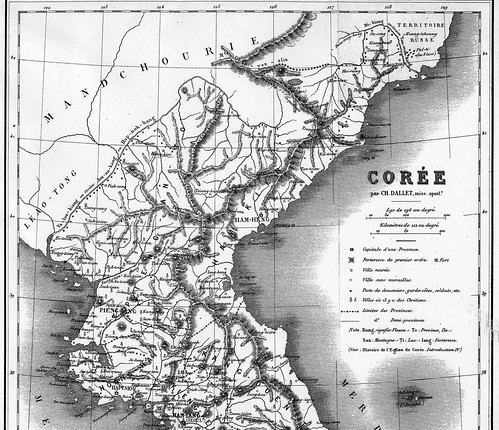
Geographie physique de la Corée Le royaume de Corée, au nord-est de l'Asie, se compose d'une presqu'île de forme oblongue, et d'un nombre d'îles très-considérables, surtout le long de la côte ouest. L'ensemble est compris entre 33°15’ et 42° 25’ de latitude nord ; 122° 15’ et 128°30’ de longitude est de Paris. ( 128°30’ E+ 2°20’(Eastern longitude of Paris) = 130°50’E (Greenwich Meridian))
 Moreover, the map attached to this book clearly depicts "Ou-san(Usan)" next to "Oul-leng-to (Ulleundo)", the exact location of today's Jukdo, not today's Takeshima/Dokdo which locates at 131”50’E. Besides, you can clearly see that "Oul-leng-to (Ulleundo)" and "Ou-san(Usan)" consist one "Dagelet Island". Liancourt Rocks were never thought to be Dgelet island. Notice that the map also includes lines of longitude and latitude, which eliminate any possibility that “Ou-san” could have been referring to Liancourt Rocks (Dokdo) (Lies, Half-truths, & Dokdo Video, Part 7). Those facts show French who saw Korean old maps and western maps considered Usando is today's Jukdo, just like us. It coincide with the fact that there is no single document that show Korean themselves thought Usando is today's Takeshima/Dokdo, but a neighbouring island of Ulleundo.
Dallet explains about the map as follows. (Thanks to matsu for the information.)
Celle que nous donnons en tête de cet ouvrage a été dressée, pour le littoral, d’après les cartes du dépôt de la marine, et pour l’intérieur du pays, d’après une carte indigène assez récente, tranduite par Mgr Ridel, vicaire apostolique de Corée.This is very important for the Takeshima/Dokdo dispute since the islets "Liancourt Rocks" were re-found and already charted by the French whaling ship Liancourt in 1849. In other words, this map proves even french Navy was almost certainly recognized "Usando" was Jukdo, not Takeshima/Liancourt Rocks/Dokdo and excluded the islets from Korean territory.(The coastal place of this map was made by the maps of Navy and inland was by the vicar apostolic Ridel's translation of relatively recent map by local. )
Supplement
Below are the informations on the author Dallet and this book I found on the net.
Claude-Charles Dallet was born in Langres, France, 18 October 1829. He entered the Se'minaire des Missions E'trange`res in 1850, and was ordained 5 June 1852. Though he spent his missionary life mainly in Asia, including India, he had never been to Korea. This book is mainly based on the materials collected by Msgr. Daveluy who was executed in Seoul in 1866.Charles Dallet wrote this book, as he very clearly spells out in his preface, on the basis of letters and other communications received in Paris between 1836 and 1863 from the missionaries in Korea. In what must have been an intricately planned operation, Korean Catholic fishermen took the mail out to sea and passed it to Chinese Catholic fishermen who took it to Shanghai, whence it was dispatched to Hong Kong, where the Societe' des Missions E'trange`res had an agent, who posted it to Paris. This route was apparently pioneered and developed by Kim Tayken, Korea's first Catholic priest, who studied and was ordained in China. From 1836 on, all French priests who entered Korea, or in 1866 those who fled it, did so by sea. The Korean authorities had long since established virtually impenetrable security at the northern frontier, at least in so far as Europeans were concerned. (Gari Ledyard , Wiki : Japanese )
I didn't have much skill and time to put two partial maps together. Sorry for any inconvenience.
ReplyDeleteThank you, Matsu for the information. If you find any mistakes, please let me know.
matsuさん
ありがとうございました。何か間違いを見つけたら、ご指摘下さいますよう、お願いします。
Kaneganeseさん
ReplyDeleteありがとうございます。立派にポストしていただきました。
パリは、東経2度20分(2度19分59秒と書いてあるものも多い)ですので、
この本に書かれている東経128度30分(パリ基準)に、
パリの経度2度20分を足すと、グリニッジ基準の東経130度50分となります。
(128°40′は128°30′です。また130”50’Eは130°50’Eです。)
さらに、Gerry Beversさんが、ずっと以前に上記のところで指摘されていたことですが、
一番下の拡大図を見るとよくわかるように、
この図にあるOu-san(于山)は、明らかに<Dagelet>(=鬱陵島)という文字で示された範囲の中に含まれており、92キロ離れたTakeshima/Liancourt Rocks/ Dokdoではないことが良くわかります。
That is a good post, Kaneganese.
ReplyDeleteKaneganeseさん、
ReplyDelete訂正ありがとうございます。
パリが東経2度20分であることと、足し算をすると130度50分になることを、本文のどこかで記しておいたほうが、よりわかりやすいか、とも思います。
でも、おまかせします。
あと、フランス語特有のの「アクセント」の記号がうまく打てなかったので、恥ずかしながら、ずいぶん抜けています。原文と照らし合わせて、正しく直さないといけないと思います。
さて、この本のほかにも、緯度・経度を記した「洋書」はたくさんあると思います。
「世界の常識」をたくさん集めましょう!
Thank you,Gerry
ReplyDeletematsu さん
修正してみました。それから、après, asséz, Corée以外にありましたでしょうか? 実は、このページをコピーしてくるのを忘れてしまったのです。教えて頂ければ大変助かります。(フランス語、ほとんど覚えていないことに愕然としています。何となく意味は判るのですが。)
Kaneganese-san,
ReplyDelete以下のように訂正してください。
海軍の地図は複数です。
Celle que nous donnons en tête de cet ouvrage a été dressée, pour le littoral, d’après les cartes du dépôt de la marine, et pour l’intérieur du pays, d’après une carte indigène assez récente, tranduite par Mgr Ridel, vicaire apostolique de Corée.
matsuさん
ReplyDelete修正しました。ありがとうございました。
Kaneganese, as usual your post has serious problems.
ReplyDeleteDont' you think your interpretation is a little bizarre?
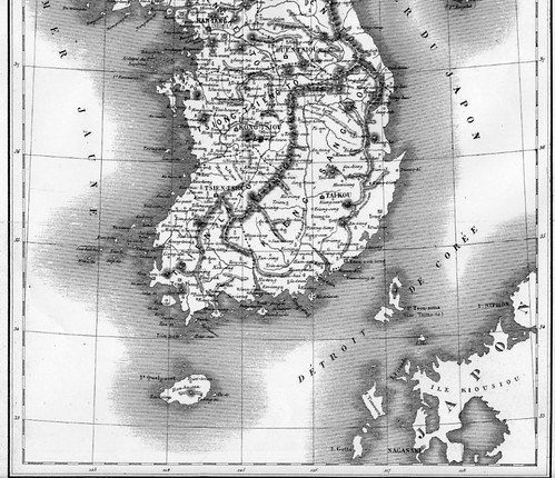
Look at the map again. Where are Liancourt Rocks? There is easily enough room that if this map was an accurate chart, Dokdo Takeshima should be included to the East of Ulleungdo but it is not. If you say the French Navy had any influence on this map Liancourt Rocks should be on this map Kaneganese.
In reality the French Navy used the map drawn by the Russian Putyatian Fleet shown here. The French published the map below twice, once by the French Navy.
Dokdomap1
With regard to Ulleungdo and Usando, the French mapmaker copied crude Chosun maps of Ulleungdo and combined this data with some information they gathered while working as missionaries in Korea.
The boundary of Chosun on with relation of this map is the northern tip of the Korean peninsula NOT Ulleungdo. Look again at the northern tip of Korea it is at 128.30 while Ulleungdo Usando are further to the West at about 128.20.
Ulleungdo and Usando at 128.2 Note the red line at 128.3
Ulleung@120.2
In reality Ulleungdo Island extends beyond the northern tip of the Korean territory.