The book pictured on the left was a Korean geography book entitled, "Chodeung Daehan Jiji," (初等大韓地誌 - 초등대한지지), which translates as "Elementary Level Geography of the Korean Empire." It was written by An Jong-hwa (安鍾和) and Yu Geun (柳瑾) and published in November 1907 as an elementary school geography book. It is stored in the National Libarary of Korea.
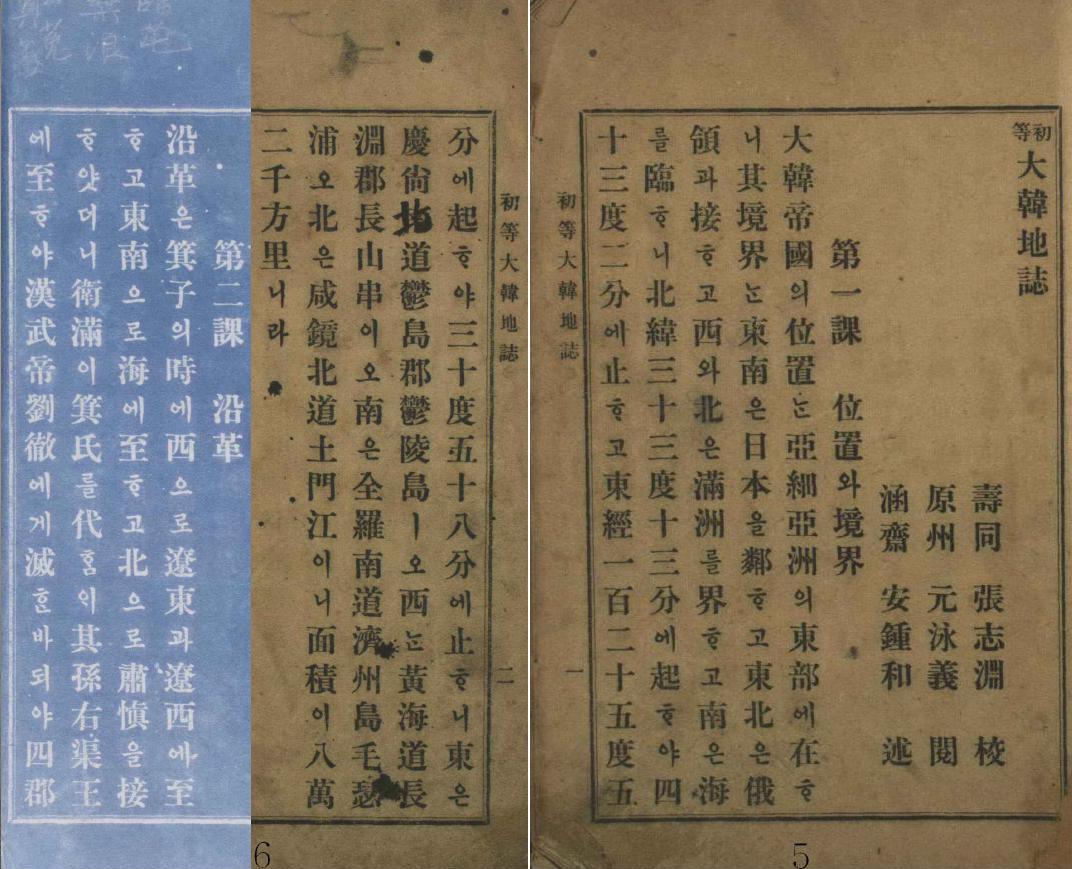
The book has only forty-three pages that are divided into twenty-four chapters. The first chapter is entitled "Location & Boundaries" and gives the location of Korea in relation to its neighbors in East Asia. It then gives the north-south, east-west latitudes and longitudes of the farthermost points of Korea, and then lists the names of those points. Korea's easternmost point was described as the island of Ulleungdo in Uldo County of North Gyeongsang Province (慶尙北道 鬱島郡 鬱陵島 -경상북도 울도군 울릉도).
Korea claims that Liancourt Rocks were a part of Uldo County (鬱島郡 - 울도군) and were referred to as "Seokdo" (石島 - 석도), but they have no evidence to support their claim. Moveover, the longitude given for Korea's easternmost point in the above geography book excludes Liancourt Rocks from Korean territory. Also, it lists the island of Ulleungdo in Uldo County as being Korea's easternmost point. If Liancourt Rocks had really been a part of Uldo County, then they would have been listed it as Korea's easternmost point. The fact that they were not listed is more evidence against the Korean claim.
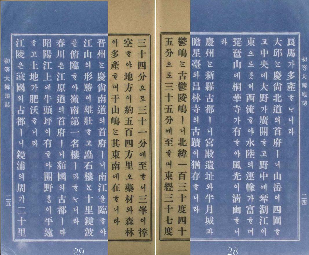
The geography book also mentioned the island of Ulleungdo in more detail in Chapter Twenty-two, which was entitled "Scenic Communities" (勝地 都會 - 승지 도회). The description gave the longitude of Ulleungdo as extending from 130 degrees 35 minutes to 130 degrees 45 minutes, but Ulleungdo, including its neighboring island of Jukdo (竹島 - 죽도), actually extends from approximately 130 degrees 47 minutes to 130 degrees 57 minutes. This suggests that the longitude given for Ulleungdo in this chapter was an older, less accurate measurement than the one in Chapter One, which described Ulleungdo's eastern boundary as being at 130 degrees 58 minutes. The description in Chapter 22 also mixed up the names for latitude and longitude.
Ulleungdo was also described in Chapter Twenty-two as having an island named "Usando" (于山島 - 우산도) to the southeast, but no distance was given. Liancourt Rocks is ninety-two kilometers to the southeast of Ulleungdo at a longitude of 131 degrees 52 minutes, which is way outside the boundary the book gave for both Ulleungdo and for Korea's easternmost point.
It is possible the Usando mentioned in the geography book was referring to Liancourt Rocks (Dokdo), but it is also possible that it was referring to Ulleungdo's neighboring island of Jukdo (竹島 - 죽도). Usando was the old Korean name for Jukdo, which is about about 2.2 kilometers off the east shore of Ulleungdo. Actually, by 1907, Koreans on Ulleungdo were supposedly referring to Liancourt Rocks as "Dokdo" (獨島 - 독도) or by the Japanese name of "Yangko-do," while the original location of Usando had already been forgotten. (See "Location of Usando Unknown in Early 1900s.")
The following is my English translation of the relevant passages from the 1907 geography book. It is followed by the Korean text.
Chapter 1: Location and Boundaries
The Korean Empire is located in the eastern part of Asia. Its neighbor to the southeast is Japan, and it borders Russian territory on the northeast. The west and north border Manchuria, and the southern border faces faces the sea. Its northern latitude stretches from 33 degrees 13 minutes to 43 degrees 2 minutes. Its eastern longitude stretches from 125 degrees 50 minutes to 130 degrees 58 minutes. The eastern point is Ulleungdo in Uldo County of North Gyeongsang Province, and the western point is at Cape Jangsan in Jangyeong County in Hwanghae Province. The the southern point is Port Moseul on the island of Jeju in South Jolla Province, and the northern point is Tomun River in North Hamgyeong Province. The area is 82,000 square ri.
Chapter 22: Scenic Communities
Uldo is the old Ulleungdo. Its northern latitude stretches from 130 degrees 45 minutes to 35 minutes. It’s eastern longitude stretches from 37 degrees 34 minutes to 31 minutes. Three peaks prop up the sky. Its area is about 504 square ri. It produces many medical herbs and much timber. Usando is southeast of here.
-----------------
第一課 : 位置와 境界大韓帝國의 位置는 亞細亞洲의 東部에 在하니 其境界는 同南은 日本을 鄰하고 東北은 俄領과 接하고 西와 北은 滿洲를 界하고 南은 海를 臨하니 北緯三十三度十三分에 越하야 四十三度二分에 止하고 東經一百二十五度五十分에 越하야 百三十度 五十八分에 止하니 東은 慶尙北道 鬱島郡 鬱陵島이오 西는 黃海道長淵郡 長山串이오 南은 全羅南道 濟州島 毛瑟浦 [摹瑟浦]오 北은 咸鏡北道 土門江이니 面積이 八萬二千方里니라.
第二十二課 : 勝地 都會
鬱嶋는 古鬱陵島이니 北緯 一百三十度 四十五分으로 三十五分에 至하며 東經三十七度 三十四分으로 三十一分에 지하니 三峯이 撑空하야 地方이 約 五百四方里오 藥材와 森林이 多産하며 于山嶋는 其東南에 在하니라.
I have posted a translation of the 1907 Korean geography book "Chodeung Daehan Jiji" (初等 大韓地誌). If anyone finds any mistakes, please let me know.
ReplyDeleteGerry,
ReplyDeleteThanks. Kaneganese once mentioned the textbook in her posting but I've never seen this before.
http://dokdo-or-takeshima.blogspot.com/2008/06/korean-eastern-limits-described-in.html
This is one of the very important evidences because it was published before the annexation, and it was published by the official educational bureau of Korean Empire, not by Japanesse government.
gerry, juuno, mycoree,
ReplyDeletehttp://img99.imageshack.us/img99/8412/ulleungdokb6.jpg
gerry,
당신의 엉터리 한문 번역은 더이상 보지 않아도 되겠군요.
자료를 제대로 해석하려면, 논리가 필요합니다. 상황에 맞는 상식도 필요합니다. 또한, 실제로 그 자료가 정확한지 검증해봐야 합니다.
Lord,
ReplyDelete제 번역은 틀린 것이 있으면 어디에 틀린지 말씀해주시면 고칠 수 있습니다.
그리고 당신이 link한 그림이 틀린 논리입니다."우산울릉양도"는 울릉도과 그 바로 옆에 있는 죽도였습다. 둘 다 보이는 것이 아니었고 그 두 섬이 한 섬으로 보는 것이었습니다. 다음 두 지도를 참고하십시오.
18세기 - "Yeojido" (輿地圖 - 여지도)
"Gwangyeodo" (廣輿圖 - 광여도)
우산도는 독도가 아니었습니다.
gerry,
ReplyDelete당신들이 항상 말하던 거짓말은 어디에 갔습니까?
+++++
鬱陵于山両島 天気清明蔚三両地登高皆見
鬱陵于山両島: Ulleungdo 와 Usando의 양쪽 모두
天気清明: 날씨가 좋다면
蔚三両地: 蔚珍(울진)・三陟(삼척) 두 개의 장소에서
登高皆見: 높은 곳에 오르면 모두 보인다
+++++
위의 문장은 pacifist가 번역한 것입니다.
pacifist가 나에게 거짓말을 했다는 것입니까? 하하하
-----
gerry, 저는 당신이 한국에 있는 것이 싫습니다. 저는 당신을 협박하는 것이 아닙니다. 일본으로 가주세요.
gerry,
ReplyDelete당신이 지도를 link 한 것처럼 하려면, 어떻게 해야 하는지 알려주세요.
저도 Mouse를 click하면 지도를 볼 수 있게 하고 싶습니다.
Lord,
ReplyDelete다른 데 가서 알아보십시오. 당신은 제 친구가 아닙니다.
gerry,
ReplyDelete당신을 친구로 생각한 적이 없습니다. 하하하
제발 다른 나라에 가서 활동하세요.
張志淵 also wrote Usando is Ulluengdo in another writing.
ReplyDeleteAnyone know when he wrote this text?
韋庵文稿卷之九 外集
社説中 東事考略十五篇
讀史有感
于山國
按東史, 新羅 智證王十三年, 討服于山國, 于山在溟洲正東海中, 卽今鬱陵島, 地方不過百里, 恃其險不服, 伊飧 異斯夫率甲兵十餘人, 以木造獅子百許頭, 塗飾金彩, 載之戰船, 抵其島誑之曰, 汝若不降, 卽放此獸蹯殺之, 國人大懼乃降, 恃險不服者, 始何强項, 大懼乃降者, 終何柔腸耶, 料其山河之固, 足以不受敵, 城池之壯, 足以堅其守, 人民戰士之能作捍禦者, 審其衆寡强弱之勢, 知其不能攻, 然後可以不服, 海上孤島小如點墨者, 所恃維何, 而徒恃其險, 可知其民之愚也, 見其甲士之猛, 足以蹂躪, 戰船之多, 足以衝擊, 金毛獅子之能售悍獰者, 究其眞假詐正之跡, 知其不能制, 然後可以乃降, 幻目奇怪, 一言威嚇者, 所懼維何, 而大懼乃降, 可知其民之昧也, 其民愚且昧, 而其國不二者, 自古及今未之有也, 比今世界以觀之, 大小强弱相與聯肩, 其民不愚昧, 則始而不恃, 相與和好, 終而不懼, 相與椅角, 故小與大相抗, 弱與强相立, 其民愚昧, 則始而未嘗不恃, 終而未嘗不懼, 小爲大吠, 弱爲强幷, 其民愚昧之甚, 則不惟小者弱者, 大者强者亦至呑幷, 不必遠求, 泰西之波蘭可謂大者强者, 其民愚昧, 故終爲呑幷於俄普奧, 現今支那之淸國, 亦可謂大者强者, 其民愚昧, 故方見敗陷於聯合軍, 未知幷呑於誰手, 其民愚昧, 而其國必亡之證, 昭然可據, 如今木造獅子之威嚇, 羅列前後, 不啻一二民之愚昧甚于于山, 可不憂哉, 有國者急先敎民, 開其愚昧, 能知木獅之眞假詐正, 豈非存國興亡之大基本哉。
Gerry,
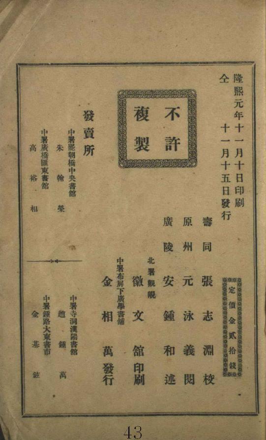
ReplyDeleteThanks for showing the inside of the back cover. It seems that this was published by a Korean publisher and was adopted to a textbook.
It seems that the translation didn't include a big mistake. Most importantly, the sentences relating the location of Korean Empire seems correct. It apparently excluded Liancourt Rocks.
GTOMR,
ReplyDeleteJang Ji-yeon died in 1921, but after his death others collected and compiled his writings into a 12-volume set of books called, "Wui-am Mugo" (韋庵文稿). Supposedly, they applied to have the books published during Korea's colonial period, but the Japanese authorities wanted to delete certain parts, so they were not published until 1956.
Anyway, he would have had to write the document sometime during his lifetime, which was from 1864 to 1921.
Thanks Gerry
ReplyDelete張志淵 also published 大韓新地誌 on 1907, which discribes Usando in southeast of Ulluengdo, like 初等大韓地誌, however, he wrote Usando is another old name of Ullunegdo, in the 韋庵文稿卷之九 外集 社説中 東事考略十五篇 讀史有感 于山國, partly referenced text from 三国史記 and so on.
GTOMR,
ReplyDeleteI will translate the 大韓新地誌 later.
I have to get some sleep.
Good night, GTOMR and Pacifist.
이제 당신들이 절대 부정할 수 없는 증거와 논리가 존재하게 되었습니다.
ReplyDelete우산도의 이름의 혼동은 있었지만, 그렇다고 사실이 달라지지는 않습니다.
+++++
pacifist said... 12:09 PM
鬱陵于山両島 天気清明蔚三両地登高皆見
鬱陵于山両島: Ulleungdo 와 Usando의 양쪽 모두
天気清明:날씨가 좋다면
蔚三両地:蔚珍・三陟두 개의 장소에서
登高皆見:높은 곳에 오르면 모두 보인다
즉, 이 문장에서도 Usando는 한반도로부터 보인다고 쓰고 있습니다.
+++++
울릉도의 높이 : 984m
죽도의 높이 : 106m
울릉도의 면적 : 72.56㎢
죽도의 면적 : 0.207869㎢ = 207,869㎡
http://img99.imageshack.us/img99/8412/ulleungdokb6.jpg
죽도의 위치: 울릉도의 동쪽 한가운데 2.4km 떨어져서 죽도가 있습니다.
따라서 죽도는 한반도 동쪽에서 절대 보이지 않습니다.
++++++
한국에도 충분한 자료가 있습니다.
당신들의 거짓말을 기본부터 증명했습니다.
이제 한국의 다른 분들이 이 논리를 어떻게 사용할 지 기대됩니다.
당신들의 논리는 이제 더 이상 안통합니다.
lord,
ReplyDelete울진으로부터 독도까지의 거리는 약 215킬로미터입니다.
울진의 비싼 지점에 올라도, 독도는 수평선하에 숨어 보이지 않습니다.
3척은 더 거리가 있습니다.
따라서, 당신의 이야기는 수학적으로 파탄하고 있습니다.
小嶋日向守,
ReplyDelete나의 이야기에 문제가 있다고 생각합니까?
하지만, 근본적으로 당신들의 한가지 문제점은 해결했습니다.
죽도는 한반도 동쪽(삼척, 울진)에서 절대로 보이지 않습니다.
나는 그것을 증명했습니다.
앞으로 죽도가 보인다는 이야기는 절대로 하지 마시기 바랍니다.
小嶋日向守,
ReplyDelete그리고, 당신들의 한문 해석에도 이제 죽도를 언급하지 마시기 바랍니다.
더 이상 당신들의 주장은 근거가 없습니다.
This comment has been removed by the author.
ReplyDeleteThis comment has been removed by the author.
ReplyDelete당신의 계산은 잘못하고 있습니다.
ReplyDelete독도의 최고점을 157미터로서
독도가 보이는 고도는, 울진(215킬로미터)에서는, 해발 1900미터 필요합니다.
고도 1567미터의 산의 정상으로부터, 독도를 보기 위해서는, 산과 독도와의 거리는, 200킬로미터 이하가 아니면 안됩니다.
http://www.kaisho.com/nki_data/cul/gankou/nav2.html
http://www.coara.or.jp/~chemi/radio/jf6zwm/dx.htm
This comment has been removed by the author.
ReplyDeletelord,
ReplyDelete한국측의 주장에 호의적인 인물의 사이트를 소개합니다.
http://www.ne.jp/asahi/cccp/camera/HoppouRyoudo/Other/Ullundo/Ullun.htm
나는, 울진으로부터 독도가 안보이는 말을 합니다.
ReplyDelete타이하쿠산으로부터도 독도는 보이지 않습니다.
울릉도로부터 독도는 보입니다.
http://www.ne.jp/asahi/cccp/camera/HoppouRyoudo/Other/
ReplyDeleteUllundo/Ullun.htm
小嶋日向守,
ReplyDelete당신의 주장을 인정합니다.
지구의 반지름을 6400km로 계산해서,
2289m가 되어야 독도를 볼 수 있습니다.
그렇기 때문에, 세종실록지리지에서 기록을 바꾼 것입니다.
pacifist의 글에서 봤습니다.
세종실록 이전에는 울진과 삼척에서 두 섬을 볼 수 있다고 기록했습니다.
하지만, 세종실록지리지에서는 두 섬이 서로 가까워 맑은 날씨에 볼 수 있다고 기록했습니다.
이제야 이유를 알겠습니다.
하지만, 당신들이 말하는 죽도는 한반도에서 보이지 않습니다.
lord,
ReplyDeleteKawakami Kenzo didn't actually say Takeshima/Dokdo cannot be seen from Uleungdo. If you insist he did and use distorted logics of Korean so-called professors, please show me the original writing of him, not Korean. Or you are practically slandering him. I know you can't because I know what he actually wrote. Don't use Korean prosessors logics without checking original documents.
Besides, being able to see Jukdo from pennisula or not is not important at all, since until the end of 17C, Ulleungdo and Usando was considered to be one island or one island group. Those Korean old documents are saying Ulleungdo's trees and seashores can be seen from peninsula on a clear fine day, not Jukdo. It doesn't match with the situation of Takeshima/Dokdo from Ulleungdo at all, anyway.
小嶋日向守 & Kaneganese,
ReplyDelete한반도에서 죽도는 보이지 않습니다.
한반도에서 독도도 보이지 않습니다.
이제 이 두가지는 사실은 모두가 인정할 수 있군요.
lord,
ReplyDeleteI said you need to give us the evidence Kawakami said Takeshima/Dokdo cannot be seen from Ulleungdo.
And I also said that Korean documents are not saying Jukdo nor Takeshima/Dokdo can be seen from peninsula. It's Ulleungdo, whose alias name of ancient times were Usando. Usando was not Jukdo until 1700s.
Read below.
1452年 - 「高麗史」巻五十八 地理三
"在縣正東海中 新羅時 称于山国 一伝武陵、一伝于陵 一云 于山 武陵 本二島、相距不遠 風日清明 則可望見"
1454年 - 「世宗実録」 地理志 江原道襄陽縣
"于山 武陵 二島 在縣正東海中 二島相去不遠 風日清明 則可望見 新羅時 称于山国 一云鬱陵島 地方百里 恃険不服"
Usando/Ulleungdo in those documents were actually Ulleungdo or Ulleungdo group, not Jukdo alone. The real fact is, Ulleungdo can be easily seen from Korean peninsula on a fine day just like "高麗史 巻五十八 地理三" and "世宗実録 地理志 江原道襄陽縣" says.
We can easily verify the fact in various Korean old documents. Actually, it was very common recognition recorded in many Korean old documents.
On the other hand, Takeshima/Dokdo cannot be easily seen from Ulleungdo even on a fine and clear day unless you got very lucky because it can be seen only a few days a year. There is only one documents which recorded Korean saw Dokdo/Takeshima from Ulleungdo before 1900s. (張漢相' 1694 report of Ulleungdo inspection).
1481年 - 「東国輿地勝覧」巻四五
"蔚珍縣 于山島 鬱陵島 一云武陵 一云羽陵 二島在県正東海中 三峯及業掌空 南峯梢卑 風日清明則峯頭樹木 及山根沙渚 歴々可見 風便則二日可到 一説干山 鬱陵 本一島 地方百里"
1530年 - 「新増東国輿地勝覧」
"蔚珍縣 于山島 鬱陵島 一云武陵 一云羽陵 二島在県正東海中 三峯及業掌空 南峯梢卑 風日清明則峯頭樹木 及山根沙渚 歴々可見 風便則二日可到 一説干山 欝陵 本一島 地方百里"
The description never fits with the REAL situation of Takeshima/Dokdo from Ulleungdo, but Ulldungdo from peninsula.
Moreover, in 1694, when the dispute over Ulleugdo occured between two countries, Korean Joseon official cited the exact sentence and claimed that Ulleungdo is Korean territory since it says that Ulleungdo can be seen from Korean peninsula in "輿地勝覧書"
Read below.
1694年 - 粛宗實録 20年8月13日
" 朝鮮国礼曹参判李番、奉復日本国対馬大守平公閣下、槎使鼎来、恵□随至、良用慰荷弊邦江原道蔚珍県有属島、名曰蔚陵(=鬱陵島)、在本県東海中、而風濤危険、船路無便、故中年移其民空其地、而時遣公差往来捜検矣、本島峰巒樹木、自陸地歴々望見、而凡其山川紆曲、地形濶狭、民居遺址、土物所産、倶戴於我国輿地勝覧書、歴代相伝、事跡昭然、今者我国辺海漁氓往其島、而不意貴国之人自為犯越、与之相値、反拘執二氓、転到江戸、幸蒙貴国大名明察事情、優加資此、可見交隣之情於尋常、欽□高義、感激何事、然雖我氓漁採之地、本是蔚陵島(=鬱陵島)、而以其産竹、或称竹嶼(=鬱陵島)、此之一島而二名也、一島二名之状、非徒我国書籍之所記、貴州人亦皆知之、而今此来書中、乃以竹島為貴国地方欲令我国禁止漁船更往、而不論貴国人侵渉我境、拘執我氓之夫、豈不有欠於誠信之道乎、深望将此辞意転報東武、申飭貴国辺海之人、無令往来蔚陵島、更致事端惹起、其於相好之誼不勝幸甚、佳領謝、薄物侑緘、統惟照亮、不宣"
Choson dynasty in 1694 had ability to read 漢文 and identified that the island which can be seen is Ulleungdo and it is from peninsula, but it seems Korean nowadays lost the ability and became illiterate of 漢文.
lord,
ReplyDeleteWhy can't you even show what actually Kawakami wrote in his book?
Anyway, technically, I have to consider that you admit you lied about Kawakami Kenzo's sentence. Agreed?
All the documents I quoted above are from original Korean documents and I only believe original documents, not the second hand resources like you are continuously doing. Why don't you believe your own ancesters's own documents? All the documents clearly suggest that it is Ulleugndo or Ullgungdo island group that can be seen from Choson peninsula, not Takeshima from Ulleungdo.
If you don't read original documents and rely on the translation done by someone else, especialy Korean so-called scholars, it will cost you a lot. Now I got to know that you haven't even read Kawakami's book though you critisized he said Takeshima cannot be seen from Ulleungdo, which actually he didn't say. I know hanmaumy's crazy anti-Japan site and we've already showed how Hanmaumy misleads readers ages ago by not showing whole documents or showing selectivel documents.
When you come back , please bring your own translation and its original documents.
There was a wrong link in my comments above. I'd like to correct it and add some more links useful.
ReplyDeleteSorry for any inconvenience.
Korean documents are not saying Jukdo nor Takeshima/Dokdo can be seen from peninsula. It's Ulleungdo, whose alias name of ancient times were Usando. Usando was not Jukdo until 1700s.
Read below.
1452年 - 「高麗史」巻五十八 地理三
"在縣正東海中 新羅時 称于山国 一伝武陵、一伝于陵 一云 于山 武陵 本二島、相距不遠 風日清明 則可望見"
1454年 - 「世宗実録」 地理志 江原道襄陽縣
"于山 武陵 二島 在縣正東海中 二島相去不遠 風日清明 則可望見 新羅時 称于山国 一云鬱陵島 地方百里 恃険不服"
Usando/Ulleungdo in those documents were actually Ulleungdo or Ulleungdo group, not Jukdo alone. The real fact is, Ulleungdo can be easily seen from Korean peninsula on a fine day just like "高麗史 巻五十八 地理三" and "世宗実録 地理志 江原道襄陽縣" says.
We can easily verify the fact in various Korean old documents. Actually, it was very common recognition recorded in many Korean old documents. " Visible Ulleungdo from Korean peninsula, not about Liancourt Rocks from Ulluengdo"
On the other hand, Takeshima/Dokdo can hardly be seen from Ulleungdo even on a fine and clear day unless you got very lucky and it is less than 10 days a year on a high place with a direction board sign. Besides, there is only one documents which recorded Korean actually "saw" Dokdo/Takeshima from Ulleungdo before 1900s. (張漢相' 1694 report of Ulleungdo inspection shows Usando is not, Takeshima/Dokdo, but Jukdo.), hence we know that it is "possible" to see Takeshima/Dokdo from Ulleugdo, but "extremely rare".
1481年 - 「東国輿地勝覧」巻四十五
"蔚珍縣 于山島 鬱陵島 一云武陵 一云羽陵 二島在県正東海中 三峯及業掌空 南峯梢卑 風日清明則峯頭樹木 及山根沙渚 歴々可見 風便則二日可到 一説干山 鬱陵 本一島 地方百里"
1530年 - 「新増東国輿地勝覧」
"蔚珍縣 于山島 鬱陵島 一云武陵 一云羽陵 二島在県正東海中 三峯及業掌空 南峯梢卑 風日清明則峯頭樹木 及山根沙渚 歴々可見 風便則二日可到 一説干山 欝陵 本一島 地方百里"
1656年 - 「東国輿地志」巻之七 江原道 蔚珍
"于山島 欝陵島 一云武陵 一云羽陵 二島在県正東海中 三峯及業掌空 南峯梢卑 風日清明則峯頭樹木 及山根沙渚 歴々可見 風便則二日可到 一説干山 欝陵 本一島 地方百里"
The description never fits with the REAL situation of Takeshima/Dokdo from Ulleungdo, but Ulldungdo/Ulleungdo island group, including Jukdo from peninsula.
Moreover, in 1694, when the dispute over Ulleugdo occured between two countries, Korean Joseon official cited the exact sentence and claimed that Ulleungdo is Korean territory since it says that Ulleungdo can be seen from Korean peninsula in "輿地勝覧書"
Read below.
1694年 - 粛宗實録 20年8月13日
" 朝鮮国礼曹参判李番、奉復日本国対馬大守平公閣下、槎使鼎来、恵□随至、良用慰荷弊邦江原道蔚珍県有属島、名曰蔚陵、在本県東海中、而風濤危険、船路無便、故中年移其民空其地、而時遣公差往来捜検矣、本島峰巒樹木、自陸地歴々望見、而凡其山川紆曲、地形濶狭、民居遺址、土物所産、倶戴於我国輿地勝覧書、歴代相伝、事跡昭然、今者我国辺海漁氓往其島、而不意貴国之人自為犯越、与之相値、反拘執二氓、転到江戸、幸蒙貴国大名明察事情、優加資此、可見交隣之情於尋常、欽□高義、感激何事、然雖我氓漁採之地、本是蔚陵島、而以其産竹、或称竹嶼、此之一島而二名也、一島二名之状、非徒我国書籍之所記、貴州人亦皆知之、而今此来書中、乃以竹島為貴国地方欲令我国禁止漁船更往、而不論貴国人侵渉我境、拘執我氓之夫、豈不有欠於誠信之道乎、深望将此辞意転報東武、申飭貴国辺海之人、無令往来蔚陵島、更致事端惹起、其於相好之誼不勝幸甚、佳領謝、薄物侑緘、統惟照亮、不宣"
Gerry Bevers,
ReplyDeleteUlleungdo was also described in Chapter Twenty-two as having an island named "Usando" (于山島 - 우산도) to the southeast, but no distance was given. Liancourt Rocks is ninety-two kilometers to the southeast of Ulleungdo at a longitude of 131 degrees 52 minutes, which is way outside the boundary the book gave for both Ulleungdo and for Korea's easternmost point.
-->
Isn't it ok for you to admit the Usando in this book is Dokdo? There's no other island located to the southeast of Ulleongdo than Dokdo. Jukdo you insist as Dokdo is not to the southeast of Ulleungdo. As for the longitude, it seems the writer had no exact knowledge on the longitude of Ulleongdo, which suggests the longitude described in this book meaningless.
Also, it lists the island of Ulleungdo in Uldo County as being Korea's easternmost point. If Liancourt Rocks had really been a part of Uldo County, then they would have been listed it as Korea's easternmost point. The fact that they were not listed is more evidence against the Korean claim.
-->
You don't have any doubt Jukdo was included in the Uldo County, do you? Then, why didn't this book list Jukdo as Korea's easternmost point? Does it suggest Jukdo was not a part of Uldo County?
The farthermost points of Korea given in this book are not accurate. The westernmost , northernmost and southernmost points of Korea are Ma-ahn Do(馬鞍島), Yu-pho Jin(柔浦鎭) and Ma-ra Do(馬羅島) respectively. This means you can't conclude Dokdo is not the easternmost point because this geography book wrongly gave Ulleongdo as easternmost point of Korea.
I know how hard you try to prove Usando is not Dokdo, but you can't succeed in proving every Usando in Korean old maps and documents isn't Dokdo.