竹島問題の歴史

16.12.11

A Debate with Steve Barber (Frogmouth)

I have been debating Steve Barber (Frogmouth) over at "The Marmot's Hole," where some people there do not like the subject of "Dokdo," so I am posting my last comment to Steve over there to this blog to give him an opportunity to respond here. I have invited him, so we shall see if he comes.

If you are interested in getting some background on the debate, you can go HERE and read up on it.
--------------------------------

Frogmouth wrote (#192):
Wrong very very wrong Mr Bevers. The Shogun did not give permission for Japanese to fish on Ulleungdo 1618. He alternately granted two families, the Oyas and Murakawas permission to voyage there and harvest resources in exchange for tributes. The voyage passes were for going to foreign lands. Japanese did not need permission to voyage to their own country.
The 1618 document was “permission to travel out to sea” (渡海免許) to an outlying island (落島), not to another country. To travel to another country, they would have needed a “red seal document” (朱印狀 – 주인장), which was the custom at the time, but the permission the two families received was not a “red seal document.”

A “red seal document” would have specified the country to which they were traveling. For example, if they were traveling to Korea, the document would have been worded something like this: “自日本到朝鮮國舟也,” which translates as “This ship is from Japan crossing to the country of Korea.” Besides, the only way permitted to travel to Korea at the time was through Tsushima (Daemado), which means “Takeshima” (Ulleungdo) was not considered part of Korea when the document was issued.

Frogmouth wrote (#192):
Saito Hosen’s report says this 州 is the lmilit of Japan. Here “州” means Province NOT place. And it certainly does not mean Ulleungdo Island because Saito Hosen uses the character “島” to mean island. In fact Saito Hosen used “州” consistenly throughout his report to refer to Oki Province.
In the 1667 document, Matsushima (Liancourt Rocks) and Takeshima (Ulleungdo) were considered to be outlying islands of the Oki Domain (隠州), so the Oki Domain was considered to be Japan’s most northwestern territory because it stretched out to within sight of the Korean peninsula. Therefore, the document was not saying that Takeshima (Ulleungdo) was Japan’s most northwestern territory, but that the Oki Domain, which included the outlying islands of Matsushima (Liancourt Rocks) and Takeshima (Ulleungdo), was Japan’s most northwestern territory.

Frogmouth wrote (#192):
Again wrong Mr Bevers. Korea wasn’t even aware Japan was voyaging to Ulleungdo and Dokdo because their was a vacant island policy. When Chosun found out Japan was visiting Ulleungdo they insisted Ulleungdo was theirs and the Japanese immediately agreed. There was no dispute just Japanese compliance. The area was declared off limits. No travel ban to Dokdo was issued because it would literally be suicide to voyage over a week round trip to desolate rocks, with no resources in very heavy seas.
You are being ridiculous, Frogmouth. Of course, there was a dispute over Ulleungdo in the 1690s, after Korean fishermen, including An Yong-bok, were caught fishing on Takeshima, which the Japanese claimed to be their territory. I am not even going to bother quoting all the back and forth between the two countries. The final result was that Japan recognized Takeshima (Ulleungdo) as Korean territory, but not Matsushima (Liancourt Rocks). Afterwards, Matsushima continued to be called “Oki’s Matsushima.”

Frogmouth wrote (#192):
Mr Bevers your assumptions and half-baked conclusions are laughable. Here’s what we know. Jang Han Sang saw Dokdo and gave a quite accurate assessment of its distance. He later stated that he could not see Japan. From these statements we know he did not consider Dokdo as Japanese territory.
Jang Han Sang guessed at the distance to an unnamed island (Liancourt Rocks) on the horizon and he was off by 30 km. His guess of the size of the unnamed island (Liancourt Rocks) was completely wrong since he guessed it to be no more than 1/3 the size of Ulleungdo, when, in fact, it is more like 1/390 the size.

Furthermore, he did not say “he could not see Japan”; he said Japan’s territory was “distant and hazy” (杳茫) with “no islands of significance” (無眼杓之島). Notice the 之 before 島, which means 眼杓 was describing the kind of island he saw. In other words, he saw an island (Liancourt Rocks), but it was “insignificant” (보잘것없는) since it was no more than 1/3 the size of Ulleungdo.

Frogmouth wrote (#192):
Again another incorrect translation from Mr Bevers. The document actually states Visible to the east of Ulleungdo is an island that is near or adjacent to the limits of JapanThus in reality this document shows Dokdo to be near but outside what the Koreans thought to be Japanese territory.
This is probably one of the more ridiculous claims you have made.
The Korean was as following:
鬱陵之東 島嶼相望 接于倭境

East of Ulleung (鬱陵之東 – 울릉지동) a small island is visible (島嶼相望 – 도서상마) that connects to Japanese territory (接于倭境).
接(접) means “to connect,” as in 접(接)하다 or 접속( 接續)하다. 于(우) means “to.” 倭(왜) means “Japanese.” 境(경) means “territory” or “border.” If you put them together you get, “connected to Japanese territory.” There was nothing said about it being “near” Japanese territory.

Frogmouth wrote (#194):
Actually Ulleungdo was incorporated during Shilla in 512 AD but the island was evactuated I think in the 16th Century.
Korea’s “empty island” policy started in 1403, which was the beginning of the 15th century, not the 16th. It lasted until 1883.

Frogmouth wrote (#197):
The measurements given on that report had nothing to do with the dimensions of Uldo County it was simply the size of Ulleungdo Island.
The measurements were for Uldo County because it was the subject of the sentence, Here is the relevant sentence:
該郡所管島는 竹島石島오、東西가 六十里오 南北이 四十里니, 合 二百餘里라고 하였다더라.

[They said] the islands under the jurisdiction of the said county (該郡所管島는) are Jukdo and Seokdo (竹島石島오). From east to west it is 60 ri (東西가 六十里오). From north to south it is 40 ri (南北이 四十里니) for a total of 200 ri (合 二百餘里).
The subject of that sentence is “the county” (該郡 – 해군), not the island. In fact, the whole article is about “Uldo County,” not Ulleungdo island.

Everything you wrote above were lies, Frogmouth, and it was not just because of your ignorance of Korean and Chinese characters. You do it intentionally, for reasons I do not understand.
13.12.11

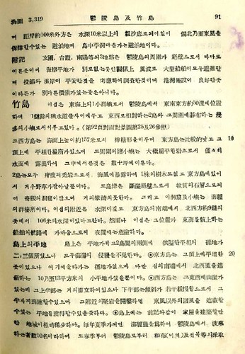
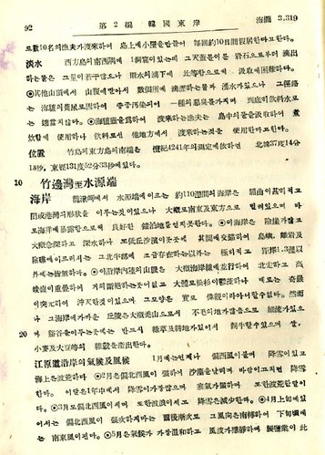
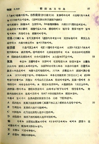
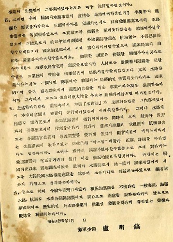
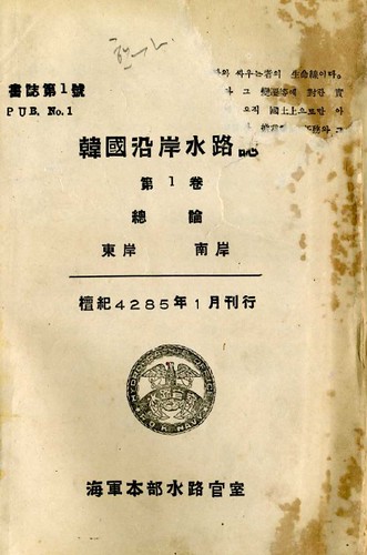
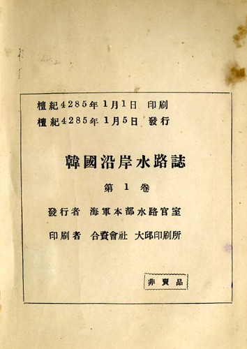
1952 - Jan. - 『韓国沿岸水路誌』第一巻_韓国も竹島を「竹島」と呼んでいた

下の史料は、檀紀4285年1月5日、韓国海軍本部水路官室というところが発行した『韓国沿岸水路誌』です。「竹島」という名前で、竹島=独島が説明されています。(檀紀4285年は1952年です)

1952 01 『韓国沿岸水路誌』第一巻_11952 01 『韓国沿岸水路誌』第一巻_21952 01 『韓国沿岸水路誌』第一巻_51952 01 『韓国沿岸水路誌』第一巻_91952 01 『韓国沿岸水路誌』第一巻_31952 01 『韓国沿岸水路誌』第一巻_4

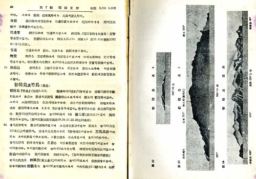
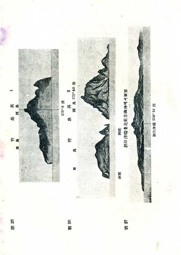
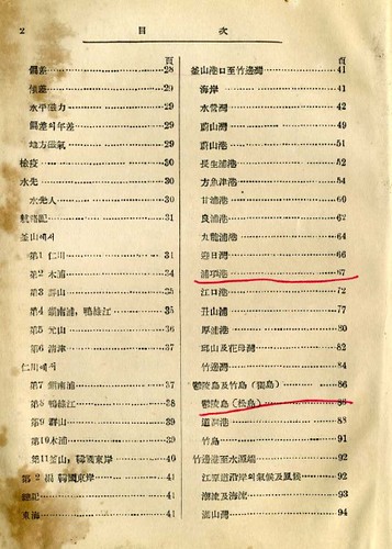
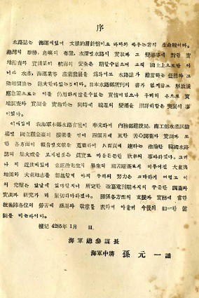
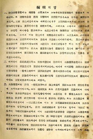
図(表紙、奥付、「竹島」の部分、「鬱陵島と竹島」の部分)

同じ1952年の1月18日には、李承晩ラインが宣言され、韓国は竹島を自国領と主張しました。この本が編集・刊行されたのは、まさにその直前、ということになります。「竹島」の写真もあり、まさしく、今の竹島=独島です。

1952 01 『韓国沿岸水路誌』第一巻_7

図(「竹島」の写真)2枚

項目名は「鬱陵島と竹島(獨島)」となっていますが、「竹島」の説明部分には「獨島」の名前はありません。目次でも、大きな項目として「鬱陵島と竹島(獨島)」としながら、「竹島」は「竹島」のままです。

1952 01 『韓国沿岸水路誌』第一巻_8

図(目次)

「序」と「編集の言葉」の部分に、今年(=1951年)8月に「海軍水路官室」が出来て、4ヶ月の奮闘の末に、ようやく韓国は自前の『水路誌』を持つことが出来た、と書かれています。それまでは韓国には外国の『水路誌』しかなかった、としています。


1952 01 『韓国沿岸水路誌』第一巻_序1952 01 『韓国沿岸水路誌』第一巻_編集1952 01 『韓国沿岸水路誌』第一巻_編集2

図(序、編集の言葉)

当時の韓国外務省や水産局がプッシュして無理やり李承晩ラインの中に竹島を取り込んだ1952年1月以前には、韓国海軍においては、独島に対する強烈な領有意識はなかったのではないかと思われます。あるいは無関心、と言うべきでしょうか。そして、ここには、「新羅以来の韓国の固有領土である独島が、1905年に日本に奪われ、1945年、解放とともに祖国の胸に帰ってきた」という「独島の物語=神話」は、まだ全く存在しません。

そもそも、この本は、ほとんどが、日本側が出した(海軍省)水路部編『朝鮮沿岸水路誌』(昭和8年=1933年)の翻訳と思われます。4か月でできた、と書いてあることからも、それが伺えます。(右側の四角をクリック 原文を見る)(vol 第3編 朝鮮東岸 鬱陵島及竹島)

しかも、まったくの丸写しではなく、新しい資料が取り込まれており、1951年末ごろの、韓国海軍=韓国政府の、独島=竹島認識の一端がうかがえるものだと思います。

・・・・・・・・・・・・・・・・・・・・・・・・・・・・・

朝鮮沿岸水路誌』(昭和8年=1933)韓国沿岸水路誌』(檀紀4241年=1952)の比較

朝鮮沿岸水路誌(89p)

竹島(タケシマ)   此ノ島ハ日本海上ノ1小群嶼ニシテ島根隠岐島前ヨリ大約86浬、鬱陵島ヨリ東南東方約50浬ニ位シ幅1鏈餘ノ狭水道ヲ隔テテ東西ノ相スル2島ト其ノ周ニ碁布スル幾多ノ小嶼トヨリ成ル(第89頁第25及26参照)。

韓国沿岸水路誌(91p)

竹島     섬은 東海上 1小群嶼로서 鬱陵島에서 東南東方約50浬 位置하며

1鏈餘水道를사이에두고 東西하는2 碁布하는

幾多小嶼로서이루고있다(第92頁第25及26参照)

(翻訳)この島は、東海上の1小群嶼で、陵島より東南東方約50浬に位置し、1余の狭水道を隔てて東西に相対する2島と、その周囲に碁布する幾多の小嶼から成っている。(第92頁対面対景図第25及26参照)

・・・・・・・・・・・・・・・・・・・・・・・・・・・

朝鮮沿岸水路誌(89p)

島上ニハ前記ノ如ク家屋ヲ建築スベキ地極メテ乏シク明治37年11月軍艦馬ノ此ノ島ヲ査セシ際ハ東方島ニ漁夫用ノ菰葺小屋アリシモ風波ノ為甚シク破壊シアリシト謂フ。

毎年夏季ニ至ラバ海驢ノ為鬱陵島ヨリ渡スルモノ十名ノ多キニ及ブコトアリ彼等ハ島上ニ小屋ヲ構ヘ、毎約10日間居スト謂フ。

韓国沿岸水路誌(91p)

島上 前記외같이 家屋建築할만한 地域 稀少하다。毎年夏季가되면

海驢하여鬱陵島에서하는10名이라하며春季부터鬱陵島로부터 和布(미역)及전복採取10名漁夫하며島上小屋을만들어

毎回約10日間한다고한다

(翻訳)島上には、前記の如く、家屋を建築すべき地が極めて稀少である。

毎年夏季になると、海驢猟の為に鬱陵島より渡来する者、数10名と言い、また春季から鬱陵島から和布(わかめ)及び鰒等の採取に10名の漁夫が渡来し、島上に小屋を作り、毎回約10日間、仮居するという。

・・・・・・・・・・・・・・・・・・・・・・・・・

朝鮮沿岸水路誌(90p)

位置 竹島ノ東方島ノ南端ハ明治41年ノ測定ニ據レバ北緯37度14分18秒、東経131度52分33秒ニ在リ。

韓国沿岸水路誌(92p)

位置竹島東方島南端 檀紀4241年測定하면 北緯37度14分18秒, 東経131度52分33秒에있다.

(翻訳)竹島の東方島の南端は、檀紀4241年の測定に依れば、北緯37度14分18秒、東経131度52分33秒にある。     注:明治41年=檀紀4241年=1908

25.11.11

Korea to Build Underwater Park on "Dokdo" to Counter Japanese Claims

According to an article in the Korean newspaper Dong-a Ilbo entitled "Breakwater, underwater park to be built on Dokdo islets," Korea plans to spend about $346 million to build an underwater park on "Dokdo" (Liancourt Rocks - Takeshima) to counter Japan's claim to the the rocky islets. Korea is upset that Japan listed "Takeshima" (Dokdo) as Japanese territory in middle school textbooks and in a "Diplomatic Blue Paper."

Here is my question: "How does building an $346 million underwater park counter Japan's historical claims to "Dokdo"?

31.10.11

"Tokyo teachers union denies Japan's claim to Dokdo." Really?

According to an October 30 article in Korea's Dong-a Ilbo, a "Tokyo teachers union denies Japan's claim to Dokdo." Is the Korean headline true?

Here are what the newspaper says are quotes from the union.
The union said, "If schools teach the (Japanese) government`s unilateral opinion that Takeshima is Japanese territory illegally occupied by Korea, it could instill students with emotional nationalism."

"Dokdo is different from the Senkaku Islands (called the Diaoyu Islands in China), over which Japan has a terrestrial dispute, and the Northern Territory (Japanese name for the Kuril Islands), which is effectively governed by Russia."  
The union added, "The history and civil ethics textbooks published by Ikuhosha, a right-leaning publisher which carries ultra-rightist opinions without reservation over history and territorial issues, distort history and antagonize the Constitution," adding, "Measures must be beefed up to block them from reaching students."

A union source said Friday, "When we teach this part, we will objectively teach students that Korea and Japan have differing views over Takeshima," adding, "We hope to contribute to efforts to find a peaceful resolution."
Instead of "denying Japan's claim to Dokdo," the union seems to be saying that it wants to "objectively teach students that Korea and Japan have differing views over Takeshima."

That's fine, but will they just teach that "Korea and Japan have differing views" or will they also look at the evidence for the two claims? If they just teach that Korea and Japan have differing views on Takeshima, then they are not really teaching anything, are they?

If they were to look at the historical evidence, then they would find that Korea does not really have any to support her claims. Korea has no old maps showing Takeshima (Dokdo), by any name. Korea has no old documents showing that Koreans ever traveled to Takeshima before Japanese started taking them there on Japanese fishing boats in the early 1900s. And the only Korean references to Takeshima before the Japanese incorporated the rocky islets in 1905 are just vague references to a distance, unnamed island being visible from Ulleungdo. The Korean references suggest that Koreans could see the islets, but never traveled to them and even believed them to be Japanese.

Also, did the Tokyo teachers' union really refer to Takeshima as "Dokdo," as is quoted in the Dong-a Ilbo article?

I think Tokyo's teachers' union needs to start doing its job of teaching students the history of Takeshima instead of playing diplomat by ignoring the historical facts just to appease Korea.

18.10.11

1954 Aug 6 - "South Korea, Problem Nation"

In an August 6, 1954 editorial entitled "South Korea, Problem Nation," the Meriden Journal suggested that South Korea was being too bellicose and gave its seizure and occupation of "the Takeshima Islands in the Sea of Japan" as just one example.


7.9.11

"The Ambabassador and VFM Yachi Discuss Liancourt Rock Dispute"

The following is supposedly a SECRET document posted by Wikileaks that describes an April 20, 2006 conversation between former US Ambassador to Japan J. Thomas Schieffer and Japan's Vice Minister for Foreign Affairs Shotaro Yachi concerning the proposed 2006 Japanese maritime survey of waters near Liancourt Rocks (Takeshima/Dokdo). The interesting quote from the document is the following:
2. (S) The Ambassador stated the United States understands that Japan is within its rights under international law. The Koreans are behaving irrationally, and the United States is concerned that they may do something crazy, causing a major problem. Everyone needs to back off, he stressed, to enable the matter to be resolved peacefully. We do not want our two allies shooting at each other, he asserted. The Ambassador advised that he might get in touch with FM Aso later in the day.
Here is the whole document, as posted HERE at The Kyungyang Shinmun web site.
THE AMBASSADOR AND VFM YACHI DISCUSS LIANCOURT ROCK DISPUTE
S E C R E T TOKYO 002154  
SIPDIS
SECDEF PASS TO DUSD LAWLESS
NSC PASS TO D. WILDER AND V. CHA  
E.O. 12958: DECL: 04/20/2026  
TAGS: PREL MARR KS JA 
SUBJECT: THE AMBASSADOR AND VFM YACHI DISCUSS LIANCOURT ROCK DISPUTE  
REF: TOKYO 002098  
Classified By: Ambassador J. Thomas Schieffer. Reason: 1.4 (b)(d).  
1. (S) At 11:00 a.m. on April 20, the Ambassador spoke with VFM Yachi, at Yachi‘s request, regarding simmering tensions between Japan and the ROK over a planned Japanese maritime survey near the disputed Liancourt Rocks (reftel).  
He explained, briefly, that the ROK intended to propose to an international commission in June that features on the bottom of the sea in the disputed area be given Korean names. Japan wants to survey the area in order to make a counter-proposal at the meeting. Korea, Yachi stated, may use force to block the survey ship. Yachi further noted that he might travel to Seoul the following day, April 21, to try to resolve the matter peacefully.  
2. (S) The Ambassador stated the United States understands that Japan is within its rights under international law. The Koreans are behaving irrationally, and the United States is concerned that they may do something crazy, causing a major problem. Everyone needs to back off, he stressed, to enable the matter to be resolved peacefully. We do not want our two allies shooting at each other, he asserted. The Ambassador advised that he might get in touch with FM Aso later in the day.  
3. (C) Yachi thanked the Ambassador for his concern and said he would do his best. He requested that the Ambassador send an Embassy representative to the Foreign Ministry to hear Japan’s position on the issue.  
SCHIEFFER

29.8.11

1902 - "On the Coasts of Cathay and Cipango Forty Years Ago"

In an 1902 book entitled On the Coasts of Cathy and Cipango Forty Years Ago, Englishman William Blakeney recounts his experiences traveling in the Far East between 1857 and 1862 on the British ship Actœon. On page 191, he describes his ship's visit to "Dagelet Island" (Ulleungdo) in June 1859 as follows:
   The Actœon hove to for a few hours off Dagelet Island, which emerges in solitary grandeur from the floor (2,000 feet deep) of the Japanese Sea, and rises to 4,000 feet above it. It lies 100 miles distant from the mainland of Korea, is clothed with forest from the verge of perpendicular cliffs of 500 feet, and is 20 miles in circumference. On every side were herds of seals, filling the air with sorrowful sounding cries, perhaps from terror at our appearing. We could make no headway through the dense undergrowth. La Perouse discovered this island in 1786, but there is no record of his landing.
A few half-starved Korean fishermen were collecting seaslugs, etc., for Chinese epicureans, but had only a ramshackle old junk in which to make the passage across a stormy sea in almost perpetual fog. A weird and lonely spot is Dagelet Island.

1897 - "The Century Dictionary and Cyclopedia," Vol. X

The 1897 edition of "The Century Dictionary and Cyclopedia," which was published in New York, listed "Hornet Island" (Liancourt Rocks) as Japanese territory on page 237.


28.8.11

1905 - May - Aug.: "The Outlook," Vol. LXXX (Page 818)

"The Outlook" was a weekly newspaper published in New York, but, apparently, four months of articles were also compiled into a book, from which the article below is found.

In a July 29, 1905 article entitled "The Destruction of the Baltic Fleet" (pp. 811 - 819), the author George Kennon mentioned Liancourt Rocks (p. 818) in his description of the Japanese victory over the Russian fleet. When he mentioned Liancourt Rocks, he put in parentheses "Takeshima," which shows that, in July 1905, Americans already knew about Japan's incorporation of "Takeshima."

1909 - "Asiatic Pilot" - Description of Ulleungdo and Liancourt Rocks

Below is a description of "Matsu Shima" (Ulleungdo) and "Hornet islands (Liancourt Rocks) from the 1909 edition of "Asiatic Pilot: East cost of Siberia, Sakhalin Island and Korea" (Page 189).
One thing I found interesting about the article was this: "A rock or islet lies off Seal Point, the southern extreme of the island." This interests me because a "rock or islet" appeared at that position on some old maps of Ulleungdo, but there no longer appears to be anything there today. I wonder if it was destroyed or removed for some reason.
ISLANDS IN THE JAPAN SEA
    Matsu Shima (Dagelet Island) is a collection of sharp conical hills, clothed with wood, crowned by an imposing peak, 4,000 feet high, in the center, in Lat. 37° 30' N., Long. 130° 53' E. The island is 18 miles in circumference and semicircular in shape.

    There are several rocks or islets along the coasts of Matsu Shima, principally, however, on the northern and eastern sides, some reaching an elevation of 400 to 500 feet. A rock, with a depth of 2 to 3 feet, lies on the northeastern side of Matsu Shima, with Boussole rock, near its eastern extreme, bearing 200° about 2 3/4 miles. With the exception of this rock, they are all, like the island, steep-to, and the lead affords no warning; but none of them are more than 1/4 mile from the cliffs, except Boussole rock, the largest, which is 1,400 yards from the northeast coast. Hole rock, on the northern shore, is remarkable from having a natural archway through it, while nearly abreast it on the shore is a smooth but steep sugar-loaf hill, apparently of bare granite, about 800 feet high. A rock or islet lies off Seal Point, the southern extreme of the island.

    The sides of the island are so steep in most places that soundings from a boat could only be obtained, almost at the base of the cliffs. Landing may be effected in fine weather on the small shingly beaches which occur at intervals, but the greater part of the island is inaccessible. Anchorage is charted southward of Boussole rock.

    During the spring and summer months some Koreans reside on the island; their principal occupation is to collect and dry large quantities of shellfish.

    Hornet islands (Liancourt rocks) are described as being two barren rocky islets, covered with guano, which makes them appear white; they are about a mile in extent northwest and southeast, \ mile apart, and apparently joined together by a reef. The western islet, elevated about 410 feet above the sea, has a sugar-loaf form; the easternmost is much lower and flat topped. The water appeared deep close-to, but these rocks are sometimes dangerous at night from their position, being near the track of vessels steering up the sea of Japan for Hakodate.
    Position—According to a survey made in 1908 by the Japanese Government, the eastern islet is situated in Lat. 37° 14' 18" N., Long. 131° 52' 22" E.

1906 Aug - "Korea Review," Vol. 6 -- "Ul-leung Do"

Below is an interesting August 1906 article  from the Korea Review entitled "Ulleungdo." What I found especially interesting about the article was the following description of Ulleungdo:
The main island is about eighteen miles long from east to west and perhaps twelve miles wide. There are several little rocky islets near it.
Notice that it gave the dimensions of Ulleungdo and said that it had "several little rocky islets  near it." The Korean for "rocky islets" is seokdo (石島 - 석도). Nothing was said about Dokdo (Liancourt Rocks), which is ninety kilometers southeast of Ulleungdo.
THE KOREA REVIEW
AUGUST, 1906.
UI-Ieung Do.
(DAGELET ISLAND.)
For the Korean, the far-away, isolated island group in the Japan Sea is well named Ul-leung, which may be freely translated "Lonely Forest Expanse." On the mariners'chnrts it is called Dagelet Island, doubtless after some early explorer in this region. To the Japanese it is known as Matsushima or Isle of Pines. It lies 400 li (120 miles) off the eastern coast of Korea, almost due east from the town of Sam-ch'uk which is the point of embarkation for the infrequent craft which ply to the island. With a good west wind Korean boats reach the island in two days. It is this distance which lends enchantment and which has worked so powerfully upon the imagination of the people. In their estimation the island of Quelpart is comparatively near. No one was ever banished to Ul-leung. It would be too cruel a fate. It would be exile, not mere banishment in the Korean sense.
    Anciently the Chinese named this island Mu-reung, "Military Hill," after the name of a certain celebrated spot in China, but later they concluded that this name was too honorable for the distant and uninhabited island; so they changed it to U-reung or "Wing Hill." There is poetry in the name, for the main island is not unlike in shape to a wing spread out upon the sea.
    Isolated as this spot is it is not unrenowned in history. The Sam-guk-sa, the most ancient of Korean histories, states that under the name of U-san a Kingdom or tribe existed on the island in the days of ancient Silla. How it became known to Silla that the island was inhabited we are not told but we know that, in 513 A. D. during the reign of the Silla King Chi-jeung, the great general Yi Sa-bu, "Chief of A-Silla"* devised a way of conquering the semi-savages of this U-san without the shedding of blood. He fashioned a number of wooden lions and placed them in the prows of his war boats. As he neared the coast of the island and the startled natives saw these lions gaping with red mouths and glittering eyes, and heard the threat of the general that if they did not surrender at discretion he would let loose the horrid beasts upon them, they fell on their knees at once and did obeisance to Silla. At this time the name Ul-leung Do was conferred.

The main island is about eighteen miles long from east to west and perhaps twelve miles wide. There are several little rocky islets near it.
In the year 1160 Kim Yu-rip the governor of Kangwun Province was so adventurous as to make a trip to this island. His report is interesting and shows that he was a fairly keen observer. He said in his report to the King at Songdo that he had climbed to the crest of the central mountain peak and found it 13,000 paces from the west coast and from the summit to the east coast was 10,000 paces. From the summit to the south and north coasts was 15,000 and 8,000 paces respectively. This would make the island 23,000 paces long and the same in width. Reckoning even three feet to a pace, which is excessive, we should have about fourteen miles. We imagine he measured it with his eyes rather than his feet, but in any case his estimate was fairly accurate.
He reported that he found seven places where villages had formerly existed. He also found a bell, a pagoda, stone images and trees that had been planted by man. But at that time the island was without inhabitants.
FOOTNOTE: *It is surmised by some that the "a" of this A Silla meant "great." It is probable that the word Silla is of purely native origin and not of Chinese derivation. The "A" is probably identical with the Japanese O meaning great.

He said furthermore that he had seen in histories that in the thirteenth year of King Wang-gbn's reign, 931 A. D., tribute had been sent to Songdo in the shape of toraji, a species of campanula, used for food and medicine and also beans. His opinion was that the land was very fertile and he stated that the pine forests were magnificent. He could make no definite estimate of the number of people who were living there at the beginning of the dynasty, 918 A. D., but he found slab's of stone {probably slate) with which the houses were roofed.
At the time of the founding of the present dynasty, 1392 A. D., this island had become a place of refuge for criminals. In 1400 a government detective of Sam-ch'uk, named Kim In-u, went to the island and persuaded some of the refugees to come back to the mainland and submit to the authorities. He reported that bamboo, the size of a pine tree, flourished on the island and that the rats there were as large as cats.* Not fearing contradiction he affirmed that the peach stones there are as large as a man's two fists!
In the days of King Se jong, the palmy days of the present dynasty, 1437 A. D., a man named Nam was appointed to have charge of the island. At that time some seventy refugees, all of the Kim family or clan, were living there.
In 1470 a man named Pak Chong-wun visited the island and was detained there several months because of the weather. He found no inhabitants but brought back to the King an offering of bamboo of enormous size and some oysters to match.
    From early in the present dynasty the government sent a military officer to the islaud once in three years. He took fifteen axes and brought back samples of wood and other vegetable products.
    Japanese connection with the island began at least twenty years ago. They had
FOOTNOTE: *This through mistranslation probably gave rise to the storv that the shores of Ul-leung are infested with huge rats and the forests with 'wild cats ami that the two have periodical pitched battles.

discovered the splendid pine timber and began to help themselves. Koreans in greater or smaller numbers have occupied it for the better part of a century. In 1886 it was the writer's fortune to meet a man named Mitchell who had obtained some sort of concession to cut timber on Ul-leung and was on his way to Seoul in connection with the business. Complaints were frequent lietween the years 1880 and 1895 that Japanese were denuding the island of its fine growth of pine. Representations were made, we believe, by the Korean government and an attempt was made to put an end to this thieving but with poor success.
In 1898 the government began to take a more lively interest in that outlying domain and put the island in charge of an officer called a Kam and later, in 1900 placed a prefect there and named the place Mu-ta-dong or "District of the Fog Star," not inappropriately, since the prevailing rains are all from the east. The island was carefully measured and found to be sixty li (eighteen miles) from east to west and and forty li (twelve miles) from north to south.
The products of the island as reported today are bamboo, pine timber, peaches, a wood called sung-nam  (石楠), rattan, cedar, reeds, a sea animal "like a cow with red eyes but no horns," [probably the sea lion]. This animal is called kaji by the Koreans and they say it will attack and kill single men but will retreat to the water before a number of men. It is said the mountain ginseng abounds there but no one dares to bring it to the mainland, because if the attempt is made the boat will surely be wrecked. In verification of this the Koreans relate the story of a Japanese who defied the augury and took a basket of the valuable roots on board a boat in a basket. The trip was a stormy one and at last the waves became so high that the impious man threw the Jonah overboard; whereupon the sea calmed at once!
At the present time there is a Korean population of 3,500 living in 600 or 700 houses. There are some Japanese police there to keep order between Koreans and Japanese, though up to a recent time, there were almost no Japanese resident on the island.

    Little as the Koreans know about Ul-leung they prize its possession very highly and consider it an important part of the empire. The most valuable product is the pine lumber, which is so large that the finest and largest coffins can be made of it withont showing a single knot in the wood! Ul-leung pine is always requisitioned for royal burial caskets

18.8.11

The Diplomat: "Why Dokdo Matters to Korea"

The Diplomat, which describes itself as "the premier international current-affairs magazine for the Asia-Pacific region," has posted an online article entitled "Why Dokdo Matters to Korea." I did not like some of the things said in the article, so I wrote the below comment.

One of the  claims in the article is that the Japanese lawmakers who were denied entry to Korea a couple of weeks ago were "attempting to visit the disputed islands of Dokdo/Takeshima." Another is that "Japan’s annexation of the islands [Dokdo/Takeshima] was among the first in a series of actions that led to the colonization of the peninsula."

Here is how I responded to the article, though it includes a few corrections to mistakes I found in my comment after it was posted:
There are many problems with this article.

First, the Japanese lawmarkers did not go to Korea to visit “Dokdo” (Takeshima). They went there to visit the Dokdo Museum on the Korean island of Ulleungdo, which is about ninety kilometers northwest of “Dokdo.” The museum houses maps and documents that Koreans say support their claim to “Dokdo.” The Japanese stated that they had no intention of visiting the disputed islets.

Second, Korea refuses to take the dispute to the International Court of Justice (ICJ) not because Koreans have some “powerful historical memory” of Japanese colonial rule, but because Korea has no maps or documents to support any historical claim to “Dokdo.” In other words, Korea knows the ICJ would rule against her.

The reason Korea has no maps or documents is that her claims were all fabricated shortly after World War II with the hope that she would be able to gain Japanese territory, which included not only “Dokdo” but also the Japanese island of Tsushima. The United States, however, rejected Korea’s claims. In an August 9, 1951 letter to the Korean ambassador, US Secretary of State Dean Rusk wrote the following.
“As regards the island of Dokdo, otherwise known as Takeshima or Liancourt Rocks, this normally uninhabited rock formation was according to our information never treated as part of Korea and, since about 1905, has been under the jurisdiciton of the Oki Islands Branch of Shimane Prefecture of Japan. The island does not appear ever before to have been claimed by Korea….”
Korea never even attempted to provide the US with evidence to support her claim. Instead, Korean President Syngman Rhee simply declared “Dokdo” Korean territory after the 1951 Treaty of Peace with Japan, which allowed Japan to keep the island.
After visiting the Far East in 1954, US Special Mission Ambassador James Van Fleet wrote the following in his post-mission report:
"The Island of Dokto (otherwise called Liancourt and Take Shima) is in the Sea of Japan approximately midway between Korea and Honshu (131.80E, 36.20N). This Island is, in fact, only a group of barren, uninhabited rocks. When the Treaty of Peace with Japan was being drafted, the Republic of Korea asserted its claims to Dokto but the United States concluded that they remained under Japanese sovereignty and the Island was not included among the Islands that Japan released from its ownership under the Peace Treaty. The Republic of Korea has been confidentially informed of the United States position regarding the islands but our position has not been made public. Though the United States considers that the islands are Japanese territory, we have declined to interfere in the dispute. Our position has been that the dispute might properly be referred to the International Court of Justice and this suggestion has been informally conveyed to the Republic of Korea."
While Korea has no old maps showing “Dokdo,” by any name, or any documents showing that Koreans ever visited the islets before the Japanese started taking them there as deckhands on Japanese fishing boats in the early 1900s, Japan has maps of the islets dating back to the 1600s and documents clearly describing them. Also, Japan officially incorporated “Takeshima” (Dokdo) into Shimane Prefecture in February 1905, after receiving a 1904 request to do so by a Japanese fisherman who was using the islets to capture and process sea lions.

The incorporation of Takeshima had nothing to do with the colonization of Korea. The islets were just a small group of rocks that had little or no strategic value and were not a part of Korea, so it is wrong for the writers of the article to write that “Japan’s annexation of the islands was among the first in a series of actions that led to the colonization of the peninsula.”
Korean “outrage” over Japanese claims to “Dokdo” is the result of about sixty years of fabricated Korean propaganda. It is not Japan who refuses to discuss the issues in the dispute; it is Korea. To solve the problem, Korean historians need to start telling the truth about the history of “Dokdo.”