Let's ignore, for a moment, the fact that Japanese documents clearly prove that Liancourt Rocks were incorporated into Japanese territory in 1905, which means that even if the Liancourt Rocks on this 1939 primary school textbook map were shown to be Korean territory, it would have been an obvious error. Also, let's ignore the fact that the map clearly shows the rocks labeled with the Japanese name of Takeshima (竹島), instead of Dokdo (獨島). Instead, let's focus on how MBC NEWS seems to have enhanced the map to try to prove the Korean claim.
The following is a screenshot of the MBC News video at 29 seconds into the video. Notice how the Korean peninsula, Ulleungdo, and Liancourt Rocks (Takeshima - 竹島) are outlined in heavy bluish purple, but Tsushima (對馬島) and the Japanese mainland do not really seem to be outlined.
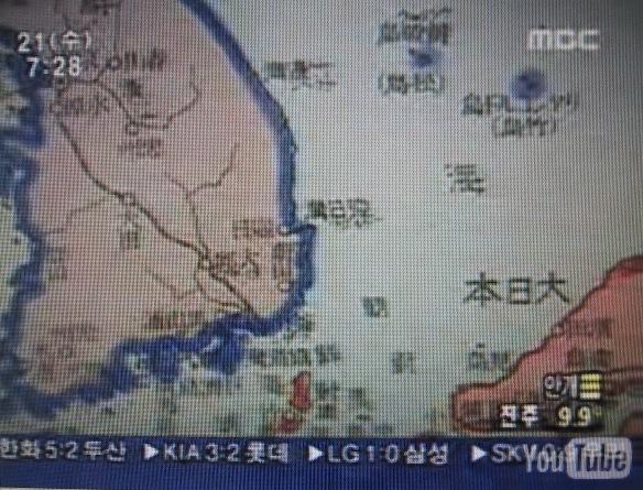
Now look at a sreenshot at 31 seconds into the video. Notice how the Japanese mainland and Tsushima have suddenly been outlined in bright orange? MBC News obviously added the orange outline to Japan.

Now, look at the following screenshop at 1:29 into the video. Notice that the Korean mainland, Ulleungdo, and Liancourt Rocks are no longer outlined in heavy bluish purple? It seems that MBC News forgot to add the outline to this photo of the map. This is more evidence that MBC News enhanced the video.
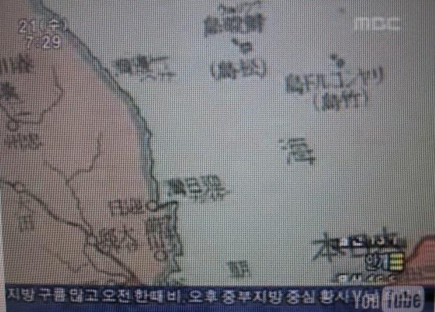
Finally, the following is a closeup of the map from another source. Notice how Ulleungdo (鬱陵島) and Liancourt Rocks (Takeshima - 竹島) do seem to have a tinge of blue on one fringe, but was that intentional or was it just bleeding from the blue lines used to indicate the water? For example, notice that there also appears to be some bleeding of blue around some of the Chinese characters on the map.

I am not sure if the map meant to show Liancourt Rocks as Korean territory or not, but if it did mean to show the rocks as Korean territory, then it was clearly an error since documents clearly prove that Japan incorporated Liancourt Rocks in 1905 and changed their name to Takeshima (竹島).
I think it was pretty silly for the Korean professor to suggest that this map should end the Dokdo-Takeshima debate. I also think it was deceitful of MBC News to alter the map to try to make their argument.
Gerry,
ReplyDeleteThanks for the interesting topic.
The textbook was published in 14th year of Showa for primary school children (尋常小学国史絵図), which was once auctioned off at Yahoo auction. (Please look at the site below.)
http://page18.auctions.yahoo.co.jp/jp/auction/w23257612
(Scroll down the site and you'll find what this textbook was like.)
The map in the video was an illustartion of the battle in the Sea of Japan in the Russo-Japanese war. Japanese fleet defeated Russian fleet at around Liancourt Rocks and the Rocks (Takeshima, or Riyankorudo-to) became famous among Japanese peolpe. (The postcard of the battle around the island sold well in those days.)
So everybody in Japan in those days knew that the island was Japanese island. And the textbook was made to encourage Japanese children during the war.
So this is obviously a fabrication. This kind of lie would be exposed easily. (A copy of the textbook will be available at auctions in the future.)
My interest is that why these people made this kind of transparent lie. Are they driven to a corner?
I searched for the textbook on Amazon Japan and found out that there was a book entitled "The examination of the textbook 尋常小学国史" which was published in 1999.
ReplyDeletehttp://www.amazon.co.jp/%E6%95%99%E7%A7%91%E6%9B%B8%E3%80%8E%E5%B0%8B%E5%B8%B8%E5%B0%8F%E5%AD%A6%E5%9B%BD%E5%8F%B2%E3%80%8F%E3%82%92%E7%A7%91%E5%AD%A6%E3%81%99%E3%82%8B-%E4%B8%AD%E8%A5%BF-%E4%B9%85%E6%B2%BB/dp/4884835662/ref=sr_1_3?ie=UTF8&s=books&qid=1213979
And there was a revised version of the textbook "尋常小学国史" (1970), which is available as used books. (But I don't know if this revised book was based on the same book published in 1939.)
Gerry,
ReplyDeleteEnjoyKorea had a photo of the map in the textbook:
http://bbs.enjoykorea.jp/tbbs/read.php?board_id=phistory&nid=106678&start_range=106669&end_range=106687
I don't know if this blue colour was originally printed or added later. But as you say, it was written as "リヤンコルド島(竹島)" in Japanese, not "Dokdo" (独島)so I think it is not so important.
One more thing, Gerry.
ReplyDeleteHere you can see the close-up of the map.
http://tawagotox.exblog.jp/711981
According to this map, "リャンコルト島(竹島)" (Ryankorudo-to (Takeshima)" doesn't look as coloured although 欝陵島 (松島)"Ulleungdo (Matsushima)" looks as coloured in blue.
Thank you for those closeups, Pacifist.
ReplyDeleteIn the map HERE, it looks like the blue around Liancourt Rocks could have just been smearing of the blue lines showing the ocean. For example, look at how the blue is also smeared between the lines in the Chinese character 島. It seems like if they had really wanted to show Liancourt Rocks as Korean territory, then they would have clearly colored the inside of the island, as well, instead of just one small side of the fringe.
Anyway, I wonder what the textbook says about Takeshima? What the textbook said about Liancourt Rocks was not mentioned in the news broadcast.
Thanks Gerry for the newly added information.
ReplyDeleteI now think that they were driven to corner. This maybe their last resort, as now that it has been proved that Usando was not Liancourt Rocks, Sambon-do was not Liancourt Rocks, and Seokdo was not Liancourt Rocks.
There is no evidence to show Korea had known Liancourt Rocks before the 20th century. It has been clear that all the mistake for Korea began with the illegal occupation of the rocks by Rhee Syngmann in the 1950's, but after half a century they lost the chance to admit that. But they should someday, or they won't be a reliable country forever.
This comment has been removed by the author.
ReplyDeleteGerry Bevers,
ReplyDeleteThis Japanese geography textbook of 1939 is a perfect evidence showing Liancourt Rocks(竹島) are Korean territory ending the Dokdo-Takeshima debate.
Is your point MBC News intentionally added the outlines of Korean Peninsula, Japanese mainland, Ulleungdo, and Liancourt Rocks? If so, you are intentionally or unknowingly misleading the readers.
Most of the YouTube videos which are uploaded by Japanese people criticizing things related to Korea are distorted like this video above.
MBC News didn't do such a malicious thing as you mislead. What MBC did was just highlighting the existing outlines of the map for emphasis by making them thicker and brighter.
The map of Japanese government textbook of 1939 is
HERE1 and HERE2 .
The full video of MBC News on 1939 Japanese-government textbook is
HERE.
The MBC news says this 1939 Japanese geography textbook was first published in 1928, which means this book had been used for 10years teaching Japanese young students Liancourt Rocks (Dokdo) were Korean land.
Pacifist,
This map and MBC News are not a fabrication. Denying your own geography textbook proves you are driven to a corner. This map is a clear evidence Japan knew Dokdo belonged to Korea before Japanese incorporation of 1905. It was a justice Japan had to return Dokdo to Korea after WW2 because Dokdo was the Korean land imperial Japan took by greed.
There are more Japanese geography textbooks which show Japan clearly recognized Dokdo was Korean land before Japanese incorporation of Dokdo.
日本地誌(1897) 1 and 日本地誌(1897) 2
初等地理書附圖(1934)1 and 初等地理書附圖(1934)2
As for that map, another interpretation is possible.
ReplyDeleteThis geography textbook of 1939 is a perfect evidence showing Quelpart Island (Jeju, 済州島) is not Korean territory.
The MBC news says this 1939 Japanese geography textbook was first published in 1928, which means this book had been used for 10years teaching Japanese young students Quelpart Island or 済州島 were not Korean land.
In fact, the kingdom of Tamna or Tamna guk ruled Quelpart Island from ancient times until it was absorbed by the Korean Joseon Dynasty in 15 century.
小嶋日向守,
ReplyDeleteHow dare you make such a nonsense comment? Jejudo was not just drawn in this map.
Anyway, you have no objection Japanese government then taught Japanese students Japan in 1905 stole Dokdo which was a Korean land?
It's a good idea as a therapist to go along with a megalomaniac once in a while.
ReplyDelete小嶋日向守,
ReplyDeleteDo you happen to refer to me as a megalomaniac? If so, don't you think I'm deserved to know why?
This comment has been removed by the author.
ReplyDelete一般日本人読者の皆さまへ
ReplyDeleteこのslowwという人物は、竹島が日本領土であることをすでに知っています。それにもかかわらず、彼は、事実を歪めて嘘をつき続けています。私はもう彼の相手をするのはやめました。
彼が主張する1939年の教科書が書かれた頃は、日本が韓国を併合して日韓の旧国境がなくなって久しい時代です。たとえ地図製作者が、鬱陵島と竹島の間にかつて存在した旧国境に注意を払わなかったとしても、そこから時代的にありえない意図を見い出そうとする行為自体が意味をなしません。この地図から、それを求めようとする者は、誇大妄想患者以外のなにものでもありません。
この妄想患者は、この地図を地理の教科書だと嘘をついています。しかし、これは地理の教科書ではありません。これは日本国史の教科書です。それも日露戦争における戦闘状況の推移を表したものです。たとえ地図の小さな島の表現が不正確であってもそれは重要ではないのです。例えば、山口県の大津島から笠戸島周辺の地理は酷く誤っています。大津島と思しき島は、形状も実際と異なっていて、色も塗られていません。常識的に言って、こんな小さな島の地図を多色刷りするのも困難ですから、多色印刷に漏れや誤りがあったとしても、重大な欠陥といえるものではありませんし、単なる印刷ミスと判断されてしかるべきものです。
http://1.bp.blogspot.com/-zIlxgRT67js/T98FiFCSdpI/AAAAAAAAAa4/xCjehVlwbBU/s1600/1939.jpg
http://2.bp.blogspot.com/-0Jb7-wGUqH8/T98JfO1Vq3I/AAAAAAAAAbE/6F511os8xZ0/s1600/1939.jpg
http://www.sportsseoul.com/news2/life/social/2008/0716/20087161544_343605876_9589_0.jpg
確かに、竹島は、朝鮮の島々と同じ青い色で塗られているように見えます。しかし、だからといって竹島を赤く塗ることが、必ずしも必要ではない時代の地図なのです。それはどういうことか示しましょう。
地図の右枠外の表題には、
日露戦争を示す、「明治三十七八年戰役」とあります。これは、期間としては、1904年2月8日 から 1905年9月5日を意味します。
1904年は閏年なので、2月8日から翌年の1月27日までは354日であり、残りの期間は221日です。竹島が、国際法的に正式に日本領土となったの1905年1月28日です。
すなわち、
354/575 国際法的には、無主地であった時期が、全期間の61.6%です。
221/575国際法的に近代日本領となった時期が、全期間の38.4%となります。
したがいまして、この歴史地図の示す575日間の過半は、国際法的に無主地であったわけですので、赤く塗らなかったことは、極めて正確な表現といえます。
さらにもっと正確を期すならば、白色で印刷するべきであったのかもしれませんが、それでは竹島が見えなくなってしまいます。これは土台から、無理な注文です。
Correction : I am deserved → I deserve
ReplyDelete小嶋日向守 ,
You gave the reason why you think I'm a megalomaniac to Japanese readers, not to me. Anyway, I figured out why I'm a megalomaniac to you, but I'm sure lots of Japanese readers are sensible enough to interpret this map correctly and disagree with you.
You wrote "Sloww already knew Takeshima was Japanese land. Nevertheless, he keeps lying." Don't mislead about me. I wouldn't be in this blog if I believed Dokdo was Japanese land. I haven't made any lie.
You said there was no national boundary between Korea and Japan when this textbook was published in 1939 because Japan annexed Korea in 1910, but unfortunately for you, the Japanese at that time didn't think the way you like to. They clearly marked Dokdo as Korean land in various maps even after Japanese annexation of Korea, let alone other parts of Korea.
If you believe the national boundary including Dokdo as Korean land is useless in the maps after Japanese annexation of Korea in 1910, what is your opinion on the maps depicting Dokdo as Korean land between 1905 and 1910? Japan incorporated Dokdo because there was no traces of occupying by other countries in 1905. It means Dokdo should had been marked as Japanese land since 1905. But in the maps after 1905, Dokdo was consistently depicted as Korean land.
You wrote "This megalomaniac is lying this map is geography textbook, but it's Japanese historical textbook." You are right. It's historical textbook, not geography textbook. I didn't do it intentionally and I think it doesn't make any difference in proving this map illustrates Dokdo as Korean land. Anyway, you are good at finding mistakes in my comments and I thank you for that.
You also said "Takeshima was surely colored in the same as Korea, but coloring Takeshima in the same as Japanese mainland was not necessary in those years..........Dokdo was ownerless (無主地) for more than half of Russo-Japanese War period, so that it is right Dokdo was not colored in the same as Japanese mainland." Your comment doesn't make any sense. If Japan truly believed Dokdo was ownerless, why was it colored in the same as Korean? You are desperately trying to deny so simple fact that the 1939 textbook map shows Dokdo belonged to Korea by coloring it in the same as Korea.
No matter how you try to discredit this map, there's no doubt this map proves Japanese illegal incorporation of Dokdo.
I found the new map especially for you which shows Japan knew Dokdo was Korean land at the time of Japanese incorporation of Dokdo and before Japanese annexation of the whole Korea.
The name of the map is "New Territory Chosun(新領土朝鮮)" published in 1910 when Japan annexed Korea.
New Territory Chosun(新領土朝鮮)1
New Territory Chosun(新領土朝鮮)2
This map clearly shows Japan considered 竹島(Dokdo) as newly acquired land along with Ulleongdo and Korean mainland in 1910. According to Japanese incorporation of Dokdo, Dokdo became Japanese new land in 1905. Then how come Dokdo was considered as new territory acquired by annexing Korea in 1910? This map is an undeniable evidence that Japan just robbed Korea of Dokdo in 1905.
Japanese claim to Dokdo is shameless. What is more shameless is Japanese schools teach Japanese students Dokdo is Japanese land. I can't help asking if Japan is truly qualified to be called as one of the leaders of the world?
New Territory Chosun 에 쓰고 있는 한자 이름은 다케사마 밖에 없는데요
ReplyDelete어디에 竹島(Dokdo)라고 쓰고 있어요?
일본은 제3자 이름Liancourt Rocks 를 1905년에 일본 땅 됐다
ReplyDeleteNew Territory Chosun는 1910년이죠
거기에 다케시마 라고 쓰고 있으니
일본 땅이죠
끝
shima take,
ReplyDelete제가 竹島(Dokdo)라고 적혀있다고는 안 했는데요.
다케시마가 한자이름인가요? 일본이름이지.
다케시마의 한자이름은 竹島죠.
竹島는 한국에서는 독도(Dokdo)라고 하죠.
Liancourt Rocks가 1905년에 다케시마(竹島)가 된 것 아시죠?
1905년에 일본땅이 된 竹島가 왜 1910년 조선지도에 들어가 신영토가 됐나구요.
즉, 일본이 1905년에 조선땅인 다케시마(竹島)를 슬쩍 했다는것을 이 지도를 통해 스스로 인정한 것입니다.
저도 끝
sloww가 적었냐고 안 물어 봤는데요
ReplyDelete>다케시마가 한자이름인가요? 일본이름이지.
다케시마의 한자이름은 竹島죠.
New Territory Chosun를 봤어요?
거기에 한자로 다케사마 밖에 없는데요
어디에 독도 라고 적어 있어요?
>竹島는 한국에서는 독도(Dokdo)라고 하죠
그건 sloww(1950년부터 사용가능) 의견이잖아요.
1.지도를 뭐라고 적어 있는지 물어요
대답을 해 주세요.지도에요 지도
지도에는 일본 영토도 있는데요 외국인 봤을 때 sloww 주장를 쓴다면 일본도 조선 땅 되는데요
대마도도 작게 볼 수 있는데요
제가 아는 한국인 학생 한테 물어보니 먼제 지도에 적어 있는 일본어를 설면을 달라고 했는데요 그리고 밑 질문 해요
2.어디에 울릉도는 조선 땅 다케시마가 일본 땅 아니면 조선 땅이란 확실한 설면 있어요?지도 위 밑에 있는 한자로 그렇게 적어 있을까요?
sloww가 오해하고 있어요?청국도 있고 일본 영토도 있는데 혹시 New Territory Chosun 라고 적고 다케시마를 적어 안 된다는 법이나 그런 거 있어요?
>1905년에 일본땅이 된 竹島가 왜 1910년 조선지도에 들어가 신영토가 됐나구요
ReplyDelete들어간다고 아니라 적어 있어요
제가 자꾸 적어 있냐고 물어보니 sloww는 적어 있다고 대답을 하죠?
sloww가 쓴 (들어가다)이라고 뜻은 조선 땅에 들어간다는 뜻이죠 왜 들어간다는 말을 쓰는 것이 궁금해요 왜요?적어 있는 것이랑 들어가는 것 객관적인 차이 뭐에요?
만약에 저한테 물어보니 이렇게 객관적 대답을해요
일본은 제3자 이름Liancourt Rocks 를 1905년에 일본 땅 됐다
New Territory Chosun는 1910년이죠
거기에 다케시마 라고 쓰고 있으니
일본 땅이죠
끝
shima take,
ReplyDelete거기에 한자로 다케시마 밖에 없는데요
어디에 독도 라고 적어 있어요?
→제가 독도라고 적혀있다고 했나요? 竹島는 Dokdo를 가르킨다는 것이죠.지도에 없는 Dokdo를 제가 적었을때는 竹島의 한국이름이라는 것을 아는 사람은 압니다.
竹島는 한국에서는 독도(Dokdo)라고 하죠
그건 sloww(1950년부터 사용가능) 의견이잖아요.
→ 그럼 독도를 독도라고 하지 뭐라고 합니까?
지도에는 일본 영토도 있는데요
→일본영토가 일본의 신영토인가요?
어디에 울릉도는 조선 땅 다케시마가 일본 땅 아니면 조선 땅이란 확실한 설면 있어요?
→제목을 보면 알죠.
청국도 있고 일본 영토도 있는데 혹시 New Territory Chosun 라고 적고 다케시마를 적어 안 된다는 법이나 그런 거 있어요?
→그런 법이란게 어디 있겠어요. New Territory Chosun에 Takeshima가 있으니 Takeshima는 일본의 신영토라는거죠.
New Territory Chosun는 1910년이죠
거기에 다케시마 라고 쓰고 있으니일본 땅이죠
→무슨 말인지 이해가 잘 안 가지만, 다케시마라고 적혀있으면 일본땅이란 말인가요?
다케시마로 적혀있지만 한국땅으로 표시한 일본지도 있습니다.1939년 교과서 지도에도 다케시마라고 적혀있지만 한국땅으로 표시하고 있네요.
This comment has been removed by the author.
ReplyDeleteThis comment has been removed by the author.
ReplyDelete製作者さんへ
ReplyDelete英語は苦手なので詳しくいえませんが、この本は国定教科書ではありません。島根県のおよび日本政府の見解はこちらにあります
http://www.pref.shimane.lg.jp/soumu/web-takeshima/takeshima08/2007/record200807.html
英語で書いてあるなら良いですが、一応書いておいたほうがいいのかな?よろしくお願いします
>제가 독도라고 적혀있다고 했나요?
ReplyDeletesloww가 적었냐고 안 물어 봤는데요
거기에 한자로 다케시마 밖에 없는데요.어디에 독도 라고 적어 있어요?
>竹島는 Dokdo를 가르킨다는 것이죠.지도에 없는 Dokdo를 제가 적었을때는 竹島의 한국이름이라는 것을 아는 사람은 압니다.
위에 있는 질문인데요 대답을 주세요
>그럼 독도를 독도라고 하지 뭐라고 합니까?
그 때 시대를 사용한다면 석도 아니었을까요.그 전은 우산도
http://yeoksa.blog.fc2.com/blog-entry-504.html
>일본영토가 일본의 신영토인가요?
어디까지 일본 영토인가요? 일본은 1905년 다케시마도 일본 영토인데요
다케시마는 일본 영토니까 일본땅이죠 1905년에 일본 땅 되었으니. 즉 sloww도 다케시마는 일본 땅이고 인정하고 있잖아요.
왜 일본 영토(1905년다케시마 포함)가 일본 땅 아니고 다케시마는 일본 영토 아니라고 생각하는지 궁금해요
>제목을 보면 알죠.
제목은 New Territory Chosun 新領土 朝鮮 신영토 조선 sloww가 쓴대로요.
제목은 New Chosun Territory 新 朝鮮領土 신 조선영토 아니에요.
일본 시점을 보면 1905년 다케시마는 일본 땅이고 일본 영토 . 조선을 보자고 하는 지도죠
그리고 위를 보면 한국 병합이니 이걸 주오(일본) 신영토를 가진 조선이란 뜻이 되고 월래 조선 땅은 이것이다 란 주어는 없어요.
그리고 다케시마는 1905년부터 일본 땅이고 일본 영토.아까 sloww도 일본 땅이라고 인정하죠..
>그런 법이란게 어디 있겠어요.
질문에 대답을 주세요 . 지도에 쓰고 있으니 일본 땅 아니면 조선 땅이란 법이나 있어요?
Territory Chosun 대마도도 작게 있는데 왜 다케시마만 조선 땅인가요. 대마도는 일본인 살고 있고 다케시마는 1905년 법으로 일본 땅이 되었어요 즉 일본 땅 주장으로 썼죠
sloww도 인정하고 있는 일본 영토(1905년 다케시마도 포함)는 신 영토?아니에요.월래 일본땅이죠
>New Territory Chosun에 Takeshima가 있으니 Takeshima는 일본의 신영토라는거죠.
그 주장이면 저번 적었는데 일본 영토 적어 있고 청국도 적어 있어요. 조선 땅?
들어가다는 근거는 법은 1905년에 법으로 일본은 다케시마를 일본 땅이 되었어요
>다케시마로 적혀있지만 한국땅으로 표시한 일본지도 있습니다.1939년 교과서 지도에도 다케시마라고 적혀있지만 한국땅으로 표시하고 있네요.
1939년 이거 국정교과서 아니에요
다시 적어요
만약에 저한테 물어보니 이렇게 객관적 대답을해요
일본은 제3자 이름Liancourt Rocks 를 1905년에 일본 땅 됐다/일본 영토는 다케시마도 포함
New Territory Chosun는 1910년이죠
거기에 다케시마 라고 쓰고 있으니
일본 땅이죠
끝
This comment has been removed by the author.
ReplyDeleteshima take,
ReplyDelete"New Territory Chosun"에 다케시마 라고 쓰고 있으니 일본땅이라는 주장, 좋습니다. 지도해석은 입장에 따라 달라질 수 있으니까요.
그러면, 다음 지도에 있는 다케시마도 일본땅이라고 하실지 궁금하군요.
日本海大海戰圖 1
日本海大海戰圖 2
sloww
ReplyDelete대답 주세요