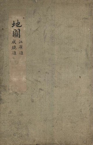
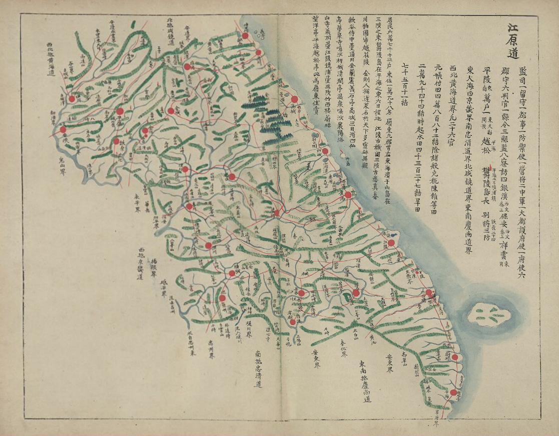
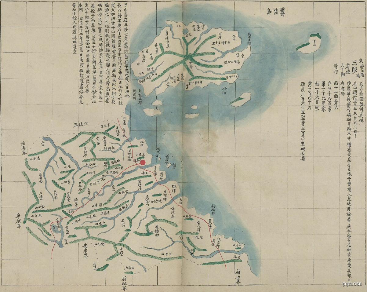
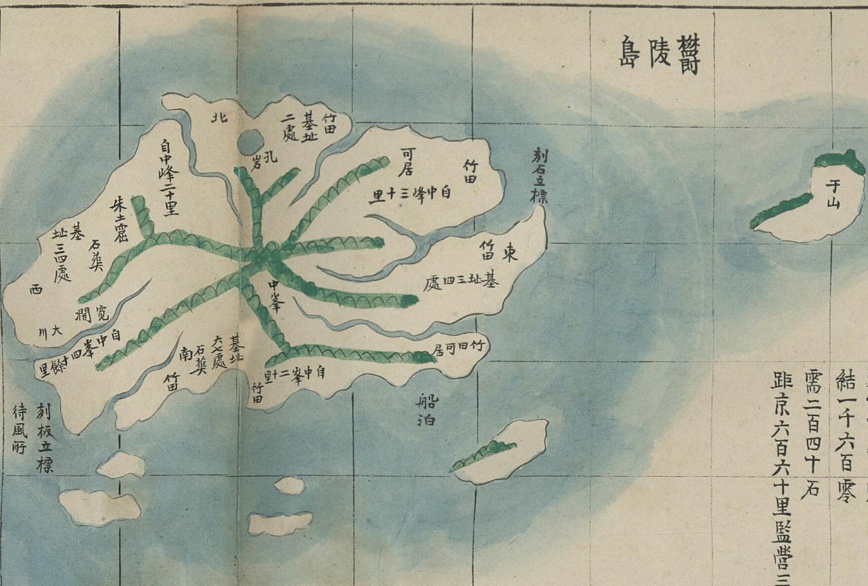
 Below are maps of Gangwon Province (江原道) and Samcheok Dohobu (三陟都護府), which includes a map of of Ulleungdo (鬱陵島). Off the east shore of Ulleungdo is an island labeled as "Usan" (于山), which was almost certainly Ulleungdo's neighboring island of Jukdo (竹島). Jukdo is about 2.2 kilometers off the east shore of Ulleungdo. The maps come from the Korean atlas pictured on the left, which is stored in the Koryo University Library.
The Koryo University Web site says the atlas was made sometime between 1835 and 1894, but I think it can easily be dated between 1884 and 1894.
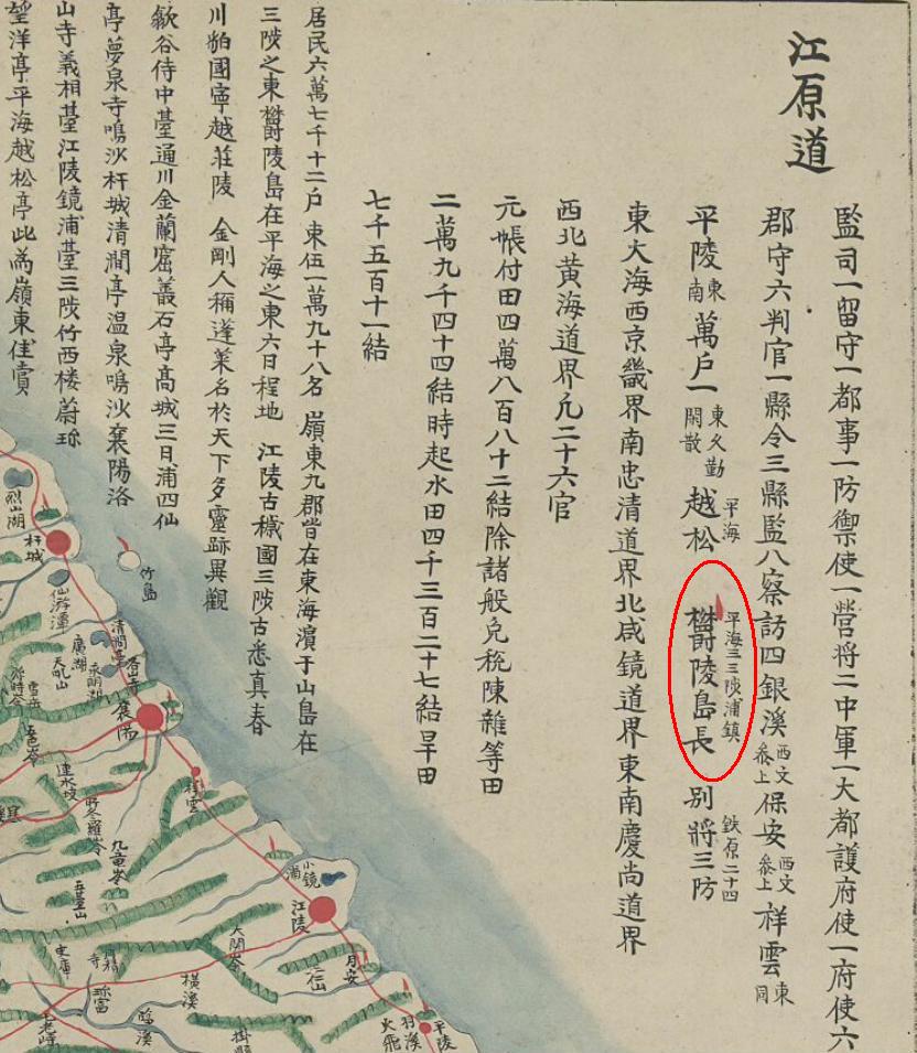
If you look at the Gangwon Province map below, you will see a list of Gangwon Province official titles on the map. Among the officials listed was the "Ulleungdo-jang" (鬱陵島長 - Ulleungdo Chief), which I have circled in red. Next to it was written "Pyeonghae, Samcheok-po Jin" (平海三三陟浦鎭). This is the clue to the date of the map since the position of "Ulleungdo-jang" was not established until 1883. Moveover, we may be able to pinpoint the date even closer based on the fact that "Pyonghae" (平海) and "Samcheok-po Jin" (三陟浦鎭) were written next to "Ulleungdo-Jang," which suggests that the Ulleungdo-Jang came from Samcheok-po Jin.
In 1884, the duties of Ulleungdo-Jang was transferred from low ranking officials dispatched to Ulleungdo to the Samcheok Commander (三陟營將) and then to the "Pyeonghae County Head" (平海郡守). However, during this time the title of "Ulleungdo-Jang" (鬱陵島長) was changed to "Ulleungdo-Cheomsa" (鬱陵島僉使). The title of Ulleungdo-Jang (鬱陵島長) was not reestablished until 1888, when the duties were handed over to the "Manho" (萬戶) at Weolsong-jin (越松鎭), which was in Pyeonghae County (平海郡). The position of "Ulleungdo-Jang" (鬱陵島長) continued until 1895, when it was upgraded to "Ulleungdo-Gam" (鬱陵島監 - Island Supervisor). That means the map would have had to been made sometime between 1884 and 1895.
Based on the fact that "Samcheok-po Jin" (三陟浦鎭), instead of "Weolsong-jin" (越松鎭), was written next to "Ulleungdo-Jang" (鬱陵島長), and on the fact that the map appears with a map of Samcheok Dohobu (三陟都護府), the map seems to have been made between 1884 and 1888. Even though the official title during that time period was "Ulleungdo-Cheomsa" (鬱陵島僉使), "Ulleungdo-Jang" (鬱陵島長) could have still been used as an unofficial title, or the mapmaker could have just made a mistake and used the old title. At any rate, the map was made after 1884.
The significance of this map is that it shows Ulleungdo with a neighboring island labeled as Usan (于山) rather than the Jukdo (竹島) that Lee Gyu-won found during his inspection in 1882. That suggests that inspectors discovered that the neighboring island was being called both Jukdo and Usando. It also means that this was the last Korean map of Ulleungdo, which is still known to still exist, to have been made before Korea's 1900 Imperial Edict 41, which made the main island of Ulleungdo (鬱陵島) and its neighboring islands of Jukdo (竹島) and Seokdo (石島) a county of Gangwon Province.
Now I agree on your great findings.I had only care about Ulluengdo plus Uljin map but I didn't check the 江原道 map.
ReplyDeleteIt is very mistery that they draw the childish ullunegdo map like this, as if it referenced from 1750's 朝鮮地圖, although other inspectors reports very precize maps like below;
Detail map of Ulluengdo 鬱陵島圖形 1711
Two maps maybe Early-middle 18th century?
Detail map of Ulluengdo 鬱陵島圖形 in Samchok museum
Detail map of Ulleugndo 鬱陵島圖形 in Korea national library
Detail map of Ulluengdo 鬱陵島外圖 1882.
Detail map of Ulluengdo by 赤塚正輔(Japanese) 1900.
Good morning, GTOMR.
ReplyDeleteActually, I do not think the map is that childish since it does use gridlines to show relative distances. Also, those gridlines and the shape of Ulleungdo make me wonder how Seoul National University dated THIS MAP, which is believed to have been made sometime between 1750 and 1768.
Maybe, someone should go back and reevaluate some of these maps?
GTOMR & Kaneganese,
ReplyDeleteActually, this map is a little confusing for me since the name 越松 (Weolsong) comes just before 鬱陵島長 (Ulleungdo-Jang) on the map, which suggests that the Ulleungdo-Jang was from Weolsong. If that is true, then the map should be dated from 1888 to 1894.
I am not exactly sure how to interpret all the writing, so I think more study is needed.
Gerry,
ReplyDeleteThanks for the interesting map.
BTW, I found this site which contains various maps:
http://www16.tok2.com/home/otakeshimaoxdokdox/UllunegoMapsDiscography/19C%201801-1870's.htm
I especially interested in the "1859-65.19C中期 東輿 鬱陵島 (写本)" which Korean National Central Museum (韓国国立中央博物館) owns.
It also has gridline but the picture is somewhat blurred.
Gerry,
ReplyDeleteI noticed that Aki stated about Chosen Yochizu (Map of Chosun, 1894) in his/her own blog:
http://aki-akiaki.blogspot.com/2008/03/kim-okgyuns-korean-map-published-in.html
Tha map was made in Japan but the information was brought by Kim Okgyun (金玉均, 김옥균), the Korean reformist. The map showed the Argonaut island as Takeshima and Ullengdo (Dagelet) as Matsushima. There is no mentioning of Liancourt rocks. So this map means that one of the intellectual Koreans in those days who once worked in Ulleungdo didn't know about Liancourt rocks.
Hi Pacifist,
ReplyDeleteKim Ok-gyun was not only a Korean intellectual; he was the man in charge of moving settlers to Ulleungdo until he had to flee Korea in 1884, which means he should have known better than anyone the situation on Ulleungdo in 1884. And since his map did not show Liancourt Rocks, we can assume that he either did not know of the rocks or did not consider them to be a part of Korean territory.
Yes, I read Aki's post, which was very good.
Gerry,
ReplyDeleteI found the following site with some interesting maps:
http://www.cartography.henny-savenije.pe.kr/quality/index.htm
For example, the 1865 map which was made in Paris indicated Ousan precisely just next to Ulleungdo.
http://www.cartography.henny-savenije.pe.kr/quality/pages/missionair_jpg.htm
Gerry,
ReplyDeleteI saw some German-made maps of Korea which were made in 1892, 1894 & 1897.
The last map can be seen here:
http://cgi.ebay.com/JAPAN-KOREA-Taiwan-Liancourt-Curil-Islands-Map-1897_W0QQitemZ270195818243QQihZ017QQcategoryZ37960QQrdZ1QQssPageNameZWD1VQQcmdZViewItemQQ_trksidZp1638Q2em118Q2el1247#ebayphotohosting
All these maps are very accurate, as they show Ulleungdo as "Matsushima (Dagelet I.)" and Liancourt rocks as "Liancourt Rocks (Hornet rocks)", and they don't include the ghost island of Argonaut.
Additionally, all these maps coloured both "Matsushima (Dagelet I)" and "Liancourt rocks (Hornet rocks)" as the same colour as Japan.
It seems that western countries in those days recognised as Ulleungdo as Japanese territory, although this was not true, but which may mean that there is no chance for Korea to claim that Liancourt rocks to be their territory.
P.S. I got a few of these maps from e-Bay recently.
Interesting maps, Pacifist. I have bookmarked that page.
ReplyDeleteI think we have already talked about one of the maps HERE.
By the way, did you see the maps on the link that Kaneganese told us about HERE?
Gerry,
ReplyDeleteYes, I saw some of the maps in the site (of Alabama Univ) and noticed that although American maps usually conveyed Argonaut I (as Take I.) until early 20th century (1902-1903), German maps (printed in Leipzig) excluded Argonaut I even in 1890's.
P.S. Some maps can be seen too in the following Texas site, although not so many.
http://www.lib.utexas.edu/maps/middle_east_and_asia/
To follow is American-made map of Korea. It doesn't include Liancourt rocks, although it includes Ulleungdo.
http://www.lib.utexas.edu/maps/middle_east_and_asia/s_korea_pol_95.jpg
Gerry,
ReplyDelete"I am not exactly sure how to interpret all the writing, so I think more study is needed."
I couldn't really understand what you are trying to say (Sorry...), but if you are not so sure about the year when the map was made right now, maybe the title sould be written as "1884 - 1888 ? .... " in order to avoid any confusion for the readers at least until you become sure about it? I think it would be more friendly to the readers. Not everyone read comment section. But posting your ideas and findings itself is great since it would give us a chance to study more about the map, and hopefully, someone gives us more information about it.
Good idea, Kaneganese, but I think I will put "1884 - 1994" without a question mark since I am pretty sure of that date.
ReplyDeleteAnyway, what I was trying to say was that if the "Ulleungdo-Jang" (鬱陵島長) was the "Manho" (萬戶) out of Weolsong-jin (越松鎭), then that would mean the map could be dated between 1888 and 1895 since that was the time the Weolsong-jin Manho was Ulleungdo-Jang.
Between 1884 and 1888, the Camp Commander at Samcheok replaced the Ulleungdo-Jang, but was called "Ulleungdo Cheomsa," instead.
If you look at the writing on the map, you will see that "Weolsong" (越松) is written just before, which would suggest he was out of Weolsong, but in small letters next to "Ulleungdo-Jang" (鬱陵島長) is written "Pyeonghae, Samcheok-po Jin" (平海三三陟浦鎭), which suggests he was out of Samcheok-po Jin. Do you see my confusion now?
The fact that Ulleungdo appeared on the Samcheok map makes me believe that the map was made when the Ulleungdo-Jang was the Samcheok commander, which was between 1884 and 1888. The only problem with that is that he was not called "Ulleungdo-Jang," but was called "Ulleungdo Cheomsa." However, I am thinking that "Ulleungdo-Jang" could have been his unofficial title since he replace the previous Ulleungdo-Jang.
Yes, I know it is a little confusing.
At any rate, I think we can safely say the map was made between 1884 and 1894. I stopped it at 1894, instead of 1895, because that was the upper limit for the map given by Koryo University, who probably had a good reason for dating it up to 1894.
So, I think this means this was the last Korean map of Ulleungdo made before the 1900 Imperial Edict that made Ulleungdo and her neighboring islands a county of Gangwon Province. Of course, it is possible that U Yong-jeong (禹用鼎) made a map of Ulleungdo that we do not know about since he inspected the island in 1900, before the edict was proclaimed.
Thanks, Gerry
ReplyDeleteI got it finally. Besides, as long as "鬱陵島長" is listed, it is highly unlikely to be made 1700's, in the first place, right?
"I think I will put "1884 - 1994" without a question mark since I am pretty sure of that date."
You mean "1884 - 1894" ? As long as you are sure about it, yes, it's good. Anyway, good find, Gerry. By the way, isn't it possible to send some question to Koryo University to ask how they defined the year of the map was made, like Shimane prefecture site?
I'm not sure if this non-official map has anything to do with 1900 Imperial Edict or not, but the text on the map does include some new information on Usando and Ulleungdo, so it is a very important for us. I really hope Korean make all the documents 禹用鼎 supposed to submit to Korean government public.
Kaneganese,
ReplyDeleteYes, I meant 1884 to 1894. Sorry.
If Koryo University dated the map between 1835 and 1894, then that means they do not know the date of the map.
Korean maps are usually dated by the name change of some village or mountain that is recorded in Korean records. If the map reflects that change, or does not reflect it, then scholars can use that to narrow down the date of Korean maps. In the case of this map, the person looking at it obviously overlooked the mention of "Ulleungdo-Jang" (鬱陵島長) because that is a clear indicator that the map was made after 1883.
I guess there is someone at Koryo University who may know about this map, but I think we now know more about it than he or she does. Even the Dokdo Museum could only date this map to the mid-1800s. I do not know if they overlooked it, or if they did it intentionally to give the impression that it was made before Lee Gyu-won's 1882 inspection, but that is the date mentioned on their Web site.
I do not know how to distinguish official Korean maps from unofficial, but Koreans seem to have been pretty sloppy in recording details about their maps. For example, few of Korea's old maps had dates on them, which forces Korean scholars to try to guess the dates. The 1711 map is one of the few exceptions, but the Samcheok Museum map and the other inspector's map in the Korean National Library are undated.
この地図と同じデザインと考えられるものに、
ReplyDelete1895.12月20日の、輿載撮要.江原道(韓国中央図書館古朝60-20)があります。
同様に、于島が鬱陵島の北東部にあり、かつ、南の五島が記載されています。
この後に、この図柄を踏襲・簡略化したと考えられる例の朝鮮地図(1898)・大韓全図(1899)・大韓輿地図(1900頃?)が続きます。(ただし、大韓全図は南四島)
(matsu様情報提供ありがとうございます)
Very interesting map, GTOMR. Can you give me more information on it?
ReplyDeleteGTOMR,
ReplyDeleteI found some information on it, but I would appreciate anything else you might know about the map.
Link
I checked 輿載撮要 on Korea national digital library and found three version. one and three version is almost same, but second one (year unknown?) have different and it is complete set of 輿載撮要?
ReplyDelete1/3 and 2 have diffferent attached maps like this.
http://seaofjapan-noeastsea.blogspot.com/2010/10/1887.html
地圖(1884-94c.a.)と輿載撮要の鬱陵島の記述の記載の違い
ReplyDeleteThe difference of description of Ulluengdo between Jido and 輿載撮要
”地圖(1884-94c.a.)に記載の鬱陵島の記述
The description of Ulluengdo on Jido地圖(1884-94c.a.)
于山島在三陟の東鬱陵島在平海ノ東六日程地
長百余里廣六十里四面石角嵯峨多寺刹古址竹大如桃
鼠大如猫古于山國新羅智?王時異斯夫以木獅子載
船?之日不眼即放此数踏???之国人惧乃降高麗崔
?欲移民以實之風涛険悪末果 自中峯東至海一
萬余歩西至海一萬三千余歩南至海一萬五千余北
至八千余歩有村落基址七処然多巌石民不居
本朝 世宗二十二年遣萬戸南X往捜捕畫俘金九
等七十余人而還其地遂空
The description of Ulluengdo on 輿載撮要
(XXX)=no description on ”地圖(1884-94c.a.)
【 】=there are description on ”地圖(1884-94c.a.), but not written on 輿載撮要
鬱陵島 于山島在三陟之東鬱陵島在平海ノ東六日程地
長百余里廣六十里四面石角嵯峨多寺刹古址(土壌膏沃多珍水海)竹大如椽
鼠大如猫(桃?大?凡物?是)古于山國新羅智?王時(特険不服十二年)異斯夫(為何?羅
州軍主謂于山國人愚X難以威眠乃)以木獅子載
船?之日不眼則放此数踏殺??之国人恐)乃降高麗崔
?欲移民以實之風涛険悪末果 【Not found:自中峯東至海一
萬余歩西至海一萬三千余歩南至海一萬五千余北
至八千余歩】有村落基址七処然多巌石(不知何代人)【Not found:民不】居
本朝 世宗【Not found二十二年】遣萬戸南X往捜捕(民)畫俘金九
等七十余人而還其地遂空(今) 上朝開拓許民使越松萬戸為島長
地圖記載鬱陵島記述 不明文字等加筆
ReplyDelete于山島在三陟之東鬱陵島在平海之東六日程地
長百余里廣六十里四面石角嵯峨多寺刹古址竹大如椽
鼠大如猫古于山國新羅智登王時異斯夫以木獅子載
船誑之日不服則放此獣踏殺之国人惧乃降高麗崔
瑀欲移民以實之風濤険悪末果 自中峯東至海一
萬余歩西至海一萬三千余歩南至海一萬五千余北
至八千余歩有村落基址七所然多巌石民不居
本朝 世宗二十二年遣萬戸南顥徃捜逋盡俘金九
等七十余人而還其地遂空
2010.11.06