 In 1906, one of the leading organizations of Patriotic Enlightenment Movement for the restoration of the sovereign right of the nation, “the Korean Self-Strengthening Society (大韓自强會)”, was founded by Jang Ji-yun(張志淵) and others. They published 13 edition of monthly magazines from July 1906 to July 1907. Interestingly, the front pages of those magazines are same and features Korean territory in red, blotting out Takeshima/Dokdo from her territory.
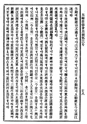
Moreover, the chapter of the Korean geography printed in the 3rd edition of the magazine published on July, 1906, clearly states that the eastern limit of Korean territory is 130º 35' E. longitude.
Remember that Jang Ji-yun was the president, the publisher and the editor in chief of Hwangseong Shinmun(皇城新聞). Its May 9 1906 article reported that 1906, Mar. 25, Uldo Prefect Governor Shim Hung-taek(沈興澤) reported that Japanese incorporated “Dokdo(獨島)” (note that he didn’t report Seokdo/石島) which locate "外洋百里(40km far in the open sea). And in a July 13, 1906 article clarified that the Korean government in 1906 did not recognize "Dokdo" (Liancourt Rocks) as being part of Uldo County (Ulleungdo), even though the government had just recently gotten a report on "Dokdo" from Shim.
This coincide with this Korean Self-Strengthening Society’s monthly magazine cover illustration of Korean Territory. It is crystal clear that Korean didn’t recognize Takeshima/Dokdo as its territory, at the time Korean got to know Japan’s incorporation in 1906. Apparently, Shim’s report was mistake and “獨島” was not “石島”, which today’s Korean claim as another name of Dokdo back then. In conclusion, 石島 in 1900’s Korean Imperial Edict No.41 (大韓勅令第41号) was not Japan’s Takeshima and Korean didn’t recognize Takeshima as its territory based on Korea’s own historical documents.
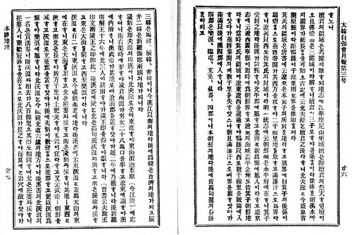
In 1907, Jang published "New Topography of Great Korea(大韓新地誌)". Its chapter of "location" states that Korea's eastern border is Tumen River and it is 130º 58' E. longitude. As for Ulleungdo, Jan wrote, that Uleung Island locates from 130º 45' N. to (130º) 35' N. and from 37º 34' E. to (37º) 31' E. (Probably the mistake for 130º 45' E. to (130º) 53' E. and from 37º 34' N. to (37º) 31' N. ) The states that Uleung island can be seen (from Korean peninsula) on a clear fine day. It also says that Usando exists to the south-east of the island. However, the map attached to the book also blotted out Takeshima/Dokdo from its "The Map of Korea(大韓全図)" and "The Map of Gyeongsangbuk-do(慶尚北道)" as well. On top of that, "The Map of Gyeongsangbuk-do(慶尚北道)" depicts Jukdo(竹島, not Japan's Takeshima) precisely on the location of Jukdo. From those historical documents, whatever the Usando Jan added really was, it is apparent that he considered Korea's easternmost was Ulleungdo and today's Takeshima/Dokdo was outside of Korean territory.
"The attatched map of The New Topography of the Great Korea (大韓新地志附地圖)" (The National Library of Korea's site)
I made some grammatical mistakes and changed from "the owner of Hwangseong Shinmun(皇城新聞)" to "the editor in chief of Hwangseong Shinmun(皇城新聞)".
ReplyDeleteI also tried to add more information about Jan, but I couldn't upload them since they were too long? Since when it was limited to 200 words? 200 words are too short...
Anyway, the below was I tried to add a while ago.
In 1907, Jan published "New Topography of Great Korea(大韓新地誌)". Its chapter of "location" states that Korea's eastern border is Tumen River and it is 130º 58' E. longitude. As for Ulleungdo, Jan wrote, that Uleung Island locates from 130º 45' N. to (130º) 35' N. and from 37º 34' E. to (37º) 31' E. (Probably the mistake for 130º 45' E. to (130º) 53' E. and from 37º 34' N. to (37º) 31' N. ) The states that Uleung island can be seen (from Korean peninsula) on a clear fine day. It also says that Usando exists to the south-east of the island. However, the map attached to the book also blotted out Takeshima/Dokdo from its "The Map of Korea(大韓全図)" and "The Map of Gyeongsangbuk-do(慶尚北道)" as well. On top of that, "The Map of Gyeongsangbuk-do(慶尚北道)" depicts Jukdo(竹島, not Japan's Takeshima) precisely on the location of Jukdo. From those historical documents, whatever the Usando Jan added really was, it is apparent that he considered Korea's easternmost was Ulleungdo and today's Takeshima/Dokdo was outside of Korean territory.
"The attatched map of The New Topography of the Great Korea (大韓新地志附地圖)" (The National Library of Korea's site)
http://www.dlibrary.go.kr/Map/main.jsp?code=KOL000021224
I corrected 張's name from Jan → Jang. Thanks, matsu.
ReplyDeleteAnd finally, I succeeded in adding last part.
On July 9 Shimane Prefectural Assembly passed a bill to submit a written statement to demand the Japanese government to bring a lawsuit against Korea's illegal occupation of Takeshima to the International Court of Justice.
ReplyDelete7月9日、島根県議会は韓国による竹島の占拠を国際司法裁判所に提訴するよう国に求める意見書を可決しました。
(竹島問題提訴求める意見書 - NHK島根県のニュース <http://www.nhk.or.jp/lnews/matsue/4034074031.html>)
Thanks for the information, unknown.
ReplyDeleteAs we have seen in Okinawa, local people must raise their voices for what they want, or the central government ignore ostrich and tend to choose principle of peace-at-any-price.
これも「日本海」と書いてありますね。
ReplyDeleteThis magazine, author write "the Sea of Japan" although it is Korean Self-Strengthening Society.
日本海記載のほかの文献:
https://sites.google.com/site/japanseamerdujapon/Home/korean-use-the-name-of-sea-of-japan-i