Three of the maps in the Dongyeo Bigo show us how the name for the Korean island of Ulleungdo evolved from "Usando" (羽山島) during Korea's Three Han Period (before 300 A.D.), to "Usanguk" (羽山國) during Korea's Three Kingdoms period, and to Muleungdo/Usan (武陵島/于散) during the early Joseon period. One of the maps even appears to show Ulleungdo's neighboring island of Jukdo labeled as "Ulleungdo" (鬱陵島). Here are the three maps from the Dongyeo Bigo:
"Boundaries during Han's 4 Gun-2 Bu Period" (四郡二府漢時分界之圖)

The above map showed the boundaries of the Korean pennisula around the time of Korea' s Three Han Period (三韓時代), which ended about 300 A.D. The map shows Ulleungdo labeled as "Usando" (羽山島).
Map of Original Regions of Silla, Goguryeo, & Baeje (新羅高勾麗百濟肇造區域之圖)

The above map shows the Korean peninsula during Korea's Three Kingdoms Period, which ended in 668 A.D. The map showsUlleungdo labeled as "Usanguk, now Ulleungdo" (羽山國 今欝陵島), which means Ulleungdo went from being called "Usando" (羽山島) to Usanguk (羽山國).
"Map of the Counties of Gangwondo's East-West Regions - Uljin" (江原道東西州郡棇圖 - 蔚珎)
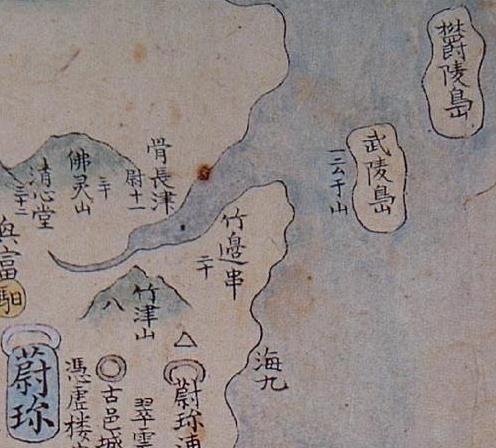
The above map shows two islands of the coast of Uljin (蔚珎). One island is labeled "Ulleungdo" (欝陵島) and the other is labeled Muleungdo (武陵島), with the phrase "also called 'Usan'" (一云 于山) written beside it.
In the 1400s, Ulleungdo was referred to as "Muleungdo" (武陵島), "Usando" (于山島), and Usan-Muleung (于山武陵). Muleungdo (武陵島) was also used to refer to Ulleungdo's neighboring island of Jukdo (竹島), which is only two kilometers off Ulleungdo's northeast shore. In the 1500s and 1600s, Korean maps showed Ulleungdo labeled as Usando (于山島) and its neighboring island of Jukdo (竹島) labeled as "Ulleungdo" (鬱陵島), though this was probably just confusion about which side of Ulleungdo the neighboring island was. By the end of the 1600s, however, the confusion seemed to have been cleared up because the main island of Ulleungdo was being labeled "Ulleungdo" (鬱陵島) and its neighboring island of Jukdo was being labeled "Usando" (于山島).
The fact that the above map shows both "Ulleungdo" (欝陵島) and "Muleungdo" (武陵島) suggests that it may have represented a time around the start of the 1500s, which was about the time the name "Muleungdo" switched back over to "Ulleungdo." The fact that the map shows the island to the west labeled "Muleungdo/Usan" (武陵島/于山) and the island to the northeast labeled "Ulleungdo" (欝陵島) suggests that, at the time the map was made, Ulleungdo was being referred to as both "Muleungdo" and "Usan" while its neighboring island of Jukdo was being referred to as "Ulleungdo." However, since the "Three Kingdoms Period" map had the phrase "Now called Ulleungdo" next to "Usanguk," we can assume that "Muleungdo/Usan" was referring to Ulleungdo's neighboring island, even though the map showed it to the west of Ulleungdo instead of the east. Nevertheless, the map suggests that Ulleungdo's neighboring island was referred to as both "Usando" and "Muleungdo" during the 1400s. By 1530, the name "Muleungdo" was replaced by "Ulleungdo," based on the following 1530 Korean map, which shows two islands beside each other. The one closer to the Korean coast was labeled "Usando" (于山島), and the one to its east labeled "Ulleungdo" (鬱陵島). The 1530 map below was not part of the Dongyeo Bigo.

Thanks Gerry, these are interesting maps which may prove that Usando was not Dokdo but Ulleungdo.
ReplyDeleteInteresting maps.
ReplyDeleteThese two maps show the transformation of the names of Ulleungdo. Originally, Usan was the name of the area around today's Ulleungdo and Usanguk was the name for the Country of Ulleungdo. Usando was for the name of the main island, but in 1400s, inhabitable small island near the main island was reported to the central government and the name of the Mulleun(Ulleung) was emerged. Later, those two names, Usan and Ulleung, were used for one island, Ulleungdo, but still remained as separate two islands as well. This confusion came from the existence of the small neighbouring island Jukdo. Jukdo locates only 2-4km east to Ulleungdo and the island seems to be uninhabitant, though it is inhabitable in fact. In 1694, inspector Jan found Jukdo and it was identified as Usando since then. In the mid 1800s, 金正浩 concluded that Ulleungdo and Usando is two names for one island, and he dropped Usando from his famous atlas "大東輿地図".
Korean lost Usando briefly again until the end of 1800s, when it was re-emerged as the biggest island of the 5-6 neighbouring islands of Ulleungdo.
In either way, Usando had never been Takeshima/Liancourt Rocks/Dokdo ever.