竹島問題の歴史

27.2.08

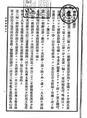
1894 - 海軍省水路部「朝鮮水路誌」(明治二十七年)

日本海軍水路部が刊行したこの本は、英国海軍発行のChina Sea Pilot(Directory) を基本とし、独自の情報も斟酌して編集されました。この本の中で特筆すべきは、冒頭、第一編 総記において朝鮮国の東限が東経130度35分とされており、東経131度55分にある現竹島/Liancourt Rocksは明らかに同国の範囲外として明記されていることです。
総記
形勢
朝鮮国は亜細亜の東部にあり 其地勢たる狭長なる一大半島を成し 数多の島嶼 之を圍繞す
其位置は北緯三三度一五分より同四二度二五分 東経一二四度三〇分より同一三〇度三五分に至る

序文を書いているのは当時の海軍水路部長海軍大佐(Captain)肝付兼行です。彼は10年後の1904(明治三七)年も同じ水路局長の地位にあり、隠岐の中井養三郎が竹島の編入願いを提出するときに東京で相談を受け、現竹島がどの国にも属しておらず、日本の本土からの距離が朝鮮半島より近いため日本に属するのが適当と返答した人物です。本書がその総記において朝鮮国の東限を130度35分と明記して竹島/Liancourt Rocksを除外していた事実は、後の彼のこの言動と一致すると言えるでしょう。ちなみに、中井が東京で相談した山座円次郎 外務省政務局長、牧朴真 農商務省水産局長が、それぞれ最新韓国実業指針(1904年)韓海通漁指針(1903年) という、同じく総記において朝鮮領土の東限を130度35分と明記した本の序文を書いていると言う事実も明確になっており、この三名が現竹島/Liancourt Rocksが朝鮮領土ではない事をはっきりと認識していた事を示す確たる証拠となっています。

これに対し、内藤正中氏はその著書等において、彼ら三人が序を寄せたそれぞれの本において、総記において朝鮮領土の東限を130度35分と竹島を朝鮮領土から除外している事実に全く触れることなく、現竹島が朝鮮東岸の日本海の岩嶼として、また江原道の項に挙げられていた事のみを挙げ、まるでこの三人が現竹島が朝鮮領である事を知りながら中井を唆して領土編入を願い出させたかのように、単なる憶測、しかも悪意さえも感じられる程の歪曲に基づいて論じており、韓国側もそうした自国に都合のよい言動を信用して大きく取り上げています。しかし当時、鬱陵島にはかなりの人数の日本人が居留(1902年時点で548名)しており、1900年代に入ってからは、隠岐より70km程近い位置にあった鬱陵島を拠点として現竹島へ出漁する事も多く、朝鮮半島周辺を航行する船舶への安全情報に加え、こうした朝鮮へ渡る漁民や実業家などの日本国民へむけて現竹島の情報を提供する事は、当然のことであったと思われます。しかも、当時の外務省通商局編纂「通商彙纂」(1902)などをみても、鬱陵島の日本人および朝鮮半島からの季節的漁民を含んだ当時の韓国人のいずれも、現竹島を韓国領と認識していた形跡は全くありません。これら3つの本の各項目については本来その領土を規定する為に書かれた物ではなく、船舶航行上の安全、韓国でのビジネスや漁業に乗り出す日本人のためのガイドブックというそれぞれの実用目的の為に執筆されている事が明確です。
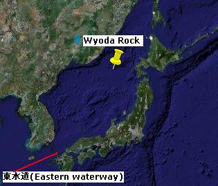
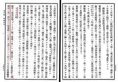
実際、本書においては第三編 朝鮮南西岸 朝鮮海峡 の最後に"西水道"、"東水道"がそれぞれ次の第四編に記される現竹島と同じ種類の項目として挙げられています。しかし、"西水道"は対馬と朝鮮国センチネール島の間の今日の朝鮮海峡ですが、"東水道"は対馬と壱岐の間の海峡であり、明らかに日本の領土内にあります。この事一つをとっても、各項目がそもそも領土を規定する為の目的で列記されたのではなく、例え日本の領土であっても当該国(朝鮮)沿岸に通漁する漁船などの船舶の安全航行の為に必要な情報を列記したものであることは明確です。さらに、第四編"リヤンコールト列岩"、"鬱陵島(一名松島)"に続いて記載されたワイオダ岩は、実際はその存在が確認されないもので1894年版の英海軍の水路誌にはその点が明記されいますが、いずれにせよ北緯41度14分30秒 東経137度14分 と、ロシア沿海州と北海道の間にあり、朝鮮国の領土から大きく外れているのに、全く同様に記載されている事からも、やはり本書の各項目が領土とは無関係である事は疑いの余地はありません。また、これらの項目は殆どが英国海軍発行の"China Sea Directory"からの翻訳であり、日本の海軍が朝鮮の領土として判断した上で記述していたとは考えられません。 しかも朝鮮東岸の日本海に注意すべき岩礁として列記されているに過ぎないことが、その記述から明確です。現竹島が江戸時代から鮑やアシカの好漁場として利用されてきただけでなく、江戸時代から鬱陵島への中継地点や道しるべとして、現竹島は日本の漁民や商船にとっては長らく日本海に浮かぶ大変重要な島の一つでした

また、本書の総記において朝鮮国の東限が東経130度35分と現竹島を朝鮮領土から除外している事は先に記しました。ここで南限が北緯33度15分と、済州島から南に11km離れた所に位置する馬羅島(Mara-do)(北緯33度7分)を含んでいないことを持って、現竹嶋などの附属島嶼を本来含まない記述であるとする韓国側の反論があります。しかし、戦後竹島領有権を主張し始めた韓国政府に、理論的アドバイスをしていた歴史学者・崔南善は著書「朝鮮常識問答」(1946)で、次のように述べています

”問:我が国は地図上においてどの位置にあるか?”

”答:朝鮮半島自体は東経130度41分22秒から124度18分35秒、北緯34度14分16秒から43度0分36秒の間にある。大小の島を含めれば、東経130度56分23秒から124度11分00秒、北緯33度6分40秒から43度0分36秒の間にある。”“島嶼部を含むならば、最東端は慶尚北道鬱陵島竹島(竹嶼)(*訳注)、最西端は平安北道龍川郡薪島面馬鞍島、最南端は済州道大静面馬羅島、最北端は咸鏡北道穏城郡柔浦面である”

鬱陵島竹島とは、現竹島ではなく、韓国の古地図や文献において1700年代以降于山島として描かれ続けてきた鬱陵島の東2km沖に浮かぶ竹嶼です。また、同人による「朝鮮常識」(1948)でも島嶼を含めた韓国の東端が130度56分23秒であり、鬱陵島の隣接島である竹嶼(韓国名竹島)が韓国領土の東端で、極南が北緯33度6分40秒の馬羅島であると記しています。1948年においてさえ、馬羅島は領土として明記しているものの、現竹島(東経131度52分) は韓国領土から除外しています。つまり、本書に馬羅島を含まなかったことが、現竹島を鬱陵島附属島嶼として認識していた事を証明するものではないことが分かります。

また、この朝鮮国東限が鬱陵島ではなく豆満江を基準としていると言う指摘も見受けられますが、第四編の豆満江の項では、その朝鮮領土東限としての記述はおろか、河口である東端の経度の明記もありません。従ってやはりそのような指摘は、本書に関する限り事実に基づかない推測に過ぎない事が分かります。

以上のように、本書は日本海軍、特に水路局長肝付兼行が現竹島が朝鮮領土外である事を明確に認識していたという証拠であるとともに、実際はその東限とされた130度35分より東にあり、現竹島以上に戦略的に重要で実際に海底ケーブルも望楼も設置した鬱陵島を、強制的に編入などしなかった、1905年当時の明治政府が、内藤氏の主張するような領土拡大の野望を持って竹島の島根県編入を秘密裏に行ったようなのではなく、国際法に基づいた適切な対応をしていた事を証明する貴重な資料でもあると言えるでしょう。

新羅時代から1948年に至るまで現竹島をその領土内として認識していた明らかな形跡がただの一つもないのにも関わらず、竹島だけでなく対馬、さらには波浪島と言う存在があやふやな島までその領土に編入する事を要求した上に、サンフランシスコ条約締結直前三ヶ月前に突然所謂李ラインと言う国際的ルールに基づかない国境を一方的に画定し竹島を不法占拠し、それを越える日本漁船を一方的に機関銃等で銃撃(2007年7月5日 山陰中央新報 )(魚拓)するなどし、日本の漁民44名を死傷させるに至らしめ、約四千人を拿捕、抑留した上日韓交渉を有利に進める人質外交を行った韓国こそが、侵略的な領土拡大という国際的犯罪行為を行った張本人であることは明確です。韓国が1905年の明治政府による平和的な島根県への編入を、本来無関係である帝国主義にことさら結びつけて愛国心を煽り、自国に有利な世論に持ち込もうと必死なのは、こうした都合の悪い事実を覆い隠そうとする意図があるのでしょうか。

「朝鮮水路誌」(明治二十七年)の全文は国立国会図書館のホームページ から閲覧可能です。

1894 朝鮮水路誌 第一篇総記1894 朝鮮水路誌 序_21894 朝鮮水路誌 序_11894 朝鮮水路誌 序_11894 朝鮮水路誌 第四篇_31894 朝鮮水路誌 第四篇_4

22.2.08

Happy Takeshima Day !

Today is the 3rd Takeshima Day. I hope everyone who could attend the ceremony in Shimane enjoyed the program and more member of the National Diet will attend next year.

Today, San-in Chuo Shinpo(山陰中央新報) reported about the Korean article of 「皇城新聞」, in July 13th, 1906, which we have already talked about here. The article confirmed "Seokdo(石島)" in the Great Korean Empire's Ordinance No.41 which orderd to set the Uldo County in 1900 was not Takeshima/Liancourt Rocks at all. Prof.Shimojo of Takushoku University and Mr. Sugihara from former Takeshima Research Group confirmed this article and highly valued this finding. Mr. Sugihara told that it is a collaborating evidence to support Takeshima Research Group's conclusion.

Facts on Arrangement of Uldo County

The Resident-General sent an official letter to the Interior Ministry asking it to clarify what islands belonged to Ulleungdo, which is under the administration of Samcheok County in Gangwon Province, and the year and month the county office was established. The response was that the post of Ulleungdo Administrator was established on May 20, 1898, and then on October 25, 1900, the government decided to post a county magistrate with the county office being at Daehadong (台霞洞). It said the islands under the authority of the said county were Jukdo (竹島) and Seokdo (石島), and that it was sixty ri from east to west and forty ri from north to south for a total of 200 ri.

Reference : 「石島=独島」説否定の記述見つかる (山陰中央新報 22/02/2008 : Japanese) Cache

20080222 山陰中央新報 鬱陵島配置顛末

Surely you are joking, Prof. Hosaka ! (ご冗談でしょう、保坂先生!)

Professor Hosaka, a naturalized Japanese-Korean, who falesly claims finding the evidences of Japan's so-called renouncement of Takeshima/Dokdo did it again. Despite of his efforts, all he had found so-far only makes him doubtful as a decent scholar.

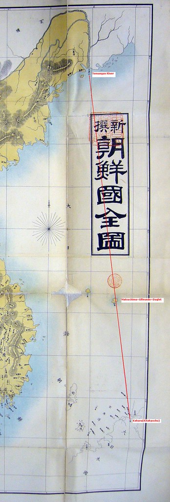
This time, he claims that the map called 「新撰朝鮮全図(Newly Made Whole Map of Chosun Country) 」 (1894) by Japanese civilian 田中紹祥 is a proof that Japan recognized Takeshima/Dokdo as Korean territory.

Notice that the lines are neither latitude nor longitude. In this map, vertical lines are numbered, from right to left, as 8, 9, 10, 11,… in Chinese characters (八, 九, 十, 十一,…), and horizontal lines are numbered, from bottom to top, as 32, 33, 34, 35,… (三十二, 三十三, 三十四, 三十五,…). Since lines are drawn in equal spacing for both vertical lines and horizontal lines, the grids form squares in this map. The positions of the lines correspond to neither longitude nor latitude used in canonical maps. ( explained by Aki here.) If you see the location of Tsushima, you will instantly notice that those lines are not longitude nor latitude in fact. (Update : The lines of the map seems to be incorrect longitude lines, which was not drawn in east longitude based on the Greenwich point but it was drawn in west longitude based on the Japanese standard point at Azabu, Tokyo (139 degree 44' 28" E). Read more.)

The so-called Matsushima locates on the line from Tomangan River and to Kokura, Kitakyushu on the map. It's definately Ulleundo=Daglet as you can see on the modern map below, and Takeshima on that map is non-existant Argonaut apparentrly. It only shows that Japanese are still confused of the two islands(Argonaut=Takeshima, Daglet=Matsushima=Ulleundo), and also that Japanese excluded today's Takeshima/Liancourt Rocks/Dokdo from this map of Whole Choson.

It is well-known that Japanese in Meiji called Ulleundo as Matsushima which they used to call Takeshima/Dokdo and Takeshima as well. It explains why Meiji Government used the expression "other island" in Dajoukan order in 1877 which excluded "Takeshima and other island" which has no name on it. This "other island" is apparently this Matsushima (Ulleundo) or Jukdo which was labelled as "Mano-shima" on the map attached to the order, which has no record in Japanese documents.

I understand Korean desperately feel like doing "something" since it's a Takeshima Day in Japan. But professor, this is too shabby. I sincerely hope intelligent Koreans will not be fooled by his tactics.

Surely you are joking, Prof. Hosaka !

Ref : “独島=韓国の領土”立証する日本古地図発見…保坂祐二教授 その① ②(Japanese)

1894-新撰朝鮮国全図_1_2._3 2006 国際関係が分かる世界地図096

Other maps which Prof. Hosaka falesly insists Ulleundo=Daglet=Matsushima as Takeshima/Dokdo.

吉倉清次郎「実測日清韓軍用精図」(1895)

鈴木敬作「朝鮮國全圖」(1882) , 大須賀龍潭「大日本全圖」(1883)

1656 - 柳馨遠 『輿地志』 (「東国興地志」巻之七 江原道 蔚珍)

柳馨遠(1622~1673)は、朝鮮王朝、顕宗王の時の実学者で、1656年に全国地理の本である「東國輿地志」を編纂しました。(ソウル大学奎章閣サイト・韓国語

韓国側は「東国文献備考・與地考」(1770)や「萬機要覧」(1808)に「輿地志に謂う、鬱陵、于山皆于山国の地。于山は即ち倭の所謂松島なり」と言う引用がある事を挙げ、安龍福の渡航や日本よりも古い文献に倭の松島(現在の竹島)が于山島だと認識していたという論拠としてきました。この本は長く遺失されたとされてきましたが、2006年に済州大学の呉相学氏によって確認された「東国興地志」には下記のように書かれており、実際は従来からの日本側の主張のように、「于山は即ち倭の所謂松島なり」と言う記述は無かったことが明らかになりました。

「于山島鬱陵島 一云武陵 一云羽陵 二島在県正東海中 三峯及業掌空南峯梢卑 風日清明則峯頭樹木 及山根沙渚 歴々可見 風便則二日可到 一説干山 鬱陵 本一島 地方百里」

ちなみにこれは「新増東国輿地勝覧」 の記録をそのまま引用していることが分かります。

「于山島鬱陵島 一云武陵 一云羽陵 二島在県正東海中 三峯及業掌空南峯梢卑 風日清明則峯頭樹木 及山根沙渚 歴々可見 風便則二日可到 一説干山 鬱陵 本一島 地方百里」

安龍福の竹島一件の後、安の証言である「于山は即ち倭の所謂松島なり」という言葉が「輿地志」に書かれてあったと言う、誤った記述が、1700年以降の「東国文献備考」や「萬機要覧」を始めとする朝鮮の書物に登場するようになり、韓国側もこれらの文献をを根拠に于山島が竹島・独島(倭の松島)であると主張します。しかし、以下のように文献を年代にそって並べると、申景濬が1756年の「疆界誌」の中で輿地志の記録の後に“所謂松島 ”と言う自説を追記していること、1770年の「東国文献備考・與地考」でそれを「輿地志」の記述であるかのように書き変えている事が明確に分かります。以降に編纂された「萬機要覧」 「増補文献備考 輿地考」は、原著である「輿地志」からではなく、「東国文献備考・與地考」からの孫引きで引用している為、この誤記が受け継がれていったようです。

1756 - 申景濬「疆界誌」『旅菴全書』巻之七 「疆界考」十二 鬱陵島

「按 輿地志云 一説于山鬱陵本一島
而考諸圖志二島也 一則其所謂松島
而蓋二島 倶是于山國也」

1770 - 申景濬・洪啓禧 「東国文献備考・與地考」 

「輿地志云 鬱陵 于山 皆于山國地 于山則倭所謂松島也」

1808 - 「萬機要覧 軍政篇 (1937 朝鮮総督府)」

「輿地志云 鬱陵于山皆于山国地. 于山則倭所謂松島也.」

1908 - 李萬運「増補文献備考 輿地考」

「輿地志云 鬱陵于山皆于山国地. 于山則倭所謂松島也」

このように流れを追っていくと、申景濬が「東国文献備考・與地考」を編纂する際に、自分の意見をあたかも輿地志からの引用であるかの如く改竄している事が分かります。、誤記であることが明らかな文献を根拠として領土の根拠として主張することは、愚かであると言わざるを得ないのです。

1656 柳馨遠「東国輿地志」表紙 1656 柳馨遠「東国輿地志」_1 1656 柳馨遠「東国輿地志」_2

18.2.08

2008 Feb 7 - New Article on Gerry from "San-in Chuo Shinpo"(山陰中央新報)

Below is a translation of the new February 7, 2008 article on Gerry in the Japanese newspaper San-in Chuo Shinpo (山陰中央新報).

The excessive anti-Japan movement that took place in March 2005 in Korea has died down now. Shimane Prefecture established "Takeshima Day" that year. Mr. Gerry Bevers, a teacher of English at a university near Seoul studies the history of Takeshima and analyzes the changes as follows.

" I think part of the reason for that is that many Koreans have turned their attention toward China and the historical disagreements that exist between China and Korea, but I also think that the Korean government has realized that talking about the history of Takeshima (Dokdo) has done more harm than good since the history supports Japan's claims on Takeshima."

He posted articles on the Internet about Korea's old documents and maps that did not support the Korean claim, which led to his being fired from a university last year.

"I now have a teaching job at another Korean university that I am very satisfied with. I enjoy living in Korea because Koreans are very friendly people, but the problem is that Koreans seem to think that anyone who disagrees with them on Dokdo (Takeshima) are anti-Korean. That is simply not true."

Lee Myung-bak will take office as new President on the 25th of next February. He will place more importance upon the relation with Japan.

"I think Lee Myung-bak is a pragmatic politician that wants to improve relations
with Japan and will, therefore, try to avoid making Takeshima (Dokdo) an issue
by continuing to pretend that there is no dispute with Japan over the islets. However, there are still anti-Japanese groups in Korea that he may sometimes have to appease in someway, so the issue may still come up."

While the anti-Japan movement has died down, Korea still seems to assert her claims on
Takeshima by doing such things as sitting up polling booths. On the other hand,
the Japanese government hasn't done anything to speak of.

"There are hardcore anti-Japan advocates in Korea. Old documents and maps clearly support Japan’s historical claims on Takeshima, so the Japanese government needs to stop being so passive about this issue and start translating and writing the books
and brochures that will prove their claims to the world because I am almost positive that Korean historians will continue to distort the facts to support their false claims. However, telling the truth about the history and settling the dispute are two different things."

Gerry has studied the history of Takeshima for 3 years after feeling there was something wrong about the anti-Japan sentiments in Korea. He is confident that there is no evidence that Takeshima was ever Korean territory.

"I have pretty much answered all the questions I had about the Takeshima-Dokdo issue, so I am not really doing any new research right now. What I want to do now is to review and organize the information I do have because I am thinking about writing a book. I think I have learned the truth about Takeshima, and I want others to know it, too."

via ZERO
Courtesy of 
The San-in Chuo Shinpo(山陰中央新報)

13.2.08

The 4th column “Seeking Truth Based Solely on Facts(実事求是)” by Prof. Shimojo Masao

Below is a translation of The 4th column: “Seeking Truth Based Solely on Facts (実事求是),” by Prof. Shimojo Masao

"Errors in Educational Video Produced by the Northeast Asian History Foundation (東北アジア歴史財団)."

The Northeast Asian History Foundation of Korea has produced an educational video that was made public on January 18, 2008. The video deals with the Takeshima (Dokdo) issue, and includes interviews with three specialists: Hong () Song-kun, Naito Seichu(内藤正中) and Kim Byeong-yeol (金柄烈). The problem with the video is that no evidence was shown to prove that Takeshima (Dokdo) was Korean territory, and their arguments include errors.

The first speaker, Hong () Song-kun, mentioned a Japanese document entitled, 元禄九丙子年朝鮮舟着岸一巻之覚書 (Memorandum on the visit of a Korean ship in the 9th year of Genroku)" and claimed that it was proof that Takeshima (Dokdo) was Korean territory. He claimed it was a report on the investigation on Ahn Yong-bok and said, “It clearly said that Dokdo belonged to Gangwondo (江原道).” However, if you read the “元禄九丙子年朝鮮舟着岸一巻之覚書,” you realize that it was not a report on the investigation, but only a transcript of Ahn Yong-bok's testimony, where Ahn said, “Japan's Matsushima is Jasando (子山嶋) and is part of Ganwon Province (江原道). Japan did not admit Takeshima (Dokdo) was Korean territory. In fact, the Tottori clan did not take him seriously and deported him from Karo-nada (Sea of Karo). In the light of these facts, it is clear that Hong’s theory was wrong.

The reason Koreans today applause Ahn Yong-bok’s activities is because the testimony Ahn gave to Korean officials was recorded in the “Annals of King Sukjong (粛宗)”. However, testimony written in both the “Annals of King Sukjong (粛宗)” and in the “漂人領来謄録” is considered unreliable since the testimony Ahn gave to the Japanese and the testimony he gave to the Koreans do not match in certain parts. In other words, Ahn perjured himself.

Hong () also said that Usando was clearly written as Japan’s so-called Matsushima (Dokdo) in the "Mangi Yoram 萬機要覽," which was a Korean text published in 1808; however, it seems Mr. Hong did not read the original text. The article that Mr. Hong based his claim begins with, “According to the 文献備考”, which was requotation of the “東国文献備考” (1770), and the article in the “東国文献備考” was fabricated by Sin Gyong-jun (申景濬) when he compiled the "Yojigo (輿地考)." He changed the text in the “輿地志” to “Usando is Japan’s so-called Matsushima (Dokdo),” based on his book, "Ganggyego 彊界考." Therefore, the statement that Mr. Hong said was proof that Usando was Dokdo was a requotation from a fabricated document.

The same goes for Naito Seichu, who said that making a voyage to Ulleungdo during the time of Korea’s empty island policy was like going into someone's empty house, and he called it a "thief mentality." However, the Edo Shogunate regarded Ulleungdo as Japan’s territory when the chief fishermen of the Oya family clan in Yonago, Tottori brought Ahn Yong-bok and Park O-dun (朴於屯) back to Japan. However, as the Tsushima clan negotiated with Korea on orders from the Shogunate, opinions inside the clans split into two parties. One party thought that Ulleungdo was Japan’s territory, and the other thought it was Korean. The former party made their argument based on the fact that Japan effectively controlled the island for over 80 years. In the end, it was the Tsushima clan who proposed stopping the negotiations and conceded that Ulleungdo was Korean territory because of the evidence in Korea's "Dongguk Yoji Seungram (東国輿地勝覧)." Therefore, Naito Seichu was wrong to say Japan had a "thief mentality."

The last speaker was Kim Byeong-yeol (金柄烈). He called the incorporation of Takeshima (Dokdo) into Shimane prefecture "an invasion." He also said, “You could incorporate it if it were ownerless land, but Takeshima (Dokdo) was Korean territory.” He mentioned the activity of Ahn Yong-bok as grounds of his claim and say that "Seokdo" in the 1900 "Ordinance #41" was Dokdo. However, there is no historical evidence to support Ahn Yong-bok's claims. For example, Takeshima (Dokdo) was not drawn in such Korean maps such as the "Ulleungdo Dohyeong (欝陵島図形),the "Ulleungdo Woido (欝陵島外図)," or the Daehan Jeondo (大韓全図)." Takeshima (Dokdo) was outside Korean territory and was certainly “terra nullius." Japan incorporated ownerless land, and it was acceptable under international law, as Kim pointed out.

They put the educational video up for viewing on January 18th, the very same day that Korea invaded Takeshima (Dokdo) after drawing the “Rhee Syngman Line” on the open sea. The problem is that there was no historical grounds for Rhee Syngman to draw the line. As Mr. Naito expressed in the Northeast Asian History Foundation's educational video, Rhee's action was based on "thief mentality."

Translated by Pacifist

Courtesy of Web Takeshima Research Center.

Other Column of the Series:

The 24th column “South Korean Government dug their own grave by publishing the English version of "The Dokdo/Takeshima Controversy" by Prof. Emeritus Naito Seichu and Mr. Park Byeong-seop.”


The 23rd column " Refutation against the report of South Korean Yonhap News Agency which misread the Mori Kohan(森幸安)'s "The Map of Tsushima(對馬輿地図)"


The 22th column “ Refutation against "The Meiji Government's recognition of Takeshima=Dokdo" by Mr. Park Byeong-seop(朴炳渉)””, Part 1, Part 2, Part 3, Part 4

The 21st column " Refutation against "Analysis of Shimojo Masao's Editorials" by Mr. Park Byeong-seop(朴炳渉)”

The 20th column “Act of Folly by "Northeast Asian History Foundation"”

The 19th column “"Korea Maritime Institute(KMI : 韓国海洋水産開発院), who lacks ability to read their own historical documents, criticized on Shimane Prefecture. "”

The 18th columnAbsurd and Peculiar Theory of Prof. Hosaka, plus the "Children and textbook nationwide net 21" and others' Getting "Out of Control.”

The 17th column “The Ordinance of Prime Minister and Cabinet Office, No.24 and the Ordinance of the Ministry of Finance, No.4 in 1951(昭和26年).

The 16th column ""Dokdo Month" without any historical grounds."

The 15th column " South Korea's Groundless Claim of "Inherent Part of (Korean) Territory"

The 14th column “A reckless Courage of the Professor Kimishima Kazuhiko(君島和彦) of Tokyo Gakugei University(東京学芸大学).

The 13th column “Sins of Asahi Shimbun and Mr. Wakamiya Yoshibumi(若宮啓文).

The 12th column “Northeast Asian History Foundation and Dokdo Research Center's Misunderstanding”

The 11th column “South Korea's Misunderstanding of 'A Map of Three Adjoining Countries (Sangoku Setsujozu 三国接壌図)' by Hayashi Shihei(林子平)”

The 10th column " A Blunder of Sokdo(石島) = Dokto(独島) Theory

The 9th column "Criticism on Dokdo Research Center”

The 8th column “The Historical Facts" The 6th column “Onshu-shicho-goki (隠州視聴合記)" and the "Nihon Yochi Totei Zenzu (日本輿地路程全図)" by Nagakubo Sekisui(長久保赤水)"

The 5th column “South Korea’s erroneous interpretation of the document 'Takeshima and Another Island are Unrelated to Japan"

The 4th column “Errors in Educational Video Produced by the Northeast Asian History Foundation (東北アジア歴史財団)."

10.2.08

Late 18th c., "Joseon Paldo Jido," Ulleungdo & Usando

Below is a cutout of the Korean island of Ulleungdo (鬱陵島) from the late 18th century Korean map, "Joseon Paldo Jido" (朝鮮八道地圖), which is stored in Seoul National University's Gyujanggak Institute for Korean Studies. Notice that the map shows "Usando" (于山島) as a small, neighboring island off Ulleungdo's northeast shore.

Korea claims that Usando was the old Korean name for "Dokdo" (Liancourt Rocks), but this map and many others show that Usando was just a small, neighboring island of Ulleungdo, most likely Ulleungdo's present-day neighboring island of Jukdo (竹島).

"Joseon Paldo Jido," Late 18th c.; Ulleungdo (鬱陵島) & Usando (于山島)
Late 18th c. Joseon paldo jido

Below is the full map:

"Joseon Paldo Jido," Late 18th c.


1877 Jpn Map Shows "Matsushima" (松島) as Japanese

Below is a link to an 1877 Japanese map that shows "Takeshima" (竹島) as Korean territory, but "Matsushima" (松島) as Japanese. However, the island the mapmaker believed to be Takeshima (Ulleungdo) seems to have been the non-existant island of Argonaut, while Matsushima seems to have been the real Ulleungdo. At the time, there was confusion in Japan about the location of Matsushima (松島), but this map is evidence that regardless of its location, Japanese associated the name Matsushima with Japanese territory.

Click on the link and then click on "1" to see the overall map, and "3" to see the closeup view of Takeshima and Matsushima.

Link to the Map

7.2.08

1906 July 13, "Hwangseong Shinmun" (皇城新聞) Reports Boundry for Uldo County that Excluded "Dokdo"

In a July 13, 1906 article in the Korean newspaper, "Hwangseong Shinmun" (皇城新聞), it was reported that the Japanese Resident-General asked the Korean Ministry of Interior to clarify what neighboring islands were part of of "Uldo County" (Ulleungdo County). It also asked for the date the county office was established there.

The Korean ministry replied that the county was established on October 25, 1900, and that the neighboring islands were Jukdo (竹島) and Seokdo (石島). The Korean ministry also gave the dimensions of Ulleungdo as being sixty ri from east to west and forty ri from north to south for a total of 200 ri. Since a Korean ri was 0.4 kilometers, that means Uldo County was defined as having an area of 24km x 16km.

The 200 ri figure referred to the perimeter of the county (60 + 60 + 40 + 40 = 200), which converts up to 80 kilometers.

This article is very important in the Dokdo/Takeshima debate because it is evidence that the Korean government in 1906 did not recognize "Dokdo" (Liancourt Rocks) as being part of Uldo County since Dokdo is about 90km southeast of Ulleungdo.

It is quite probable that the Japanese request for clarification of the neighboring islands of Ulleungdo was caused by recent Korean newspaper reports saying that Japan had incorporated an island named "Dokdo" (Liancourt Rocks), which the Uldo County Magistrate thought was part of his county, even though he did not know exactly where it was. Since the magistrate had been ordered by his superiors to confirm the status of Dokdo, and since the Korean government did not include Dokdo in their reply to the Japanese request months later, we can assume that the investigation revealed that Dokdo was not a part of Ulleungdo.

The article was apparently discovered by a Mr. Sugino Yomei (杉野洋明), who wrote about it in Japanese on his site HERE. Below is the article and my translation. The newspaper page the article came from can be found HERE:
Facts on Arrangement of Uldo CountyThe Resident-General sent an official letter to the Interior Ministry asking it to clarify what islands belonged to Ulleungdo, which is under the administration of Samcheok County in Gangwon Province, and the year and month the county office was established. The response was that the post of Ulleungdo Administrator was established on May 20, 1898, and then on October 25, 1900, the government decided to post a county magistrate with the county office being at Daehadong (台霞洞). It said the islands under the authority of the said county were Jukdo (竹島) and Seokdo (石島), and that it was sixty ri from east to west and forty ri from north to south for a total of 200 ri. 
 鬱島郡의 配置顛末
統監府에서 內部에 公函하되 江原道 三陟郡 管下에 所在 鬱陵島에 所属島嶼와 郡廳設始 年月을 示明하라는 故로 答函하되、光武二年五月二十日에 鬱陵島監으로 設始 하였다가 光武四年十月二十五日에 政府會議를 經由하야 郡守를 配置하니 郡廳은 台霞洞에 在하고 該郡所管島는 竹島石島오、東西가 六十里오 南北이 四十里니, 合 二百餘里라고 하였다더라.

6.2.08

Wikipedia Drops "History" Section from Liancourt Rocks Description

Today I noticed that Wikipedia has dropped the history section from its description of Liancourt Rocks. (See HERE.) Apparently, the online dictionary got tired of the back-and-forth debate between those claiming the rocks belong to Japan and those claiming they belong to Korea. Instead, they have included a section called "International Dispute," which says the following:

There are conflicting interpretations about the state of sovereignty over the islands in pre-modern times. A Korean claim is partly based on references to a Korean islands called Usan-do in various historical records and maps. According to the Korean view, these refer to today's Liancourt Rocks, while the Japanese side argues that they must refer to a different island, today called Jukdo, a small islet located in the immediate vicinity of the nearest larger Korean island Ulleung-do.

Japan officially incorporated the islands as part of its territory in 1905, shortly before it occupied Korea itself as a protectorate.

The present-day conflict largely stems from conflicting interpretations of whether Japan's renunciation of sovereignty over its occupied territories after the Second World War was supposed to cover the Liancourt Rocks too. A decision by the Supreme Command of the Allied occupation powers (SCAP), Instruction #677 of January 29, 1946, listed the Liancourt Rocks as part of those territories over which Japanese sovereignty was to be suspended, but the final peace treaty between Japan and the Allied powers, the Treaty of San Francisco, did not mention them.


Maybe the above was the only way for Wikipedia to deal with the problem of people always changing the history section to suit their biased views of history, but it means the dictionary has decided not to talk about the history. Unfortunately, the references it used for the article almost all point to Korean sites, which do distort the history of the islets.

5.2.08

Chungwanji (春官志): "Ulleungdo is called Sambongdo (三峯島)"

In 1744, King Yeongjo (英祖) commanded Lee Maeng-hyu (李孟休) to compile a book of rites, customs, and legal precedents. The result was a 3-volume set of books called the "Chungwanji" (春官志).

The third volume of the set included exchanges between Korea's emissaries to Japan and their Japanese counterparts. Among the exchanges in the book was one entitled "The Ulleungdo Boundary Dispute" (鬱陵島 爭界), which was a 14-page description of Ulleungdo and the territorial dispute over the island between Korea and Japan following the An Yong-bok (安龍福) incident in the 1690s.

I hope to translate into English all fourteen pages of "The Ulleungdo Boundary Dispute" in the near future, but now I just want to introduce a short discription of Ulleungdo from the book that I found interesting because it clearly says that another name for Ulleungdo was "Sambongdo" (三峯島), which means "Island of Three Peaks." That is interesting because Korea has claimed that Sambongdo was an old name for "Dokdo" (Liancourt Rocks), but she has no documents or maps to back up that claim. On the other hand, the three high peaks of Ulleungdo were frequently mentioned in old documents.

Here is the quote for the "Chungwanji" (春官志):

盖 是島 以其産竹也 故 謂 竹島 以有三峯也 故謂 三峯島 至於 于山 羽陵 蔚陵 武陵 礒竹 皆音 轉 訛而然 也

대개 이 섬은 대가 나는 까닭에 죽도(竹島)라 이르고 세 봉우리가 있기 때문에 삼봉도(三峰島)라 하며, 우산(于山)이니, 우릉(羽陵)이니 울릉(蔚陵)이니 무릉(武陵)이니 의죽(礒竹)이니 하는 것은 모두가 발음이 잘못 전해져 그런 것이다.

In general, this island is called Jukdo (竹島) because bamboo (竹) grows on it. It is called Sambongdo (三峰島) because it has "three peaks" (三峰). Usan (于山), Uleung (羽陵), Ulleung (蔚陵), Muleung (武陵), and Wuijuk (礒竹) are all mispronunciations.

Chungwanji 03a

The above quote also appeared in the late 19th century Korean text, "Dongjeongo" (東典考), which you can see below:

以産竹故謂竹島有三峯故謂三峰島于山羽陵蔚陵武陵蟻竹皆音訛而然也[春官誌]
Late 19th c. - Dongjeongo 03

1.2.08

San-in Chuo Shimpo: "Usando (于山島) = Jukdo (竹嶼), Documented for the First Time"

The following is a translation of a January 19 article from the Japanese newspaper, "San-in Chou Shimpo":

"Usando (于山島) = Jukdo (竹嶼), Documented for the First Time"

An old Joseon Dynasty document has been found that shows that Usando was the old name for Jukdo (竹嶼 in Japanese or 竹島 in Korean), which is an island off the northeast shore of present-day Ulleungdo. South Korea has claimed that Usando was Takeshima (Dokdo in Korean), the sovereignty of which is claimed by both Korea and Japan. The Takeshima Research Center of Shimane Prefecture has used old maps to claim, "Usando was not Takeshima/Dokdo but Jukdo," but this is the first time a document has been found to prove the claim.

The document comes from the "Ilseongrok (日省錄) ", which was a Korean record of daily affairs of state from 1760 to 1910. American Gerry Bevers (52), who researches the Takeshima/Dokdo issue in South Korea, introduced the document on the Internet.

In an 1807 report in the "Ilseongrok (日省錄), a Korean government official, who surveyed Ulleungdo, described Usando as being to the north of the island and having a circumference of two to three Korean ri (里), which was 800 to 1200 meters (北有于山島周回為二三里許). Jukdo is the only island around Ulleungdo with such a large circumference.

Jukdo is off the northeast shore of Ulleungdo and reaches almost 700 meters from north to south. In contrast, Takeshima/Dokdo is located ninety-two kilomethers southeast southeast of Ulleungdo. Mr. Bevers concluded, "At any rate, this 1807 report says that Usando was a neighboring island of Ulleungdo."

Professor Masao Shimojo of Takushoku University, who served as the chairman of the Takeshima Issue Society, evaluated the document by saying, "Though old maps had already made it clear that Usando was not Takeshima/Dokdo but Jukdo, the document is meaningful because it corroborates the maps." South Korea researchers had been refuting the claims of the Takeshima Research Center of Shimane Prefecture by saying, "More value should be put on documents than maps." Professor Shimojo quoted the Korean refutation and then said, "The opinion of the Takeshima Research Center been proven to be correct."